As the American West warms, there’s a growing intersection between wildfires and the mountain snowpack that supplies the bulk of the water in many rivers and reservoirs.
Fire is a natural and beneficial component of many Western ecosystems, but blazes are now reaching higher elevations, raising questions about how the snowpack behaves in burned areas—and how downstream users and species will be affected.
If a fire torches a forest’s canopy, that change can actually let snow accumulate faster in winter since falling flakes aren’t intercepted by branches and pine needles.
But without that canopy, the snowpack also loses shading from the sun and is subject to more wind, both of which can accelerate the snow’s disappearance. Moreover, soot and ash from charred tree trunks can hasten melting by coating the normally reflective snow with darker, heat-absorbing material.
To tease out the effects, researchers have been monitoring the site of a record-breaking wildfire in the mountains west of Fort Collins. The latest study to emerge from their research on the 2020 Cameron Peak Fire concludes that burned areas can lose their snowpack more rapidly, especially on south-facing slopes exposed to more sun.
The Cameron Peak Fire, which burned 208,913 acres, or about 326 square miles, is the largest wildfire in Colorado’s recorded history. The blaze, thought to be human-caused, burned nearly 500 structures and took nearly four months to be contained.
“The fire area that we studied was completely burned, so I like to describe it as a bunch of burnt toothpicks,” said Wyatt Reis, a co-author of the September study in Water Resources Research and a former graduate student at Colorado State University. “The trunks of the trees are still there, there’s really no branches on most of them anymore, and there’s definitely no canopy at all. So you just have these pillars of charred trunk.”
How the snowpack responds after a fire
The scientists found that a slope’s aspect—its orientation toward the sun—is a crucial determinant of the snowpack’s fate. In the burned area, the snowpack reached its maximum water content on the sunny, south-facing aspect “22 days earlier than all other sites, which peaked simultaneously,” according to the study. Overall, the snow disappeared from burned areas seven to 11 days earlier than in unburned sites.
“We found that the greatest differences were based on aspect regardless of the burn condition,” said Reis. “We get a lot of sun here in Colorado, so that south-facing aspect just starts getting baked earlier in the season than those north-facing aspects, and losing your canopy, you just get all of that shortwave radiation straight into the snowpack and that just starts melting it sooner and earlier.”
The researchers also noted a surprising pattern related to temperature.
“During the winter, the snowpacks on the burned areas were actually colder than they were in the unburned sites. That was something that kind of shocked us at first,” Reis said. “But it makes a lot of physical sense where the trees in the unburned area are kind of acting as a blanket and insulating that snowpack from emitting all of its energy to the cold atmosphere at night or just throughout the day.”
Although the burned areas were colder in winter, that didn’t last.
“In the spring, as our sun angle comes up, as our days get longer, you’re just getting more sunlight and more solar radiation or solar energy into the snowpack,” Reis said. “Losing that canopy then has the opposite effect. Where that canopy is shading the snowpack, keeping it colder, it’s just open to the elements in the burned area.”

Extrapolating to other burns
Generalizing the results from Colorado’s Front Range to other parts of the American West poses challenges because forests, snowpacks and fire regimes vary so greatly in the expansive region, with different conditions in the wetter maritime locations compared to drier, inland mountains.
But two researchers not involved in the Cameron Peak Fire study praised the paper and said it offered important insights that are relevant in many other parts of the West.
“I think they took a really thoughtful approach to this study and I think it’s applicable to more than just that particular location,” said Anne Nolin, professor in the Geography Department at the University of Nevada, Reno.
The Cameron Peak Fire study took place in “the most common forest type across the western U.S. in the mountains,” Nolin said, so “in a lot of ways, it’s pretty similar to a lot of places around the West.”
But the site is higher and colder than the Sierra Nevada, “where we have a lot of fires and a lot of forests that are really moisture-stressed,” Nolin said. “I wouldn’t necessarily expect to see the same results in places that are a lot more humid, like in the Cascades in the Pacific Northwest, especially on the west side of the Cascades. It’s just a lot more humid and the forests are different. They’re more dense there than they are in Colorado.”

Gabrielle Boisramé, assistant research professor at the Desert Research Institute, a Nevada nonprofit, said the findings are “relevant to a lot of places, but you can’t just blanket say, ‘this will apply to everywhere,’ because everything depends on your elevation, your local climate, your fire history.”
“A lot of the work out there is finding basically what they found where you have earlier melt after a fire and faster melt, though a lot of my work that I’ve done in the Sierra Nevada in California actually found the opposite,” Boisramé said.
The locations that Boisramé has studied in the Sierra Nevada differ in significant ways from where the Cameron Peak Fire burned: they’re lower-elevation, warmer forests in which the snow naturally melts earlier. Moreover, they’re subject to more frequent wildfires, so the individual blazes aren’t as severe.
“There’s a lot of different things that affect how the snow’s going to behave, and it’s really hard to disentangle all of them,” Boisramé said.
Another complication is that snow conditions can vary dramatically over short distances.
“If you look at just the scale of one weather station, that might be different than if you looked at the entire hillside because things might be very different right under trees versus in the gaps, or in different size gaps even,” Boisramé said.
Ash speeds melting
A powerful way that wildfires can affect the snowpack is by depositing burned material that accelerates melting. Fresh snow is naturally extremely reflective and has what scientists call a high albedo, but whether it’s ash or airborne dust, darkening the snow surface causes the snow to absorb more energy and disappear sooner.
In the first few years after the fire, “we would really see a lot of that ash deposited on the snow surface, especially during the winter,” Reis said. “However, now in kind of year four, we didn’t see that as much. A lot of that ash has already been blown off the trees since then.”
One interesting finding from the paper, Nolin said, was that the unburned forest also had plenty of material on the snow that lowered the albedo.
“A lot of times we neglect or deemphasize the fact that forests just drop stuff all over the snow, and it makes the snow a lot darker, but what’s different about after a fire is the forest litter, instead of just being like bits of lichen and bark dust and cones and little twigs, it’s black carbon stuff—really, really dark,” Nolin said. “It’s about maybe 10 times more light-absorbing than just regular forest litter.”
In a dense forest, very little sunlight makes it to the ground, so “it almost doesn’t matter what the snow albedo is because there’s so little light coming in,” Nolin said. “But the more light you let in, the more that albedo matters, and so it’s really about that canopy opening up after the fire that matters a lot.”
A wildfire and the subsequent runoff of ash can trigger an immediate crisis for streams and their aquatic wildlife. But scientists have been studying burned areas long enough to know that post-fire impacts to the snowpack and local hydrology can persist for many years beyond that.
“The answer is more than a decade—in some places, over 15 years—we can see this charred black carbon shedding on the snow and causing the snow to melt earlier, year after year after year,” Nolin said.

More wildfires intersecting with snowpack
Wildfires have been integral to many Western ecosystems since time immemorial and are critical to ecosystem health. But today’s blazes are a different beast. Climate change, generations of fire suppression and an ample supply of human-caused ignitions have conspired to create infernos that may burn more intensely, extensively and destructively than under historical conditions.
Previous research has shown that the fire season is lengthening and the acreage burned is rising. Yet another troubling trend is the increasing prevalence of fires in places where they used to be much less common, if not absent.
“The geographical overlap between fire and snow is accelerating,” according to a 2022 review article co-authored by Nolin. “As fires burn larger, more frequently, and higher in elevation, snowpacks are increasingly vulnerable.”
A 2019 study found the acreage burned in the West’s seasonal snow zone increased “at an average rate of up to 9% per year in recent decades as a result of climate warming and a legacy of fire suppression.” A 2021 paper concluded that the biggest increase in burned areas was above 2,500 meters (8,202 feet), where snow tends to persist in winter.
“Forest fires of the western United States have advanced upslope over the past few decades, scorching territories previously too wet to burn,” according to the 2021 paper in the Proceedings of the National Academy of Sciences.
Nolin noted that “the longer the dry season, the bigger the fire season, and the snow season’s getting shorter at both ends.”
In addition to earlier melting in spring, “we also see a significant decrease in snowstorms in November,” Nolin said.
“When I think about climate change, I think about the temperature increasing in both the winter and the summer,” Nolin said. “Overall, to me, that means trees are having to work a lot harder to get the water that they need in order to stay healthy, and so they’re moisture-stressed.”
Many Western forests are also plagued by insect infestations and overgrown due to fire suppression. One troubling result of the increasing intersection between wildfires and the snowpack is the potential for a vicious circle.
“You get this feedback,” Boisramé said, “where you can have more fires because there’s less snow and then, in some places, less snow because there’s more fires and so on and so forth.”
Implications for water managers, ecosystems
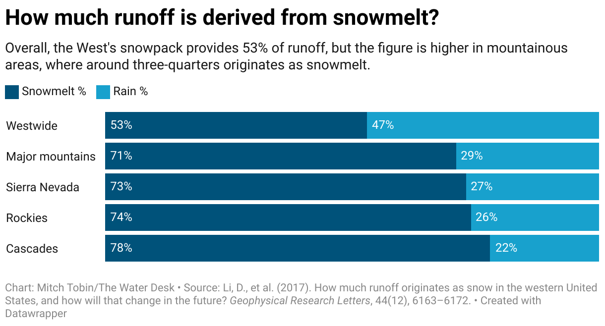
In many Western watersheds, snow accounts for the majority of the runoff that feeds streams and rivers (see this previous post for more precise figures), so the scientists’ findings have major implications for water managers as they try to navigate between droughts and floods.
One implication for water managers is that “if you’ve got a fire that has burned a south-facing slope in the seasonal snow zone, the hydrologic response in that watershed will be very different than if that fire burned on the north-facing slope,” Nolin said. “Fires on south-facing slopes in the seasonal snow zone will have far more impact on streamflow, seasonal runoff, groundwater recharge, compared with fires on north-facing slopes where you have that topographic shading effect.”
In the Sierra Nevada, forests naturally may go for months in summer with little to no rain, so the snowpack plays an important role in sustaining plants and the forest ecosystem.
“Keeping snow on the ground longer is extremely important for that because if you’re a tree, you want the soil moisture to stay high as long as possible because that’s all the water you’re getting in the summertime,” Boisramé said. “The sooner the snow melts, then the sooner the soil starts to dry up.”
Already, climate change is shifting the timing of snowmelt earlier in the season.
“Pretty much all the models agree that, on average, snow is going to be melting a lot earlier,” Boisramé said.
While some post-fire effects are concentrated in the first years after the fire, the loss of the canopy is protracted, if not permanent. For the Cameron Peak Fire and many other blazes in the West, it remains an open question whether the forests will ever recover as the region’s climate changes.
“There really hasn’t been a ton of recovery, especially in the first three years,” Reis said of his study site. “You’re starting to see some saplings come up, particularly on the north-facing slopes now. The south-facing slopes aren’t seeing as much recovery, and that might be due to the earlier snowmelt on those areas. They just don’t have the water resources that they need to start growing.”
Four years after the fire, the saplings are just 12 to 18 inches tall, and they now have to contend with a novel climate that may be inhospitable.
“We don’t know when that canopy might come back and when that shading might come back,” Reis said. “So you might have decades of changed snowpack characteristics.”

The Water Desk’s mission is to increase the volume, depth and power of journalism connected to Western water issues. We’re an editorially independent initiative of the Center for Environmental Journalism at the University of Colorado Boulder.