April 1, the midpoint in the water year, is an important milestone for scientists, water managers, and others who track the American West’s snowpack.
Each watershed has its own typical peak date for the snowpack, but in many places, April 1 has been a traditional moment for taking stock of how the spring snowpack is stacking up.
Accordingly, I’ve collected a variety of maps and charts below that illustrate the state of play on April 1.
Snowmelt accounts for the majority of the flow in many Western rivers, so the current status of the snowpack has major implications for the runoff that will supply downstream ecosystems, agriculture, and communities.
That said, the weather over the next couple of months will play a crucial role in the story of this year’s snowpack. There’s still plenty of time for more flakes to fall in the high country—snow is in the forecast for the next few days—while warm, sunny, and dry conditions could accelerate the meltout.
The map I shared at the top of this post shows a summary of conditions across the West, and it paints a variegated portrait. All of those green areas are close to the 30-year median, but there are also basins with less than 50% of normal (red) or more than 150% of the median (deep blue).
Last year around this time, I did a similar update on the April 1 snowpack and included the graphic below, showing conditions for the last three seasons:
The map below shows precipitation since October 1. As with the snowpack, the Southwest has suffered while portions of Northern California, Oregon, Nevada, and Montana have done well.
Overall, this season’s precipitation patterns “bore the telltale signs of a La Niña influence,” according to a recent post on NOAA’s ENSO blog:
“In particular, most of the southern U.S. and northern Mexico were predicted to be and turned out to be drier than average, with record-dry conditions in southern Arizona and parts of New Mexico. Wetter conditions were forecasted and did prevail over the northern part of the continent, particularly in Alaska and parts of the Pacific Northwest, as well as much farther south in Central America.”
Drilling down to the level of individual states, I looked through a slew of graphics and found a lot of places around average and not worth writing about. But below are a few different types of visualizations from the Natural Resources Conservation Service that caught my eye.
After a dreadful season, March storms were a blessing in Arizona, causing the black line in the chart below to spike upward, but the statewide snowpack was just 44% of the median (green line) on April 1.
In Colorado, which supplies water to 19 states downstream, conditions in the northern portion of the state are near normal, but in the south, it’s a different story: the Arkansas, Upper Rio Grande, Gunnison, San Miguel, Dolores, and San Juan basins are all struggling.
The skimpy snowpack in southern Colorado has pulled the statewide snowpack into below-normal territory. In the chart below, the dotted lines indicate possible trajectories for the rest of the season—a reminder that spring weather remains a wildcard.
In California, where the state runs its own system for tracking the snowpack, conditions are close to normal, but there’s still the same north-to-south gradient that we’ve seen all season. The statewide snowpack was at 96% of normal on April 1, but the northern region was at 118%, and the southern region was at 83%. This is the third year in a row with near- to above-average snowpack in California—something that hasn’t happened in 25 years.
If you’re curious about where there’s still snow on the ground, the two maps below from the University of Arizona’s SnowView interactive show the estimated snow water equivalent across the country and around the West.
The map below displays snowfall accumulation since the start of the water year on October 1. What stood out for me was the unusual swath of snow that fell across the Southeast in January, including a major winter storm in New Orleans.
Snowfall accumulation so far during the 2024-2025 water year. Source: Pivotal Weather.
The map for the U.S. Drought Monitor shows that dry conditions prevail over a large portion of the lower 48 states, with some areas in the West now recording “extreme” and “exceptional” drought.
The graphic below shows how the U.S. Drought Monitor has changed over the past six months. All that yellow, orange, and brown in the Southwest indicates that conditions have degraded so far this water year.
Buckeye, at the western edge of the Phoenix metro region, is the location of a new data center development. (Brett Walton/Circle of Blue)
BUCKEYE, Ariz. – It was supposed to be called Cipriani, a master planned community with more than 9,700 homes at the western fringe of this sprawling desert city in central Arizona.
Plans have changed. One regional growth industry – housing – is being supplanted by another – computing. Even as both carry questions about efficient use of water in one of the driest, fastest-growing areas of the country.
Last August, Cipriani Holdings sold the 2,069-acre land parcel west of the Buckeye Municipal Airport to Tract, a Denver-based data center developer. Instead of housing people, the Cipriani site, now part of the Buckeye Tech Corridor, will incorporate up to 20 million square feet of commercial space to house the cloud.
These are boom times in central Arizona for data centers, particularly in Maricopa County, which is one of the country’s largest data center markets. Factors in its favor, according to Alan Howard, an industry analyst at Omdia, a research firm, include relatively cheap land, tax incentives, low power rates, and proximity to the computing needs of the 5 million people in the Phoenix metro area.
Data centers house the servers and advanced graphics processors that are the foundation of the contemporary internet – and modern life in general. Their purposes range from the small-scale and mundane (storing your beach photos) to the hyperscale and potentially world-changing (training AI models). In aggregate, their power demands and water consumption for cooling have increased exponentially, prompting concerns about the sustainability of data center growth in the Southwest.
Despite the environmental anxieties, there is reason for optimism on water. New data centers are more efficient than older models. Some are using reclaimed water to reduce potable water demand. If the local climate is right, they can use ambient air to cool their servers. Companies like CyrusOne and Microsoft are pioneering cooling systems that consume little or no water in their direct operations, not counting water used to produce their electricity. Though there are tradeoffs involved with energy use, water consumption is increasingly becoming less an absolute constraint and more about the choices companies make.
“I’m far more concerned about energy than water,” said Glenn Williamson, CEO of the Canada Arizona Business Council and chairman of EPCOR Water, a private utility that operates in the state. “For water, we know what we need to do. We just need to pull the trigger.”
New ‘C’ in Arizona’s Economic Geography
The server fervor extends to the highest reaches of government. On January 21, just a day after his inauguration, President Donald Trump hosted a trio of tech industry executives at the White House. Larry Ellison of Oracle, Masayoshi Son of SoftBank, and Sam Altman of OpenAI stood at the president’s side while Trump announced private sector investment in AI infrastructure that could approach $500 billion. For this Stargate Project, he promised the construction of “colossal data centers” to keep America leading the AI race against China.
“I’m going to help a lot through emergency declarations because we have an emergency, we have to get this stuff built,” Trump said.
More and more of this data center “stuff” is being built in Arizona.
School kids learn Arizona’s economic geography via alphabetic repetition. Five C’s were dominant in the state’s early years: cattle, citrus, climate, copper, and cotton. As those industries decline in relative importance, it might soon be time to add a sixth C: computing. Metrics vary, but according to Howard at Omdia, the Arizona data center market is between the fourth and eighth largest in the country. All the big tech companies – Amazon, Google, Meta, and Microsoft – have a presence in the state, as do the less visible names Centersquare, CyrusOne, and QTS.
Arizona encourages the growth of data centers through a sales tax exemption that was approved in 2013. The Arizona Commerce Authority, the regulating agency, says that 64 data centers have received the exemption that covers purchases of hardware and software.
Growth has been accompanied by guardrails. Chandler was the first municipality in the state to regulate data centers. An ordinance adopted in 2022 established siting and noise-reduction requirements, but it did not mention water. The city regulates data center water use through a 2015 policy that limits these facilities to 115 gallons per day, per thousand square feet of space. For additional water needs, the company operating the data center must find an outside source.
Marana, a town 20 miles northwest of Tucson, adopted an ordinance in December that prohibits the water department from supplying data centers with potable water. Companies must find an alternative source and file an application with the town that estimates annual water consumption. No data centers are currently operating in the Marana service area, said Heidi Lasham, the town water director.
In Buckeye, Tract is laying the foundation for a development that could house 40 data centers occupying 20 million square feet at full buildout. Tract’s business model is not to build the data centers, but to acquire land and develop water, wastewater infrastructure, and energy access for the site so that tech companies have a turnkey option for quicker entry into the market.
Tract would not discuss its water plans for the Buckeye development. Graham Williams, chief investment officer, did provide a written statement when asked whether Tract would set water-use requirements for tenants.
“We secure enough water for our sites for a solution that optimizes energy and water use,” Williams wrote. “This is built into our approval process so that our end users are incentivized to maintain these standards since relevant stakeholders have signed off on them.”
In effect, Tract will attempt to balance energy and water demands, since low-water cooling often increases energy consumption.
Terry Lowe, Buckeye water manager, said Tract intends to drill wells on the site to self-supply with groundwater. In the future, he said, Tract will transfer the water system to the city when it no longer wants to be in charge of operating it. A city planning document restricts the site’s groundwater use to 2,000 acre-feet per year.
Tract’s forthcoming groundwater use highlights a loophole in Arizona water law. The state, in 2023, placed a moratorium on new housing developments outside Buckeye whose water source is local groundwater. Existing housing developments that pump groundwater must pay to recharge what they use. Neither provision applies to industrial developments like Tract’s data centers that are located in areas without a renewable surface water supply. This irritates the homebuilding lobby, which complains of unequal treatment.
Amber Walsh, an analyst with Bluefield Research, said that data center water use is a complex topic because of rapid technological change in the industry. Total water demands at present have accelerated, even as individual data centers become more efficient. When viewed nationally, all those drops, in effect, have turned into a flood.
At the state level, data centers are a modest water user, even if they can put pressure on individual utilities. Walsh’s research at Bluefield indicates that data center water consumption in Arizona in 2025 will be roughly 905 million gallons, or 2,777 acre-feet. In the Phoenix area, this is enough water for nearly 10,000 homes annually. It’s less than a tenth of one percent of the state’s annual water use.
Site-specific water data is hard to come by because companies guard the information. Still, researchers and analysts have put together national and regional estimates.
According to Lawrence Berkeley National Laboratory, data centers accounted for 4.4% of U.S. electricity use in 2023, up from 1.9% in 2018. All that power creates heat that needs to be removed. The trend toward hyperscale data centers – the largest of the large, those from the tech titans that are involved in AI computing – has had a similar inflationary effect on water use. Nationally, water consumed in data center operations grew from 21 billion liters in 2014 to 66 billion liters (53,500 acre-feet) in 2023. Indirect water use – the water consumed by the power plants that provide electricity to data centers – amounted to another 800 billion liters.
Sterling Park in Loudoun County, Virginia, is part of the state’s “Data Center Alley,” the country’s largest data center market. (J. Carl Ganter/Circle of Blue)
Water demands are not set in silicon and they involve tradeoffs. They depend on three main factors: type of cooling system, climate conditions, and operational practices. These vary based on location and data center. In favorable climates, using ambient air to cool the equipment results in no water use, but it does require more energy. Evaporative cooling, in which water is the medium for transferring heat, is less energy hungry but consumes more water. Older, water-intensive cooling system designs are being phased out in many places in favor of more efficiency. The Berkeley Lab report, however, notes that the growth of hyperscale data centers using liquid cooling could reverse the efficiency gains.
“Unlike energy, using water to cool a data center is a choice, not a requirement,” according to Alex Setmajer of Equinix, a data center operator. “While all data centers require energy, the decision to use water or not is a decision we make intentionally based on the local climate and long-term sustainability of available water sources.”
Water is becoming a hotter topic in the data center world, but it is still not the main driver for industry decisions, Walsh said. “It’s more or less they select the site that they want and then they’re like, ‘Okay, how can we make whatever water requirements work?’”
For desert areas like Maricopa County, water limits are being met with technological innovation. The eight facilities in the Chandler data center campus operated by CyrusOne do not use water for cooling, and they use a negligible amount overall, only 180,000 gallons a year for humidification. All of the company’s new data centers from 2024 onward will use zero-water cooling.
There are other examples. In December, Microsoft, a computing giant, announced a similar operational innovation for its data centers: a closed-loop cooling system that recycles water, effectively cutting water consumption to zero. The company said in a post on its website that it will pilot the technology in 2026 in data centers in Phoenix and Mount Pleasant, Wisconsin, as it works to make zero-water cooling the “primary cooling method across our owned portfolio.”
The shift to less water-intensive cooling is not without a penalty. The tradeoff is more energy use. Microsoft says this energy increase will be “nominal” due to more efficient cooling equipment. The company declined to respond to questions about how it would implement the new zero-water cooling system designs.
Shutting the Bedroom Door
For Buckeye officials, the Tract development is another step in its rapid demographic evolution. At the turn of this century, Buckeye was a quiet farm town of 8,000 people. Now, it holds almost 120,000. By the turn of the next century, city officials are planning for more than 1 million.
Every weekday morning Buckeye witnesses an exodus. Workers flow out, leaving for jobs elsewhere. City officials reckon that 90 percent of working residents leave town to earn a paycheck, many joining the Interstate 10 caravan east into Phoenix. Peak drive times can be 30 minutes longer than in the off hours.
In the evening, the flow reverses. This is the standard definition of a bedroom community: sleep there, work elsewhere. Eric Orsborn, the mayor, said he wants to change that pattern. Buckeye’s future is aimed at developing not only its residential plots but also its business sector.
The Tract development, though it will generate only a modest number of non-construction jobs, is part of this plan.
“If you’re going to build a city of let’s say 300,000 by 2040, we don’t want everybody leaving the city every day to go to work,” Orsborn said. “So it is one of our highest priorities is to attract those jobs out this way.”
This story was produced by Circle of Blue, in partnership with The Water Desk at the University of Colorado Boulder’s Center for Environmental Journalism.
Lake Powell at Wahweap Marina as seen in December 2021. Dwindling streamflows and falling reservoir levels have made it more likely that what some experts call a Colorado River Compact “tripwire” will be hit in 2027. (Heather Sackett/Aspen Journalism)
Time is ticking for states that share the shrinking Colorado River to negotiate a new set of governing rules. One major sticking point, which has the potential to thrust the parties into a protracted legal battle, hinges on differing interpretations of a few sentences in a century-old agreement.
In a recent letter, the river’s Lower Basin states – California, Nevada and Arizona – asked federal officials to analyze the effects of a hypothetical legal concept known as a “compact call.”
The problem? The 1922 Colorado River Compact says nothing about a compact call. And although the phrase often looms like a threat over Colorado River discussions, there is no agreed-upon definition of the term, what would trigger a compact call nor how one would play out. In fact, the Upper Basin states – Colorado, New Mexico, Utah and Wyoming – don’t believe the laws governing the river even contemplate it.
The February letter comes as water managers from all seven Colorado River Basin states are in the midst of deciding how Lake Powell and Lake Mead will be operated and cuts will be shared after 2026 when the current guidelines expire. In March 2024, each basin submitted competing proposals to the U.S. Bureau of Reclamation. In January, federal officials with the outgoing Biden administration released their analysis of five different potential ways forward and did not include either basin’s proposal, but a “basin hybrid” that incorporated elements from both.
In essence, the Lower Basin states have identified a potential opening with the Trump administration, and asked new leaders at the Interior Department to adopt the Lower Basin’s view on some of the most contentious and disagreed-about parts of Colorado River management.
“I believe that under the law, the compact requires delivery of 7.5 million acre-feet of water on a 10-year rolling average, plus one-half of the Mexico Treaty obligation to the Lower Basin,” said Tom Buschatzke, director of Arizona’s Department of Water Resources. “So we want to see Reclamation, as our request indicated, incorporate that outcome into the modeling for any alternative to look at. That includes how reductions in the Upper Basin states might have to occur.”
Over a century ago, the compact split the river’s water evenly, with half (7.5 million acre-feet a year) going to the Upper Basin and half to the Lower Basin. Another 1.5 million acre-feet a year was later allocated to Mexico.
The crux of the dispute comes from how the Upper Basin states and the Lower Basin states each interpret a key phrase in the compact: “The States of the Upper Division will not cause the flow of the river at Lee Ferry to be depleted below an aggregate of 75,000,000 acre-feet for any period of ten consecutive years…”
To the Upper Basin states, “will not cause” means that their use won’t be the reason the Lower Basin doesn’t get its allocation. They see it as a “non-depletion” obligation.
According to Colorado officials, they’re not delivering water downstream, but rather they’re not causing the flows to be depleted.
“What this means is that if the flows were to drop below 75 million acre-feet over a ten-year period, there would be an inquiry into what caused that to occur,” Michael Elizabeth Sakas, Colorado River communications specialist with the Colorado Water Conservation Board said in a written response to questions from Aspen Journalism.
On the other hand, the Lower Basin states say they’re owed the water, with the Upper Basin states required to send the 75 million acre-feet over 10 years, plus half of the Mexico Treaty obligation (which works out to 82.5 million acre-feet every 10 years) downstream to the Lower Basin.
Colorado River expert Eric Kuhn says that the latest report from the U.S. Bureau of Reclamation is a major caution sign for the basin. An anemic snowpack this past winter could be setting the basin on the road to a compact call (as defined by the Lower Basin). The most recent federal forecast predicts that in 2027, the 10-year cumulative flow at Lee Ferry could drop below 82.5 million acre-feet, a threshold Kuhn calls the first “tripwire” for a compact call.
“If flows were to go below 82.5 million, then that’s the first time, in theory, the lower division states could point to the Upper Basin and say, ‘You’re not complying with your compact obligations,’” Kuhn said. “This is not going to sneak up on us. I think most of the modeling shows that it’s almost inevitable we will drop below 82.5 in the next three or four years.”
But Upper Basin officials disagree. In their interpretation, this tripwire doesn’t exist. A compact call is a concept recognized only by the Lower Basin.
They also point out that calls for water apply to situations where there is a senior rights holder and a junior rights holder. Under the prior appropriation system, the oldest water rights get first use of the river, and senior rights can force junior rights to stop using water so seniors can get the full amount they are entitled to. But Upper Basin officials say there is no priority between the two basins; they are on equal standing.
That may be true, but the three Lower Basin states are also home to the basin’s biggest water users and cities, with more political power than the sparsely populated Upper Basin states.
Navajo Bridge spans the Colorado River downstream from Lake Powell near Lee Ferry, the dividing line between the upper and lower basin. Some federal forecasts predict that in 2027, the flow at Lee Ferry could drop below a critical threshold that some experts call a “compact tripwire.” (Heather Sackett/Aspen Journalism)
River headed for “wildly uncharted territory”
So what would happen if and when the river shrinks enough to trigger the first compact tripwire?
In practice, a compact call could mean the Lower Basin states would sue the federal government to get them to send more water downstream from Lake Powell. (The U.S. Bureau of Reclamation is responsible for making releases from Lake Powell and Lake Mead.) The Lower Basin states could also demand that the Upper Basin states implement cuts to get more water into Lake Powell. But the Upper Basin states will almost certainly argue they are in compliance with the compact and don’t need to make cuts. The Supreme Court could then decide whether the Upper Basin states are in compliance with the compact.
“It’s wildly uncharted territory,” said Chuck Cullom, the executive director of the Upper Colorado River Commision. “It’s not a straightforward path to say: ‘We need you to release more water out of Glen Canyon Dam and curtail uses.’”
The Upper Basin’s argument hinges on what is causing the flows at Lee Ferry to drop. The four states say it’s not their fault, because they only use between 3.5 and 4.5 million acre-feet a year, far less than their allocation of 7.5 million acre-feet. The culprit, they say, is climate change, which according to scientists has contributed to a 20% decline in flows from the 20th century average. They have also shown that every 1 degree Celsius of warming results in a 9% reduction in flows.
With a fixed number for how the river is shared, and a slowly dwindling amount of water available, the Upper Basin has been bearing the brunt of the effects of climate change, a phenomenon that Kuhn calls the “Upper Basin squeeze.” But the climate change argument could open a can of worms.
“There are numerous other water compacts between states,” Kuhn said. “Are we reopening every one of those? It could mean that other states do not have to comply with their compact obligations.That would be a precedent decision that would affect every compact in the western United States.”
How would cuts work?
Water users on Colorado’s Western Slope are eager to know how cuts could play out and over the past few years they have asked state officials repeatedly for more clarity on this issue. One reason is because most of the big transmountain diversions that take water from the mountainous headwaters of the Colorado to Front Range cities date to after the 1922 compact, meaning they would likely be cut first. But as the population centers and economic engines of the state, it’s unlikely a plan to cut water use would include turning off the taps to Denver.
In a crisis situation where cuts are mandatory, the strict prior appropriation system would probably not hold.
“They’re going to have to make hard decisions, and they are going to primarily meet the human health and safety needs of people first,” Kuhn said. “It’s an open secret that the priority system works under normal conditions; it doesn’t work in emergencies.”
Western Slope water users also want to know the state’s plan for cuts, because some areas may be more at risk of forced cutbacks than others. The Yampa/White/Green River basin in the northwest corner of the state, for example, developed later than other places, with lots of more junior water rights. Would they be first on the chopping block?
“We believe that regardless of where things stand on the river, clarity can’t hurt water users,” said Peter Fleming, general counsel with the Colorado River Water Conservation District. “In the long run, clarity will help people to plan better.”
But state officials have been reluctant to provide clarity about how cuts could be implemented, saying now is not the time to plan for it and that the Upper Basin states have always been in compliance with the compact.
“Colorado is not at risk of any compact curtailment scenario in the near future,” Sakas said in a written response to Aspen Journalism. “For the last 20 years, the Upper Basin has been using half of what we are allowed to use under the 1922 Compact while our downstream neighbors use significantly more than their apportionment.”
Figuring out who would be the first to take cuts and tracking that water to the state line would not be an easy task, said Colorado River expert Jennifer Gimbel. Gimbel is the senior water policy scholar at the Colorado State University Water Center and is the former director of the Colorado Water Conservation Board.
“It would be a tremendous headache and a huge undertaking,” she said. “But I don’t know if that means we shouldn’t be doing it.”
The Colorado Division of Water Resources, in a first step, has been developing measurement rules and requiring measurement devices for water users across the Western Slope. According to state officials, the goal of this effort is to accurately measure diversions so that if necessary, Colorado sends downstream only the water that is required to maintain compact compliance and not a drop more.
Trying to stay out of court
One thing most water managers agree on is that finding a seven-state consensus is better than the potentially protracted litigation possible under some kind of compact call scenario. Some are hoping for the best but preparing for the worst. The Arizona Department of Water Resources requested about $1 million last year for Colorado River litigation from the state budget. Buschatzke said the Upper Basin states might fare worse under a compact call than they would by adopting the Lower Basin proposal.
“Because there are a lot of moving parts, litigation — a compact call — is a possibility,” he said. “It’s not a possibility I want to see occur. But I’ll have to do what I have to do to protect the state of Arizona.”
If the states can come up with new guidelines that fairly share the river, the threat of a compact call, which has long hung over Colorado River management discussions, could evaporate like water from the surface of Lake Mead. Cullom said that in 2007 when the seven states implemented the soon-to-expire guidelines that are currently in place, they agreed that if the two basins made good on their commitments outlined in those guidelines, they would set aside the issue of compact compliance — at least until after 2026.
“If they can figure out a way to live within the means of the river in such a manner that both the Upper Basin and Lower Basin agree, hopefully addressing a compact call again won’t be needed because it’s been addressed,” Gimbel said.
This story was produced by Aspen Journalism, in partnership with The Water Desk at the University of Colorado’s Center for Environmental Journalism.
Teton Range and Snake River near Jackson, Wyoming, in March 2018. Photo by Mitch Tobin.
I can’t vouch for its shelf life in the Trump administration, but the U.S. Environmental Protection Agency continues to publish a revealing set of indicators of climate change impacts, including 14 connected to snow and ice.
These data sets, many of them visualized with simple maps and time-series charts, show the unmistakable effects of warming and cover a wide range of subjects, including public health, ecosystems and oceans.
Below I share and describe nine graphics that focus on snowfall, snow cover and the American West’s snowpack. All of these measures document concerning trends about this corner of the cryosphere—the frozen portion of the Earth’s surface.
The downward trajectory for snow carries serious consequences, including reduced water supplies, increased wildfire activity, imperilment of species and harm to outdoor recreation.
I’ve been meaning to write about these indicators for a while, but the task took on added urgency when I started to read about scientists and others scrambling to download data and other resources from federal websites before the information was removed by the Trump administration (see stories here and here for more).
On February 26, Trump said during a cabinet meeting that he planned to slash EPA’s staff by 65%, with aides later clarifying that this number referred to budget cuts.
Curious about whether these indicators will continue to be published, let alone updated, I emailed EPA’s press office, but the agency declined to comment for this story.
These climate change indicators have gone through layers of scientific peer review and involve partnerships with more than 50 data contributors, including government agencies, academic institutions and other organizations (see this FAQ on the EPA website for more). I’ve listed sources at the bottom of the post.
“EPA’s indicators are designed to help readers understand observed long-term trends related to the causes and effects of climate change. In other words, they provide important evidence of ‘what climate change looks like,’” EPA says. “Together, these indicators present compelling evidence that climate change is happening now in the United States and globally.”
Snowfall
This indicator looks at snow in the contiguous 48 states using two measures: the total amount of snowfall and the fraction of precipitation that falls as snow rather than rain.
EPA notes the many ways in which snowfall is critical, both economically and ecologically: snowmelt provides the bulk of the water supply in many Western communities, snowfall underlies winter recreation activities and snow keeps some species alive. Snowfall is the major driver of the two indicators discussed below: snow cover and the snowpack.
Overall, warming leads to increased evaporation of moisture into the sky and more resulting precipitation, but higher temperatures are causing more of this precipitation to fall as rain, rather than as snow. “Some places, however, could see more snowfall if temperatures rise but still remain below the freezing point, or if storm tracks change,” according to EPA. “Areas near large lakes might also experience more snowfall as lakes remain unfrozen for longer periods, allowing more water to evaporate. In contrast, other areas might experience less snowfall as a result of wintertime droughts.”
As shown in the map below, snowfall from October to May decreased in many parts of the contiguous 48 states from 1930 to 2007, with 57% of stations declining. More than 400 stations are included in the data set, and their average change was a decrease of 0.19% per year. EPA says the stations were selected for their high-quality, long-term data, but it’s not clear why the data ends in 2007; it would be interesting to see updated figures.
The graphic below shows a pronounced shift in the rain/snow mix for precipitation: more than 80% of the stations saw a decrease in the percentage of precipitation falling as snow from 1949 to 2024. This data set runs from November through March, but in some regions, that time period doesn’t capture the entire snow season.
EPA highlights some regional differences in the snowfall trends. In the Pacific Northwest, there has been a decline in both total snowfall and the fraction of precipitation falling as snow. Some areas in the Midwest have seen a decrease primarily due to changes in the snow-to-precipitation ratio, but other locations, such as those near the Great Lakes, have received more snow than in the past.
The process of measuring snow depth is familiar to anyone who has used a yardstick in their backyard, but EPA notes that precisely measuring snowfall is challenging because it’s subject to human error, and snowfall can vary dramatically across short distances due to wind, trees and other factors. Snow gauges may catch less snow than rain because of the wind, and many of the stations in mountainous regions are in lower-elevation valley towns that may not reflect conditions higher up.
Snow cover
One important measure of snow’s prevalence is the amount of land it covers. With this indicator, the depth or water content of the snow doesn’t matter: this metric only concerns whether there is snow or not. Thanks to satellite imagery, scientists can look back many decades to study trends in snow cover; in this case, the time series extends back to 1972.
Changes in both precipitation and temperature affect snow cover. Dry times mean less snow on the ground, but even with normal precipitation levels, the snow cover may be reduced if it’s too warm to snow, causing rain to fall instead.
Climate change is influencing snow cover around the world, and the reverse is also true: the fraction of land covered by snow affects the Earth’s climate because snow is so much more reflective than bare ground or open water. Snow’s high “albedo” means that it exerts a cooling effect, but if snow cover is reduced, the planet’s surface absorbs more energy from the sun.
“On a more local scale, snow cover is important for many plants and animals. For example, some plants and animals rely on a protective blanket of snow to insulate them from sub-freezing winter temperatures,” according to EPA. “Snow cover also keeps the soil moist, so if the snow melts away earlier in the spring, the soil may dry out sooner, which can stress plants and increase the risk of wildfire.”
The chart below shows the average area in North America (minus Greenland) that was covered by snow each year, based on an analysis of weekly maps.
Although the line in the graphic above looks flat, snow cover decreased slightly at a rate of about 2,083 square miles per year.
In the most recent decade (2014-2023), the annual average area covered by snow was 3.25 million square miles, which was about 3% less than during the first 10 years of the time series (1972-1981). That’s nearly 93,000 square miles less, or an area slightly smaller than Michigan, according to EPA.
The graphic below shows how snow cover has changed during each of the four seasons. “Decreases in snow cover have largely occurred in spring and summer, whereas winter snow cover has remained fairly steady over the time period studied and fall snow cover has increased,” according to EPA. “Spring and summer snow cover can have a particularly important influence on water supplies.”
EPA’s final indicator for snow cover concerns the length of the season, as shown in the chart below. This measure ends in 2013 and only covers the contiguous 48 states and Alaska, rather than all of North America.
“Between 1972 and 2013, the U.S. snow cover season became shorter by nearly two weeks, on average,” EPA says. “By far the largest change has taken place in the spring, with the last day of snow shifting earlier by 19 days since 1972. In contrast, the first date of snow cover in the fall has remained relatively unchanged.”
Snowpack
The snowpack—the seasonal accumulation of snowfall—plays a critical role in the West’s water supply and ecosystems. The annual melting of the West’s snowpack fills rivers, reservoirs and irrigation canals, providing vital water to crops, residents and wildlife while also generating hydropower at dams. “In most western river basins, snowpack is a larger component of water storage than human-constructed reservoirs,” EPA notes.
This indicator is based on snow water equivalent (SWE), the key measure of the snowpack’s water content. The SWE at a location is equivalent to the depth of water you’d get by melting a column of snow.
Some trees rely on the snowpack for insulation from freezing temperatures, and EPA says that “fish spawning could be disrupted if changes in snowpack or snowmelt alter the timing and abundance of streamflows” (see EPA’s streamflow indicator for more on this issue). A diminished snowpack can also “accelerate the start of the wildfire season and promote more wildfire activity in the western United States and Alaska,” according to EPA.
The map below shows trends in the American West’s snowpack from 1955 to 2023: red circles indicate declines, blue circles show increases and the circles are sized according to the magnitude of the change. Overall, April SWE declined at 81% of the sites, with an average decrease of about 18%. “Large and consistent decreases in April snowpack have been observed throughout the western United States,” according to EPA. “Decreases have been especially prominent in Washington, Oregon, northern California, and the northern Rockies.”
Although SWE increased at some stations, the overall trend was downward in all 12 states included in the indicator. In the Pacific Northwest region (Idaho, Oregon and Washington), all but four stations saw decreases in the snowpack.
The map above is based on nearly 700 measuring sites, but the graphics below are based on a smaller subset of 340 stations that have daily data stretching back to 1982.
One metric examines changes in the timing of the West’s peak snowpack from 1982 to 2023, as shown in the map below. Red triangles indicate earlier peaks, blue triangles show later peaks and the triangles are sized according to the size of the change.
“Almost 80 percent of sites have experienced a shift toward earlier peak snowpack,” according to EPA. “This earlier trend is especially pronounced in southwestern states like Colorado, New Mexico, and Utah.”
EPA also reports the date at which the West’s snowpack peaked from 1982 to 2023, as illustrated in the chart below. There is considerable year-to-year variability in this measure, but based on the long-term average rate of change, peak snowpack has come earlier by an average of nearly seven days since 1982.
Finally, EPA reports how the snowpack season’s length has changed from 1982 to 2023, as shown in the map below. At about 80% of the sites, the snowpack season decreased (red circles), with an average decline of about 15 days.
Telluride and the San Juan Mountains in southwest Colorado in January 2025. About one mile of relief separates the town and the highest mountaintops. Photo by Mitch Tobin.
Sometimes snow falls when the air temperature is warmer than water’s freezing point of 32° Fahrenheit.
Figuring out the dividing line between rain and snow has long flummoxed forecasters, especially in places like the high country of the American West, where complex topography and dramatic elevation differences shape the weather.
The fuzziness of the boundary can have life-or-death implications.
If rain falls on top of snow, that can cause disastrous flooding.
“We saw that in Yellowstone in 2022,” said Meghan Collins, associate research scientist at the nonprofit Desert Research Institute. “There was a really large snowpack in the Northern Rockies, forecasters called for snow, and it came as rain and it washed out roads, it washed out bridges and it washed out houses.”
Meteorologists and transportation officials want to know if roads are being coated with rain or snow so they can alert the public and deploy snowplows.
Avalanche experts care about the type of precipitation because that can be a pivotal factor in predicting the risks facing people recreating in the backcountry.
As climate change shifts snowflakes to raindrops, a better understanding of the dividing line between rain and snow is also of interest to water managers, ecologists and others who monitor streams and rivers that support both ecosystems and economies.
To gain a clearer picture of the rain-snow transition and its impact on the water cycle, scientists have been using a free phone app and data from thousands of volunteer observers who provide real-time reports of what precipitation type they’re seeing.
The observations from the NASA-funded citizen science project—known as Mountain Rain or Snow—have highlighted the shortcomings of existing approaches to differentiating the phases of precipitation, according to a study published in Geophysical Research Letters in December.
“It’s very hard for weather monitoring technologies to estimate rain versus snow without ground-based observations, and so this project is seeking to fill a gap that has connections to multiple fields,” said Collins, a co-author of the study who works on the crowdsourcing project.
So why might it be snowing when the temperature is several degrees above 32?
“This is not a change to the law of physics, but it does point to the complexity of our atmosphere,” Collins said. “Snow forms in layers of the atmosphere that are colder than where we live, work, and play.”
On the way to the ground, the snowflakes may persist while passing through warmer layers. Humidity levels play a key role in determining the rain-snow threshold. In relatively dry, continental conditions, such as in the Rocky Mountains, there are fewer water vapor molecules in the atmosphere, so the melting of snowflakes is slower, preserving them longer.
Crowdsourcing precipitation data
The project, which began in the Sierra Nevada in January 2020, relies on nearly 2,000 observers who have submitted more than 85,000 observations of precipitation as of December 2024 (see bottom of post for how to sign up).
Volunteers are asked to use an app to record whether they’re seeing snow, rain or mixed precipitation. The app records the time and location, using the device’s Global Positioning System, then transmits the data for processing.
A screenshot of the web-based reporting app.
There’s no need for observers to record the temperature. That information comes from the nation’s extensive network of weather sensors, plus some complex modeling that fills in the intervening areas with temperature data.
“We ask observers to send us observations whenever they see precipitation start or change type,” Collins said. “It’s those transitions between rain, snow and that wintry mix that we’re really interested in, especially around the freezing point.”
NASA’s interest in the project stems from its Global Precipitation Measurement Mission, a constellation of satellites that tracks weather via remote sensing and uses algorithms to determine if it’s raining or snowing.
The project helps NASA understand “where the satellite mission does well in estimating precipitation phase and where it struggles,” Collins said.
The December research paper used 39,680 observations from volunteers from January 2020 to July 2023 to assess three forecast products that distinguish between rain and snow.
“All products performed poorly in detecting subfreezing rainfall and snowfall above 2°C,” according to the study. “Crowdsourced data could help enhance methods used to determine precipitation phases and improve real-time weather forecasts.”
The study noted that previous research has revealed difficulties in determining what type of precipitation is falling from about 0°C to 4° Celsius (32° to 39.2° Fahrenheit).
“Unlike commonly used methods for determining precipitation phases, crowdsourcing visual observations of precipitation phases provides an effective and accurate way to monitor rain and snow patterns,” the paper concluded.
A flow chart helps volunteer observers decide how to submit an observation.
Informing forecasts
Raindrops and snowflakes are both made of water, but whether one or the other falls makes a big difference to water managers. A snowflake might remain up in the snowpack for months, while a raindrop might quickly run toward a river. A better understanding of the rain-snow threshold can inform the accounting of water planning efforts that hinge on the annual runoff season.
“If we know that there’s going to be more snow coming down, then we know better how much water we have in our snowpack, which is good for water balances and water budgets for the next water year,” said Nayoung Hur, another co-author of the study and a water resources engineer at Lynker, a science, engineering, and technology company. “How much streamflow are we going to have? What’s the peak runoff going to be? Are we going to have enough groundwater recharge for areas that rely on groundwater for their drinking water source or just water source?”
Another potential benefit of the project is informing avalanche forecasts.
“To the extent that what they’re doing improves the weather forecast, it’s massively helpful to us,” said David Reichel, executive director of the Sierra Avalanche Center, which provides forecasts for the greater Lake Tahoe area. “Precipitation is a major driver of avalanches, and so understanding if you’re going to get a foot of snow or an inch of rain or six inches of snow and then a half inch of rain—this part of the weather forecast is really influential on the avalanche forecast and what avalanche problems we’re likely to expect.”
One challenge is that the avalanche center publishes its forecasts early in the morning, but very few people are submitting real-time observations in the wee hours when it’s still dark out.
Rain-on-snow events can increase the avalanche danger by adding weight and infiltrating into the snowpack.
“Water in the form of rain is heavy, and even a little bit on a winter snowpack will significantly increase the avalanche danger,” Reichel said.
The Mountain Rain or Snow project is helpful to a variety of users, but it confronts a number of obstacles due to the complexity of mountain weather. For example, while computer models can provide high-resolution estimates of the temperatures where observations are recorded, those figures are not without errors since there are only so many weather stations out there.
Another challenge, Hur said, is that “a lot of people end up submitting their observations where it’s most comfortable,” such as from home, so there’s a comparative lack of data from places like the backcountry and mountaintops.
Even so, the extensive network of observers provides useful data and the scientists involved in the project say they’re impressed by the volunteers’ dedication. When the project ran a photo contest, it received 177 submissions from the field.
“Our observers are amazing,” Collins said. “There’s just a lot of talent and motivation in the community.”
Sign up to receive storm alerts via text: using the table below, find your region’s keyword and text it to 855-909-0798. You’ll receive a link to the web-based app.
Sleepy Bear Mobile Home Park resident Renee Hoffman washes dishes at her kitchen sink on January 21, 2025. After learning that her neighborhood water system is contaminated with PFAS, Hoffman started to distrust her tap and stopped using tap water for most household purposes. After washing the dishes, she carefully wipes them down, out of an abundance of caution. (Rae Solomon/KUNC)
Renee Hoffman was never thrilled about the water quality at her house in Sleepy Bear Mobile Home Park on the outskirts of Steamboat Springs.
“It just didn’t taste great,” she said. “It had that kind of calcium buildup and stuff.”
But one day in 2023, she got a letter from the mobile home park management that made her distrust her tap in a whole new way.
“This drinking water notice came through, telling us that there was PFAS in the water,” she said.
Polyfluoroalkyl Substances, or PFAS, are a class of compounds sometimes called “forever chemicals” because they don’t break down naturally in the environment.
“PFAS are ubiquitous,” said Zach Schafer, director for policy at the Environmental Protection Agency’s Office of Water. “They’re used in countless products that we use every day, whether it’s nonstick cookware or waterproof clothing. It’s used in stain resistant carpets. It’s used in firefighting foam. And it’s very useful, which is why it’s been used since the 1940s.”
But PFAS are also very harmful. Exposure to even a small amount of some PFAS compounds, like Perfluorooctanoic acid, or PFOA, and Perfluorooctanesulfonic acid, or PFOS, can disrupt immune response, liver and thyroid function and cause heart disease and cancer. They can also affect developing fetuses.
“We’re increasingly learning that some PFAS that we’ve studied a great deal have pretty serious adverse health effects at very, very low levels,” Schafer said. “Based on the latest science, there really is no safe level in drinking water.”
The notice that Hoffman received included information from the Colorado Department of Public Health and Environment informing her that the shallow water well supplying her small neighborhood had tested positive for PFOA and PFOS and warning about the potential health impacts of exposure.
“I almost threw it out,” she said. “But I’m glad I opened it, because I wouldn’t have heard of it any other way.”
The shallow well at the Sleepy Bear Mobile Home Park on the western edge of Steamboat Springs sources water from the Yampa River to supply the 54-lot neighborhood. The water system tested positive for PFAS in 2023. (Rae Solomon/KUNC)
The letter offered some recommendations for reducing exposure but stopped short of telling residents to stop drinking their tap water, “as current health advisories are based on a lifetime of exposure.”
That did little to reassure Hoffman that the water was safe for her family.
“We stopped giving it to our animals, stopped using it to cook noodles and things like that. We just stopped using it altogether,” she said.
New drinking water standards
Last year, the EPA created new drinking waterstandards that limit PFOA and PFOS to less than 4 parts per trillion, which is the smallest concentration tests can reliably detect. But PFAS have already worked their way from industrial sources into drinking supplies across the country. The EPA estimates between 6 and 10 percent of the nation’s utilities are contaminated. They have until 2029 to fix the problem.
“We are going to save thousands of lives, prevent tens of thousands of avoidable illnesses, and reduce the levels of PFAS in more than 100 million people’s drinking water nationwide,” Schafer said.
The new rules will require all water systems across the country to start monitoring PFAS by 2027. But some states are ahead of the curve. The Colorado Department of Public Health and Environment launched a free, voluntary testing program in 2020 and state officials report that so far, about two-thirds of the state’s water utilities have opted in.
Through that program, the state has already identified 29 water systems, in communities large and small, with a PFAS problem that needs to be addressed.
For the most part, the point of contamination remains a mystery and public health officials are more focused on removing the chemicals than discovering their source.
“Rarely can we trace the levels we detect in drinking water back to specific sources of PFAS contamination,” a CDPHE representative wrote in an email. “Our focus is to help our public water systems assess PFAS levels in their drinking water and reduce exposure.”
The good news, according to Schafer, is that the technology to remove PFAS from drinking water already exists and is readily available.
“Those include activated carbon ion exchange and reverse osmosis,” he said.
But for some utilities, it might make more sense to reduce their reliance on or to simply stop using a contaminated water source.
“Depending on the specific characteristics, the size and the needs of a water system, they can choose how to meet the standard,” Schafer said. “It’s going to vary based on what PFAS are in their water, at what levels, and what the design of the water treatment system already is. So, it really isn’t going to be a one-size-fits-all approach.”
Costly fixes for small water systems
No matter the approach, dealing with PFAS contamination is bound to be a major undertaking. According to John DeGour, regulatory affairs specialist with the National Rural Water Association, smaller communities are likely to find it a struggle.
“You have to pay for sampling, you have to install treatment if necessary, or find a new source,” he said. “But if you’re a small system, you obviously have less resources to do that.”
When PFAS turned up in one of the wells supplying rural Keenesburg, on Colorado’s Eastern Plains, public works director Mark Gray was surprised.
Well 11, one of several wells supplying water to rural Keenesburg, Colo. from the Lost Creek Alluvial, first tested positive for PFAS contamination in 2019. The small water system serving about 860 users has until 2029 to reduce PFAS levels to new federal standards adopted last year. (Rae Solomon/KUNC)
“I never anticipated us to have any PFAS in our wells,” he said. “It’s the biggest problem we have. It’s the only problem we have.”
His first instinct was to look for ways to pay for potentially expensive fixes.
“We have made applications to every grant available — grants for engineering, grants to build filtration. We are very actively looking at everything that’s available to us,” Gray said.
Congress set aside billions in the Bipartisan Infrastructure Law of 2021 to address PFAS in drinking water. That includes $6 billion specifically for small and disadvantaged communities. According to the CDPHE, Colorado has already received $31 million out of a promised $189 million for PFAS remediation. But with a cloud of uncertainty over how the new Trump administration plans to dole out federal funds, it’s suddenly unclear whether and when the balance will ever reach its intended users.
It’s still too soon to know which PFAS removal approach will be right for Keenesburg, or what the price tag will be. And while any grant funding that is made available can help cover the initial costs, utilities will ultimately be on the hook for the cost of ongoing operations.
“We’re being tasked from the EPA to try to come up with an almost impossible standard,” Gray said. “You almost have to anticipate the increased cost in treatment.”
Those increased costs will likely raise the rate that consumers pay for water. But utilities will have little choice.
“We’re a small town and we’re one of the few communities that provides its own water,” Gray said. “We want it to be safe.”
As for the Sleepy Bear Mobile Home Park, the easiest solution just might be to abandon the neighborhood well altogether and tap into the municipal system in Steamboat Springs.
Renee Hoffman no longer gives her dog and cats tap water after learning that the local water system contains PFAS. Now she hauls in extra filtered water from a private treatment plant down the road. (Rae Solomon/KUNC)
“We support that and we want to work with Sleepy Bear to make that happen,” said Steamboat Springs water distribution and collection manager Michelle Carr. “It’s really just a matter of figuring out the logistics.”
Those logistics would have to include extending the city water main westward, a project Carr said the city has already planned and budgeted for as they eye future developments on the city’s western edge.
But even that could come at “significant cost,” according to Thomas Morgan, manager of KTH Enterprises, which owns Sleepy Bear Mobile Home Park. Via text message, he wrote that he has been meeting with city officials, “to see if costs and requirements could be lessened.”
Indeed, there might be some appetite among city council members to subsidize a connection to the city water system for the mobile home park, “because of their interest in supporting affordable and low-income housing,” Carr said.
But from resident Renee Hoffman’s perspective, the park management needs to make clean water a priority, whether or not those subsidies come through.
”There’s a lot of young kids here,” She said. “To think that they were drinking that water from infancy — what levels they might have in their bodies.”
And she just wants her family to be able to do normal things again, like brush their teeth and wash the dishes without worrying that the water could make them sick.
“Nobody wants their rent to be raised, right?” she said. “But if we were to secure a better water source for our long-term health, I think you just have to weigh the benefits of it and ante up, I guess.”
This story was produced by KUNC, in partnership with The Water Desk at the University of Colorado’s Center for Environmental Journalism.
Buckeye, Arizona, has plans to become one of the Southwest’s largest cities in the next decades. (Brett Walton/Circle of Blue)
BUCKEYE, Ariz. – Beneath the exhausting Sonoran sun, an hour’s drive west of Phoenix, heavy machines are methodically scraping the desert bare.
Where mesquite and saguaro once stood, the former Douglas Ranch is being graded and platted in the first phase of a national real estate developer’s gargantuan plan that foresees, in the next few decades, as many as 100,000 new homes to shelter 300,000 people. In late October 2024, dozens of trees, salvaged from the land and potted as if they had just arrived from the nursery, watched over the quiet construction zone.
This remote site in western Maricopa County, between the stark White Tank Mountains and frequently dry Hassayampa River, is the location of Teravalis, the largest master planned community in Arizona and one of the largest in the country. It is part of a constellation of roughly two dozen master planned communities in the area – with names like Tartesso, Festival Ranch, Sun City Festival, and Sun Valley – that could propel upstart Buckeye in the coming decades to one of the largest cities in the Southwest. Buckeye planning documents anticipate a city population later this century between 1 million to 1.5 million if all the master planned communities are fully built out.
The Phoenix metro area is expanding ever outward, riding the decades-long wave of a nationwide redistribution of people toward warmer, sunnier states. That population growth – the state added nearly 1.2 million people in the last 15 years – has driven up home prices and pushed single-family home buyers into lands farther removed from the center. Buckeye is about as far removed as it currently gets.
All the while, the state’s water supply has declined. The Colorado River, shrinking due to a warming climate, has been in shortage condition since 2022, a situation that has cut Arizona’s allocation from the river by at least 18% annually. Groundwater, which has nurtured Buckeye to this point, is no longer sufficient for new growth in the area, the state says. Arizona Department of Water Resources decisions in 2023 about groundwater availability in the region sent shockwaves through the housing industry, halting new subdivisions in Buckeye and certain other locations around Phoenix that would have used local groundwater. The decisions affected only proposed developments that had not yet received permits to pump groundwater.
“We’re in an era of limits,” Tom Buschatzke, director of the Arizona Department of Water Resources, reiterated during a January 16, 2025, meeting to discuss new policies that could unlock homebuilding in the area. The Arizona Municipal Water Users Association echoed that sentiment weeks earlier: “Arizona’s future is not secure if we continue to depend only on groundwater.”
The Home Builders Association of Central Arizona, an influential trade group, reckons that 200,000 homes in the greater Phoenix area for which builders thought they had sufficient water are now in limbo. On January 22, 2025, the association announced a lawsuit against the state over its restrictions on groundwater use that have held up home construction.
Howard Hughes Holdings, the national real estate company that is developing the 37,000-acre Teravalis site, has secured water for only the first 8,500 homes, some of which are scheduled to be ready by next year. Where will the rest of the water come from? Deals could be made with nearby tribal nations to lease their senior rights. Ag land could be bulldozed and the water given over to housing. Wastewater can be cleaned up and reused. Groundwater could be pumped from designated “transport” basins from which water can be moved outside its natural watershed. Many options are on the table – even a farfetched pipeline carrying desalinated water from Mexico – but they require delicate political negotiation, wads of money, or both.
The exurban growth is a clash between Old Arizona, with its cotton fields and cattle ranches, and New Arizona’s subdivisions and silicon chip manufacturers. In Buckeye, the two eras often occupy adjacent parcels, each representing different ways of irrigating the Arizona Dream. Behind all the political maneuvering is one overriding question: How should Arizona’s limited water be used?
Growing Pains
Until this century, Buckeye was a tiny farm town known for its cotton fields and rodeo. Its story since then has been one of audacious growth. In the last 25 years, the number of residents has climbed from roughly 8,000 to now almost 120,000. And that’s just the start.
The Buckeye Planning Area, designated by the city, encompasses 639 square miles. Phoenix, by comparison, spreads across 519 square miles. Not all of the Planning Area is within the current Buckeye city limits, but city officials do anticipate that those lands, prior to development, will be incorporated in order for them to access city services. At present, just 15% of the Planning Area is developed and the city boundaries are a patchwork of annexations.
“Water and infrastructure are really the two most significant challenges I think that we have moving forward,” said Eric Orsborn, mayor of Buckeye.
Orsborn, an enthusiastic municipal booster who owns a construction business, knows the importance of the homebuilders. “You’re the fuel that helps us grow,” Orsborn told a representative from the Home Builders Association of Central Arizona at a Buckeye City Council meeting on October 15, 2024.
Because of its farming history, Buckeye is latticed with irrigation canals. (Brett Walton/Circle of Blue)
To understand the current brouhaha over housing development, turn back the clock 45 years. At the time, groundwater extraction was so rampant that the land surface was sinking and wells were going dry. The state needed to rein in its use. Lawmakers did so through the Groundwater Management Act of 1980, which established four “active management areas,” or AMAs, in which groundwater would be regulated. Now there are seven AMAs. Municipalities in the AMAs could become “designated water providers” if they proved a 100-year renewable supply of water such as treated wastewater or a surface water source like the Salt River or Colorado River, which began to be delivered to the Phoenix area via the Central Arizona Project canal in 1985.
Buckeye, because it still relies almost exclusively on groundwater, is one of the few cities in the Phoenix AMA that is not a designated provider. This has consequences. The city’s three water providers pump groundwater and residents pay the Central Arizona Groundwater Replenishment District, a state-created agency, to recharge a portion of that pumping. Meanwhile, commercial and industrial users, which are not subjected to the same groundwater restrictions as residential customers, are allowed to build and pump without replenishment. The city has recently welcomed distribution centers from the retailers Five Below and Walmart. But Buckeye is not allowed to pump more groundwater to serve new outlying subdivisions. Instead, master planned communities like Teravalis that are located in an AMA are responsible for securing their own water and proving a 100-year renewable supply. This is called a certificate of assured water supply.
Until recently, local groundwater sufficed for these certificates. Howard Hughes will be using groundwater for Floreo, the 8,500-unit first phase of Teravalis that is now under construction. But at the moment water supply for the rest of the project and for other projects around it in the Hassayampa basin are in doubt because of a state determination in 2023 that local groundwater is insufficient and cannot be used for a certificate of assured water supply. The Home Builders Association of Central Arizona disputes the modeling that informed the decision, and filed a lawsuit on January 22 to reverse it.
In parallel, state lawmakers and water officials are attempting to promote workarounds that would appease homebuilders and cities like Buckeye and allow limited groundwater pumping in the short term, but also protect long-term groundwater sustainability in the AMAs.
One option, which has already been approved by the Gov. Katie Hobbs, provides places like Buckeye a way to become designated providers while still pumping groundwater in the interim. Buckeye leaders and representatives for the master planned communities initially objected to stipulations in the program that they felt required them to give up too much water for too little benefit. Nonetheless, Buckeye has now committed to applying for this ADAWS program.
The second consideration is a voluntary program to incentivize the conversion of farmland to housing. These discussions were initiated after Gov. Hobbs vetoed a bill on the topic last year because she felt the ideas needed more vetting. The intent is two-fold, said Tom Buschatzke of the Department of Water Resources: allow more housing to be built but also secure a long-term reduction in groundwater use by facilitating what has already been taking place in the state in the last century. The ag-to-urban concept would not help places like Teravalis, which is being built on desert land north of I-10, not former farmland. And there are still big unanswered questions about how much water could be given over to housing, how much would need to be replenished underground, which lands would qualify, and where the water could be used.
Billboards in Buckeye advertise new homes for sale. (Brett Walton/Circle of Blue)
Grady Gammage Jr., a lawyer at the Phoenix-based firm Gammage & Burnham who works at the intersection of real estate development and water supply, called the current groundwater situation a “logjam.” In his view, what’s needed is a compromise that allows for some groundwater use now with an assurance to build the expensive infrastructure to bring in an alternative water source down the road to fill the gap.
“One of the things that I think somebody needs to take the lead in thinking about is the big picture infrastructure solutions,” Gammage Jr. said.
Those discussions will take some time because state officials do not want to rush the process, said Patrick Adams, the governor’s water policy adviser. “We want there to be consensus, bipartisan work, and really rigorous analysis on these pretty impactful water policy program changes.”
Water-Efficient Designs
What gets built determines water use. New housing developments in Arizona require less water than their predecessors because of landscaping changes, said Spencer Kamps, vice president of legislative affairs for the Home Builders Association of Central Arizona. Xeriscaping – employing desert-native vegetation – is the norm, both through changes in code and changes in culture. To mimic a lawn aesthetic, some homes in new subdivisions have patches of artificial turf in front of the house. But turf grass is out.
Outdoor use is the biggest factor for a residential development’s water footprint. The dry desert air vacuums moisture from the ground and turf grass lawns are relatively thirsty embellishments. Terry Lowe, Buckeye water director, said that about 60% of the city’s residential water is used outdoors.
Many new developments in the state share a defining trait: they are built atop former farm fields. The replacement of crops with cul-de-sacs has helped moderate water use, which is less today than in the mid-1950s, when only a million people lived in the state.
Howard Hughes is pitching Teravalis as a continuation of this trend toward environmentally conscious development, though it is being built in the desert, not on formerly irrigated fields. A slide deck for investors notes the company’s intention to be “one of the leading sustainable MPCs in the nation with a strong focus on environmental awareness and innovative technology.” Its promotional materials advertise water-efficiency goals of 35% below the state average water use per person. There will be limits on pool size and covers required to reduce evaporation when not in use. Wastewater will be reclaimed and recycled for park irrigation. Howard Hughes representatives declined to be interviewed for this story or to respond to written questions about their water use and development plans.
Before sunrise in mid-October, roosters crow and nail guns can be heard in the distance. Construction workers are already at the job site on a day in which the temperature will exceed 100 Fahrenheit. (Brett Walton/Circle of Blue)
Achieving these goals requires help. Building decisions are a three-partner dance between developers, homebuilders, and municipalities. Developers like Howard Hughes are responsible for the big capital investments: buying land, acquiring water, and installing streets, sidewalks, and drainage. This is all the “horizontal” infrastructure.
Once these assets are in place, the “vertical” stage – homebuilding – can begin. Developers offer blocks of the platted land to established companies like Lennar, KB Home, Brightland, and Century Communities. These homebuilders follow local and state codes, as well as developer preferences, which can be stricter than code requires, Kamps said. In the case of Teravalis, Howard Hughes will set the water use goals and homebuilders will follow the lead.
That guidance from Howard Hughes is not yet available, according to one of the seven companies selected to build homes there. Jill Ebding of Courtland Communities said that Howard Hughes has not told them final water-efficiency design guidelines.
“We can submit a house plan with just four walls, a roof, and a foundation – here’s our floor plan,” Ebding said laughing. “But we haven’t set up anything with landscaping or anything additional like that.”
Will the designs in the Floreo phase of Teravalis be substantially different from what is already on the market? Ebding did not think so, at least not from Courtland Communities.
Road to Somewhere?
The road to Teravalis, at exit 109 from I-10, is named Sun Valley Parkway. Built by private investors in the late 1980s, the road was a lonely speculation that one day people would move here. Expected growth did not happen immediately. “It was like a road to nowhere that was great for biking, was great for truck driving schools going out and practicing and training,” Orsborn said about the parkway’s early years.
Teravalis, a project of Howard Hughes Holdings, a national real estate developer, envisions 100,000 homes in the desert north of Buckeye — if the company can find water for them. (Brett Walton/Circle of Blue)
Sun Valley is still, by and large, a lonely road. Tartesso is out this way, at the southern end, closest to central Buckeye. At the northern end, where the road loops east around the White Tank Mountains in the direction of Phoenix, is Sun City Festival. In the middle, miles from any habitation, is the blank slate of Teravalis and the outlines, in planning documents, of a half dozen other master planned communities. Gammage Jr. said that, due to the vagaries of real estate development, not all the housing units approved by the city will ultimately be built. But many will.
Such growth has been the history of Arizona since statehood: defying watershed limits while engineering solutions to fill the supply gap. Cities, meanwhile, have expanded farther into the desert and tapped increasingly distant water sources. New water sources will not be cheap water sources. Knowing this, Orsborn looks at future growth as a challenge to be met step by step.
“We don’t have to solve water for the entire 1 million people today,” Orsborn said. “We can do this incrementally and come up with the water needs for the next 10 to 20 years.”
If local groundwater is no longer available, the next chapter of growth in Buckeye will have to come from a creative alignment of finance, policy, technological innovation, and deal making – the New Arizona mix that sees a road in the desert and thinks it can lead somewhere.
Editor’s note: This article has been updated to reflect that Buckeye will apply for the state’s Alternative Designation of Assured Water Supply (ADAWS) program.
This story was produced by Circle of Blue, in partnership with The Water Desk at the University of Colorado Boulder’s Center for Environmental Journalism.
A USGS hydrologist uses a velocity rod to estimate streamflow as part of a project to develop methods for monitoring streamflow in remote headwater streams. (USGS)
Wyoming’s water chief wants emergency funds for hydrologists to measure flows in the state’s portion of the troubled Colorado River Basin, documentation he said is vital to preserving irrigation and other uses.
State Engineer Brandon Gebhart asked for $167,210 in supplemental budget funds, a piddling amount in the world of western water finances, but a critical sum necessary to launch the work this spring. He called parts of the proposed allocation an “emergency,” a designation that would enable disbursements to begin this fiscal year.
Among other things, the money would employ three full-time hydrographers to measure flows in the Green and Little Snake river drainages. The total figure covers money specifically directed toward Colorado River issues as Wyoming girds to protect irrigators and other water users.
Climate change and drought have upset basin flows and could upend allotments agreed to in the seven-state 1922 Colorado River Compact. That, in turn, could threaten Wyoming’s water rights.
“What we’re seeing is an increase [in] demand and a decrease in supply,” Gebhart told members of the Legislature’s Joint Appropriations Committee in December. “This likely means that our downstream states will have a greater interest in our water. Being a headwater state, it’s somewhat concerning.”
Upper basin states — Wyoming, Colorado, Utah and New Mexico — don’t agree with lower-basin users in Arizona, California and Nevada on how or whether to reapportion dwindling runoff that supports some 40 million people. Lower basin states want equal “one-for-one” cuts shared between the two divisions, Gebhart told irrigators last summer.
“Mandatory reductions are pretty much a hard ‘no’ for me,” a position shared across the upper division, Gebhart said.
Enhanced storage
“You’re not going to hear me in the press,” Gebhart told irrigators in Baggs last summer, but he’s outlined Wyoming and upper basin states’ position in several public meetings.
“We have less water than was ever anticipated when the compact originated,” Gebhart said. “The last 22 to 24 years are the driest, the least flow in that basin in over 1,000 years.”
The 1922 Colorado River Compact requires upper division states to allow 75 million acre-feet to flow past Lees Ferry, a gauging station just below Lake Powell’s Glen Canyon Dam, during a rolling 10-year span. Wyoming’s responsible for about 14% of that and, conversely, can use a similar percentage of what doesn’t run past the gauge.
Wyoming believes it hasn’t fully tapped its 1922 share and is pursuing three significant water storage projects to fulfill its rights. Those are at New Fork Lake, Fontenelle Reservoir and a proposed reservoir on the West Fork of Battle Creek above the Little Snake River.
Those plans would primarily increase water available to Wyoming irrigators and other users. Enhanced storage could also help fulfill Lees Ferry flow obligations, but Gebhart has made clear Wyoming is unwilling to contribute “more than what we’re already under obligation for in the compact,” unless that comes from conservation, including paid-for voluntary conservation.
Unlike the lower basin states that rely on Lake Mead, “we don’t have a large reservoir to supply our releases,” Gebhart said. Instead, Wyoming’s Colorado River Basin reservoirs provide only late-season irrigation, not years of backup.
“We’re dependent on whatever Mother Nature gives us [in] the run of the river,” Gebhart said. But, “the hydrology is drying out. We have less.
“We already suffer what they refer to as shortages,” he said. “Every year we go out, we regulate off users because there’s not enough water.”
The Fontenelle Reservoir stores water from the Green River in southwestern Wyoming, above the Flaming Gorge reservoir. (Ted Wood/The Water Desk)
Enhanced measurements
For Wyoming to protect its share, it needs to know how much water diverted from rivers makes it to agricultural fields. Without documentation that can withstand legal challenges, others might say Wyoming is consuming more water than it puts to beneficial use.
Beyond what water makes it to the alfalfa field, hydrologists could also document how much leaks from irrigation canals and flows back to the main waterway, thereby remaining in the system.
They can also measure how much of the water applied to fields eventually seeps back to a river or stream and down toward the lower basin. Rules of thumb that previously served water managers may not stand up in court.
For example, Wyoming has long operated its dam, reservoir and irrigation systems, assuming that half of the water applied to a field eventually rejoins the river as return flows. The state also acknowledges that up to 80% of the water running through a canal, depending on its construction and underlying geologic composition, can leak before arriving at its destination.
The amount of seepage and phreatophytic losses — canal-side, plant-used water — is an “area of agriculture data collection that need[s] to be updated and verified,” the U.S. Bureau of Reclamation said in 2022. Toward that end, Wyoming recently directed a study on canal loss from long and porous irrigation aqueducts.
More hydrographers and scientific measures would buttress Wyoming’s claims.
“We recognize that it is very tough for us to conserve a large amount of water,” Gebhart told irrigators last summer. A paid-for voluntary conservation program would allow the state to put water savings on a ledger. In Gebhart’s words, Wyoming would “stash it away in a federal facility with our name on it until it’s needed,” to satisfy 1922 compact requirements at Lees Ferry.
Although upper and lower basin states are at odds, Gebhart said it’s not too late to reach a consensus on how to operate the complex system before the federal government steps in and forces a compromise. Those negotiations, if they happen, are not going to be done in public, he said.
Despite his reluctance to make direct statements to the press, that “doesn’t mean that we’re not here,” Gebhart said.
This story was produced by WyoFile, in partnership with The Water Desk at the University of Colorado Boulder’s Center for Environmental Journalism.
Aerial view of the Sawatch Range in central Colorado on February 2, 2023. Photo by Mitch Tobin, The Water Desk.
I’ve been a generalist most of my career, sometimes even working as a “general assignment reporter,” so I frequently find myself trying to learn about new subjects and bodies of research.
After many self-imposed crash courses, I know that one of the most helpful steps is to understand the terminology used in an issue or field.
Snow science has been no exception, so as I’ve tried to educate myself about the West’s snowpack, I’ve encountered plenty of unfamiliar words and concepts—and realized that my understanding of some things was primitive or outright wrong.
To help me—and you—better understand snow, I’ve compiled a glossary below with definitions of key terms and explanations of important concepts. I begin with an overview of snow and the hydrologic cycle, then explain words and terms in alphabetical order.
I’ve drawn on several other existing glossaries and resources that I’ve listed at the bottom of this post.
It all begins with snowflakes, which are formed in the atmosphere when water vapor in the air condenses into ice crystals around a particle, such as dust. As they fall, snowflakes may grow complex patterns that are determined by temperature and humidity.
Snow is one of several types of frozen precipitation, and there’s a difference between snowflakes and snow crystals. As Ken Libbrecht, a CalTech physics professor and one of the world’s leading experts on snowflakes, explains:
“When people say snowflake, they often mean snow crystal. The latter is a single crystal of ice, within which the water molecules are all lined up in a precise hexagonal array. Snow crystals display that characteristic six-fold symmetry we are all familiar with . . . A snowflake, on the other hand, is a more general term. It can mean an individual snow crystal, but it can also mean just about anything that falls from the winter clouds. Often hundreds or even thousands of snow crystals collide and stick together in mid-air as they fall, forming flimsy puff-balls we call snowflakes. Calling a snow crystal a snowflake is fine, like calling a tulip a flower.”
A freezing cloud laden with moisture is a prerequisite for snowflakes, but so are the tiny particles, known as nuclei, upon which the water will freeze. The gist of cloud seeding, a technology meant to boost snowfall, involves creating more nuclei in clouds by shooting chemicals, such as silver iodide and dry ice, into the atmosphere.
Once a snow crystal is born, it grows as more water vapor condenses through two main processes: faceting and branching.
Not every storm will produce a menagerie of iconic crystals on your ski pants with those dendritic, radiating formations worthy of a holiday card. In fact, scientists like Libbrecht have come up with dozens of categories to describe the diversity of shapes. The graphic below, from Libbrecht’s SnowCrystals.com, shows his classification scheme.
The different shapes are due to varying conditions in the atmosphere when the flake forms and grows, which is summarized in Libbrecht’s diagram below.
Snow crystal morphology diagram. Source: Ken Libbrecht, SnowCrystals.com.
The horizontal axis at the bottom shows the temperature, while the vertical axis on the left is a measure of humidity known as supersaturation. These two factors—temperature and humidity—are different in every weather system and can change dramatically on a snowflake’s tumble through the sky.
The science behind the graphic above, known as a snow crystal morphology diagram, was “discovered in the 1930s by Japanese physicist Ukichiro Nakaya and his collaborators,” according to Libbrecht. The diagram below is a classification by Nakaya, who is credited with creating the first artificial snowflake.
Ukichiro Nakaya’s categorization of snowflakes. Source: SnowCrystals.com.
“Nakaya used to say that snowflakes are like hieroglyphs from the clouds,” Libbrecht writes, “because you can infer the conditions in the clouds by examining the shapes of the falling snow crystals.”
Freezing rain, sleet and graupel
A precious, unique snow crystal high in the atmosphere may not survive in that state on its way to terra firma. As the flake falls, it may encounter warmer conditions that cause it to melt and turn into rain. Or the precipitation may be classified as the dreaded freezing rain if the drops turn to ice on cold surfaces at ground level. Another possibility is for the snow to melt on its way down, but then freeze again before reaching the ground, which is sleet. The graphic below from the National Weather Service summarizes how these types of precipitation differ.
There’s one more type of precipitation connected to snow worth mentioning. Graupel, which is also known as “soft hail” and “snow pellets,” begins as snow, but the flakes pick up an extra layer of moisture known as rime on their way to the ground as supercooled droplets adhere to the crystals.
Snow flurries. Light snow falling for short durations. No accumulation or light dusting is all that is expected.
Snow showers. Snow falling at varying intensities for brief periods of time. Some accumulation is possible.
Snow squalls. Brief, intense snow showers accompanied by strong, gusty winds. Accumulation may be significant. Snow squalls are best known in the Great Lakes Region.
Blowing snow. Wind-driven snow that reduces visibility and causes significant drifting. Blowing snow may be snow that is falling and/or loose snow on the ground picked up by the wind.
Blizzards. Winds over 35 mph with snow and blowing snow, reducing visibility to one-quarter mile or less for at least three hours.
For blowing snow and blizzards, it doesn’t need to be actually snowing: the mobilization of snow on the ground can create treacherous conditions of low visibility.
Hydrologic cycle: precipitation, evaporation, transpiration, sublimation, runoff, and more!
After precipitation falls, where does it go? Let’s take a quick tour around the hydrologic cycle, also known as the water cycle. Evaporation, the process by which a liquid becomes a gas, is an important factor in snowpack dynamics, with higher temperatures due to climate change increasing the conversion of liquid water to water vapor.
Transpiration occurs when water is absorbed by plants and released as water vapor through pores in leaves. This key component of the hydrologic cycle, combined with evaporation, equals evapotranspiration. In the context of the snowpack and climate change, if areas are snow-free and expose plants for a longer period due to warming, that would increase the volume of water that plants transpire and potentially decrease the amount of water reaching streams and rivers.
Sublimation occurs when snow and ice transition directly from the solid to the vapor phase without going through the intermediate liquid phase. Hard to measure, sublimation can be a significant player in the snowpack’s dynamics. It’s influenced by temperature, humidity, winds and other factors.
Surface runoff refers to the portion of precipitation that flows over land, while runoff more broadly includes the water that infiltrates into the soil and discharges into streams and rivers.
Infiltration is how water on the surface becomes soil moisture below ground. This process is affected by soil type, land cover, topography and other factors. Existing levels of soil moisture determine how much water can be absorbed and how much will run off. Some water percolates down and recharges groundwateraquifers.
The “efficiency” of runoff is the fraction of annual precipitation that becomes runoff, rather than being lost through evapotranspiration and sublimation. Many factors impact runoff efficiency, including soil moisture, land cover and weather conditions.
Below are three graphics illustrating the water cycle, all from the U.S. Geological Survey.
Source: U.S. Geological Survey.
Glossary of snow-related terms
Accumulation and ablation
Accumulation is the process by which snow and ice are added to the snowpack or a glacier. Snowfall is obviously the most important form of accumulation for the snowpack, but there is also frost deposited from surrounding air, plus some other rarer forms of frozen precipitation, such as graupel, that may be occasionally thrown into the mix.
Ablation describes the loss of snow and ice from an area due to melting, evaporation, sublimation, wind and other factors. The ambient temperature, the amount of incoming solar radiation and the reflectivity (albedo) of the snowpack play major roles in determining ablation, which can be thought of as the opposite of accumulation. The ebb and flow of ablation and accumulation is what determines the status of the snowpack and the size of glaciers.
Albedo
Albedo is a measure of the fraction of solar energy that is reflected from a surface. It ranges from 0 to 1. Surfaces with very high albedo, such as snow and ice, reflect a large fraction of incoming sunlight, while those with low albedo, such as bare ground or open water, absorb most of the energy. Albedo is derived from the Latin word for white, albus.
The Earth’s overall albedo is 0.3, but fresh snow can be around 0.9, which is why you can get a nasty sunburn on the slopes in winter. The albedo values of various other materials are in the graphic below that I created using data from MOSAiC: Multidisciplinary Drifting Observatory for the Study of Arctic Climate.
Dust-on-snow events can dramatically decrease the albedo of the snowpack and hasten its melting. On a global scale, albedo plays an important role in climate regulation. The less ice there is on the planet, the more solar radiation is absorbed, leading to further warming. Conversely, an increasingly frosty planet reflects more and more sunlight, cooling the planet further, freezing more ice, and so on, which is what happened to the planet when it turned into “Snowball Earth” many hundreds of millions of years ago.
Atmospheric river
An atmospheric river (AR) is “a long, narrow, and transient corridor of strong horizontal water vapor transport that is typically associated with a low-level jet stream ahead of the cold front of an extratropical cyclone,” according to the American Meteorological Society’s Glossary of Meteorology. These plumes of moisture are sometimes likened to “rivers in the sky” because they transport so much water vapor from the tropics toward higher latitudes. ARs can be beneficial and bust droughts, but they can also be hazardous by causing deadly flooding and extreme winter storms.
When ARs are forced upward by mountains or other forces, the water vapor cools, condenses and precipitates, as shown in the graphic below. This NOAA figure says the amount of water vapor in a strong AR “is roughly equivalent to 7.5-15 times the average flow of water at the mouth of the Mississippi River.”
The AR Scale is based on two factors: the duration of the event and its “maximum vertically integrated water vapor transport,” a measure of its water content and the speed at which it’s moving. As shown in the graphic below, there are five categories, with the bottom two described as primarily beneficial.
These three terms all refer to an area of land where precipitation collects and drains off into a common outlet, such as a river or bay. These terms are often used interchangeably, but basin is the formal geographic unit that’s used to report snowpack figures. In the American West, some water projects use massive pumps, tunnels and canals to move significant volumes of water from one basin to another to supply water for farms and cities. These are known as transbasin diversions.
Bomb cyclone and bombogenesis
A bomb cyclone is a rapidly strengthening extratropical cyclone that has experienced a drop in atmospheric pressure of at least 24 millibars in 24 hours. These storms can cause very severe weather, including intense snowfall, high winds and flooding.“When a cyclone ‘bombs,’ or undergoes bombogenesis, this tells us that it has access to the optimal ingredients for strengthening, such as high amounts of heat, moisture and rising air,” writes Esther Mullens, Assistant Professor of Geography at the University of Florida. “Most cyclones don’t intensify rapidly in this way. Bomb cyclones put forecasters on high alert, because they can produce significant harmful impacts.”
The term was coined in 1980 by MIT meteorologists Frederick Sanders and John R. Gyakum. In 2018, Gyakum told The Washington Post the name “isn’t an exaggeration — these storms develop explosively and quickly.”
We often hear about bomb cyclones hitting the Eastern Seaboard, where they can draw on the relatively warm waters of the Gulf Stream. The January 4, 2017, satellite image below shows a classic bomb cyclone. This event was also described as a Nor’easter, a storm along the East Coast characterized by strong northeast winds and heavy precipitation, but not all nor’easters are bomb cyclones.
Source: NASA.
Bombogenesis can also occur in the middle of the country or along the West Coast, as shown by the satellite image below from January 1, 2023.
Satellite image of a bomb cyclone approaching the West Coast on January 4, 2023. Source: NASA
See this excellent video below from The New York Times for a visual explainer of bomb cyclones.
Cloud seeding
Cloud seeding is an artificial process of boosting precipitation by adding particles, typically silver iodide, to clouds in order to provide nuclei around which water droplets and snowflakes can form. The technology is used by a number of water providers and ski resorts in the West. A 2020 study in the Proceedings of the National Academy of Sciences that used radar and precipitation gauges found that “cloud seeding can boost snowfall across a wide area if the atmospheric conditions are favorable,” according to the National Science Foundation, which funded the research. Learn more about cloud seeding in this story from Water Desk grantee Jeremy Miller.
A National Science Foundation “Doppler on Wheels” at Packer John Mountain in Idaho. Photo by Josh Aikens
Cryosphere
The cryosphere encompasses all the frozen parts of the Earth’s surface: snow cover, glaciers, permafrost, sea ice, ice sheets, ice shelves, icebergs and river/lake ice. The cryosphere stores freshwater for more than 1 billion people and helps regulate the planet’s climate by reflecting sunlight (see albedo). The term derivesfrom the Greek word kryos, meaning “cold” or “frost.” The illustration below shows the cryosphere’s components.
Virtually all of the cryosphere is located near the poles, with the extra-polar regions containing only 0.5% of ice and snow by volume.
Nearly all of the snow-covered areas are located in the Northern Hemisphere, ranging from 47 million square kilometers in winter to just 7 million square kilometers in summer, as shown in the graphic below. At its maximum in winter, snow covers about one-half of the Northern Hemisphere’s land mass. “The areal extent of snow varies more rapidly and more dramatically than that of any other widely distributed material on Earth,” write Olav Slaymaker and Richard E.J. Kelly inThe Cryosphere and Global Environmental Change.
Nearly all of the snow-covered areas are located in the Northern Hemisphere, ranging from 47 million square kilometers in winter to just 7 million square kilometers in summer, as shown in the graphic below. At its maximum in winter, snow covers about one-half of the Northern Hemisphere’s land mass. “The areal extent of snow varies more rapidly and more dramatically than that of any other widely distributed material on Earth,” write Olav Slaymaker and Richard E.J. Kelly in The Cryosphere and Global Environmental Change.
The chart below breaks down the cryosphere’s components into four categories: snow cover, sea ice, permafrost and ice. This graphic includes components that appear during different seasons. While snow cover in the Northern Hemisphere blankets around 47 million square kilometers in January, snow cover in the Southern Hemisphere only amounts to about 4 million square kilometers in late July.
Climate change is already taking a toll on the cryosphere, and even more drastic reductions are projected in the decades ahead as the planet warms. Glaciers, sea ice, ice sheets, permafrost, river/lake ice and snow cover in the Northern Hemisphere are all in trouble. For a solid overview of the global impacts, see the Intergovernmental Panel on Climate Change’s “Special Report on the Ocean and Cryosphere in a Changing Climate.”
Dust-on-snow
Dust-on-snow is exactly what it sounds like: deposition of airborne dust on the snowpack. More generally, scientists talk about light-absorbing particles that alter the reflectivity of the snowpack. In places like Colorado, dust-on-snow events are a big deal because the darker material reduces the snow’s albedo and causes it to absorb more heat, accelerating melting. While some airborne dust is natural, research has found that dust levels have soared since the West was settled due to agriculture, roads, development and other factors. See the Colorado Dust-on-Snow Program from the Center for Snow and Avalanche Studies for more on the issue.
The West’s increasing dryness threatens to reinforce snow loss by increasing the amount of dust that lands on the snowpack, thereby accelerating its melting. As a result, the most recent National Climate Assessment (NCA5) cautions that “under increasing aridity, agricultural practices such as fallowing and grazing on rangelands will need careful management to avoid increased wind erosion and dust production from exposed soils.” Adding insult to injury, NCA5 warns that those soils will be more susceptible to blowing around because hotter summers will “degrade protective desert soil crusts formed by communities of algae, bacteria, lichens, fungi, or mosses.”
Dust covers the snowpack of the San Juan Mountains near Telluride, Colorado, in May 2023. Photo: Mitch Tobin/The Water Desk with aerial support by LightHawk.
Glaciers and glacial landforms
A glacier is a large, perennial mass of ice and snow that moves slowly downhill under the influence of gravity. A glacier will form if the accumulation of snow and ice exceeds their loss through ablation (via melting, evaporation, sublimation and other forces).
Glaciers around the globe are threatened by warming and are used as a barometer of climate change effects. The graphic below, from the U.S. Environmental Protection Agency, shows a precipitous decline in reference glaciers around the globe from 1956 to 2023.
The photographs below show how Alaska’s McCall Glacier changed from 1958 to 2023.
Past Ice Ages covered many of the West’s mountains in ice, and the current landscape still reflects these past glaciations, which both erode and deposit material. (At the height of the Last Glacial Maximum, around 20,000 years ago, about one-quarter of the Earth’s land area was covered by glaciers.)
The diagrams below show some common glacial landforms, followed by definitions of terms most relevant to the American West.
Source: National Park Service. The photo on the right shows Mount Conness in Yosemite National Park.Source: National Park Service. Diagram A shows common glacial landforms; B is a photo of McCarty Glacier in Alaska, C is Yalik Glacier in Alaska, and D shows common types of glacial deposits.
Glossary of glacier-related terms
Arête: sharp, narrow ridge formed between two cirques or glacial valleys
Cirque: bowl-shaped depression carved by a glacier at the head of a valley
Col: saddle-shaped pass between peaks formed by two glaciers on either side of a ridge
Comb: jagged ridge caused by glacial erosion
Crevasse: deep crack in a glacier’s surface caused by stresses from the ice’s movement
Drumlin: elongated hill of glacial sediment shaped by the flow of ice
Esker: long ridge of stratified sediment deposited by meltwater streams flowing beneath a glacier
Firn: snow that has been compacted and crystallized but not yet converted to glacial ice
Glacial erratic: rock or boulder transported by a glacier far from its origin
Glacial step: step-like formation caused by differential erosion in glacial valley
Hanging valley: a tributary valley at a higher elevation due to glacial erosion of the main valley that often includes a waterfall
Horn: pyramid-shaped peak formed by the erosion of at least three cirques
Kettle lake: depression formed by the melting of a block of ice in glacial outwash
Mass balance: the difference between the amount of snow/ice gained through accumulation and the volume of snow/ice lost through ablation (via melting and sublimation); glaciers grow due to a positive balance and shrink due to a negative balance
Moraines: deposits of glacial sediment, including terminal (at the toe of a glacier), lateral (along the sides of a glacier) and medial (when lateral moraines join at the intersection of glaciers)
Nunatak: a peak that protrudes above the surrounding glacier or ice sheet and is not covered by ice
Outwash plain/delta/fan: formation created by the deposition of sediment as meltwater flows out of a glacier and deposits sand/gravel in a spreading formation
Tarn: small mountain lake in a cirque
U-shaped Valley: a valley with a wide, relatively flat floor and steep sides, formed by the carving of a glacier (in contrast to a V-shaped valley caused by river erosion)
Where are glaciers in the West?
According to the Glaciers of the American West, an online resource by Portland State University researchers, there are 8,348 glaciers in eight Western states, not including Alaska, with the most by far in Washington. These glaciers and permanent icefields range from “rivers of ice on Mount Rainier that are over 8 km (5 mi.) long to tiny patches of ice in the Rocky Mountains not much larger than a city block,” according to the site.
The diagram below shows the general locations where glaciers are found in the American West (not all of the purple areas are perennially frozen!).
These are the two main ways that scientists study and monitor the snowpack (plus many other natural phenomena). In-situ measurement involves the direct collection of data at a location using instruments in the field. In the context of snow, in-situ data may be collected by hand or via the automated sensors of a SNOTEL station, such as snow pillows. In-situ data tends to be very detailed and high quality, but for manual measurements, data collection may be time/labor intensive, and with fixed SNOTEL stations, data is limited to a single point in a complex landscape.
Remote sensing refers to data collected from a distance through devices such as satellites, aircraft and drones. These platforms use radar, lidar and other technologies to detect electromagnetic radiation at various wavelengths to provide data on snow cover, snow water equivalent, albedo, temperature, snow grain size, vegetation health and other measures. Owing to their remote vantage, these technologies can scan vast areas to collect data, including places that would be difficult to access, but they tend to have much lower spatial resolution and accuracy compared to measurements taken on the ground by people and sensors.
The table below shows how different bands in the electromagnetic spectrum respond to various snowpack properties.
Lake effect snow
Lake effect snow occurs when cold air moves over relatively warm water in an unfrozen lake, causing heavy, localized snowfall downwind from the water body.
Satellite imagery from November 18, 2014, showing lake effect snow around the Great Lakes. Source: NASA Earth Observatory.
The phenomenon is best known for its effects around the Great Lakes, but a similar process also plays out in Utah around the Great Salt Lake (the Wasatch Mountains also enhance snow production due to the orographic effect).
As shown in the National Weather Service graphic below, warmer, moist air from an unfrozen lake rises into the colder air passing above and then condenses to produce bands of heavy snow on the leeward side of the lake. “Lake effect snow usually occurs during the late fall and winter months and is capable of producing as much as 2-3 inches of snow an hour with event totals ranging from 60-100 inches,” according to NASA. The process is known as bay effect snow and sea effect snow when the cold air passes over those types of water bodies.
“Megadroughts are persistent, multi-year drought events that stand out as especially extreme in terms of severity, duration, or spatial extent when compared to other droughts of the last two thousand years,” according to NOAA’s National Integrated Drought Information System. There is no consensus on the exact definition of a megadrought, but they have been recorded throughout history on all continents except Antarctica. Scientists say the American Southwest has been in a megadrought since 2000 (sometimes referred to as the “millennial drought”).
The graphic below, from a 2022 review paper, shows where and when megadroughts have occurred in the Common Era.
This paper suggested the following definition for a megadrought: “persistent, multi-year drought events that are exceptional in terms of severity, duration, or spatial extent when compared to other regional droughts during the instrumental period or the Common Era.”
Megadroughts can be caused by natural climate variability, but researchers also believe that human-caused climate change can exacerbate the problem by altering precipitation patterns and increasing evaporative demand.
The severity, duration and geographic extent of megadroughts can have profound impacts on the natural environment and human societies, with the collapse of several civilizations linked to these exceedingly dry times.
Some scientists also use the term aridificationto refer to the long-term drying of an area and argue that the process is now transpiring in the American West. “This shift in the hydrologic paradigm is most clear in the American Southwest, where declining flows in the region’s two most important rivers, the Colorado and Rio Grande, have been attributed in part to increasing temperatures caused by human activities, most notably the burning of fossil fuels,” according to a 2020 study.
Orographic lift and the rain shadow
Orographic lift occurs when an air mass ascends a mountain range or other elevated terrain. As the air rises, it cools (due to the dry adiabatic lapse rate of 5.5°F per 1,000 feet of elevation gain). If conditions are right, water vapor will condense and precipitate as the higher terrain “wrings out” the moisture. This is why the windward sides of mountains are wetter than the leeward sides, where a drier rain shadow may occur. The American West has many classic examples of the orographic effect, such as the Sierra Nevada and Cascade Mountains receiving copious precipitation as storms move in from the Pacific Ocean while areas to the east of the mountains are very dry. Even hundreds of miles inland, precipitation generally increases with altitude and the direction of the wind hitting mountain ranges plays a major role in determining snowfall amounts. Some ski areas, for example, do better with a southwest wind while others may be favored when weather comes in from the northwest. The graphics below from the National Weather Service illustrate how orographic lift around Washington’s Olympic Mountains creates a rain shadow to the east.
You may also hear the term upslope snow to describe the orographic effect, as shown in the graphic below. Along Colorado’s Front Range, an upslope storm refers to a system that pumps moisture from the plains westward toward the mountains, which receive copious snowfall due to the Rockies forcing the moisture-laden air upward.
Permafrost is a layer of soil or rock that remains permanently frozen for at least two years. Found in polar regions and high-elevation locations, permafrost is a carbon sink that releases heat-trapping greenhouse gases when it thaws. The melting of permafrost can also cause infrastructure problems and lead to rockfall in mountainous areas. “Seasonally frozen ground is near-surface soil that freezes for more than 15 days per year,” according to the National Snow and Ice Data Center. “Intermittently frozen ground is near-surface soil that freezes from one to 15 days per year.”
Polar vortex
The polar vortex is a large area of low pressure and cold air surrounding the Earth’s poles. The vortex always exists, but it gets stronger in winter and can sometimes influence the weather at lower latitudes. As shown in the graphic below, the polar vortex features a strong band of winds high in the stratosphere, around 10 to 30 miles above the Earth’s surface and far higher than the jet stream.
A strong and stable polar vortex contains cold air near the poles, but when the vortex weakens it can force cold air southward into the mid-latitudes while drawing warm air toward the North Pole.
The animation below shows what happened in January 2019, when the polar vortex caused frigid air to descend on the continental United States.
When rain falls on an existing snowpack it can lead to rapid snowmelt and flooding. A 2018 study found that rain-on-snow events are projected to become less frequent at lower elevations because of snowpack declines, especially in warmer areas like the maritime region along the Pacific Coast. At higher elevations, however, these events are expected to become more common. The greatest increase in flooding risk is projected in the Sierra Nevada, Colorado River headwaters and Canadian Rockies.
SNOTEL and snow pillows
SNOTEL (as in snow telemetry) is a network of around 900 sites that automatically measure the depth and water content of the snowpack while also providing data on temperature, precipitation and other climatic conditions. The stations use a snow pillow filled with liquid antifreeze to measure the weight of the snow above and calculate snow water equivalent (SWE), the key measure of the snow’s water content. While some stations use cellular and satellite communications, most use “meteor burst” technology to transmit their data by bouncing a radio signal off a band of ionized meteorites 50 to 80 miles above the Earth.
Using skis, snowshoes, snowmobiles or even helicopters, surveyors periodically travel to snow courses and use a metal tube known as a snow sampler to collect data at a series of points along the snow course, which is typically 1,000 feet long. By pushing the aluminum tube into the snowpack until it touches the ground, surveyors can extract a snow core that is weighed to calculate snow water equivalent (see this page from the California Department of Water Resources for lots of photos and info about how these surveys are done).
Employees of the California Department of Water Resources measure the snowpack in the Sierra Nevada on April 3, 2023. Photo: Kenneth James, California Department of Water Resources.
“Historically, snow course measurements were the first form of snowpack data collection, starting in 1906 when Dr. James Church from the University of Nevada measured a course he laid out on Mt. Rose near Reno,” according to the Natural Resources Conservation Service (NRCS). Before the advent of SNOTEL in the 1970s, snow courses were the main way the snowpack was measured, so the data for snow courses often go back much further in time.
Aerial markers are another method for measuring the snowpack in very remote locations that are tough to access. These tall metal pipes have horizontal cross members that can be seen from an aircraft, allowing surveyors to measure the snow depth. With an estimate of the snow’s density, surveyors can calculate the snow water equivalent. In recent years, NRCS has outfitted some aerial markers with sensors, as shown in the photo below.
A snow deluge is a relatively new term applied to the biggest snowpack seasons. Researchers define it as a year in which April 1 snow water equivalent is at least a 1-in-20-year event. California’s epic 2023 winter qualified as a snow deluge (and was a 1-in-54-year event, according to the scientists). Like atmospheric rivers, snow deluges can be both beneficial and hazardous. See this story for more on snow deluges and a Q&A with one of the researchers who defined the term.
Snow drought
A snow drought is a “period of abnormally little snowpack for the time of year,” according to the federal National Integrated Drought Information System, which reports that the American West “has emerged as a global snow drought ‘hotspot,’ where snow droughts became more prevalent, intensified, and lengthened in the second half of the period 1980 to 2018.”
A “dry” snow drought results from below-normal cold season precipitation, while a “warm” snow drought occurs when there is near-normal precipitation, but it falls as rain rather than snow due to warmer temperatures. Unusually early snowmelt can also cause a warm snow drought.
Snowpack, snow cover and snow line
The snowpack is the accumulation of snow on the ground, especially in mountainous areas. This natural reservoir stores water in the winter and releases it during warmer months, making it a key component of the hydrologic cycle. While the depth of the snowpack is of interest to skiers and snowboarders, water managers and researchers are particularly attuned to the snowpack’s water content, typically expressed as snow water equivalent, or how much water you’d get if you melted a column of the snowpack.
Snow cover refers to how much land is covered by snow at a specific time. While the simple presence/absence of snow does not provide information on the snowpack’s depth or water content, snow cover is still an important dimension of an area’s hydrology and geology. Compared to snow water equivalent, snow cover is easier to measure with a remote sensing technology such as satellite imagery. Snow cover acts as an insulator, protecting the ground, vegetation and animals while also increasing albedo by reflecting solar radiation. In the Northern Hemisphere, about half the land surface is covered in snow at the winter maximum.
A dataset from the National Snow and Ice Data Centerclassifies snow cover according to five classes:1) no snow, 2) ephemeral snow, 3) transitional snow, 4) seasonal snow and 5) perennial snow. The maps below show the classification for the world and the Western Hemisphere.
The snow line is the altitude that separates snow-covered from snow-free areas. The term may be applied in the short term to individual storms (e.g., a forecaster may predict at what elevation rain will turn to snow). At higher latitudes, the permanent snow line is the altitude above which snow remains on the ground year-round. In general, the higher the latitude, the lower the snow line. Rising temperatures due to climate change are leading to rising snow lines, which has major implications for the water supply, snow sports and alpine ecosystems. One study predicts that California’s snowline will be 1,600 feet higher by the end of the 21st century, causing lower-elevation ski areas to lose more than 70% of their natural snow.
Snow water equivalent (SWE)
Snow water equivalent, or SWE (pronounced as “swee”), is a critical measure of the snowpack’s water content. It reports how much water you’d get if you melted a column of snow. SWE is primarily captured by automated SNOTEL stations and manual measurements in snow courses, though it can also be calculated using aircraft and other technologies. This metric is of particular interest to water managers who need to know how much potential snowmelt lies above their reservoirs, dams, canals and distribution systems as they try to navigate between droughts and floods while meeting the needs of their customers.
Streamflow and hydrographs
The snowpack can be hard to measure, and our observations only go back so far, but scientists have a better handle on the current and historic flow of water in streams and rivers thanks to an extensive network of gauges. Streamflow is typically measured in cubic feet per second—1 cfs is equivalent to 7.48 gallons per second and will produce about 449 gallons per minute, nearly 27,000 gallons per hour, more than 646,272 gallons per day, and almost 236 million gallons per year.
A hydrograph is a data visualization that shows the streamflow rate (also referred to as discharge) at a specific point over time. Hydrographs may also show various flood stages and include both historic data and future projections. The image below shows an example of the hydrographs produced by NOAA. See this page from the National Weather Service for definitions of terms related to hydrographs.
National Avalanche Center Encyclopedia. The National Avalanche Center provides an excellent glossary and encyclopedia on avalanche terminology. Created by Doug Abromeit, Bruce Tremper and many other avalanche professionals, this resource provides definitions of 74 terms along with many helpful graphics, photos and diagrams.
Snowpack Monitoring in the Rocky Mountain West: A User Guide. This 2020 report from the Western Water Assessment at the University of Colorado Boulder is an excellent guide to the region’s snowpack, how it’s monitored and how you can access data from a variety of sources.
Colorado River Basin Climate and Hydrology: State of the Science. This 2020 report is another helpful publication from the Western Water Assessment. It discusses the basin’s weather, climate and hydrology, plus how climate change is affecting the river’s flow.
SnowSlang is a personal passion project of mine that includes a master glossary and individual posts on key terms related to snow, skiing, snowboarding and the alpine environment.
The Water Desk is excited to announce the participants for the Rio Grande Journalist Training and Workshop, taking place in Albuquerque, New Mexico, in January 2025.
This training program will bring together journalists dedicated to enhancing coverage of water issues along the Rio Grande, fostering collaboration among news outlets and deepening understanding of critical challenges facing the region.
The Rio Grande flows from the Rocky Mountains of Colorado, through New Mexico and Texas, while forming the U.S.-Mexico border. Like many Southwestern waterways, the river has been ravaged by a more than two-decade-long dry spell made worse by climate change. Coverage of the communities and ecosystems dependent on the Rio Grande is essential to understanding what’s at stake as the gap between water supply and demand widens.
The Water Desk selected 14 journalists to participate in the training, reflecting diversity in geography, race, ethnicity, gender and medium.
Participants:
Spenser Heaps, Indepdendent
Catherine Jaffee,Independent
Elizabeth Miller,Independent
Jeremy Miller,Independent, contributing writer, Sierra Magazine
Caitlin Ochs,Independent
Danielle Prokop,Source NM
Martha Pskowski, Inside Climate News
María Ramos Pacheco, The Dallas Morning News
Elliot Ross, Independent
Nadav Soroker, Searchlight New Mexico
Ishan Thakore, Colorado Public Radio
Caroline Tracey, Independent
Emery Veilleux, The Taos News
Christian von Preysing, KRGV-TV
As part of The Water Desk’s training program, participants will hear from legal experts, water users and tribal members along the Rio Grande to hear varying perspectives on how the river is a key part of the region’s cultural, political and geographic landscape.
The workshop will feature expert-led sessions on the complexities of water management and opportunities to network with peers and regional water experts. The Thornburg Foundation, a Santa Fe-based family foundation, is providing the financial support to make this training possible, while the program is the sole responsibility of The Water Desk.

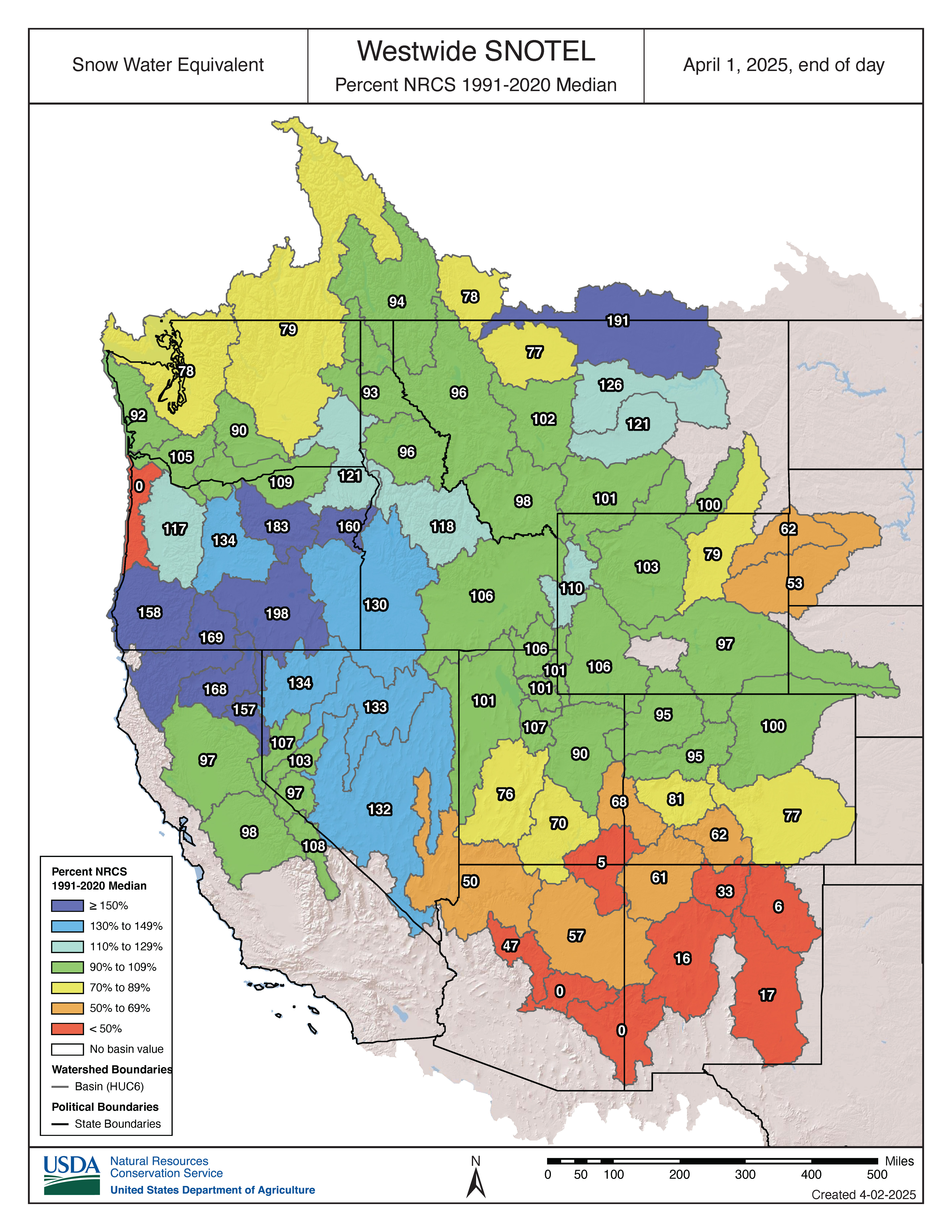

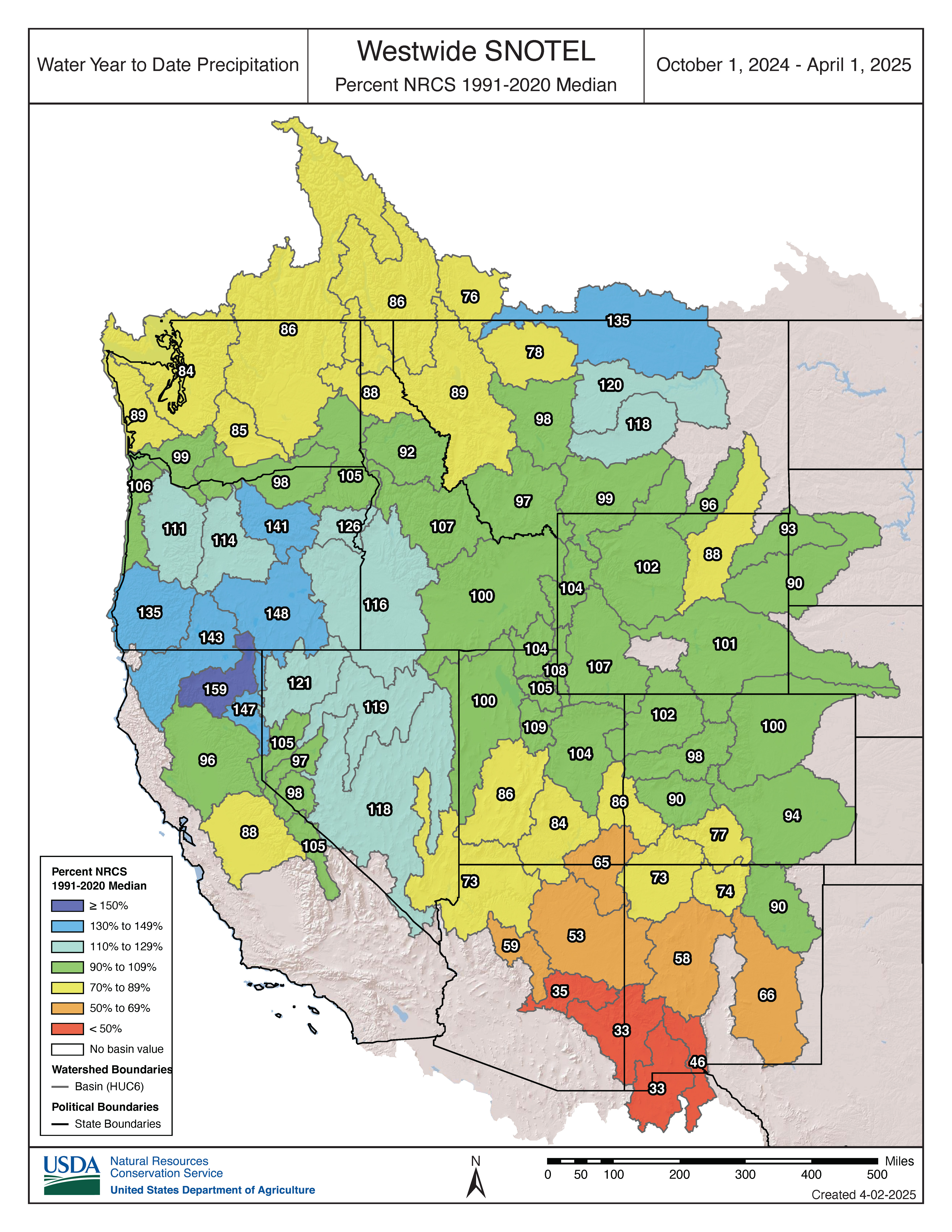
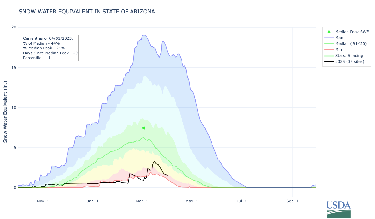
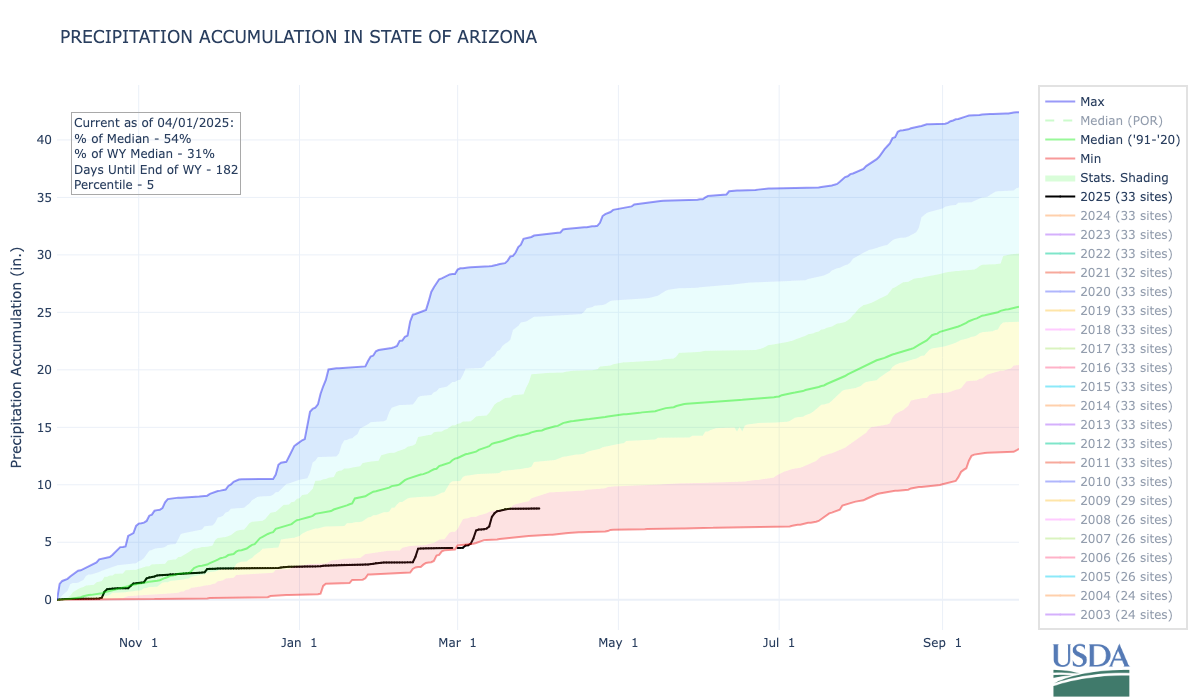
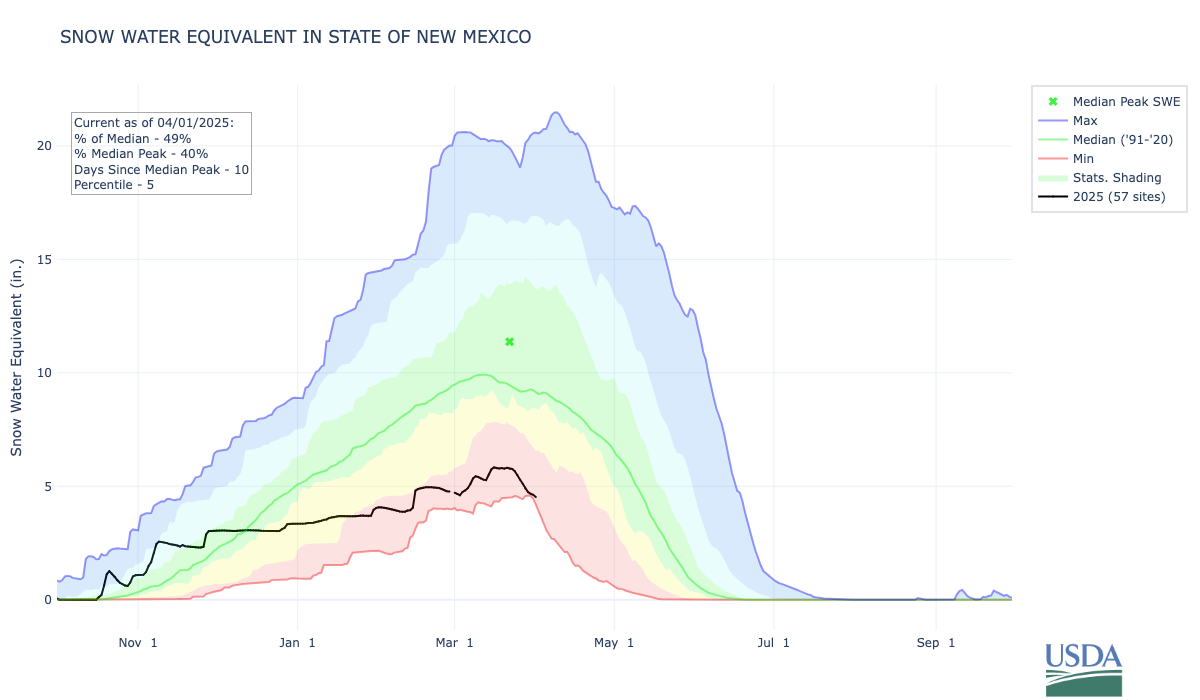
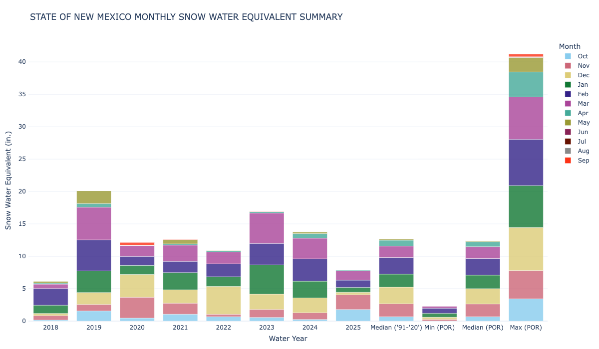
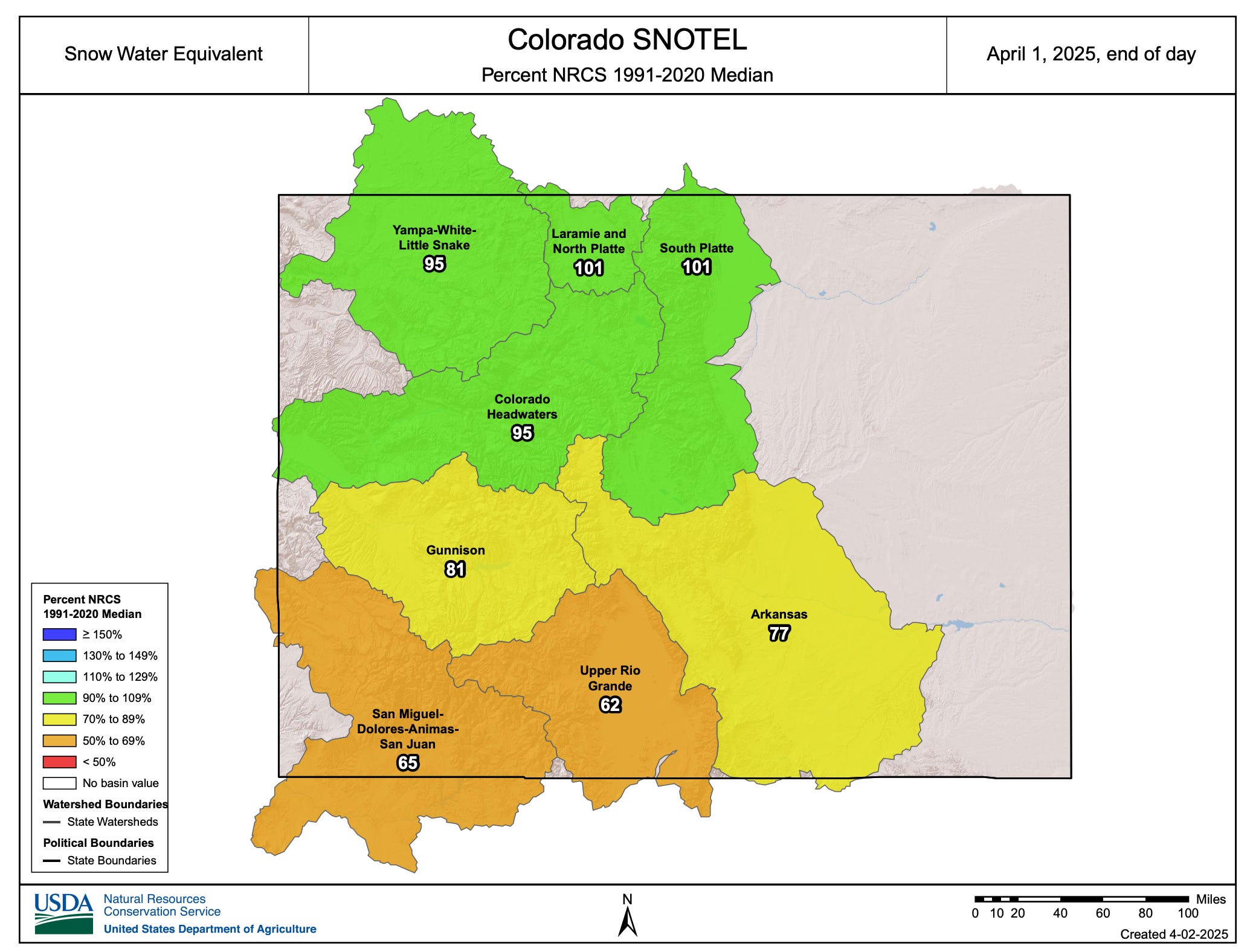
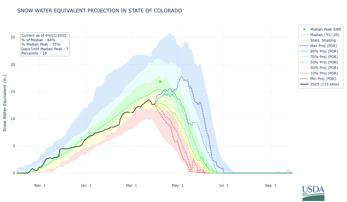
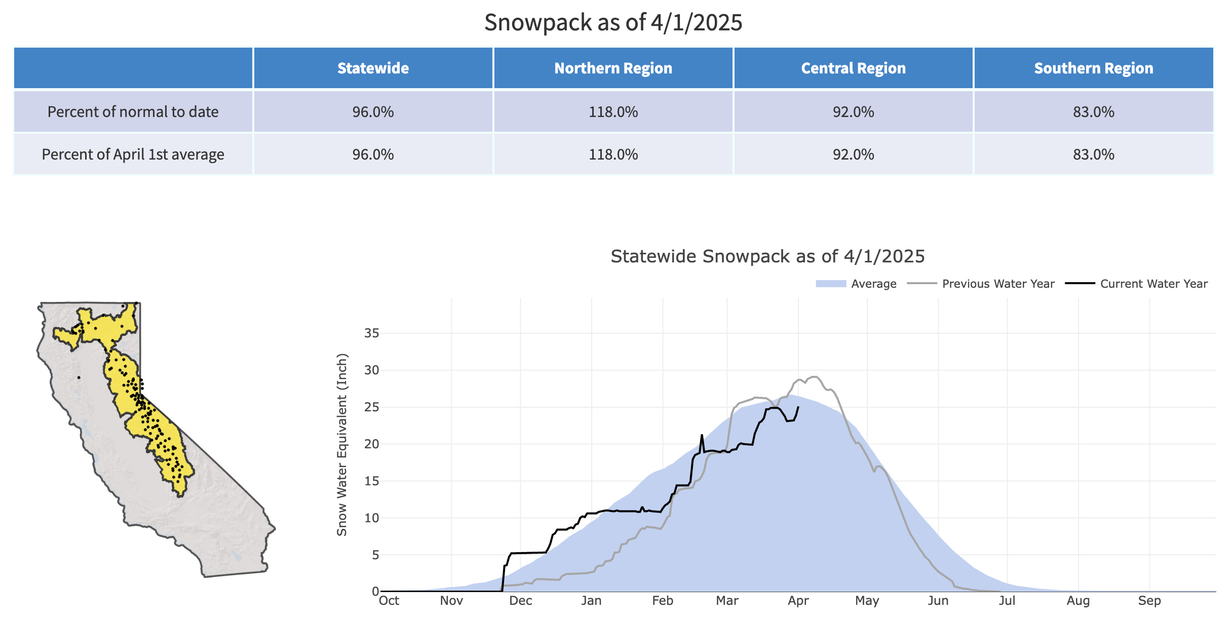
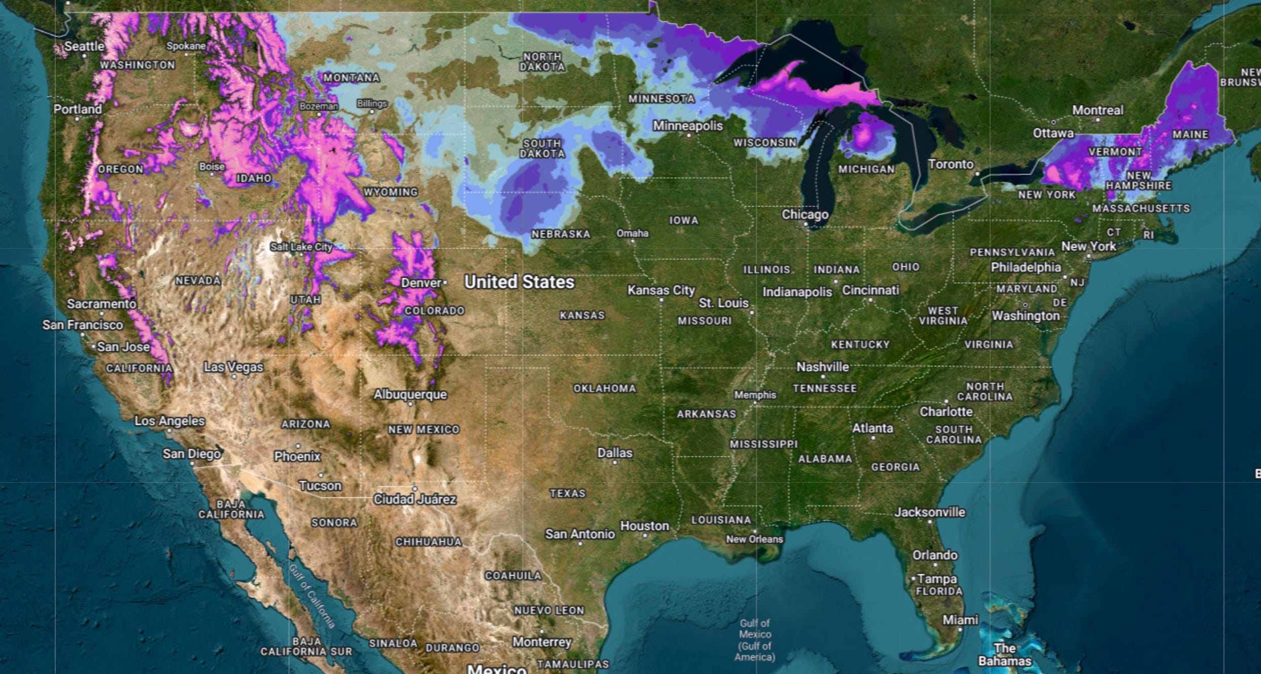
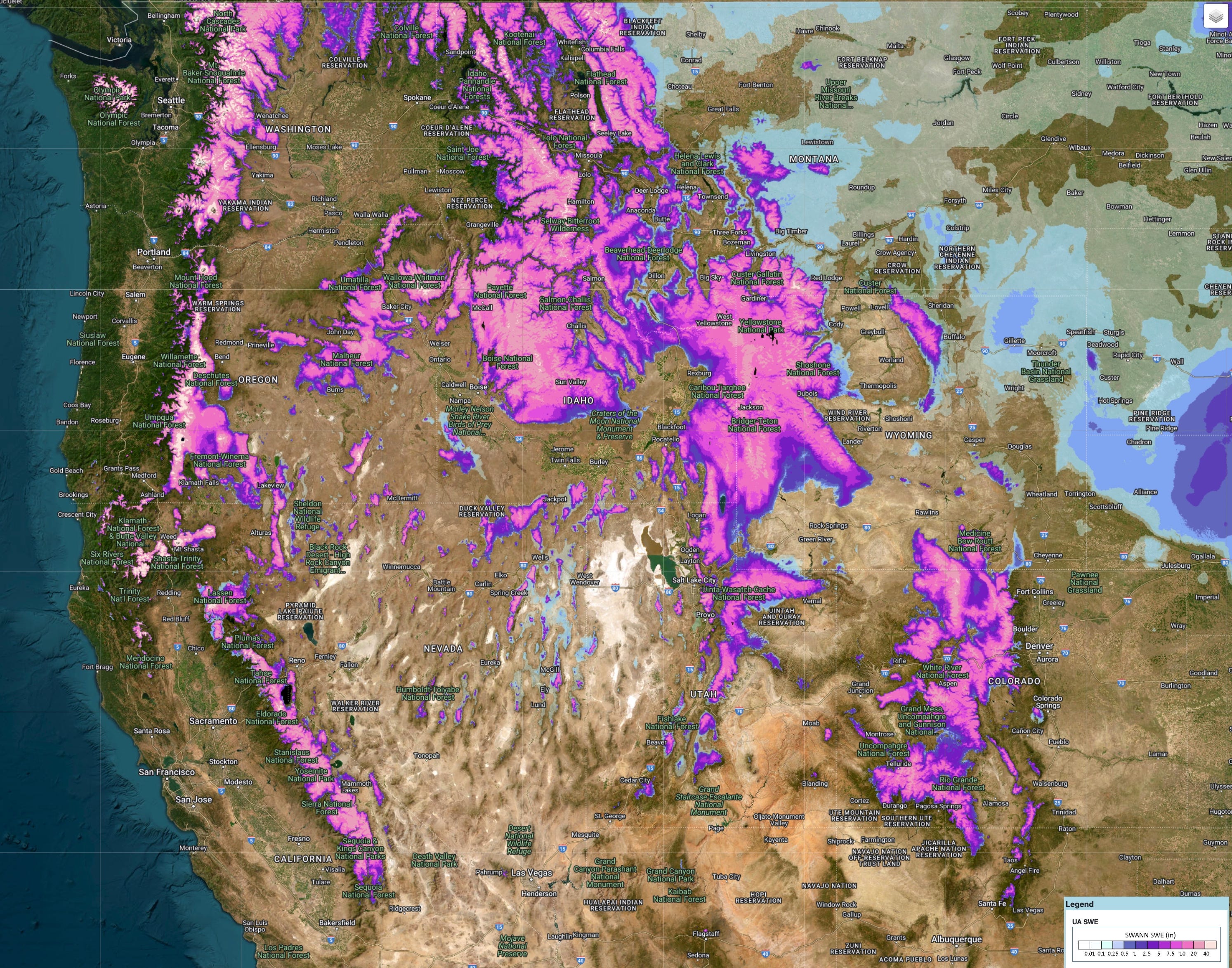
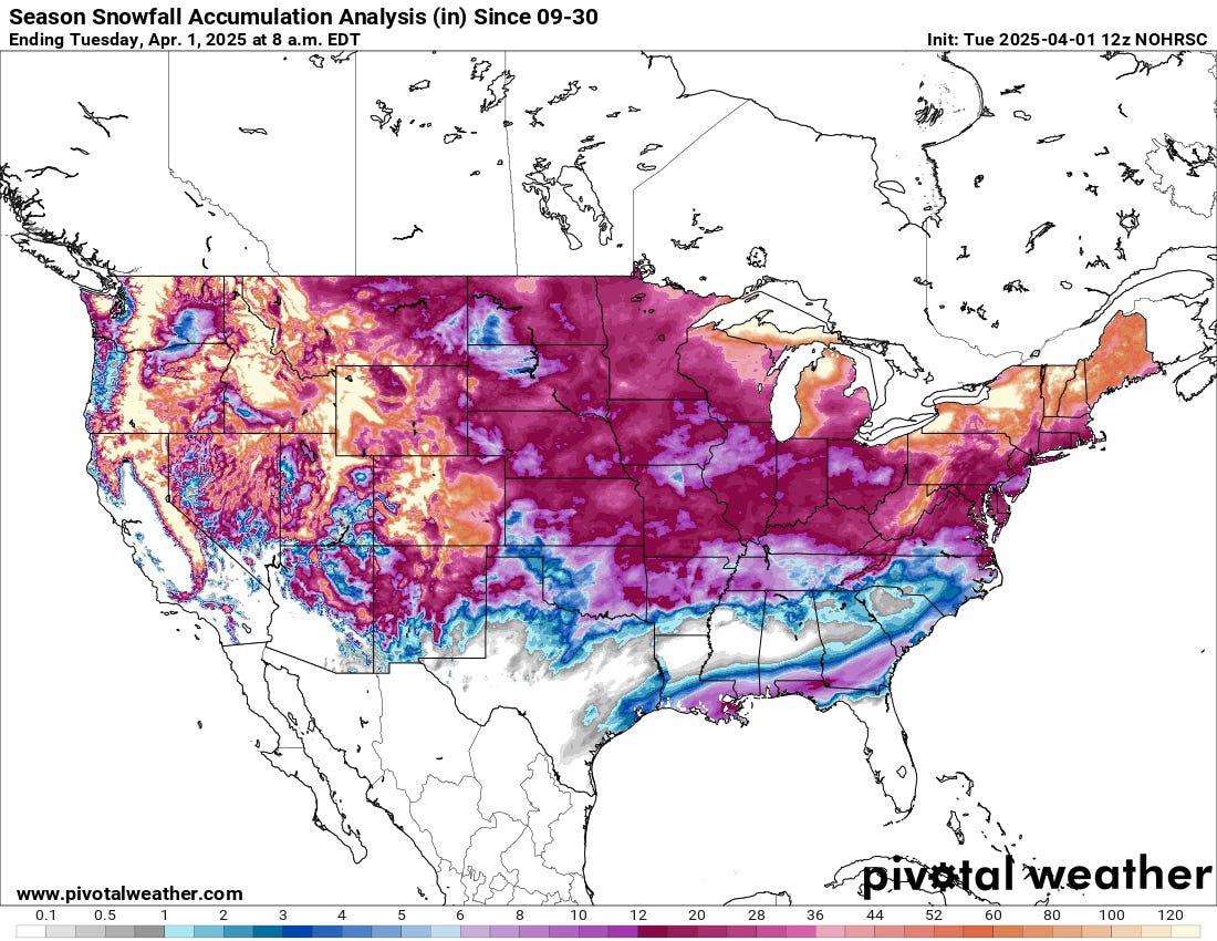
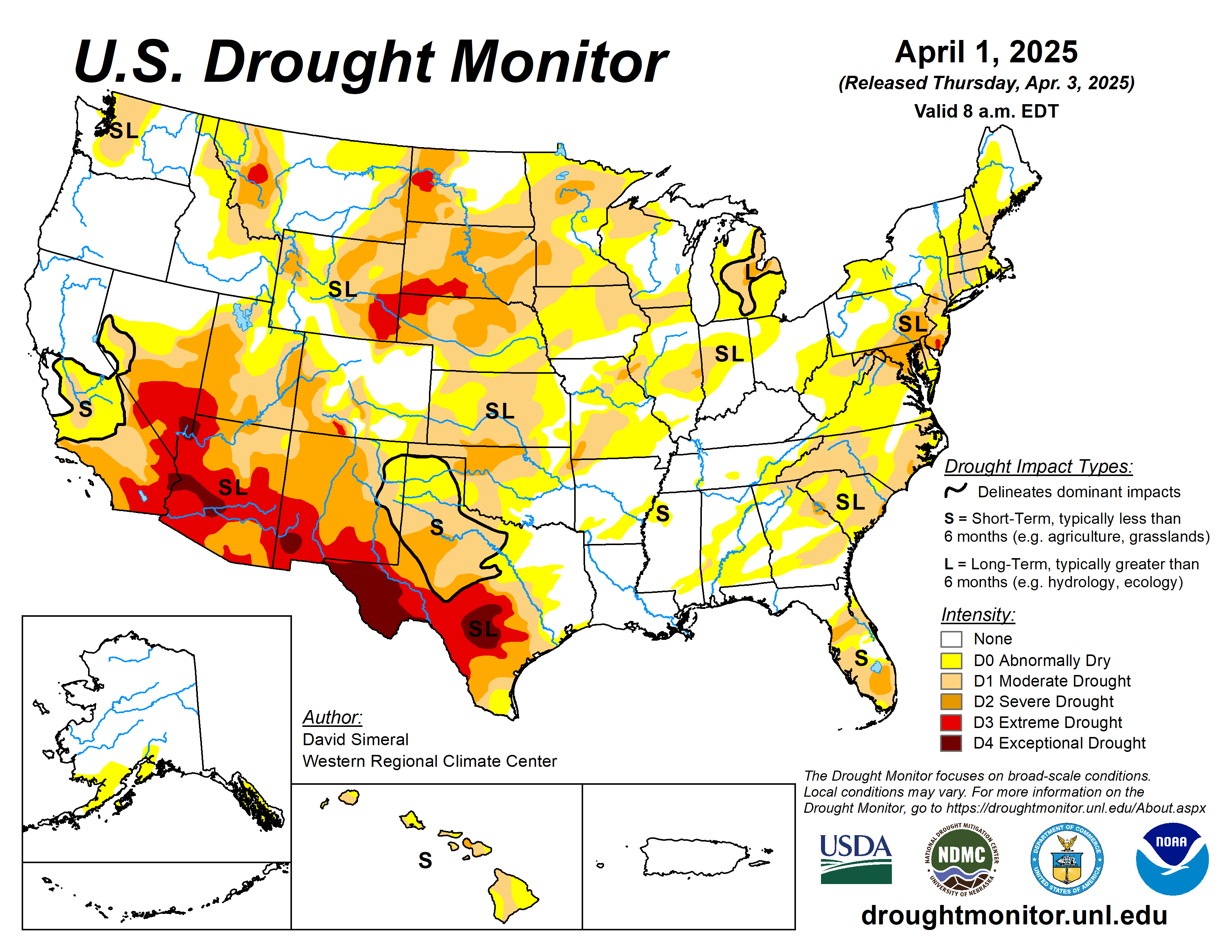
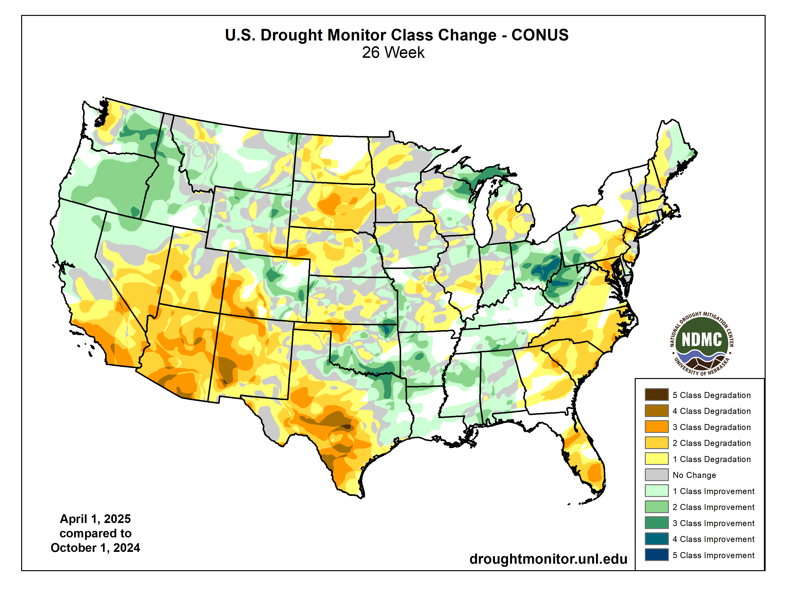
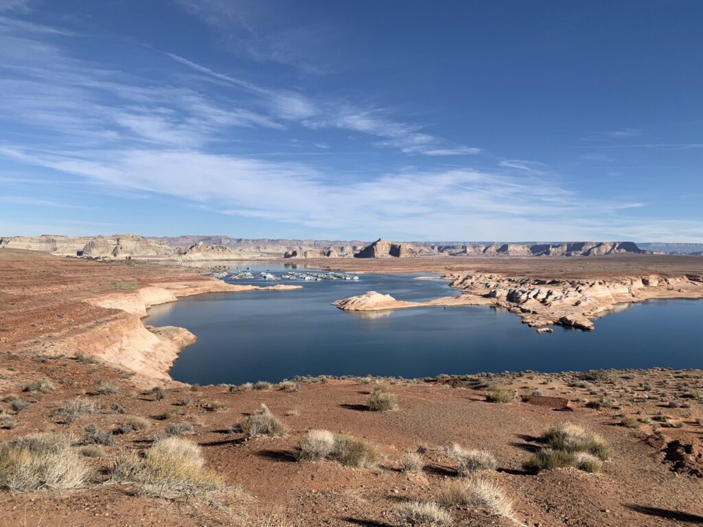
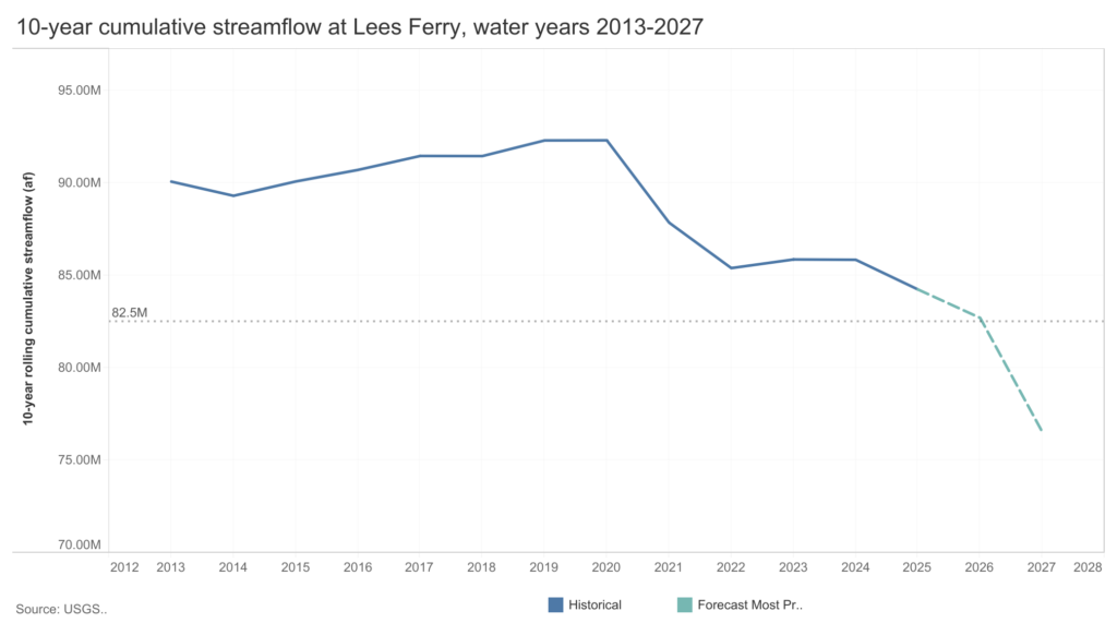
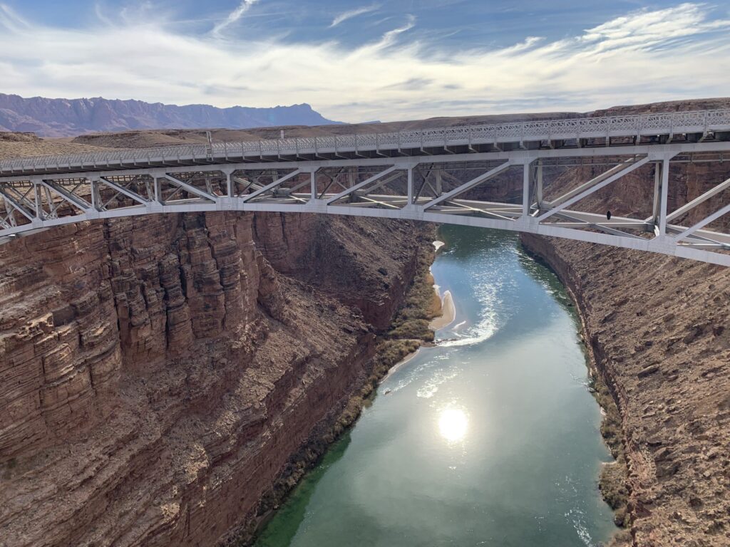
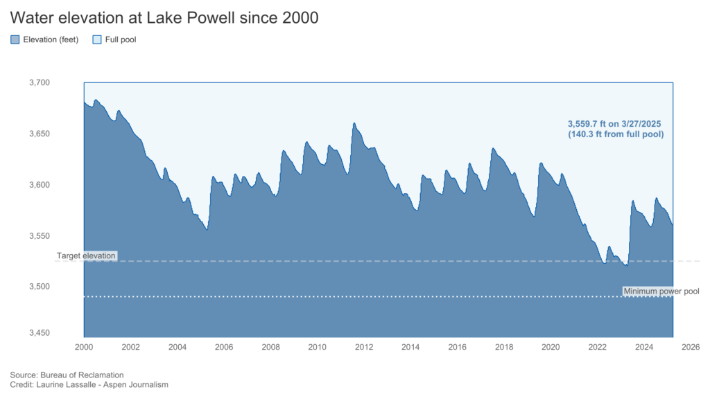
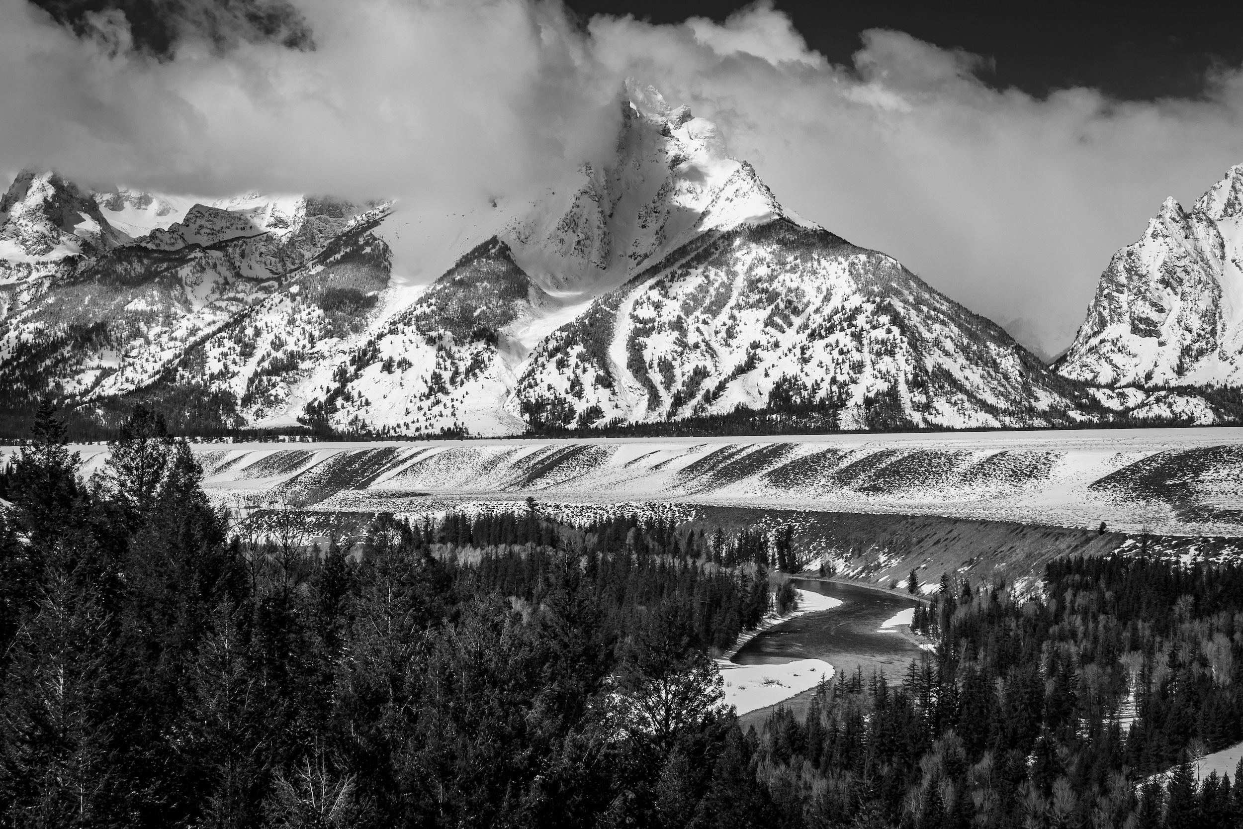
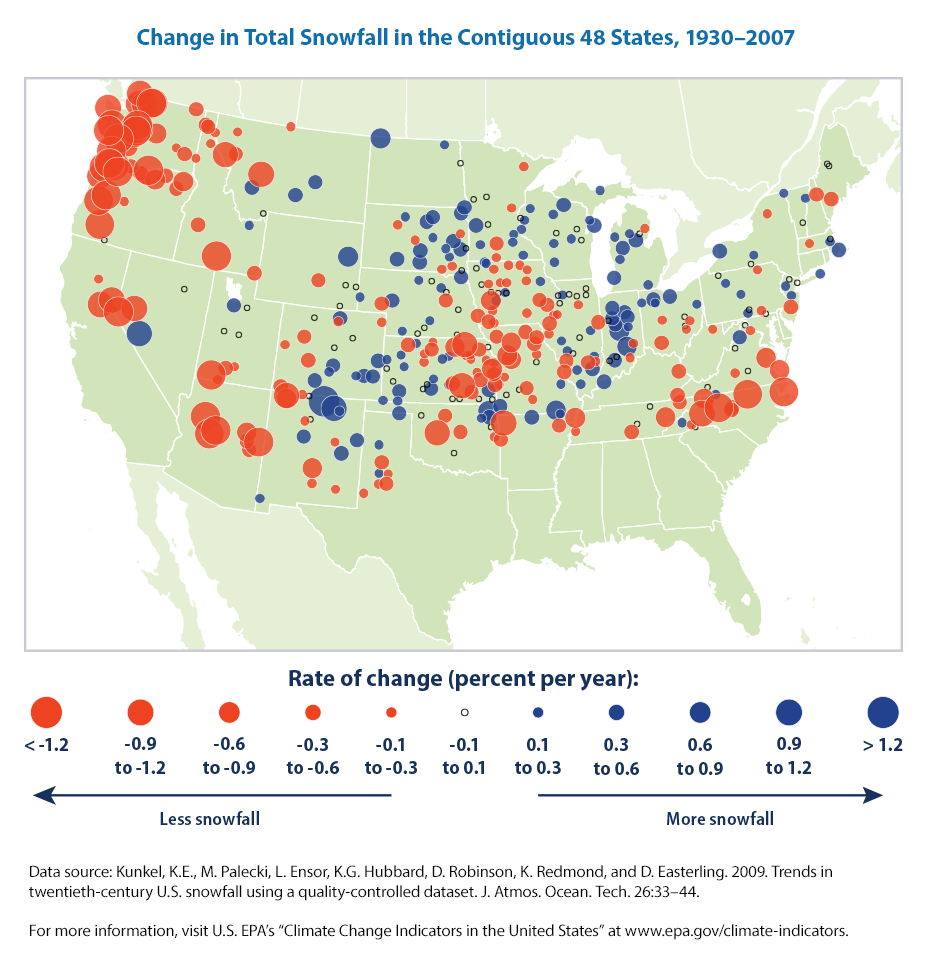
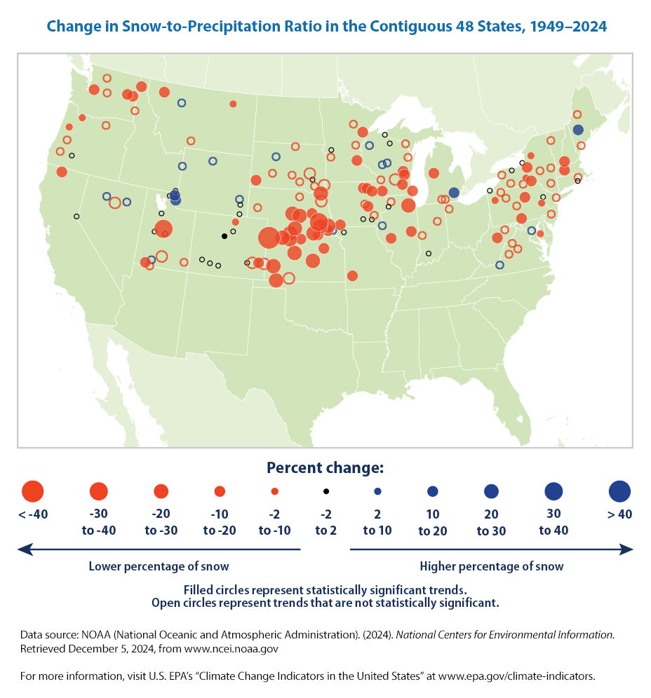
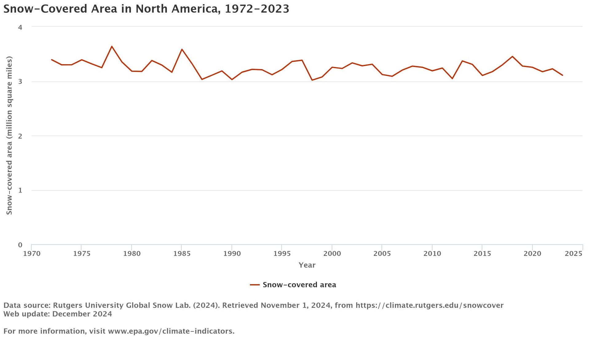
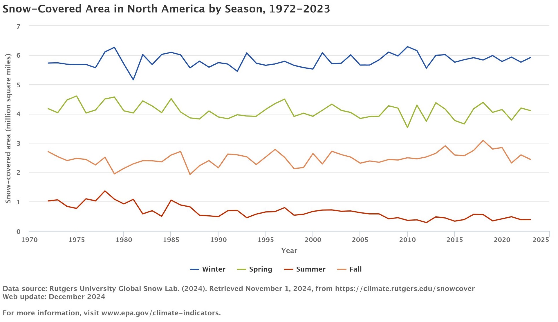
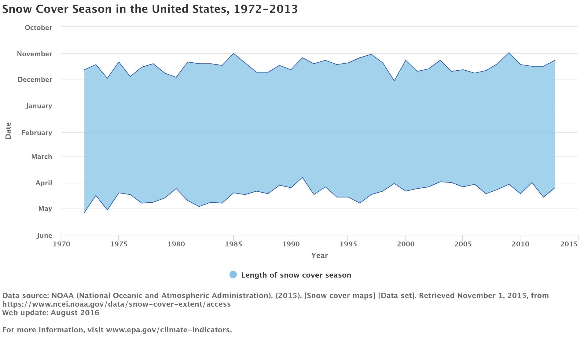
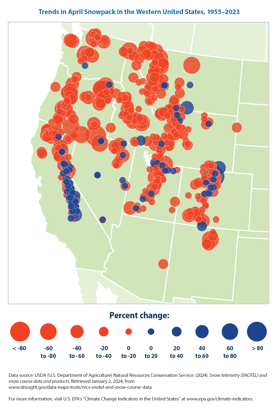
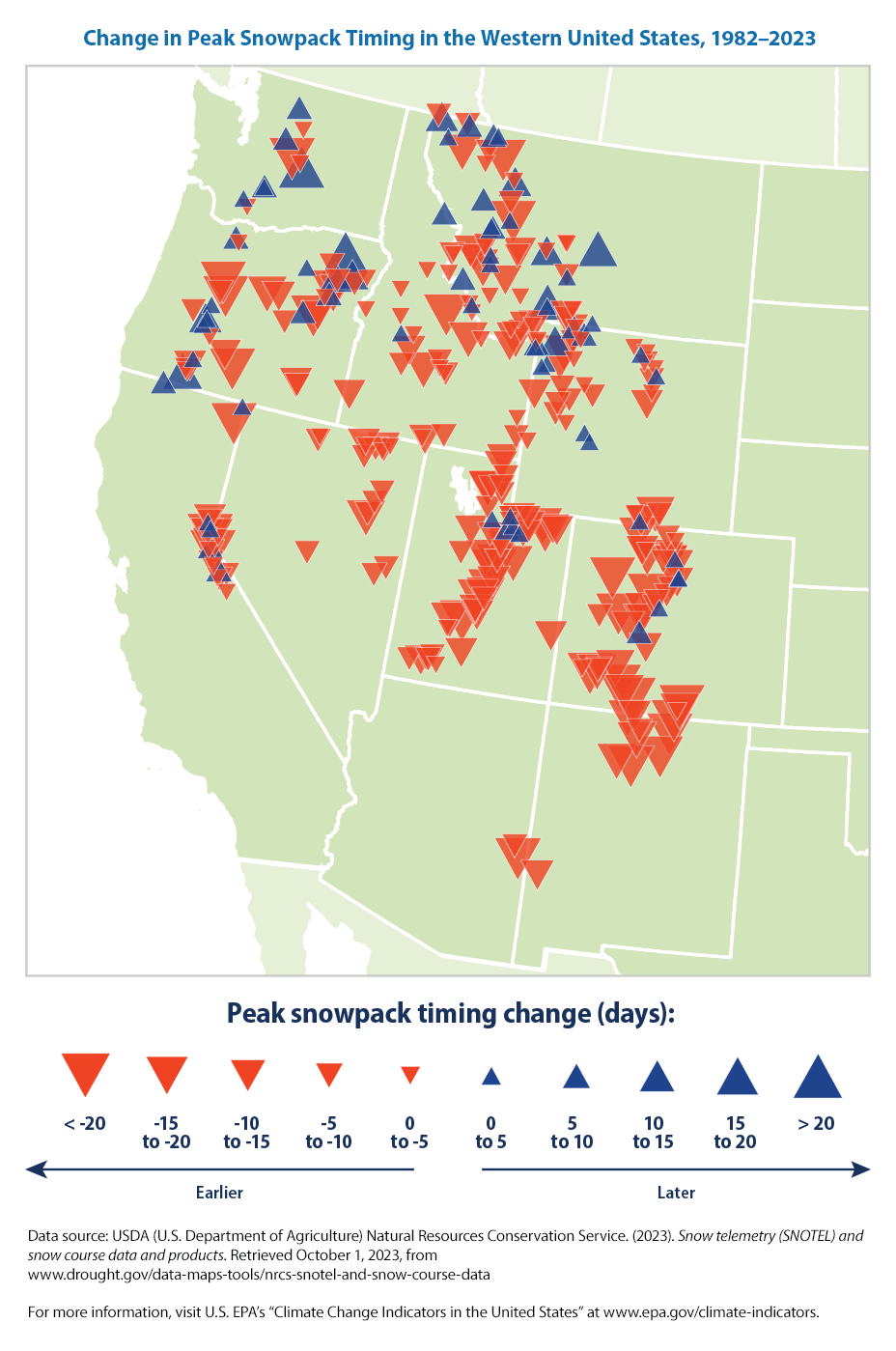
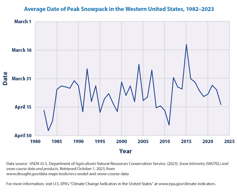
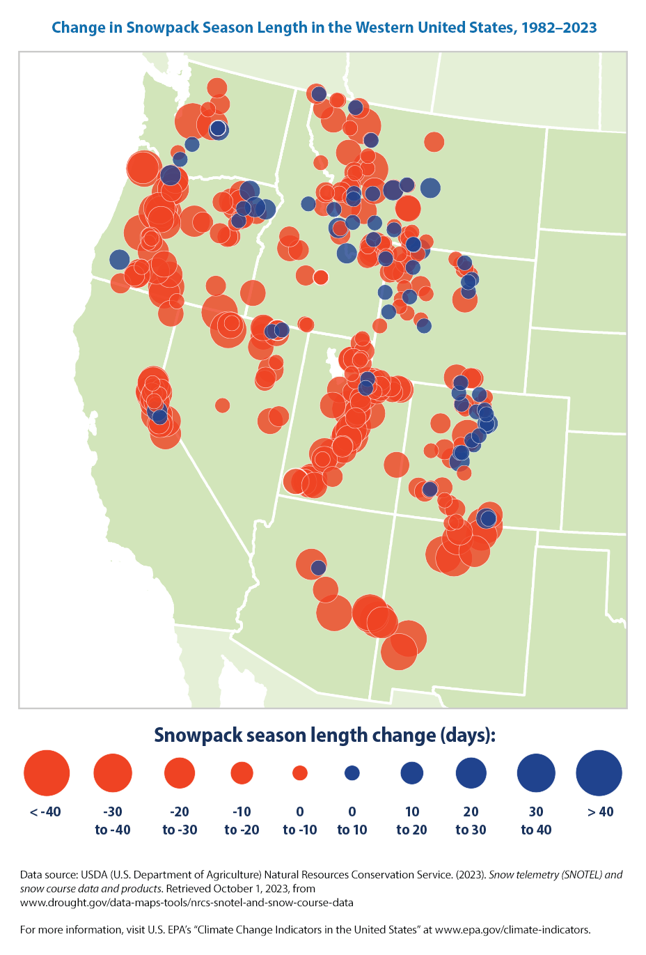
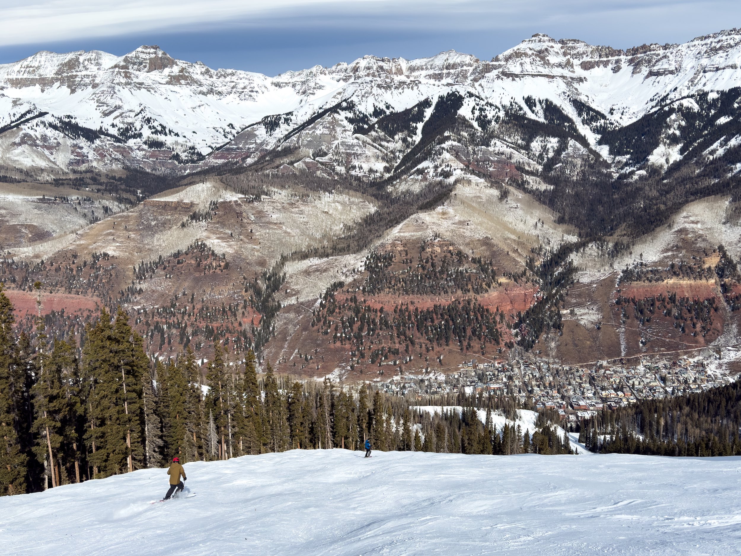
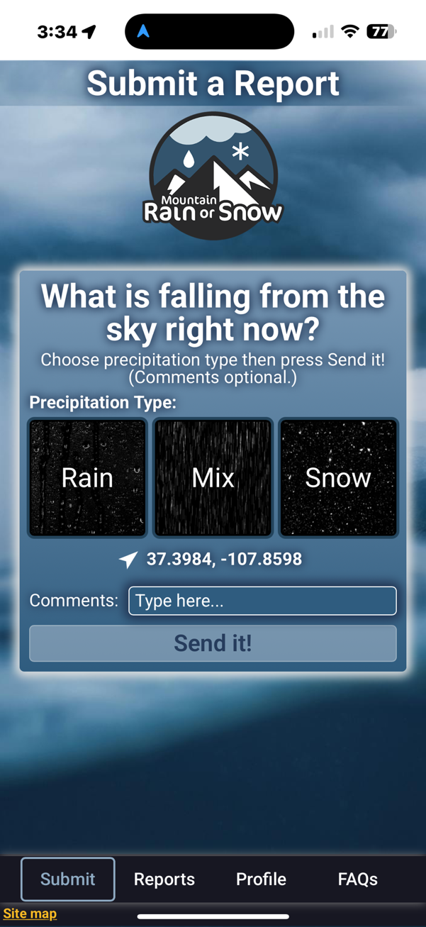
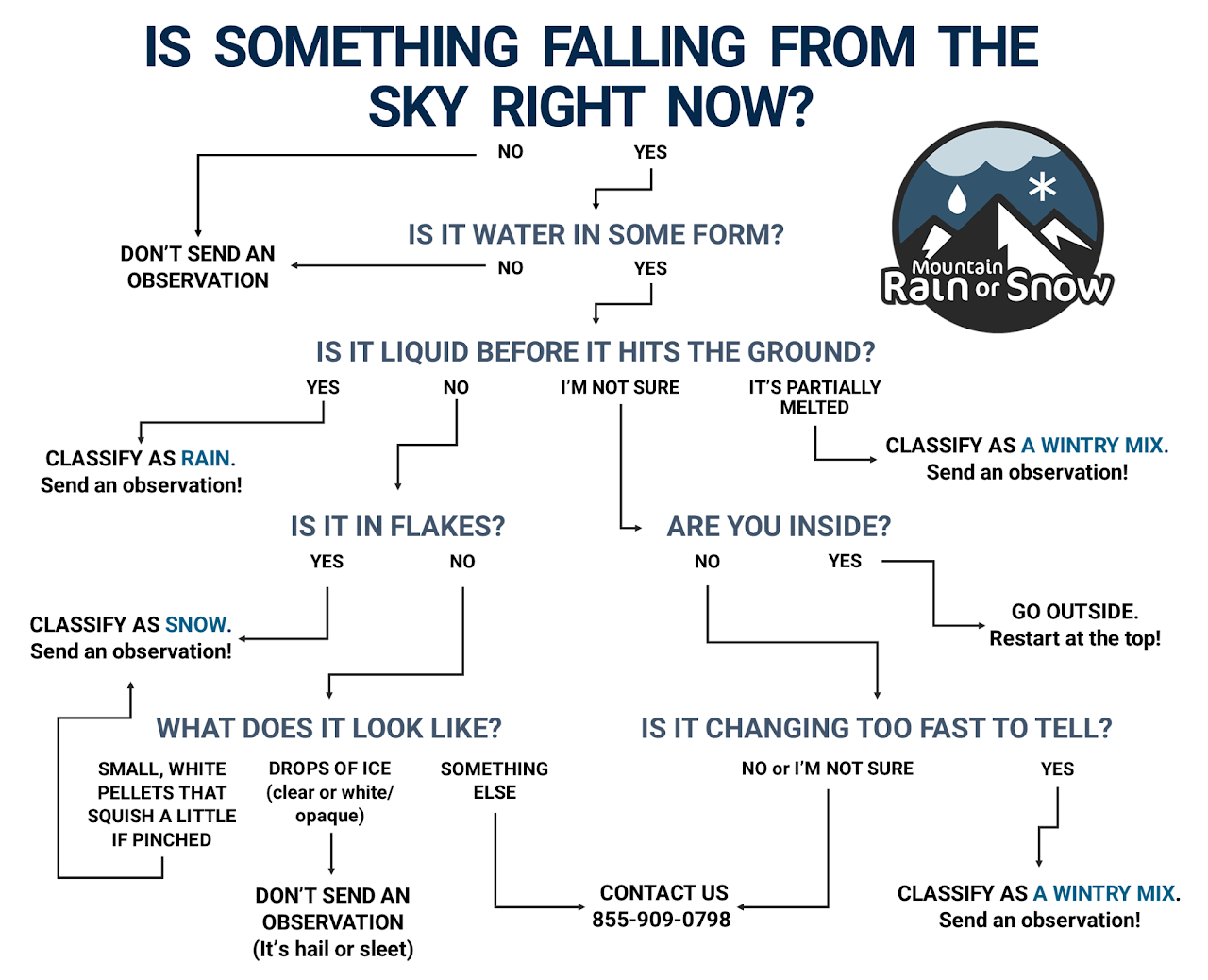
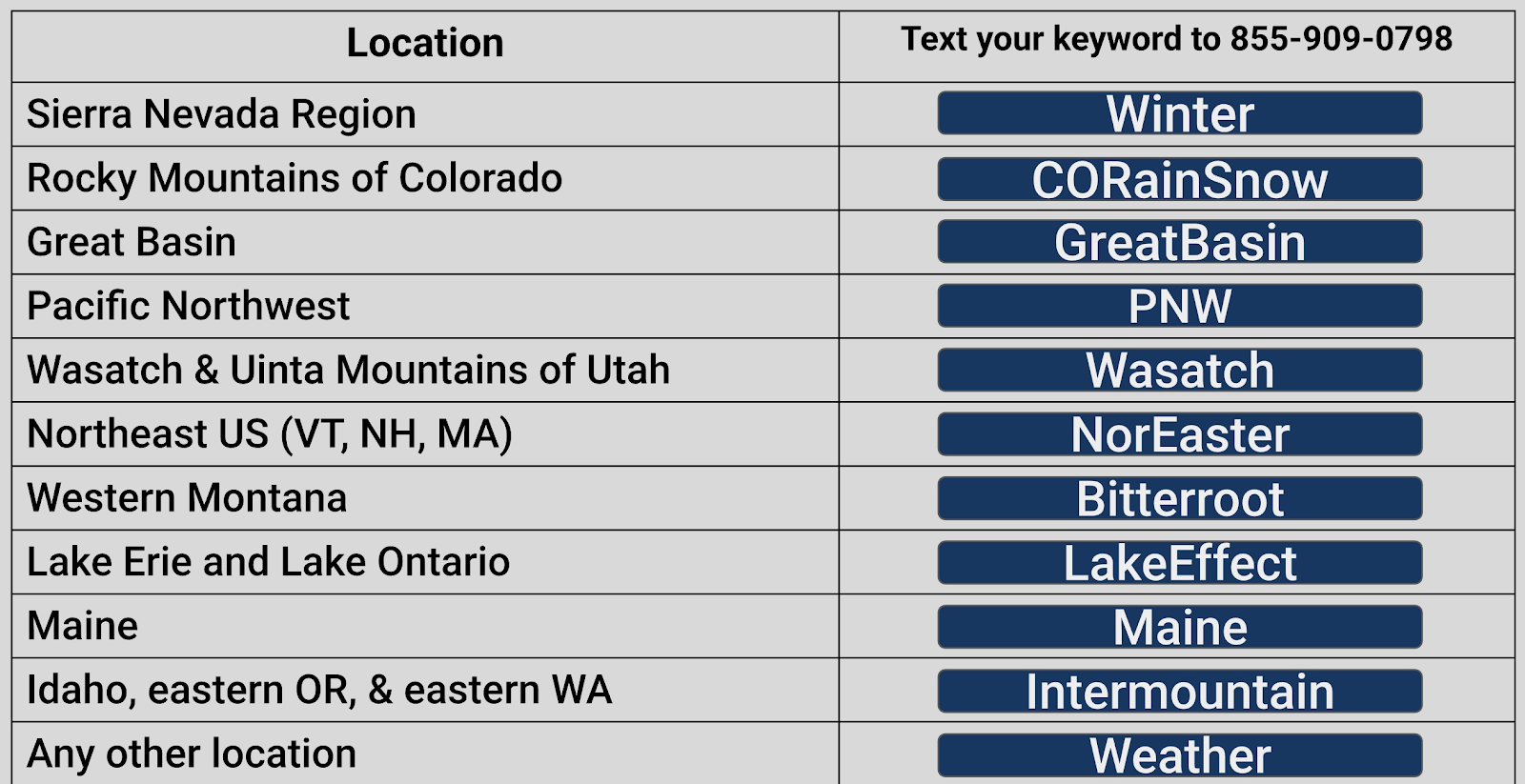

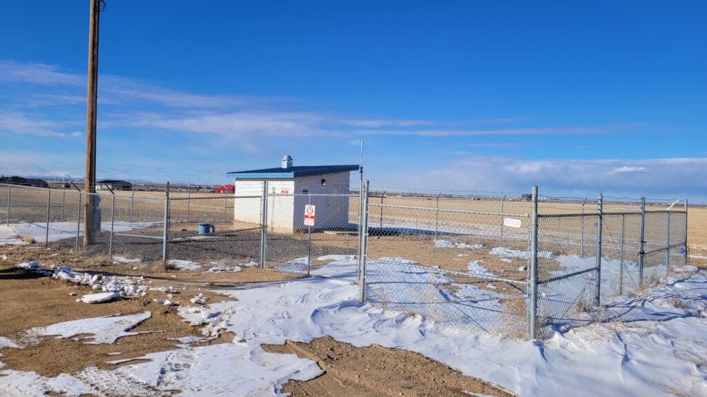

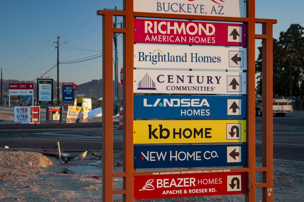
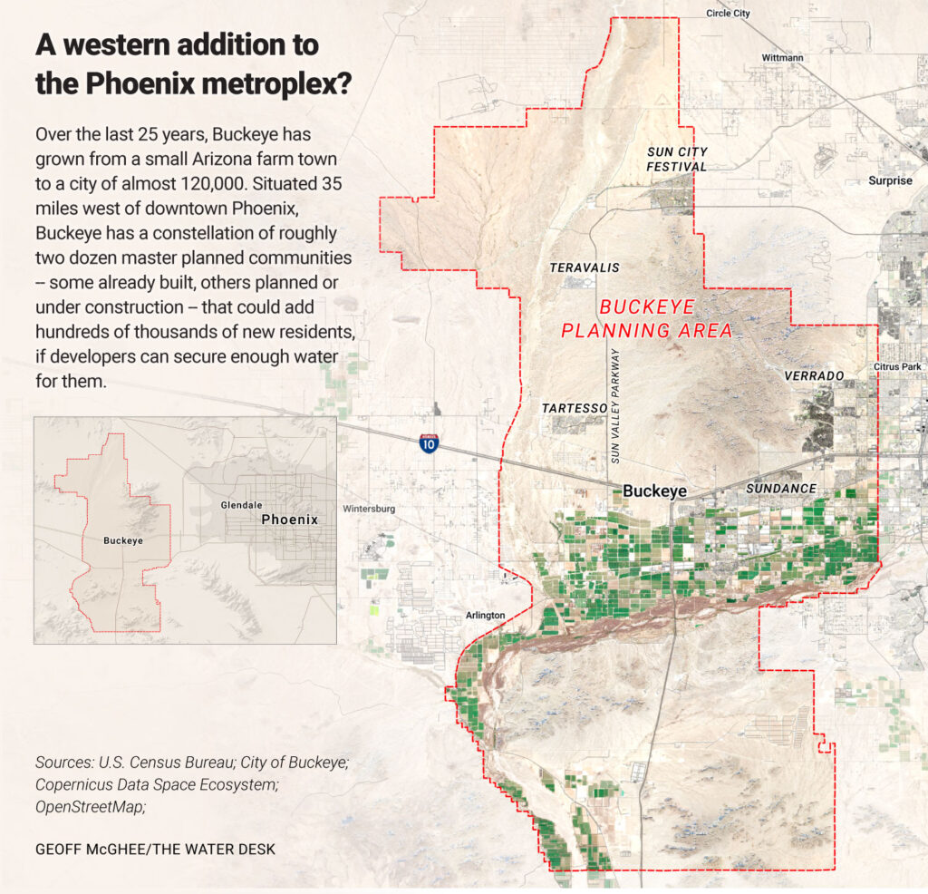
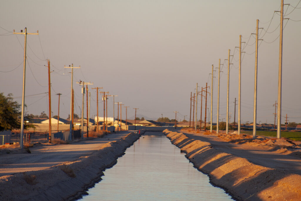
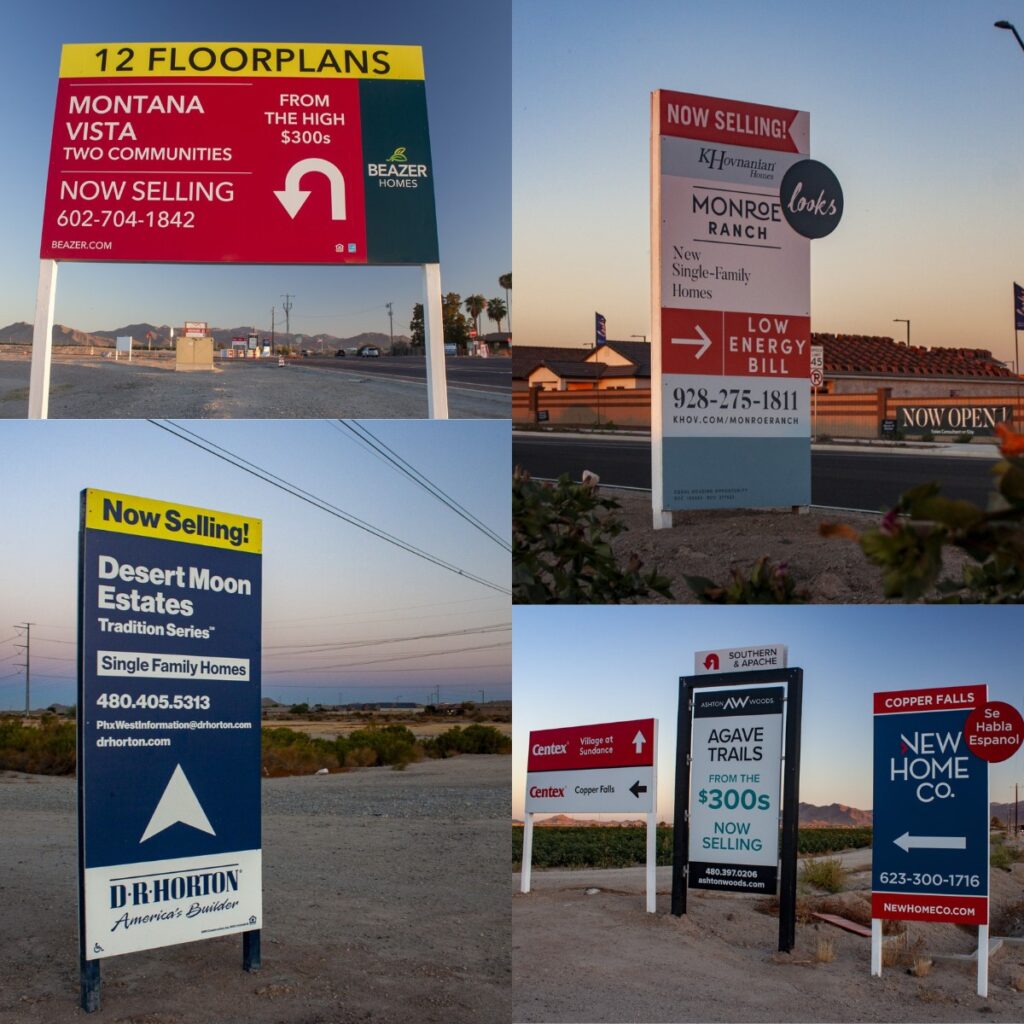
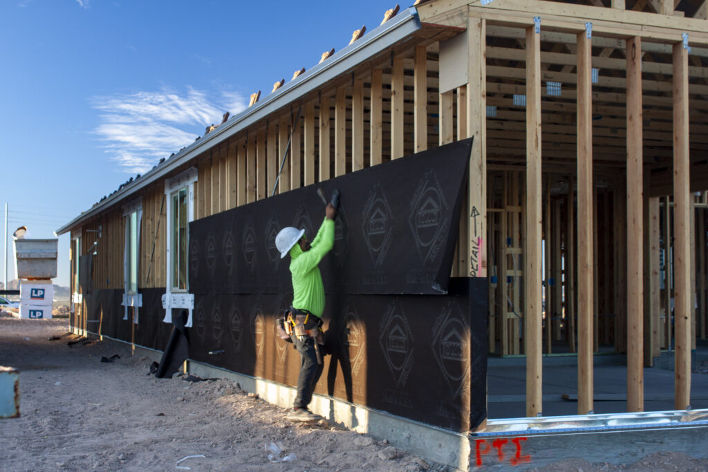
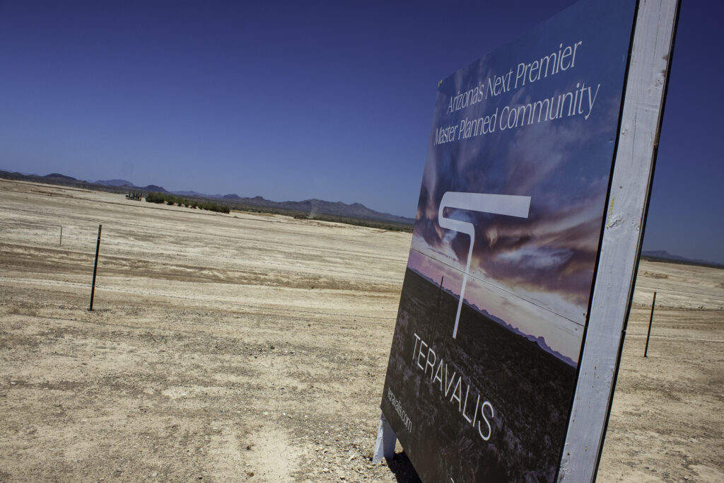
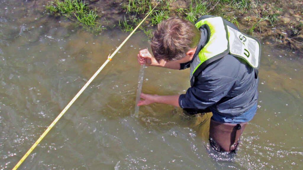
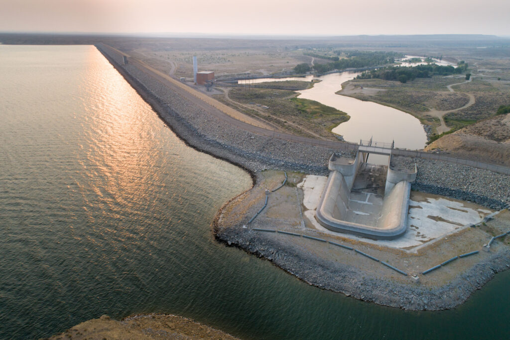
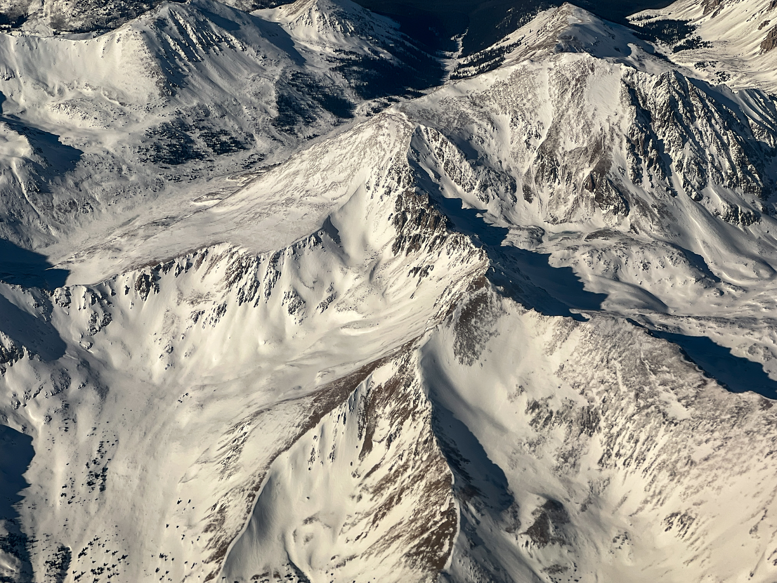
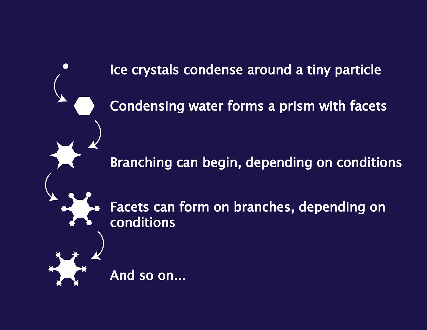

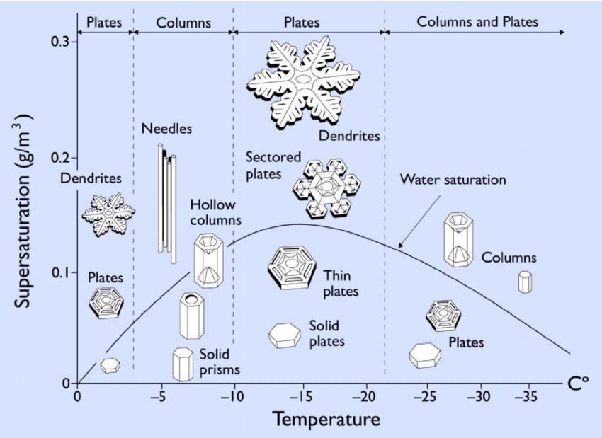
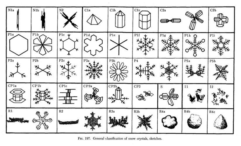
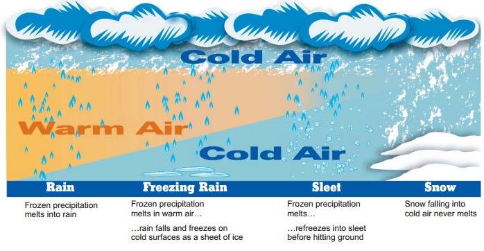
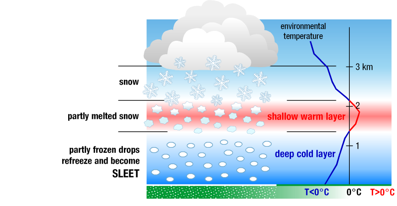
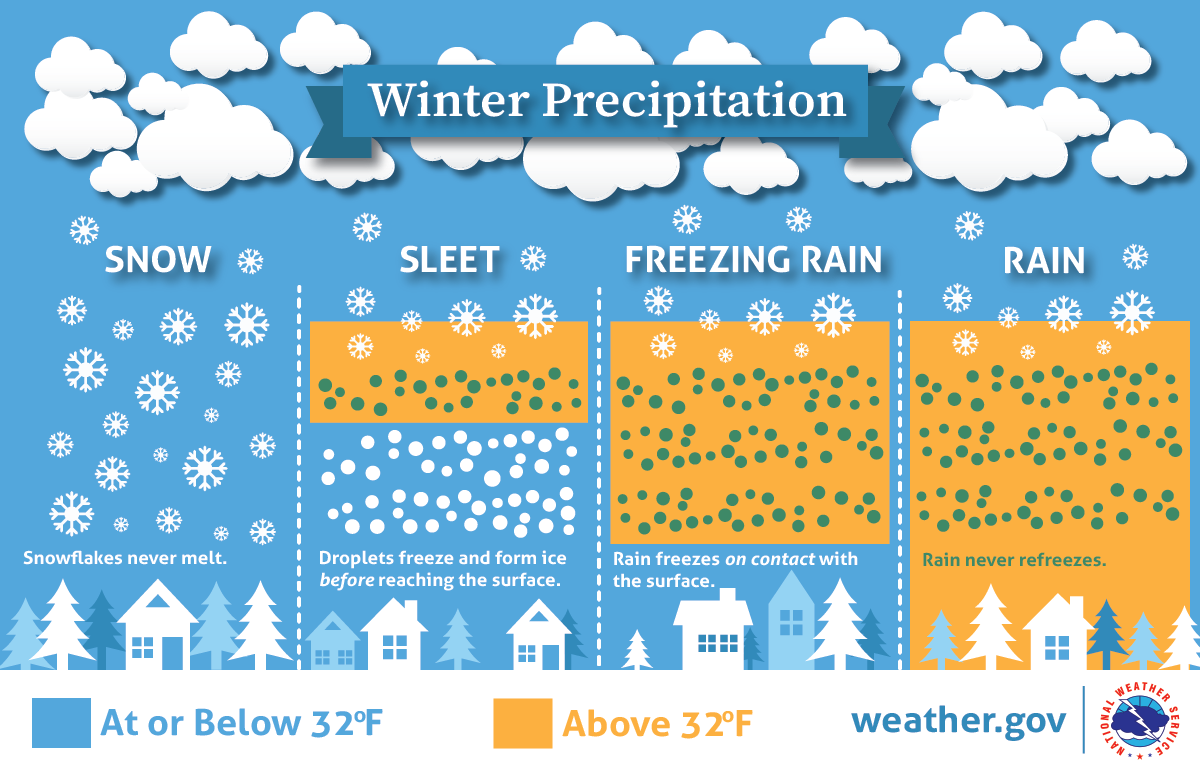
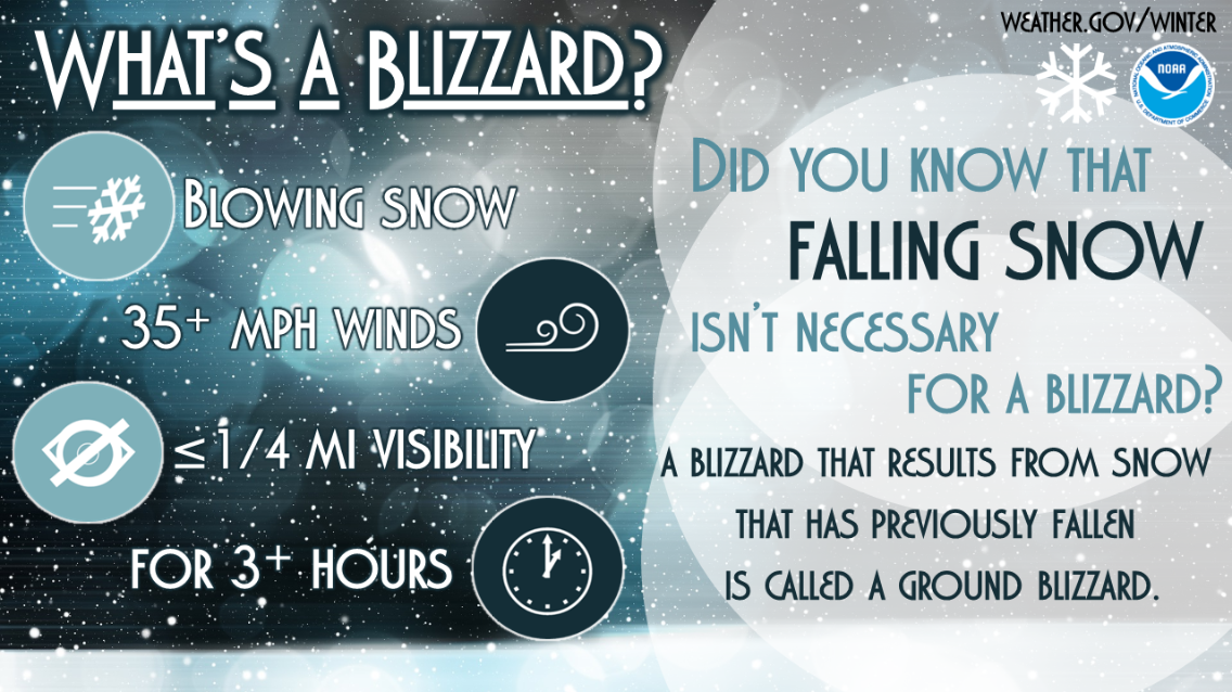
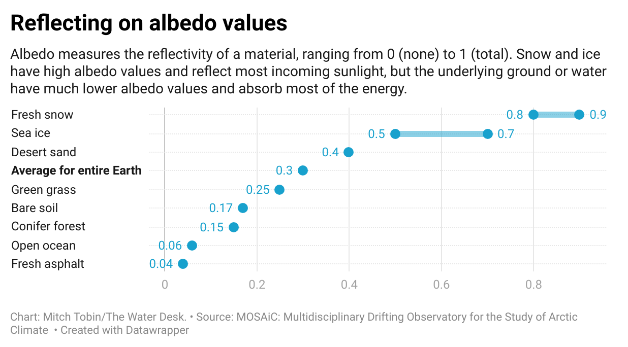
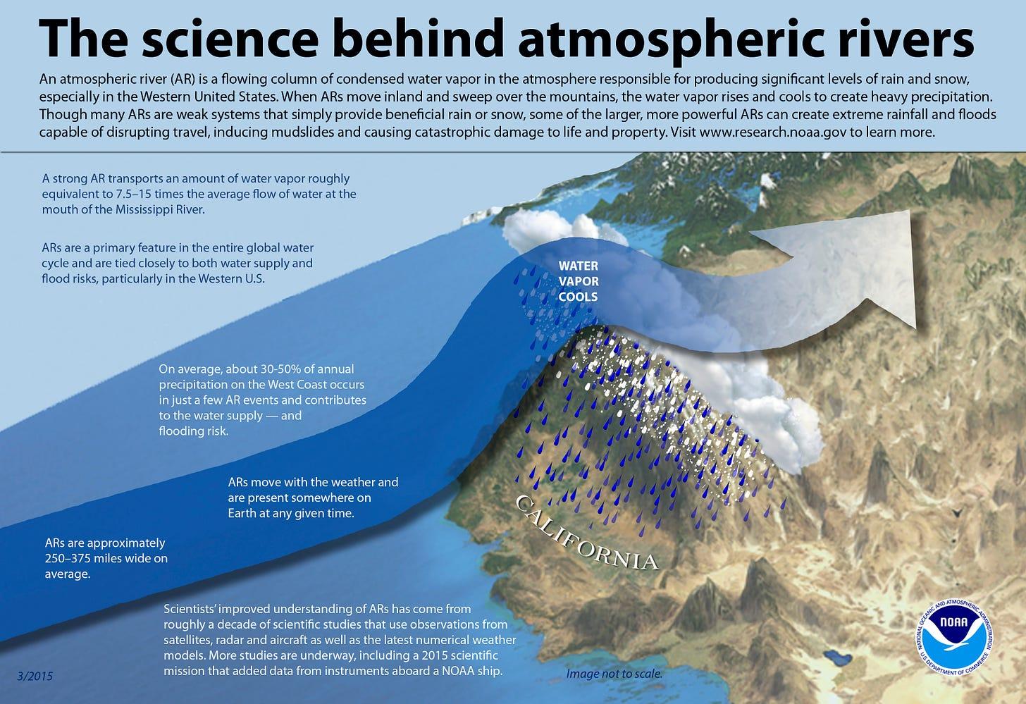
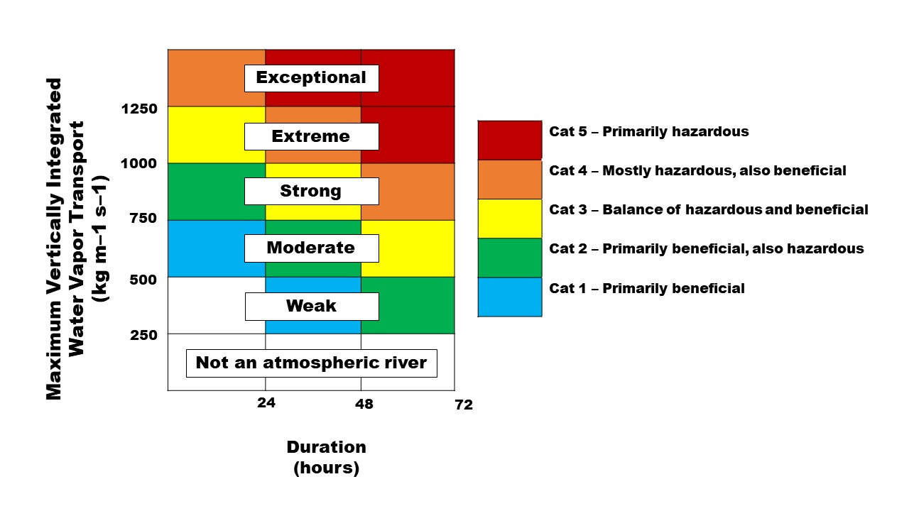
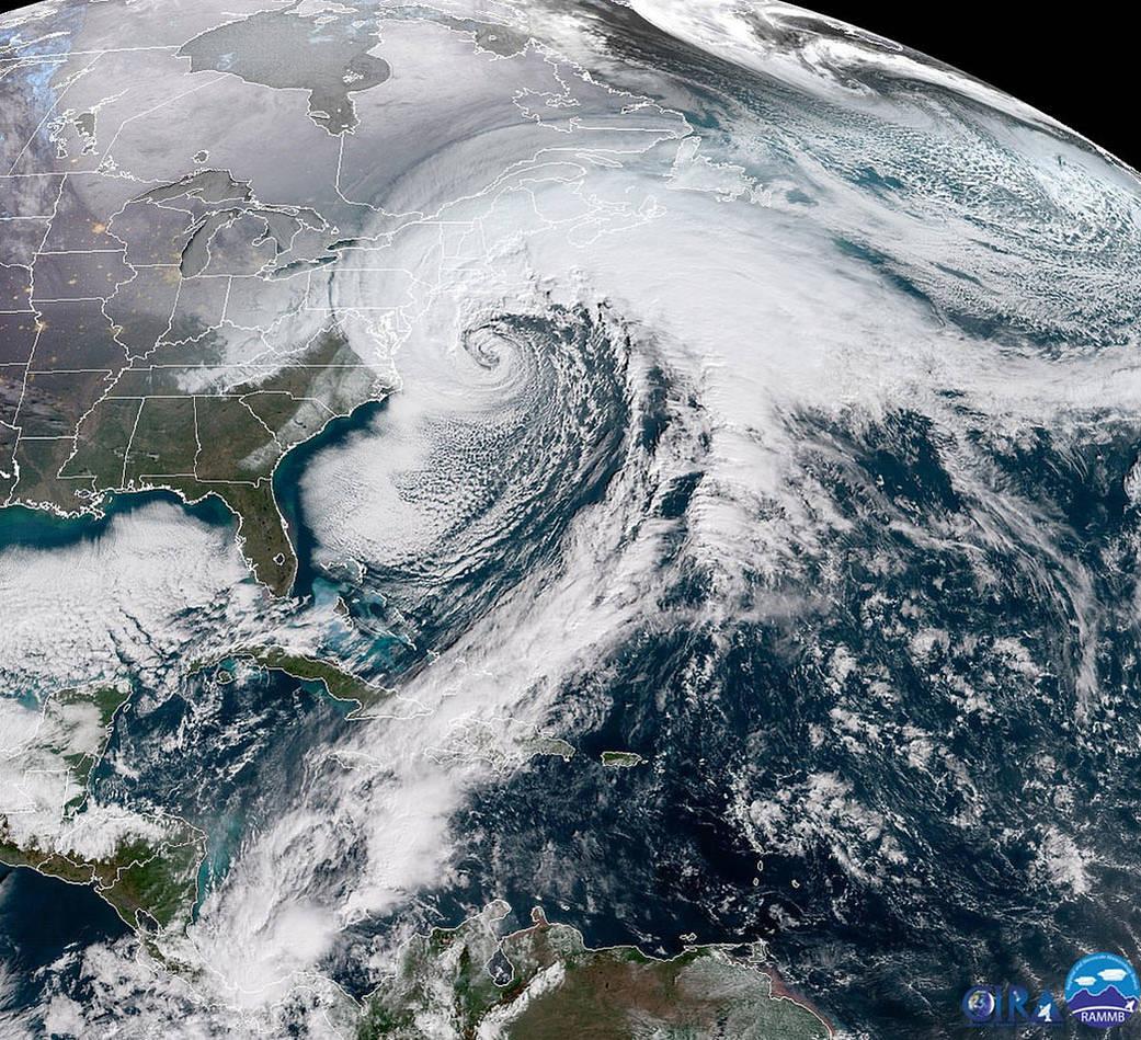
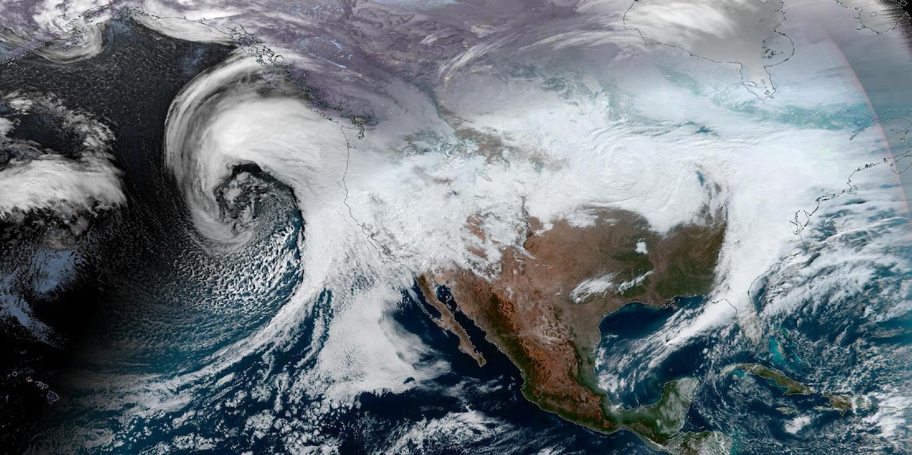
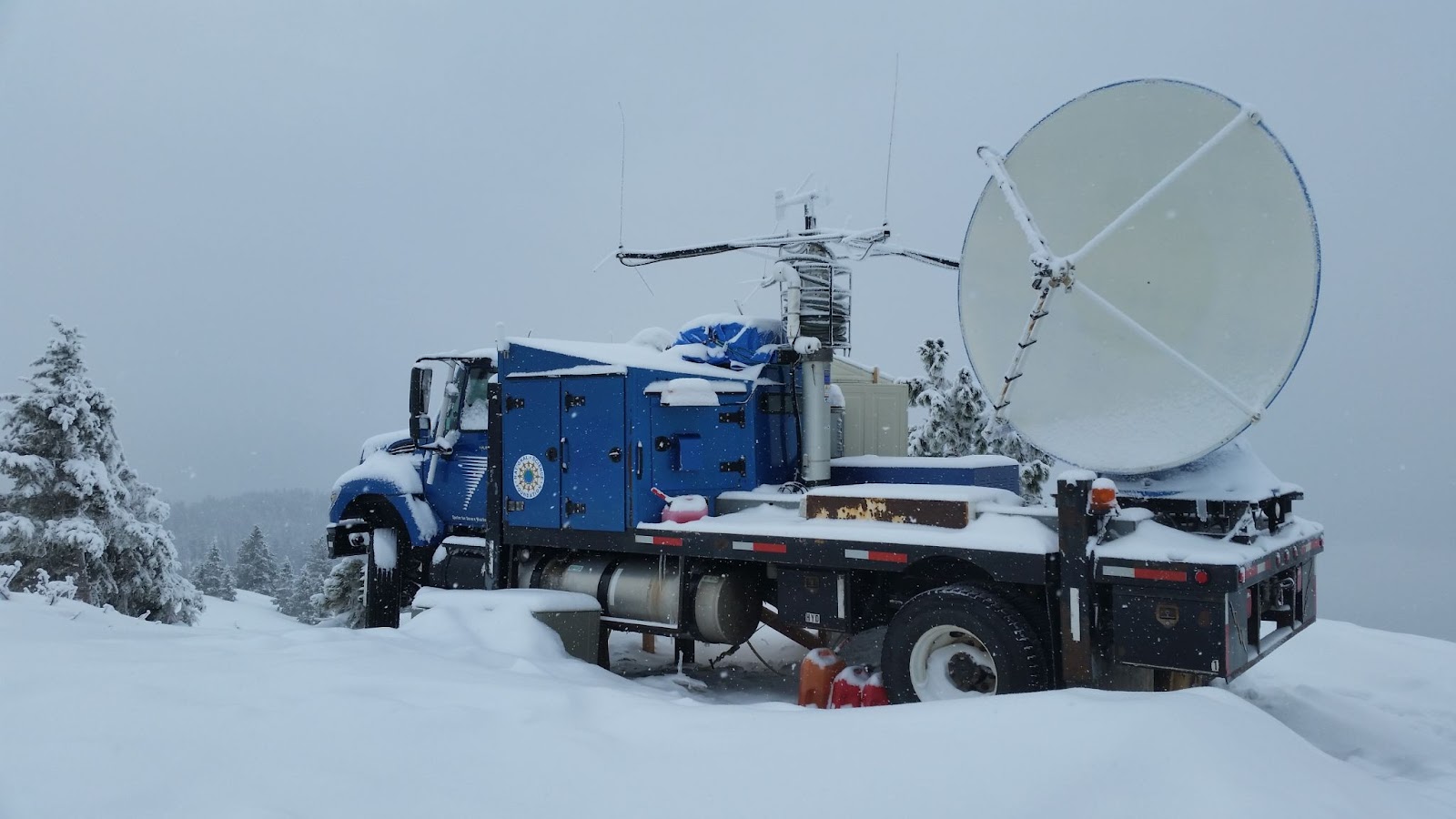
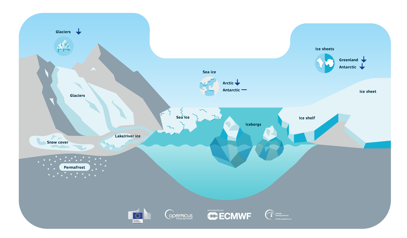
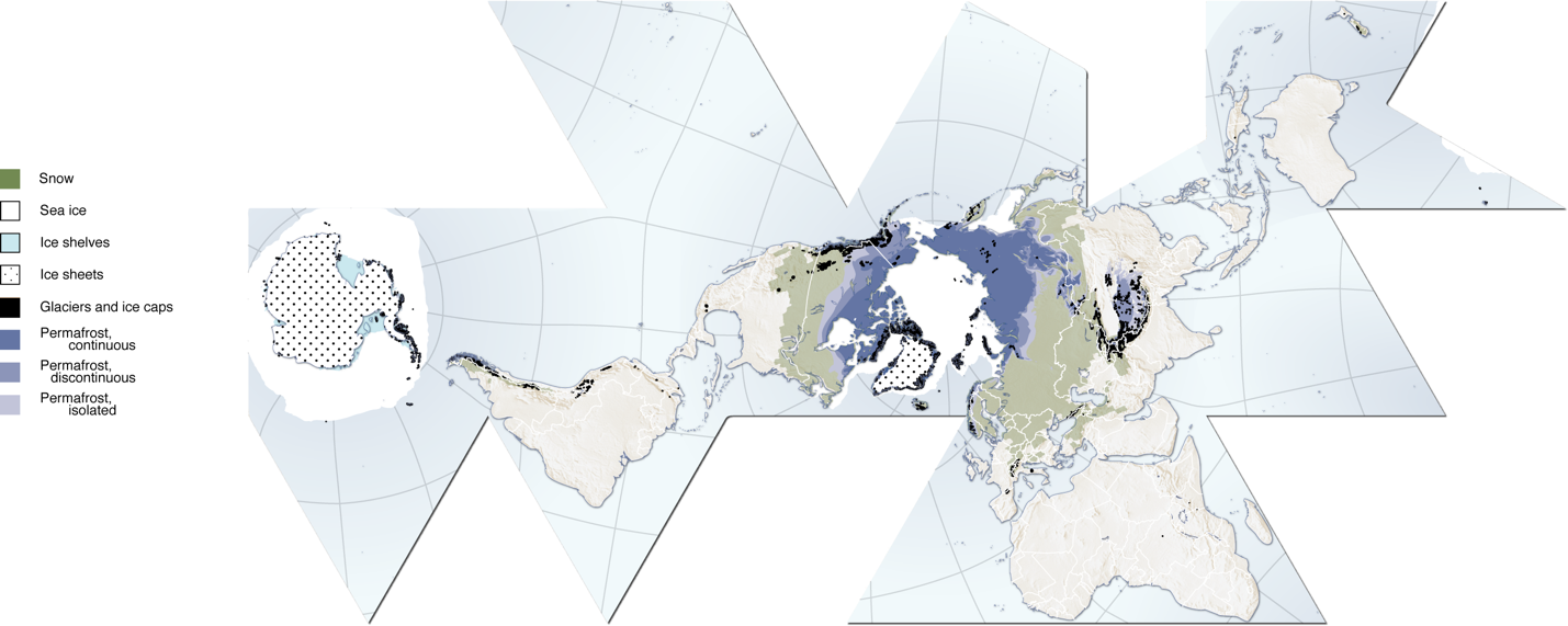
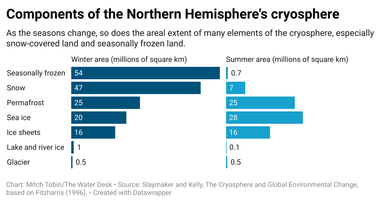
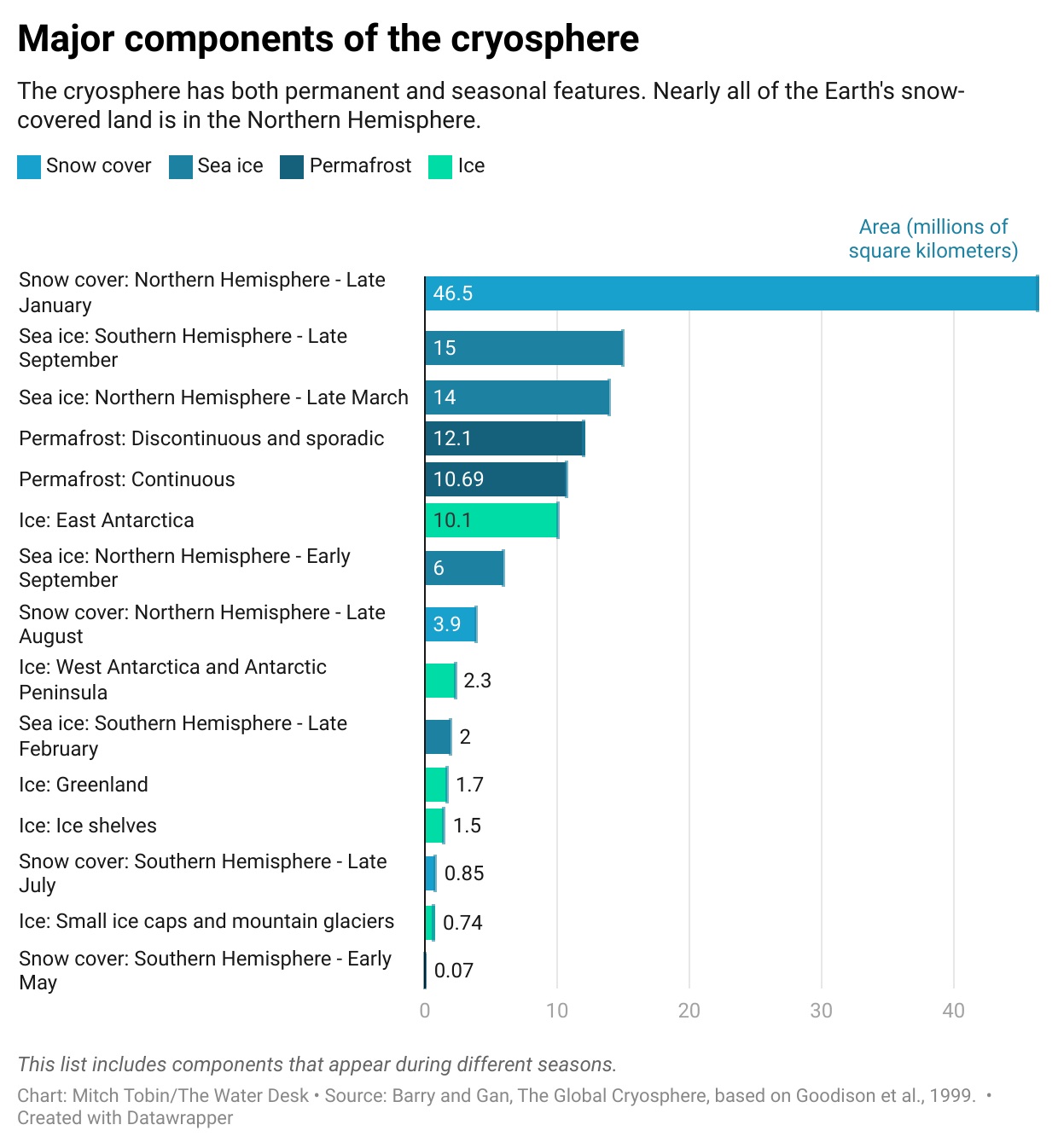
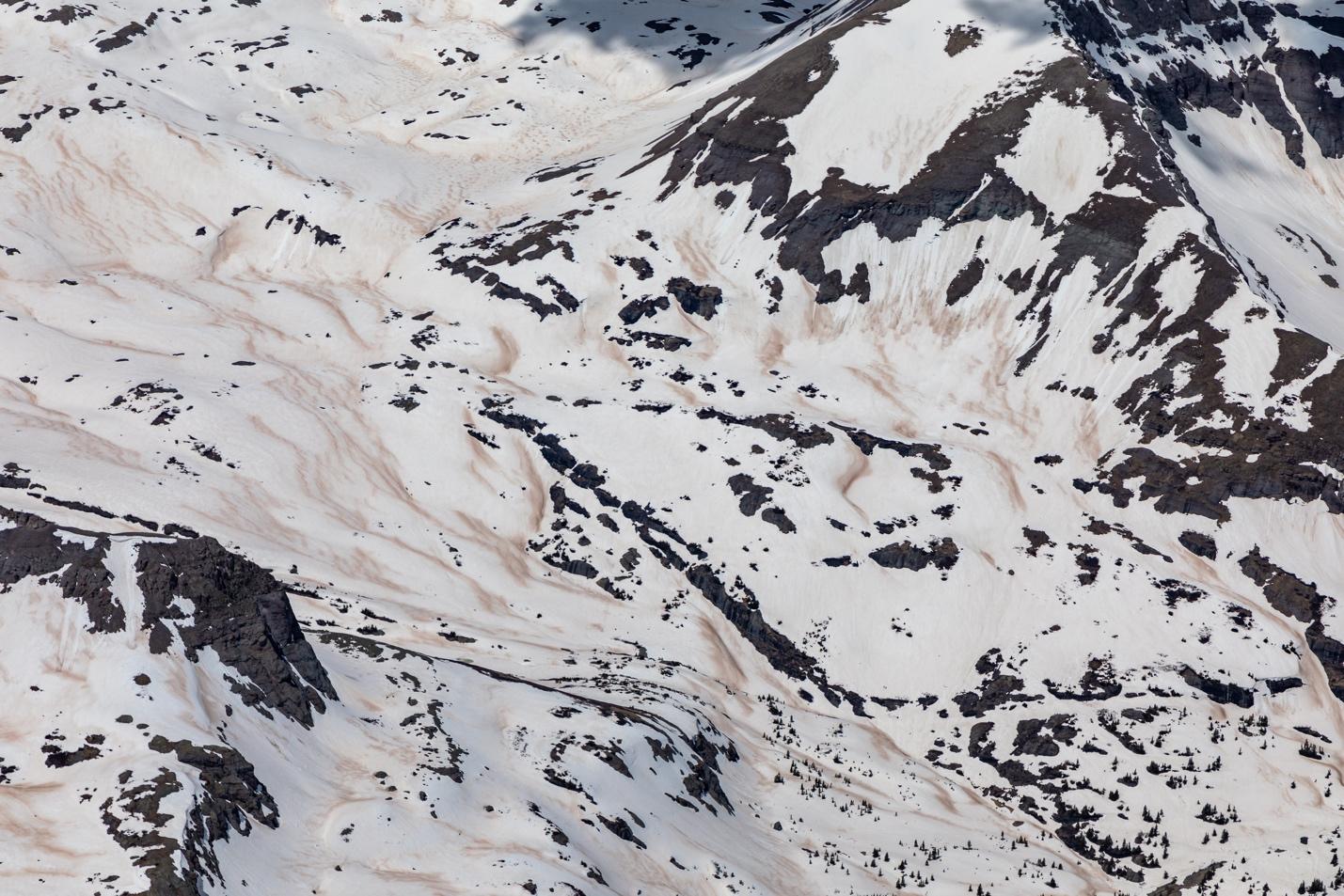
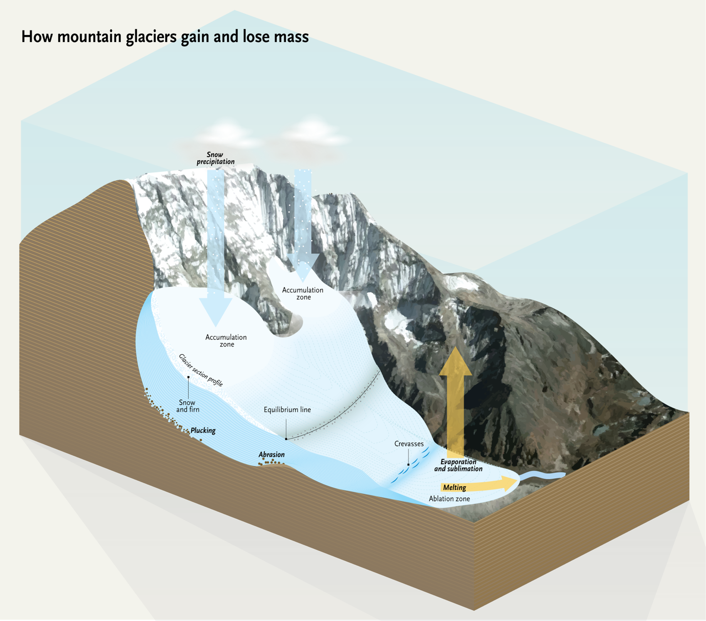
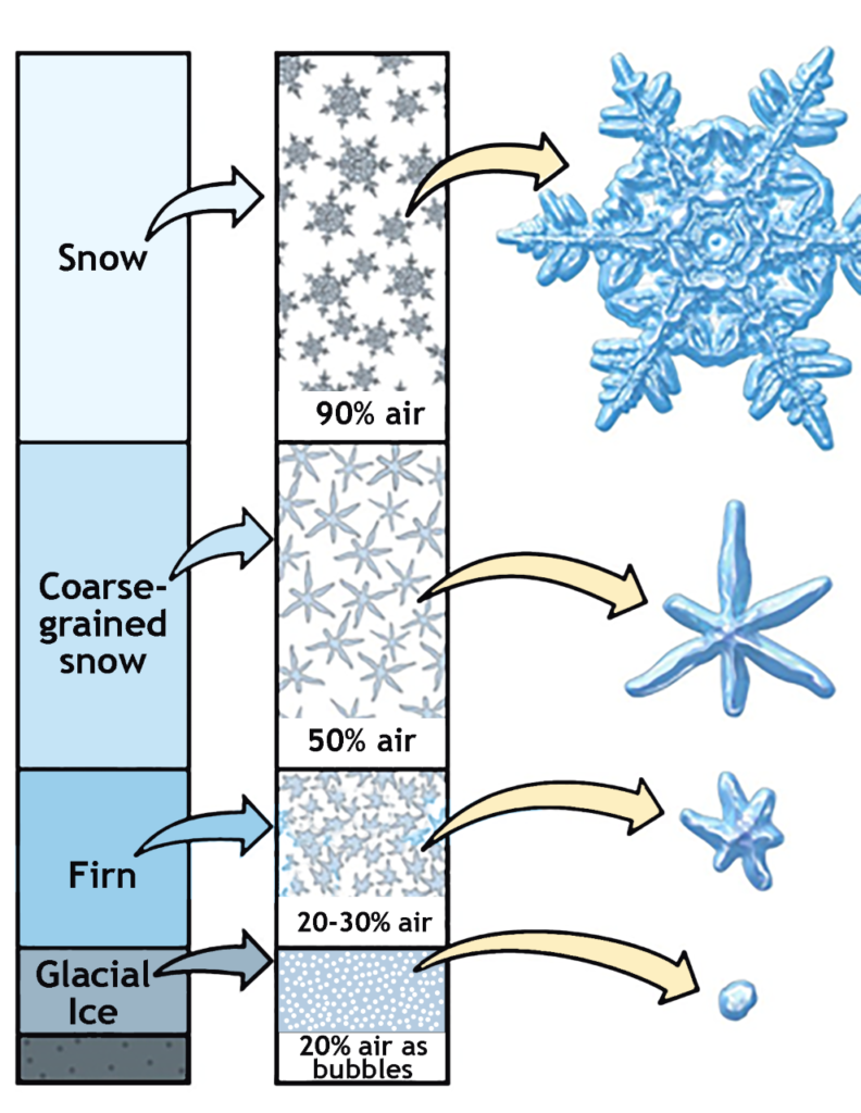
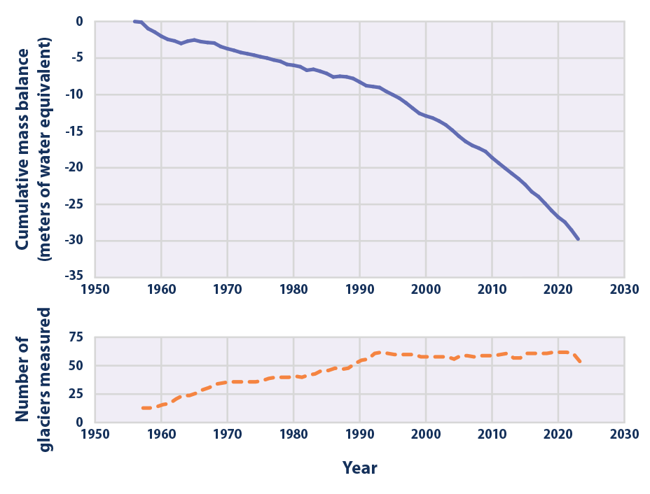
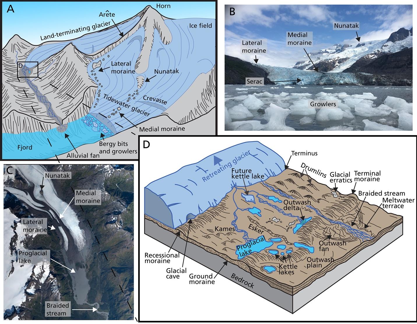
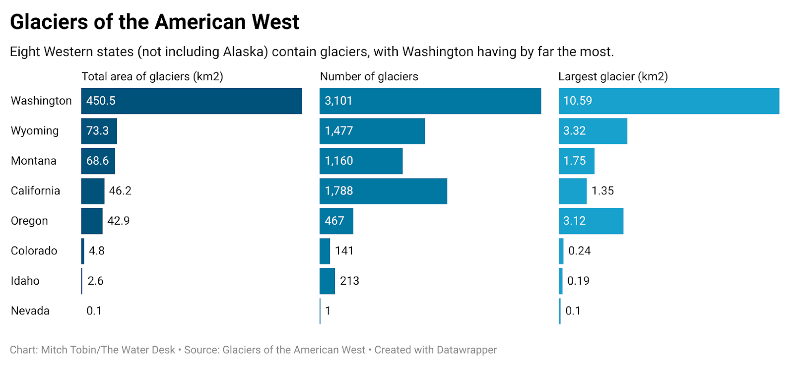
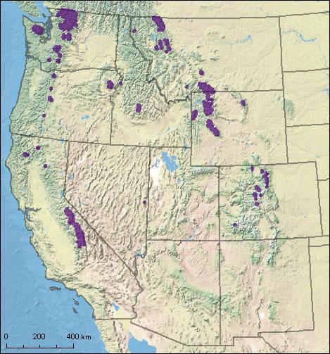
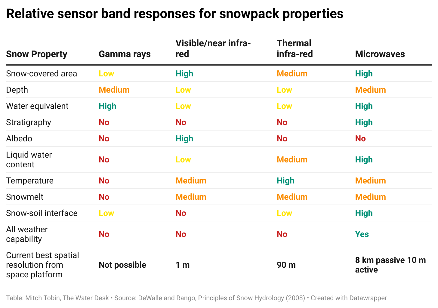
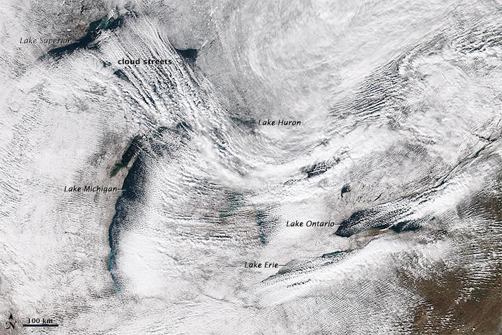
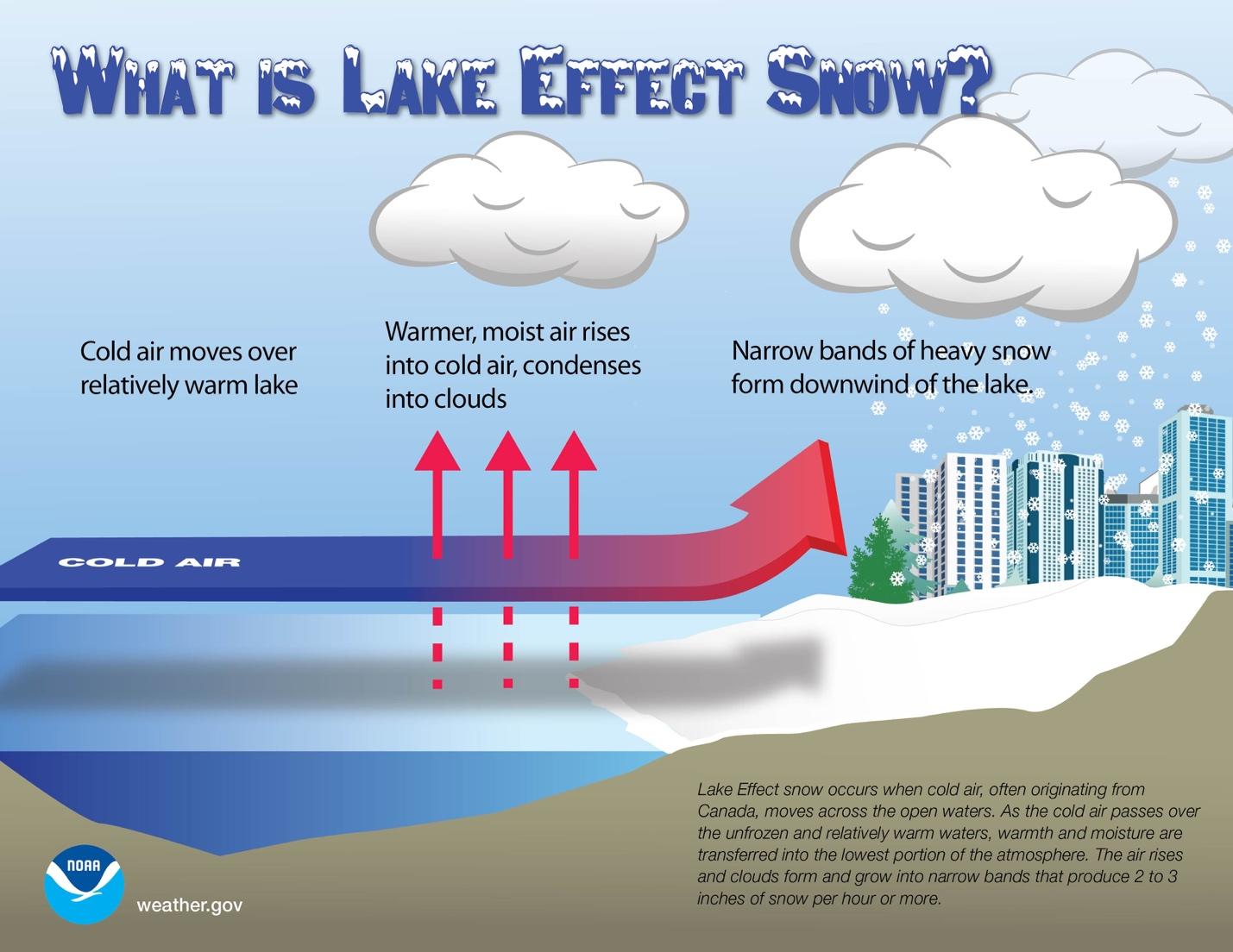
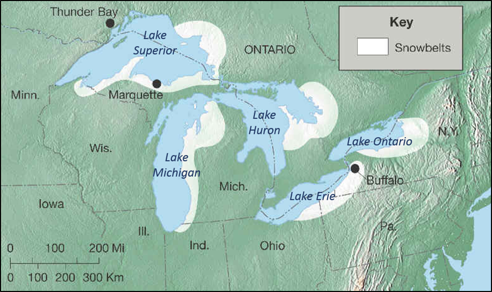
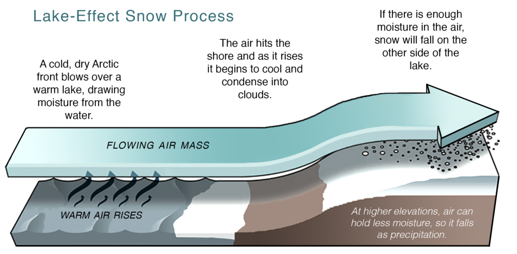
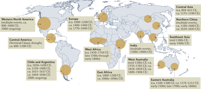
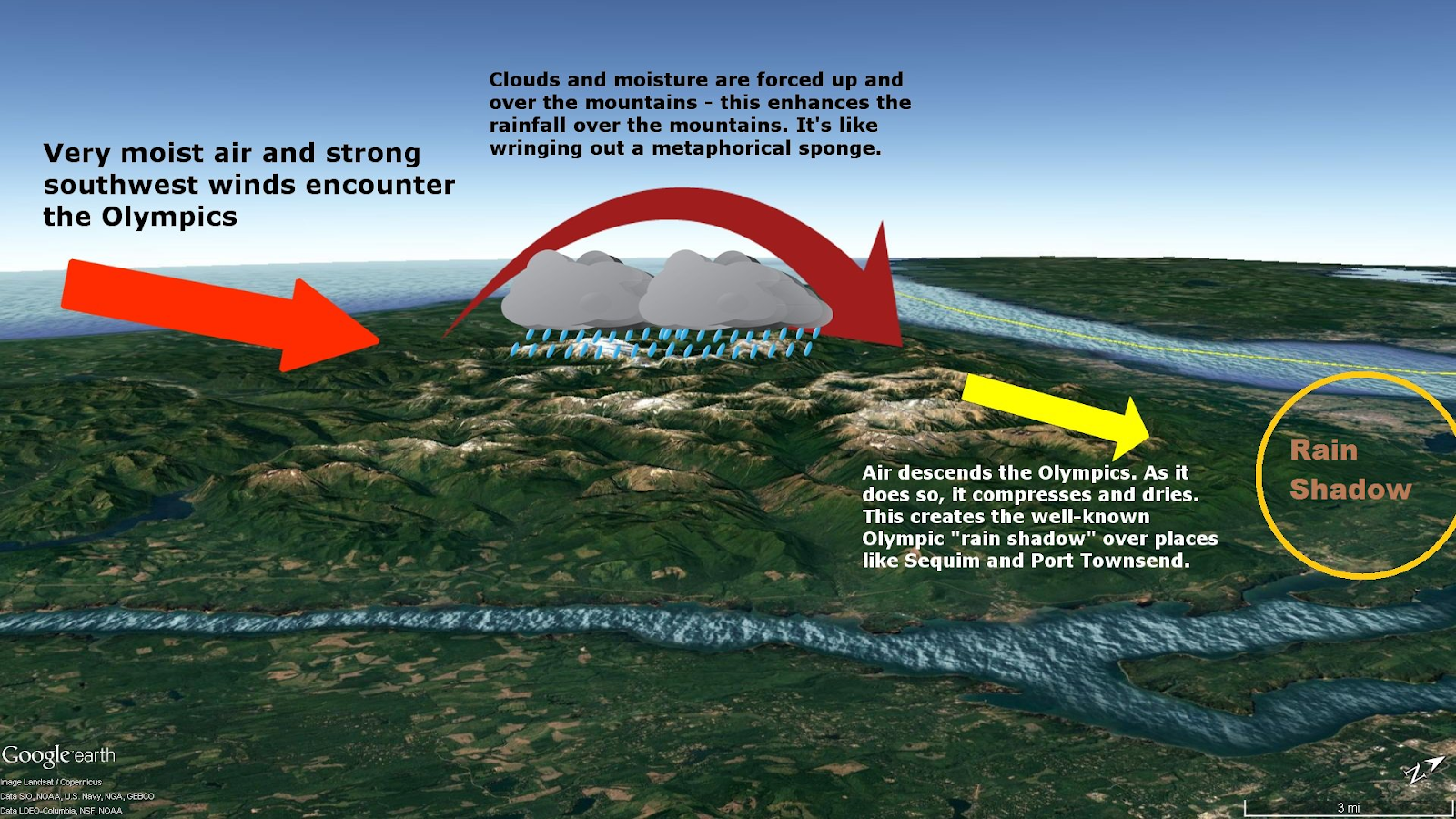
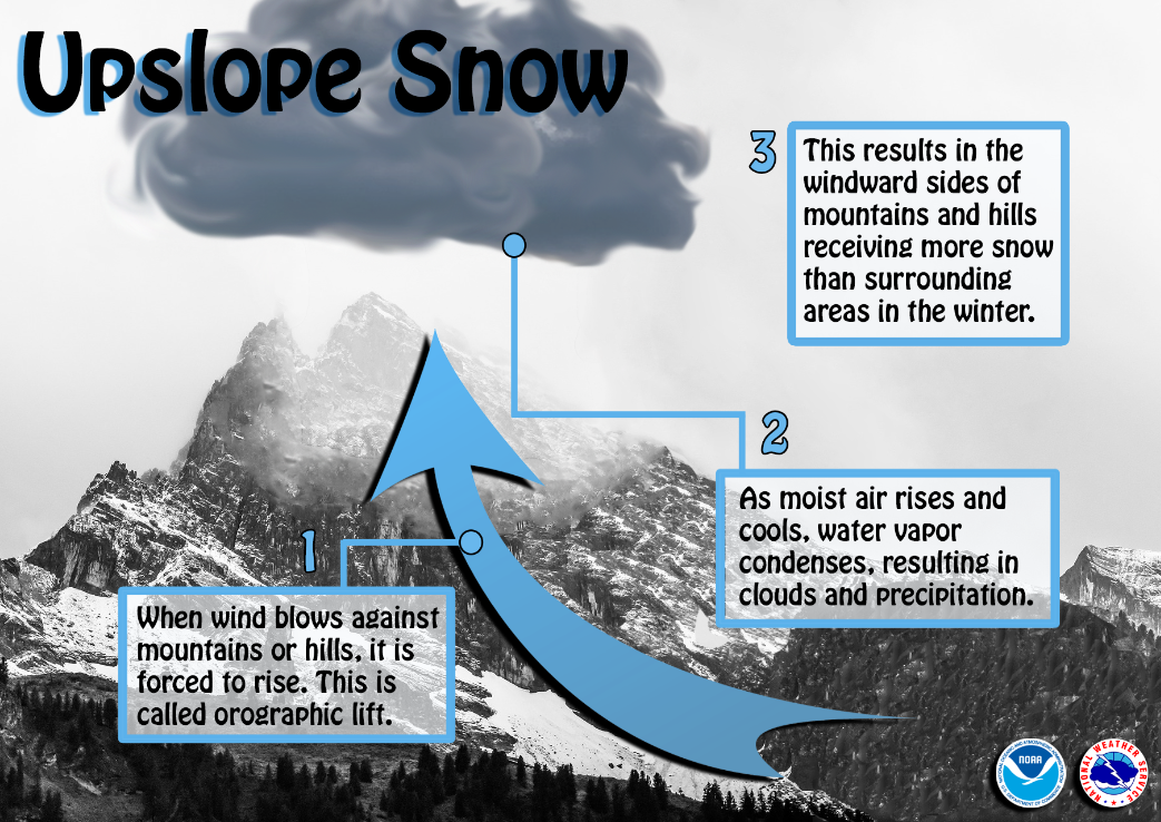
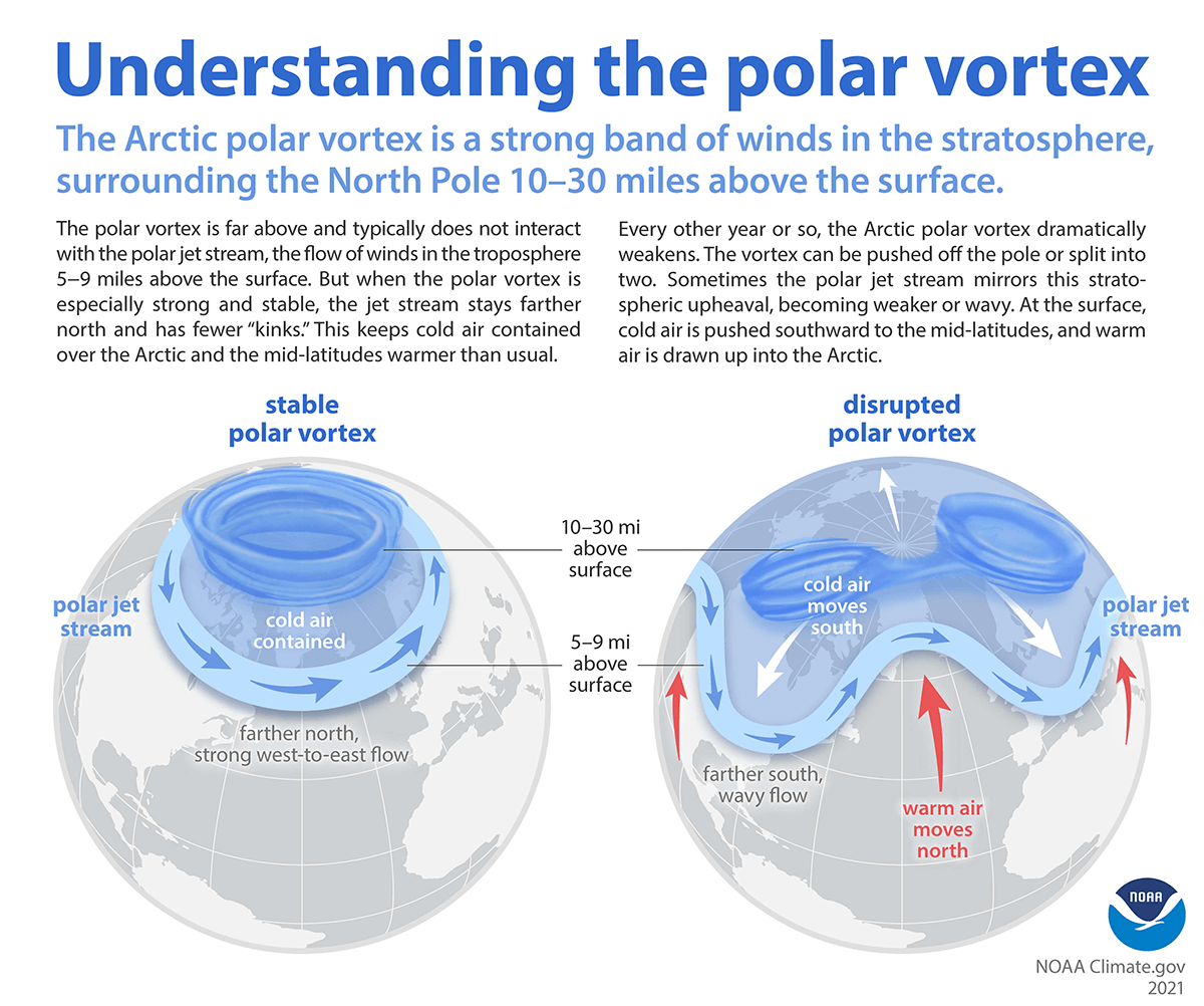
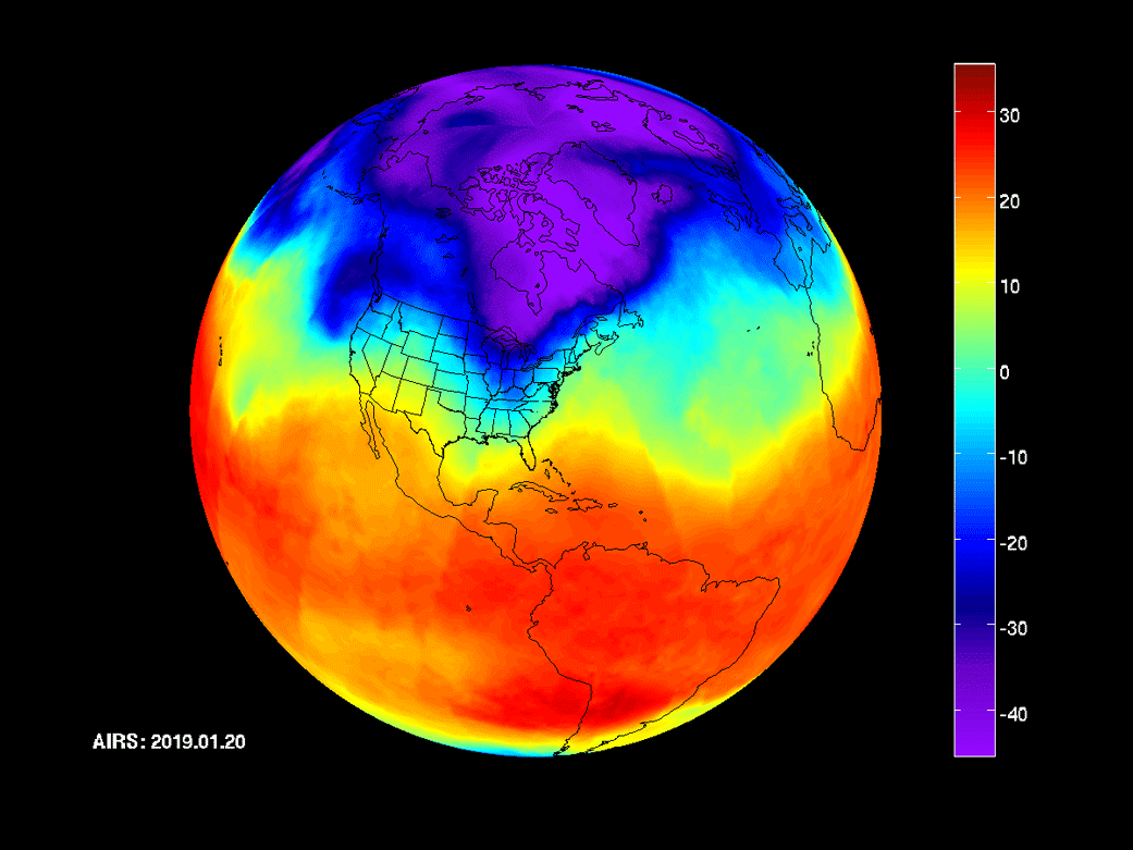
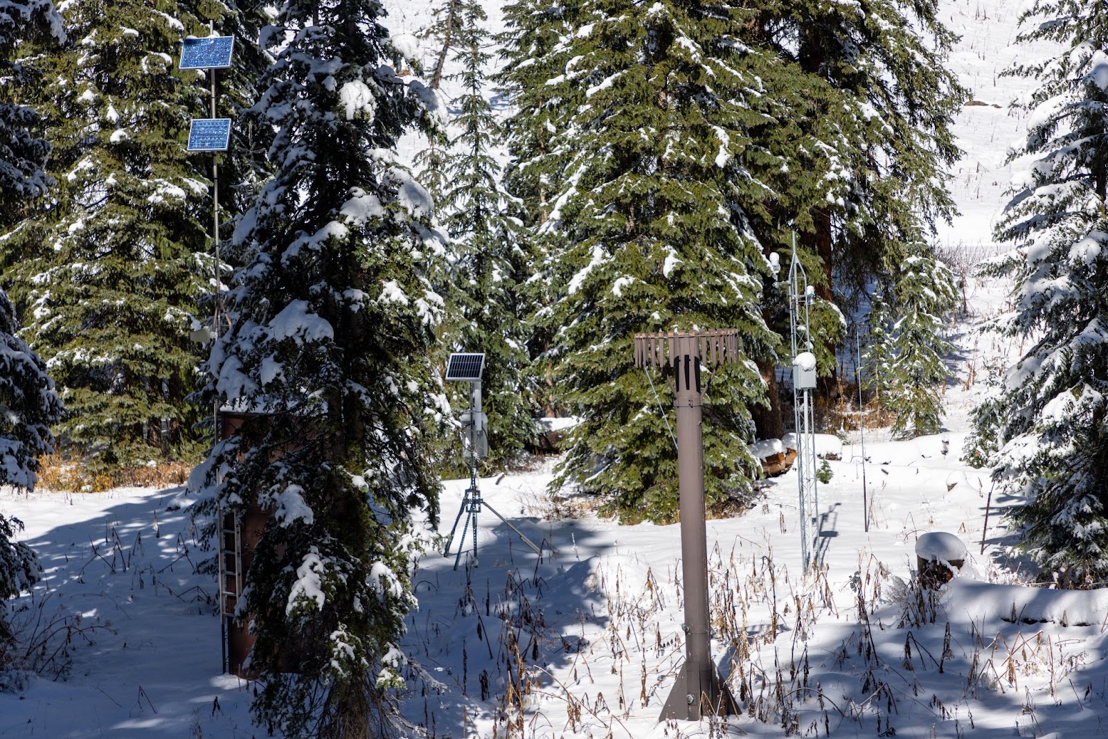
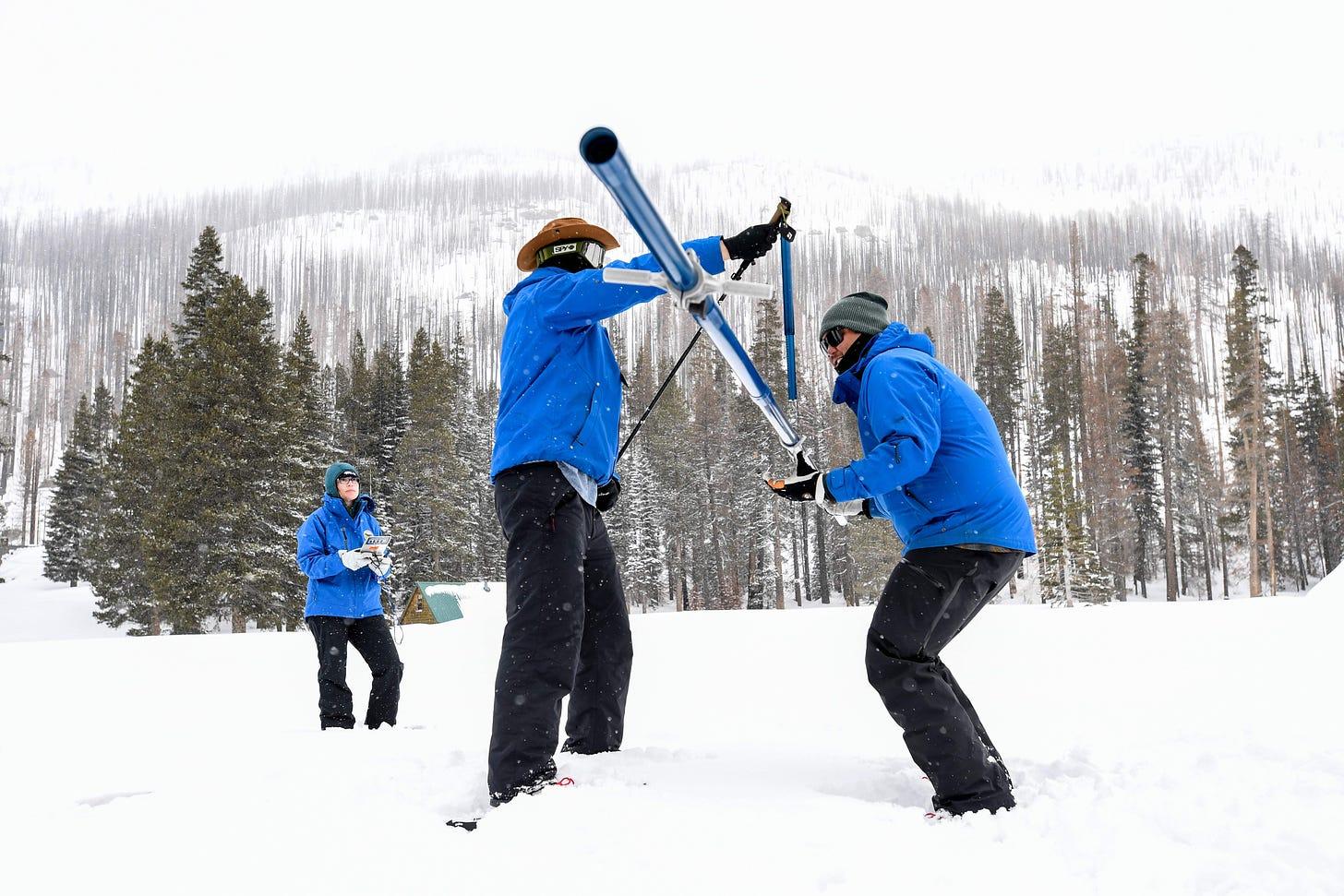
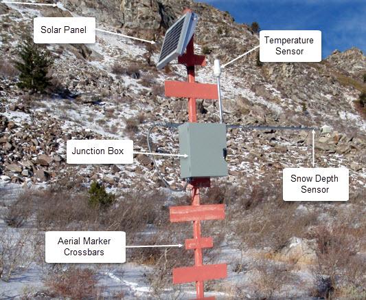


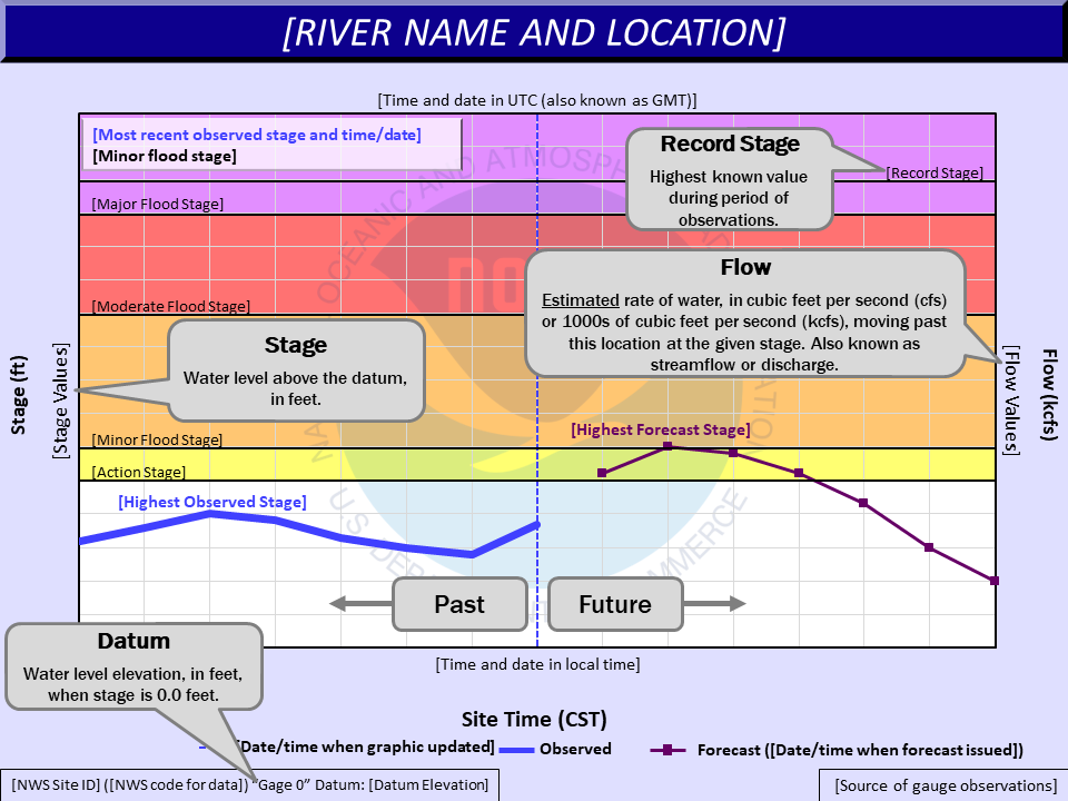


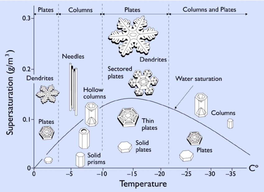