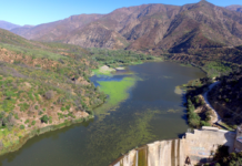
Videos and photos: Green Mountain Reservoir and Colorado/Blue confluence drone flight, October 2019
View this gallery for high-resolution downloads »
This page features drone-captured imagery of Green Mountain Reservoir and the confluence of the Colorado River and Blue River, near...
Efforts to relocate an ancient wetland could help determine the fate of a water...
The cities of Aurora and Colorado Springs are looking to develop additional water in Eagle County and divert it to Colorado's Front Range.
Study: Colorado River water crisis could dry out Front Range, West Slope cities and...
If drought and climate change continue to sap the Colorado River, and a legal crisis erupts with downstream states, six of Colorado's eight major river basins could be forced to give up water.
The dam nobody wants just won’t go away
Dams can stop the natural flow of sand and silt to the sea—resulting in coastal wetland loss and disappearing beaches—as well as preventing fish from reaching vital spawning grounds.
Monitoring will make sure Aspen snowmaking doesn’t harm creeks
A monitoring program is trying to ensure that Aspen Skiing Co.’s increased water use for snowmaking won’t harm area creeks.
It was a squeaker, but Colorado voters say yes to sports betting, cash for...
Colorado voters narrowly approved Proposition DD and created a new sports-betting tax whose proceeds will help fund water projects across the state.
Proposition DD barely squeaks by
Colorado voters have narrowly passed a measure that will legalize sports betting and use the taxes raised to fund projects outlined in the Colorado Water Plan.
Photos: Colorado River headwaters flight, October 2019
This photo gallery features images shot during a Lighthawk flight to the Colorado River headwaters and surrounding areas.
The flight began at Rocky Mountain Metropolitan Airport in Broomfield, proceeded...
As wildfires grow more intense, California water managers are learning to rewrite their emergency...
Agencies share lessons learned as they recover from fires that destroyed facilities, contaminated supplies and devastated their customers
Demand-management groups multiply in Colorado water fight
Several groups are studying demand management, underscoring persistent tensions between the Western Slope and Front Range water managers.


