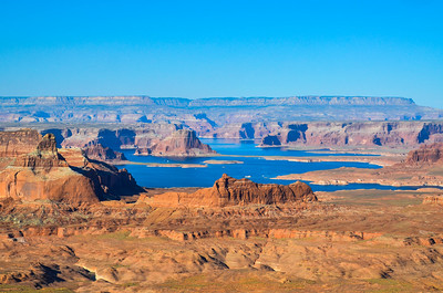
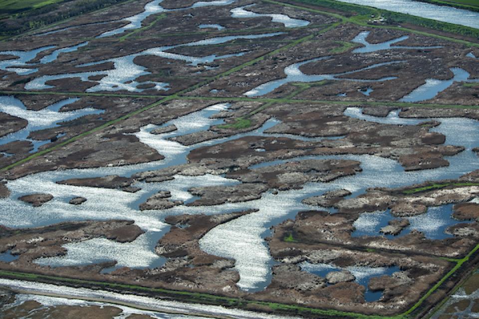
Lake Powell would become home to a special 500,000 acre foot drought pool if Colorado, Wyoming, Utah and New Mexico agree to save enough water to fill it. Credit: Creative Commons
If Colorado decides to join in an historic Colorado River drought protection effort, one that would require setting aside as much as 500,000 acre-feet of water in Lake Powell, can it find a fair way to get the work done? A way that won’t cripple farm economies and one which ensures Front Range cities bear their share of the burden?
That was one of the key questions more than 100 people, citizen volunteers and water managers, addressed last week as part of a two-day meeting in Denver to continue exploring whether the state should participate in the effort. The Lake Powell drought pool, authorized by Congress last year as part of the Colorado River Drought Contingency Plan, would help protect Coloradans if the Colorado River, at some point in the future, hits a crisis point, triggering mandatory cutbacks.
But finding ways to set aside that much water, the equivalent of what roughly 1 million people use in a year at home, is a complex proposition. The voluntary program, if created, would pay water users who agree to participate. And it would mean farmers fallowing fields in order to send their water downstream and cities convincing their customers to do with less water in order to do the same. The concept has been dubbed “demand management.”
Among the key issues discussed at the joint Interbasin Compact Committee and demand management work group confab last week is whether there is a truly equitable way to fill the drought pool that doesn’t disproportionately impact one region or sector in the state.
In addition, a majority of participants reported that they wanted any drought plan to include environmental analyses to ensure whichever methods are selected don’t harm streams and river habitat.
Some pointed to the need to identify “tipping points” when reduced water use would create harmful economic effects in any given community, and suggested that demand management be viewed as a shared responsibility.
Flipping the narrative of shared responsibility, participants said sharing benefits equally was important as well. They want to ensure that people selected to participate would do so on a time-limited basis, so that a wide variety of entities have the opportunity to benefit from the payments coming from what is likely to be a multi-million-dollar program.
“People are starting to get it,” said Russell George. George is a former lawmaker who helped create the 15-year-old public collaborative program which facilitates and helps negotiate issues that arise among Colorado’s eight major river basins and metro area via basin roundtables. He chairs the Interbasin Compact Committee, composed of delegates from those roundtables.
“It’s understood that we have to be fair about this and we have to share [the burden] or it won’t work. I think we’re making great progress,” George said.
The Colorado River is a major source of the state’s water, with all Western Slope and roughly half of Front Range water supplies derived from its flows.
But growing populations, chronic drought and climate change pose sharp risks to the river’s ability to sustain all who depend on it. The concept behind the drought pool is to help reduce the threat of future mandatory cutbacks to Colorado water users under the terms of the 1922 Colorado River Compact.
The public demand management study process, facilitated by the Colorado Water Conservation Board, has caused concern among different user groups, including farmers. Because growers consume so much of the state’s water, they worry that they are the biggest target for water use reductions, which could directly harm their livelihoods if the program isn’t implemented carefully and on a temporary basis.
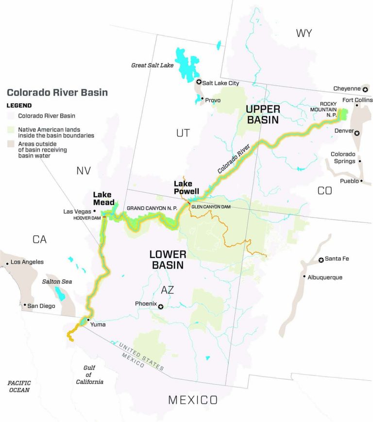
In early 2019 the seven states that comprise the Colorado River Basin—Arizona, California and Nevada in the Lower Basin, and Colorado, New Mexico, Utah and Wyoming in the Upper Basin—agreed for the first time to a series of steps, known as the Colorado River Basin Drought Contingency Plan, to help stave off a crisis on the river.
Colorado River Basin. Credit: Chas Chamberlin
And while Lower Basin states have already begun cutting back water use in order to store more in Lake Mead, the four Upper Basin states are still studying how best to participate to shore up Lake Powell. For the drought pool program to move forward, all four states would need to agree and contribute to the pool. George pointed to Colorado as a leader among the four states, saying it would likely be responsible for contributing as much as 250,000 acre-feet to the pool.
“We appreciate the focus, dedication and collaboration of our work group members,” said CWCB Director Rebecca Mitchell in a statement. “This workshop was the next step in sharing ideas for Colorado’s water future, and positioning our state as a national leader for cooperative problem solving.”
The eight major volunteer work groups, addressing such topics as the law, the environment, agriculture and water administration, will continue meeting throughout the year, with a mid-point report based on their findings to date due out sometime this summer.
Travis Smith, a former CWCB board member from Del Norte who is now participating on the agriculture work group, said he is hopeful that the work groups will be able to come up with a plan the public will endorse. Any final plan will likely have to be approved by Colorado lawmakers.
“Coming together to address Colorado’s water future is something we’ve been practicing through the [nine river basin roundtables] for years. Will we get there? Absolutely,” Smith said.
Jerd Smith is editor of Fresh Water News. She can be reached at 720-398-6474, via email at jerd@wateredco.org or @jerd_smith.
Fresh Water News is an independent, non-partisan news initiative of Water Education Colorado. WEco is funded by multiple donors. Our editorial policy and donor list can be viewed at wateredco.org
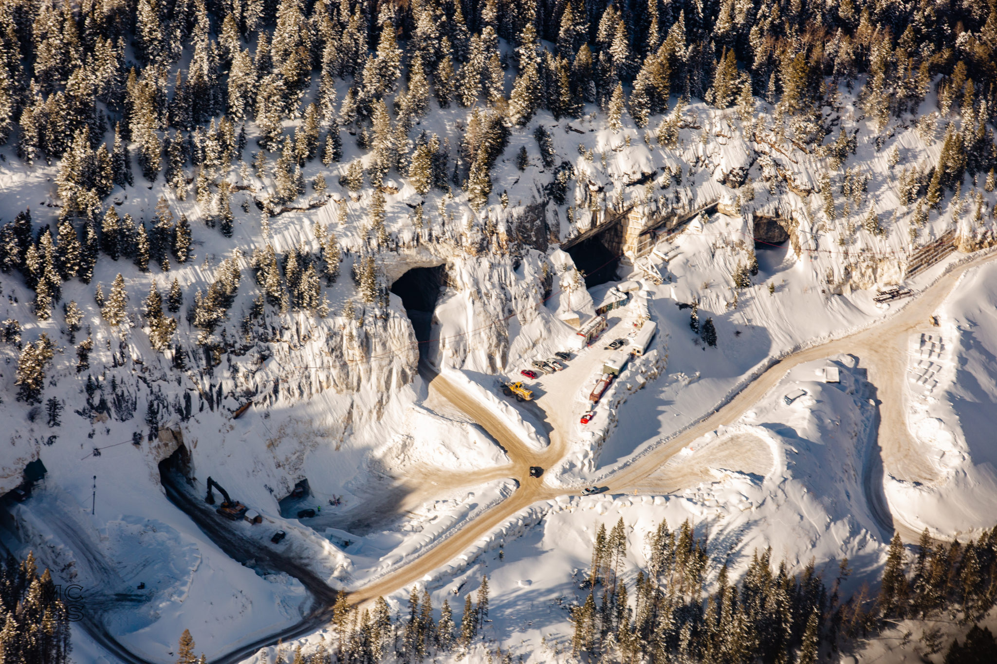
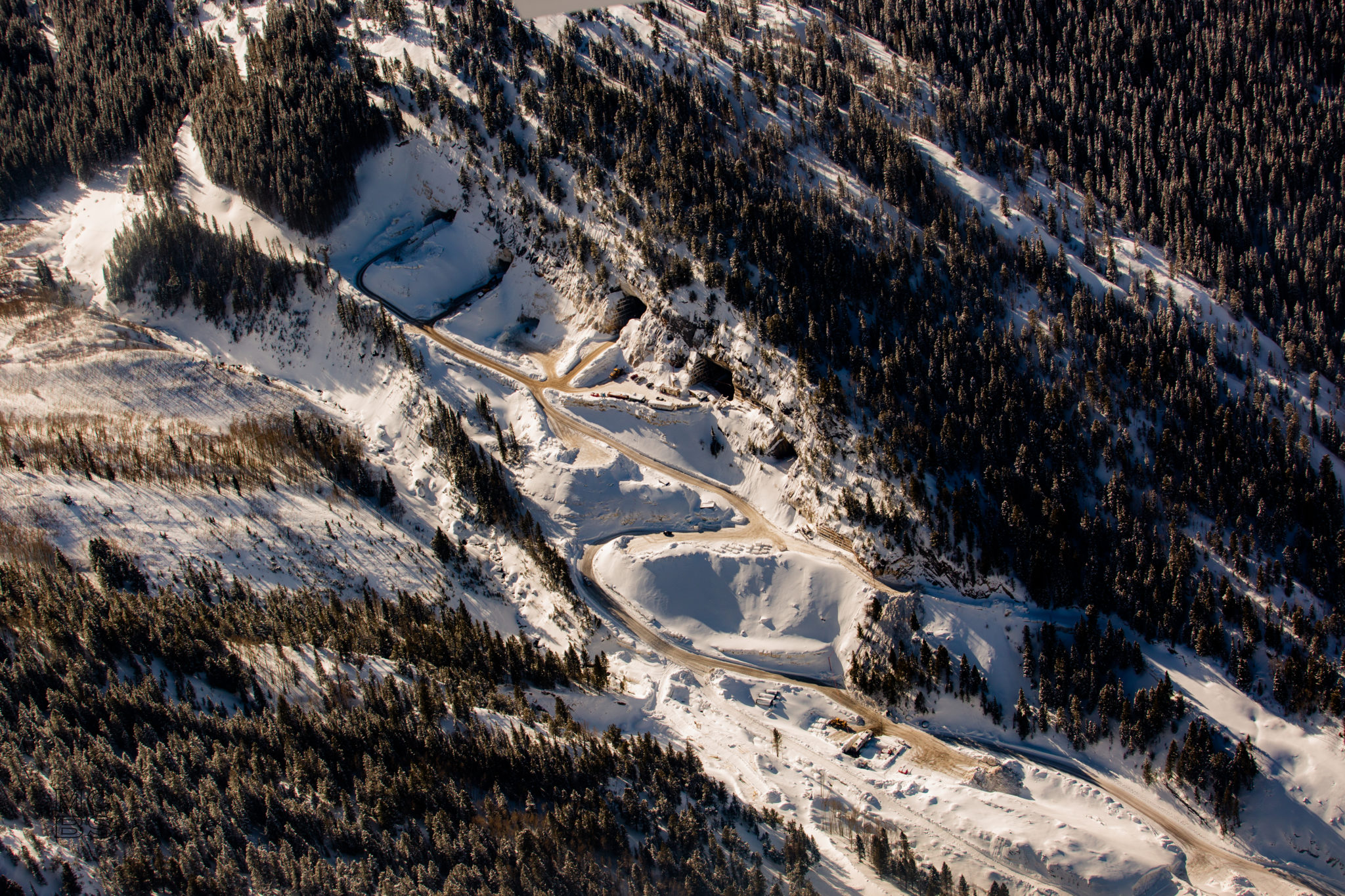
The Pride of America Mine, long known as the Yule Quarry, as seen from the air in January. The marble quarry’s operators, Colorado Stone Quarries, are facing scrutiny related to a diesel spill and the temporary diversion of Yule Creek. Photo by Mike Stevens/Ecoflight
By Heather Sackett
MARBLE — The U.S. Army Corps of Engineers has determined that the operators of a local marble quarry violated the Clean Water Act when they diverted a tributary of the Crystal River to make way for a mining road.
In the fall of 2018, Colorado Stone Quarries, which operates the famed Yule Quarry just outside the town of Marble, diverted Yule Creek from its natural channel — located on the west side of Franklin Ridge, a rock outcropping — to the east side of the ridge. Operators piled the original streambed with fill material, including marble blocks.
Although this move probably spared Yule Creek the impacts of a diesel spill last October, it was done without the proper permits or oversight, according to the Army Corps.
Under Section 404 of the Clean Water Act, a project requires a permit from the Army Corps if it includes the discharge of dredged or fill materials into waters such as rivers, streams and wetlands. CSQ did not obtain a permit for the project because company officials thought the work was exempt, citing the temporary nature of the access road and creek diversion.
Army Corps officials disagreed.
“The work performed does not qualify for an exemption,” states a March 5 letter from Army Corps Colorado West Section chief Susan Nall, as the work “is being utilized for purposes other than moving mining equipment (e.g., hauling mined marble, accessing other portions of the mine, fuel staging area, and performing spill cleanup and monitoring activities) as required by the applicable exemption.”
Nall’s letter then declares: “Therefore, the work is a violation of the Clean Water Act.”
In order to remedy the situation, the Army Corps wants Yule Creek returned to its original alignment.
“Our preference is always to preserve the physical waterway if possible,” Nall said.
CSQ is considering a few different alignments for Yule Creek.
“The current alignment does accomplish the goal of creating separation between the creek and mining activities, which benefits the watershed,” CSQ general manager Daniele Treves said in a prepared statement.
The company plans to apply for an “individual permit,” which will require a 30-day public notice, public review and comments. The final decision on the Yule Creek alignment rests with the Army Corps.
The diversion of Yule Creek came to the attention of Army Corps staff after October’s diesel spill, which released roughly 5,500 gallons of fuel from storage tanks onto the ground.
Although CSQ notified the Army Corps in 2018 that they were planning to divert about 1,500 feet of the creek, the company didn’t follow the proper procedure and the Army Corps didn’t realize the scope of the work it was planning, according to Nall.
“We did not realize it was a formal request for concurrence of an exemption. That might have been an error on our part,” Nall said. “We didn’t object, and they took it as a concurrence. Nothing is exempt until we say it is. They really should have obtained it from us in writing.”
Marble blocks line the banks of the Crystal River where County Road 3C, known as the Quarry Road, crosses the river. Marble quarry operators Colorado Stone Quarries was fined $18,600 by the Division of Reclamation, Mining and Safety for an October diesel spill. Photo by Heather Sackett/Aspen Journalism
DRMS penalty
On Wednesday, the board of the Colorado Division of Reclamation, Mining and Safety levied a $18,600 penalty for the October spill. The accident resulted in the quarry’s violation of three state statutes: unauthorized release of pollutants into groundwater, failure to minimize disturbance to water quality and failure to comply with the conditions of the permit.
DRMS determined September’s relocation of generators and the diesel-fuel tanks that supplied them was not approved and was a violation of CSQ’s permit. The diesel tanks were not put in secondary containment structures.
CSQ has agreed to pay the fine.
“We are always more interested in gaining compliance than the monetary aspect of it,” said Russell Means, minerals program director for DRMS.
According to an agreement between quarry operators and state regulators, CSQ also will continue to clean up the site, including bioremediation treatments to remove hydrocarbons from the soil and long-term water-quality monitoring.
Means and Nall said CSQ has been cooperative throughout the process.
“I think everybody’s interest is the same — we would all like to see the spill area cleaned up and the best thing for Yule Creek,” Nall said.
The quarry, now known as The Pride of America Mine, is owned by Italian company Red Graniti and employs about 30 to 40 people. According to CSQ, there are enough marble reserves contained in its six galleries to continue mining at the current rate for more than 100 years.
Vehicles and machinery were parked outside the entrances to the marble galleries of the Pride of America Mine in January. The quarry operators Colorado Stone Quarries are facing scrutiny from federal and state agencies after an October diesel spill. Photo by Mike Stevens/EcoFlight
By Heather Sackett
MARBLE — Colorado Stone Quarries, the operator of Marble’s famed Yule quarry, is facing scrutiny and possible penalties from federal and state regulators after an October diesel spill that shut down operations for nearly two months.
The U.S. Army Corps of Engineers is looking into whether a special permit is needed for the diversion of Yule Creek, which was done to make way for a temporary mining road. In addition, the Colorado Division of Reclamation, Mining and Safety says it believes the quarry violated state statutes by releasing pollutants into groundwater.
Representatives from state DRMS and the Army Corps visited the site, which is located 3 miles up County Road 3C from the town of Marble, on Feb. 11, four months after 5,500 gallons of diesel fuel leaked from a tank on the property.
Nearby Yule Creek, which flows into the Crystal River, was spared from the Oct. 11 spill because the waterway had been diverted from its natural channel to the east of Franklin Ridge so operators could construct a temporary access road to the quarry.
Because the access road and creek diversion was supposed to be temporary, officials at Colorado Stone Quarries, or CSQ, claimed the project did not need a permit from the Army Corps. Under Section 404 of the Clean Water Act, a project requires a permit from the Army Corps if it includes the discharge of dredged or fill materials into waters, such as rivers, streams and wetlands.
To qualify for a 404 exemption for the construction of temporary roads for moving mine equipment, CSQ is required to meet 15 best-management practices. CSQ says its activities comply with those practices.
The temporary diversion was approved by DRMS in September 2018 in what’s known as a technical revision to the quarry’s permit.
But because of ongoing cleanup and water-quality monitoring as a result of the spill, the temporary road and creek diversion will be in place longer than intended — until at least the fall of 2022, according to a report from the company. Until then, the old Yule Creek channel also will remain full of fill material, including marble blocks. That means the project might need a permit from the Army Corps after all.
“Given that the subject haul road will be in place for the foreseeable future (i.e., not temporary), the exemption under which the road was constructed may not be applicable,” reads a letter from the Army Corps requesting more information from CSQ.
Army Corps officials were alerted to the quarry’s plans for a temporary road and creek diversion when the quarry applied for the technical revision in 2018, but the agency did not raise concerns about the quarry needing a 404 permit at that time.
CSQ and its consultant Greg Lewicki and Associates are offering the Army Corps three potential options for remedying the situation: Take no action, meaning the quarry would follow the plan for a temporary road and creek diversion laid out in its technical revision and the quarry would not get a permit from the Army Corps; leave the creek in its current alignment to the east side of Franklin Ridge, which would require an Army Corps permit; or return Yule Creek to its alignment on the west side of the ridge but at a higher elevation than the pre-diversion alignment.
The Army Corps has asked CSQ to provide more information on these three scenarios. The affected stream reach is about 1,500 feet long.
The Pride of America Mine, long known as the Yule Quarry, as seen from the air in January. The marble quarry’s operators, Colorado Stone Quarries, are facing scrutiny related to a diesel spill and the temporary diversion of Yule Creek. Photo by Mike Stevens/EcoFlight
State enforcement
CSQ also may face fines and other punishment from DRMS, which regulates mining in Colorado. According to a Feb. 7 letter from DRMS director Virginia Brannon, the agency believes the quarry is in violation of three state statutes: unauthorized release of pollutants into groundwater, failure to minimize disturbance to the prevailing hydrologic balance with regard to water quality, and failure to comply with the conditions of the permit.
The diesel spill occurred during the relocation process for the generator and associated fuel tanks. The new location was not approved by DRMS.
“Therefore, the Division has reason to believe that a violation exists to the Colorado Land Reclamation Act for the Extraction of Construction Materials … and (has) scheduled this matter to appear before the Mined Land Reclamation Board,” the letter reads.
CSQ is scheduled to appear before the board March 25 in Denver. The board could issue a cease-and-desist order or impose a fine between $100 and $1,000 for each day of violation.
The spill at the quarry, which is now known as The Pride of America Mine, was marked by delays in reporting and cleanup.
Red Graniti, a company in Cararra, Italy, owns the quarry, which employs about 30 to 40 people and out of whose pure-white stone has been carved the Lincoln Memorial, the Colorado Capitol building and the Tomb of the Unknown Soldier.
In 2016, the quarry was granted a permit for a 114-acre expansion, for a total of 124 permitted acres. According to CSQ, there are enough marble reserves contained in its six galleries to continue mining at the current rate for more than 100 years.
Aspen Journalism collaborates with The Aspen Times and other Swift Communications newspapers on coverage of rivers and water. This story ran in the Feb. 22 edition of Aspen Journalism and The Aspen Times.
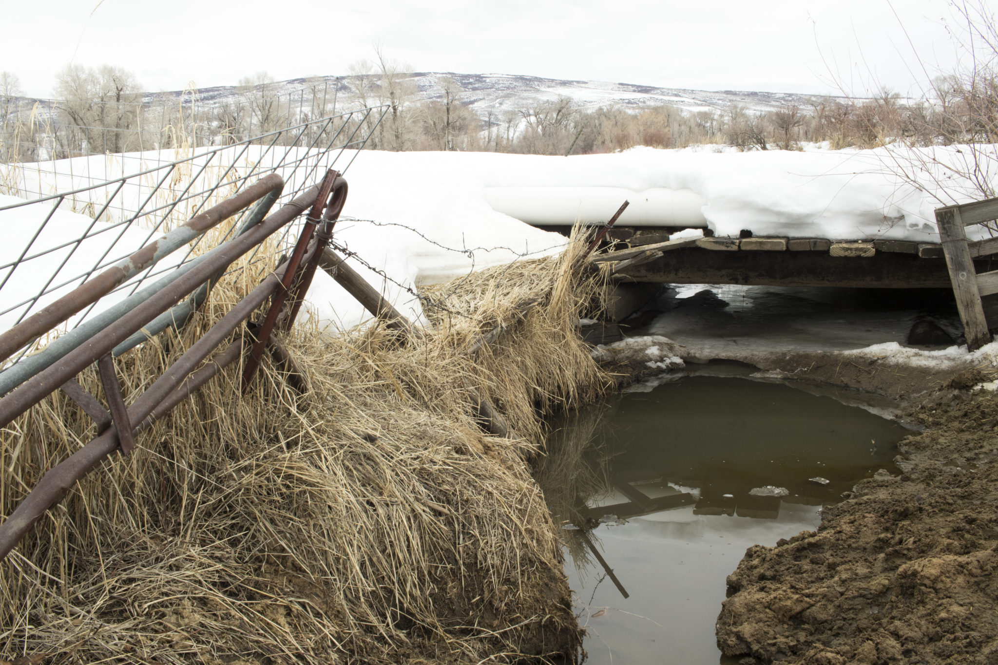
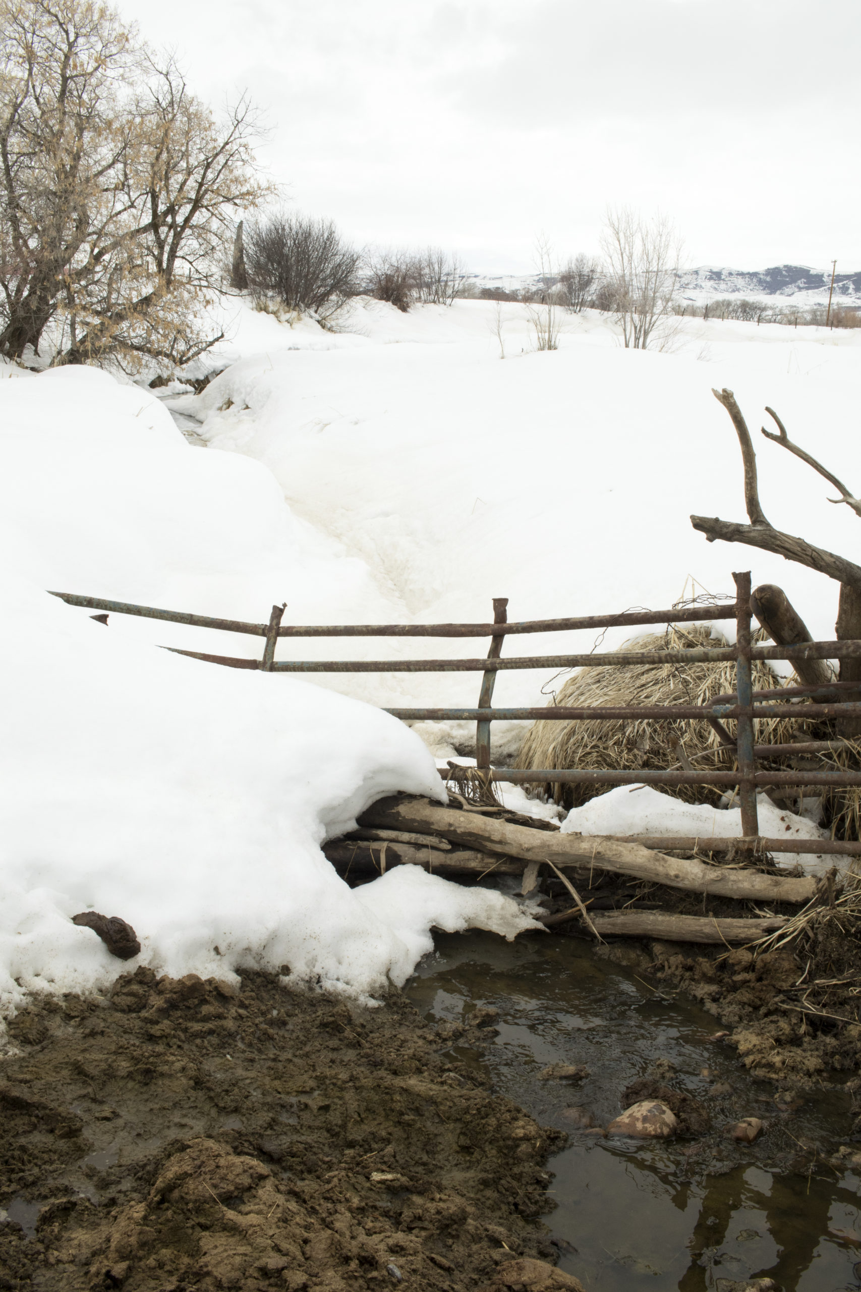
A small pool of water along the Walker Ditch is kept free of ice and snow all winter long in order to provide water for cattle on the Monger Ranch near Hayden. A bill recently passed the Colorado legislature that allows ranchers’ historical stock watering rights to stay first in line, ahead of instream flow rights for the environment. Lauren Blair/Aspen Journalism
By Lauren Blair
CRAIG — A bill that cleared the Colorado legislature with bipartisan support March 4 seeks to resolve an eight-year debate over how ranchers and other water users can maintain their historical water use when dry conditions trigger cutbacks to protect streamflows.
House Bill 1159, which passed the House with a unanimous 63-0 vote and the Senate with a 31-1 vote, authorizes state water officials to confirm historical usages, such as water used for livestock, whether or not it’s held in an official water right. This allows ranchers’ uses to stay first in line for water ahead of the stream protections, known as instream-flow rights.
“It’s really a belt-and-suspenders clarification of existing authority,” said Zane Kessler, director of government relations for the Colorado River Water Conservation District, which drafted the language for the bill. “I think it’s a good example of when we sit down and pore over these issues, it’s not hard to come up with a fix that protects West Slope water users and provides the state engineer the authority he needs to continue administering them.”
Instream-flow rights, which are held exclusively by the Colorado Water Conservation Board, exist for the sole purpose of preserving the natural environment of streams and lakes “to a reasonable degree.” Most of these date to the 1970s and are junior to most agricultural-water rights under Colorado’s prior appropriation system of “first in time, first in right.” To date, instream-flow rights protect roughly 9,700 miles of stream in Colorado.
Mud and manure line an access point for cattle to drink from a ditch on Doug Monger’s ranch near Hayden as winter nears its end. A bill recently passed the Colorado legislature that will protect ranchers’ historical uses without requiring them to go to water court. Lauren Blair/Aspen Journalism
Historical uses
The debate over historical uses has turned on whether a water user must go to water court to make their pre-existing use official in a decree.
A 2012 drought brought the question to a head when state officials cut off water users on the Elk River in northwestern Colorado in favor of instream-flow rights. Although many ranchers in the area have water rights for irrigation that are senior to the 1977 instream-flow rights and have historically used that water also for their cattle, the state Division of Water Resources determined that livestock watering wasn’t implicit in irrigation rights.
Those without specific rights for stockwatering were left high and dry once the summer irrigation season was deemed over, even though they had used the water for livestock for generations.
“My grandparents bought this piece of land in 1946,” said Krista Monger, a cattle rancher on the Elk River. “We have the records to show we’ve been using (our water) for livestock.”
Stockwatering and irrigation often go hand in hand. During the irrigation season, if a rancher’s livestock drink from the ditches used to irrigate their fields, the use is considered incidental to irrigation. But once the growing season is over and a rancher keeps the water flowing through the ditch for the exclusive purpose of watering their livestock, the use is not covered under irrigation-water rights.
The amount of water typically used for exclusive stockwatering is a fraction of what is used for irrigating, around 80% to 90% less. Some ranchers also use stock ponds, which require a water-storage right.
More than 90,000 irrigation-water rights are held across the state, of which 29,000 specifically name both irrigation and livestock uses. That means the new law could potentially apply to 61,000 water rights, although not all of these are held by ranchers raising livestock. An additional nearly 32,000 water rights are held exclusively for livestock purposes but not irrigation.
The Monger family holds both irrigation- and livestock-water rights to grow hay and to water their 300 cattle. Her family’s rights and diligent record-keeping meant their ditches kept flowing while their neighbors’ ditches were shut down in 2012, highlighting the need for better record-keeping among the region’s irrigators.
But the incident prompted a statewide debate over the meaning of Colorado statute C.R.S. 37-92-102(3)(b), which states that instream-flow rights are subject to pre-existing uses of water, “whether or not previously confirmed by court order or decree.”
The state Department of Natural Resources, home to both the Division of Water Resources and CWCB, argued that when the instream-flow protections were created, lawmakers intended for water users to make their existing use official in a decree. The Colorado Cattlemen’s Association and the Colorado River Water Conservation District argued that the statute clearly precludes the need for a court decree and sought to protect ranchers’ historical usage without requiring them to go to water court.
“The statute says… prior uses would be honored. But they’re saying the statute doesn’t say what the statute says,” said Mike Hogue, former president of the cattlemen’s group.
After years of negotiations, stakeholders agreed on a simple piece of legislation to clarify the state water engineer’s authority “to confirm a claim of an existing use (if it) has not been previously confirmed by court order or decree,” according to the bill summary. The bill had bipartisan sponsorship from Reps. Marc Catlin, R-Montrose, and Dylan Roberts, D-Avon, and Sens. Don Coram, R-Montrose, and Kerry Donovan, D-Vail.
“I do think this is very helpful legislation,” said State Engineer Kevin Rein, who is with the Division of Water Resources. “We had what I’d call an honest disagreement about what the statute meant. My position is if they change the law and give me a place to hang my hat on, that solves the problem.”
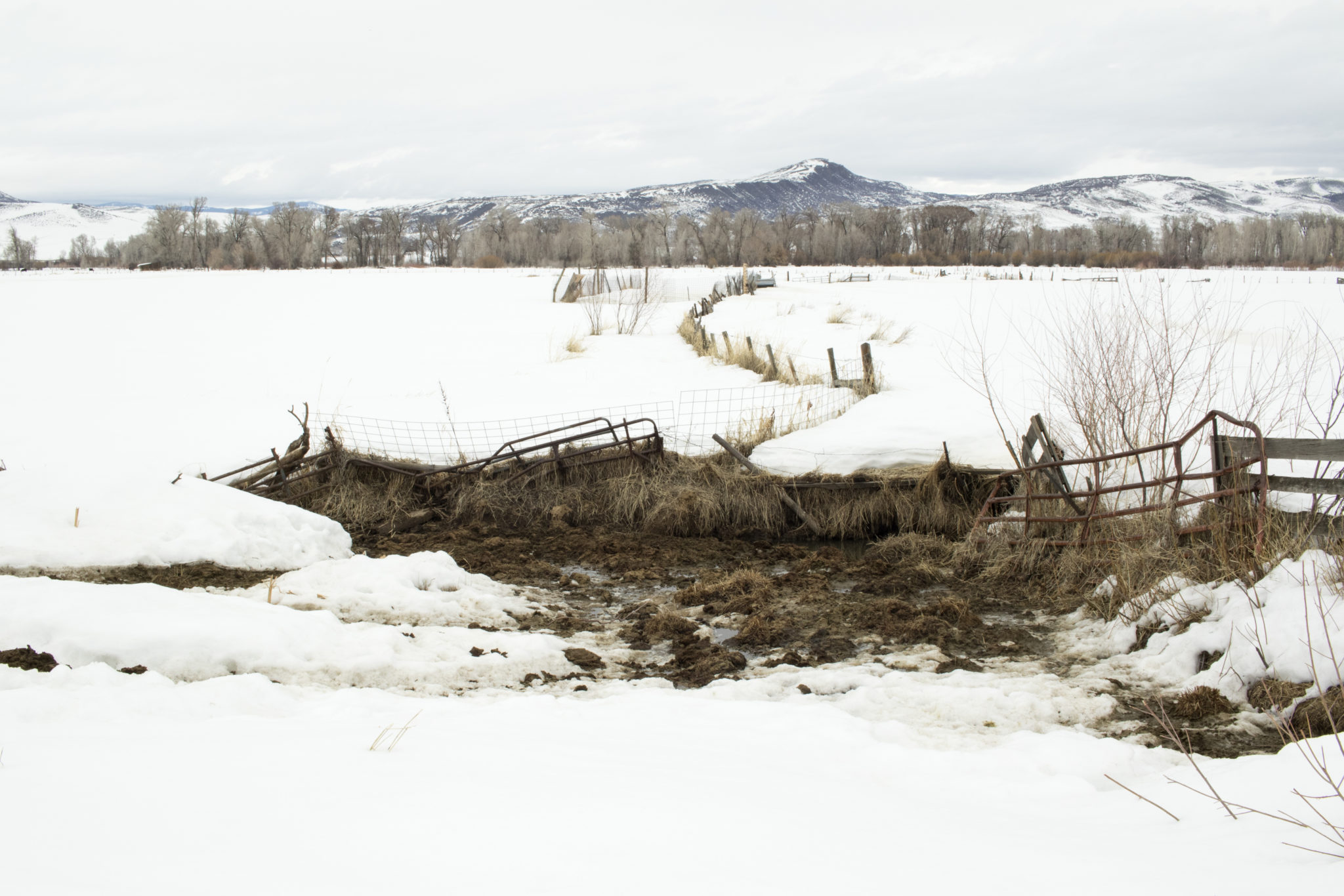
Ditch water trickles back under the cover of snow and ice from a watering hole for cattle on the Monger ranch near Hayden. New legislation prevents ranchers’ water for stock from being shut off by an instream flow right for the environment. Lauren Blair/Aspen Journalism
Wakeup call
However, what the legislation doesn’t resolve — and what is perhaps a bigger Pandora’s box opened by the 2012 incident — is the decision that state water officials made that irrigation rights do not include stockwatering rights. In practice, irrigators around the state, many of whom hold water rights dating to the late 1800s and early 1900s, have used irrigation- or agricultural-water rights not to just irrigate their hayfields, but also to water their livestock.
The new distinction means that ranchers with irrigation rights must apply for livestock water rights if they want to protect their usage into the future. Although the new legislation protects a rancher’s stockwatering use from being shut off specifically by an instream-flow right , their stockwater use could still be cut off if another water user makes a call on the river to fulfill a formal water right.
“We all thought that was part of our ag water rights,” said Doug Monger, a Routt County commissioner and a cattle rancher on the Yampa River in northwest Colorado, and also uncle to Krista Monger. “It’s a wakeup call for all of us.”
Aspen Journalism collaborates with The Craig Daily Press, Steamboat Pilot and Today and other Swift Communications newspapers on coverage of water and rivers. This story ran in the March 16 edition of the Craig Pressand the March 23 edition of Aspen Journalism.
This story was supported by The Water Desk using funding from the Walton Family Foundation.
An ambitious plan would use carbon credits as incentives to convert Delta islands to wetlands or rice to halt subsidence and potentially raise island elevations
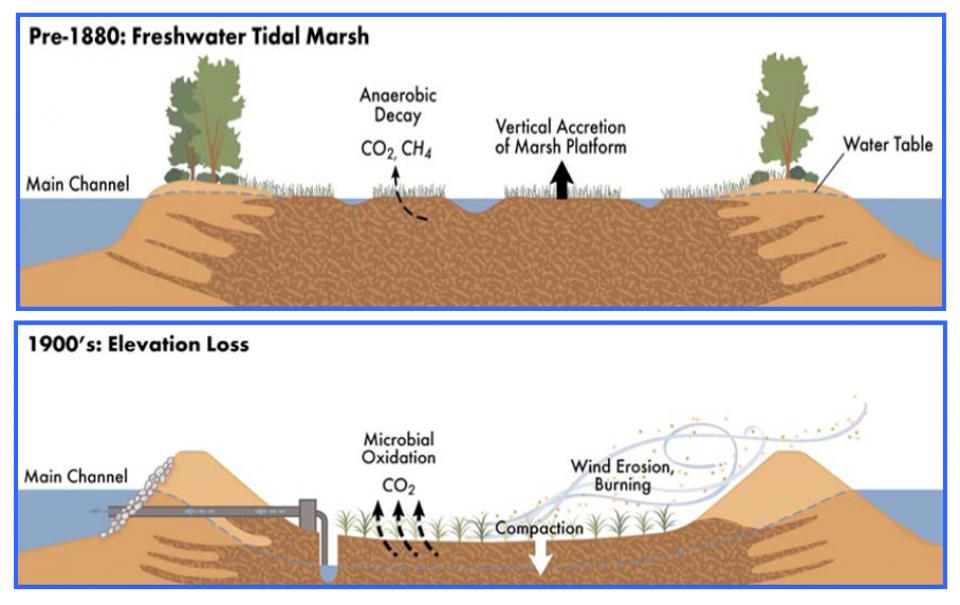
The islands of the western Sacramento-San Joaquin Delta are sinking as the rich peat soil that attracted generations of farmers dries out and decays. As the peat decomposes, it releases tons of carbon dioxide – a greenhouse gas – into the atmosphere. As the islands sink, the levees that protect them are at increasing risk of failure, which could imperil California’s vital water conveyance system.
An ambitious plan now in the works could halt the decay, sequester the carbon and potentially reverse the sinking.
The plan would provide a carrot for farmers in the western Sacramento-San Joaquin Delta to convert their island acreage to rice fields or managed wetlands in order to cut carbon emissions from the decaying peat and protect their lands and communities as well as California’s water hub. The Delta is the “switching yard” for moving water to the massive pumps for the State Water Project and federal Central Valley Project.
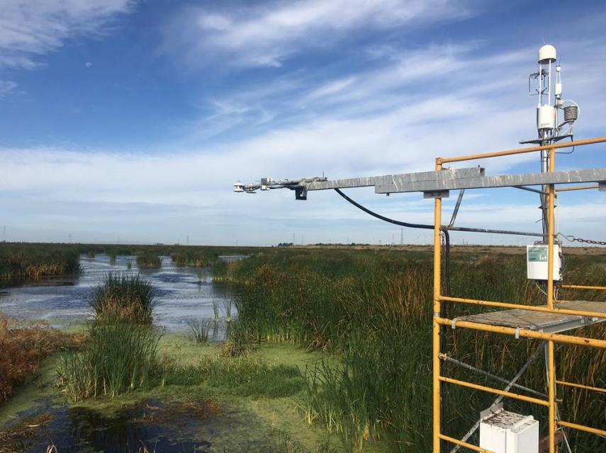
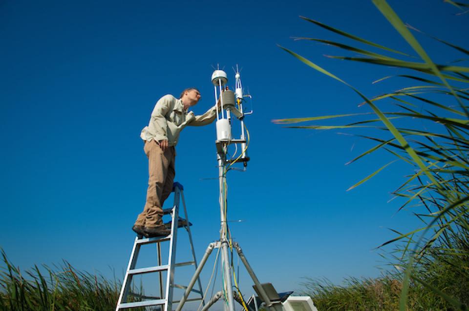
Shepherded by the Sacramento-San Joaquin Delta Conservancy, the Delta Carbon Program is near completion of the first-ever third-party verification of wetlands that quantifies the carbon emission reduction estimates from 1,600 acres of managed wetlands on Sherman and Twitchell islands operated by the California Department of Water Resources.
The aim is to use that example to encourage Delta landowners to ultimately access the state’s cap and trade market for carbon credits. About 2 million metric tons of carbon are emitted annually from the entire Delta, the equivalent of about 500,000 motor vehicle emissions.
Campbell Ingram, executive director of the Delta Conservancy, the state agency charged with fostering actions to support the Delta’s ecosystem and economy, said the land conversion idea targets about 200,000 acres of islands in the western Delta that are the most subsided and of marginal value. That amounts to more than a quarter of the Delta. About 50,000 acres of this region are under public ownership, providing an opportunity to demonstrate the viability of carbon farming to surrounding landowners.
“It’s a unique little patch of land, the subsidence of which really threatens California’s water supply,” he said. “Also, it’s a chimney that’s just rocketing carbon into the atmosphere.”
Delta islands are seen increasingly at risk of flooding and levee failures from subsidence and sea level rise due to climate change, which could pull salty water deeper into the Delta and foul exported water.
“If you can convert these soils to anaerobic conditions, you reduce the carbon emissions and you have a tendency to stop or slow way down the subsidence factor.” ~Tom Zuckerman, Delta farmer
The answer to reversing subsidence and carbon emissions lies in reverting that part of the Delta to its former marshy legacy. Instead of cultivating crops that dry the soil and exacerbate the problem, the idea is to keep the land perpetually wet, even during the hot summer months. That can be done through converting land to rice or managed wetlands. Either way, it will be a transition for Delta agriculture, Ingram said.
“With managed wetlands, you get more carbon revenue and more accretion, but it does take ag land out of production, which is not a comfortable space,” he said. “On the other hand, if the agricultural practice continues to increase the risk of levee failure, continues the huge carbon emissions and it’s not economically viable … it makes it a tough argument for people to say you’ve got to stop taking ag land out of production.”
Launching pilot projects that demonstrate the potential of reducing carbon emissions from land alterations is challenging because landowners are reluctant to pay the upfront costs when the expected revenue isn’t known, Ingram said,
Tom Zuckerman, a Delta farmer who has been working with the Delta Carbon Program on getting more rice into production, said he has seen a growth in rice production and that the benefits are evident. According to the Delta Protection Commission, Delta rice production increased by about 53 percent, from 4,874 acres in 2009 to 7,468 acres in 2016.
“It’s a double-winner situation,” Zuckerman said. “If you can convert these soils to anaerobic conditions, you reduce the carbon emissions and you have a tendency to stop or slow way down the subsidence factor.”
Zuckerman, who co-owns 1,000 acres, said he is planning to convert a portion of that acreage to rice and has heard the same from other farmers. Rice, he said, is a profitable commodity though upfront work is needed.
“The barrier is that land has to be worked on quite a bit for leveling and re-ditching so there is a capital barrier to entry on the conversion,” he said. “Once that happens, every indication is that farmers will be better off with the rice crop, both from what they get from the crop plus what they might get from carbon credits.”
The Delta’s rich, organic peat soil is wonderful for farming, but decades of cultivation have altered the natural hydrology. The peat soil is fragile and susceptible to subsidence. Decades of farming have carved out large bowls in the Delta, some of which are 25 feet below the adjacent river channels.
Crops such as corn and alfalfa require a drained root zone that exposes the peat soil to oxygen and breakdown and releases stored carbon into the atmosphere.
The Delta’s peat slows seepage from the surrounding rivers that are perched 20 to 30 feet above the land surface. When the peat gets thin, water seeps through the underlying sand, leaving areas too wet to farm. Ingram pointed to a recent study showing that in the 1980s about 500 acres were too wet to farm; now that’s about 5,000 acres.
More than 20 years ago DWR began research at Twitchell Island, near the confluence of the Sacramento and San Joaquin rivers, on how to stop subsidence. By altering the landscape and getting water back on the land, they created a tule marsh that halted subsidence and slowly rebuilt surface elevation. In the process, the state realized a carbon benefit from stopping the breakdown of the peat soils. That has become the test bed for the carbon capture protocol.
Each acre converted to marsh keeps from six to more than 20 metric tons of carbon emissions out of the atmosphere each year. Quantifying those reductions and the associated carbon credits is the key.
The first third-party verification of carbon reduction credits is expected to be completed anytime now. The final product, Ingram said, will go to the American Carbon Registry, a private, voluntary greenhouse gas registry that validates the environmental and scientific integrity of carbon offsets, where credits can be sold to realize a revenue stream.
Ultimately, the aim is for the California Air Resources Board to adopt the Delta Conservancy’s protocol into its compliance program under AB 32, the state’s landmark 2006 greenhouse gas law. Adoption is expected to raise the value of carbon emission reduction credits to as much as $180 per acre.
Each acre converted to marsh keeps from six to more than 20 metric tons of carbon emissions out of the atmosphere each year. ~Delta Conservancy
“Our expectation is that the incentive will continue to grow and can compete with the current commodities that are grown in the Delta and be a real viable option for landowners, public and private,” Ingram said.
Chris Scheuring, managing counsel with the California Farm Bureau Federation, said the Farm Bureau isn’t opposed to voluntary transactions that convert Delta farmland to other uses, but worries about the loss of good soil for farming and the impact on farmers. Ultimately, he said, it’s up to individual landowners to decide whether participating in the cap and trade carbon market makes sense for them.
“The compensation has to be there,” Scheuring said, “and it’s got to make economic sense to the farmer.”
Michelle Passero, director of The Nature Conservancy’s California Climate Program, said marketing Delta carbon aligns well with her organization’s mission of keeping the region a haven for birds.
“We are interested in exploring different practices that can help address climate change while also maintaining habitat for cranes,” she said.
Building a market for carbon credits
The Delta is an agricultural powerhouse, growing whatever commodities the market demands – corn, alfalfa, tomatoes, rice, grapes and orchard crops. However, there is concern that factors external and internal could create a quandary for future land management.
At the Delta Stewardship Council’s November meeting, Delta Watermaster Michael George expressed concern about what could happen to areas that are no longer a good investment for agriculture.
“There is a substantial risk that some of those areas [that] will not be able to be farmed profitably may be abandoned” and end up in the state’s lap, he said.
If land does default to the state, it will have to be managed, perhaps for wetlands or rice and reaping carbon benefits. AB 32 requires California to reduce its greenhouse gas emissions to 1990 levels by this year. Carbon offsets allow businesses to fund projects that reduce greenhouse gas emissions, such as the kind advocated by the Delta Conservancy.
In January, the state’s draft Water Resilience Portfolio said among its aims is to provide incentives and technical advice to Delta landowners for creating managed wetlands or cultivating rice and to “eliminate subsidence-inducing practices on state-owned lands and pursue alternative sources of revenue to support long-term land management.”
The current voluntary market for carbon emission reduction credits is about $60 per acre annually. That figure exceeds most annual per-acre leases in the deeply subsided western Delta, Ingram said, but does not fully compete with commodity prices. Furthermore, there are costs associated with converting land to managed wetlands or rice.
“It’s really hard to get farmers to say, ‘I am going to pay those upfront costs and then make less money than I make now,’” Ingram said.
Erik Vink, executive director of the Delta Protection Commission, said it’s important to prove the concept of carbon emission reduction credits in a way that sends the right economic signal to landowners.
“If you want them to farm tules, they’ll be the best tule farmers you’ve ever seen,” he told the Delta Stewardship Council in November.
A carbon credit value of between $15 and $20 per metric ton would help the economics of farming rice, said Zuckerman, the Delta farmer, adding that depending on the circumstances, revenue from carbon credits could begin look like “serious money.”
About 50,000 acres in the western Delta are publicly owned or publicly financed, raising the question of whether marketing carbon credits is a viable alternative for public agencies that need a reliable revenue stream for operations and maintenance.
Ingram said he believes once the program gets rolling, landowners — including public agencies — will see the benefit. And with a carbon credit market providing incentives to convert land to wetlands or rice, Ingram said the potential exists for increasing land elevation to help levee stability under an aggressive approach that could yield results in as few as 40 years.
While a key goal is to reduce carbon emissions, he said, the larger objectives are to stop land subsidence that ”continues to threaten the economic vitality of the region” and poses a “huge risk” to the state’s water supply.
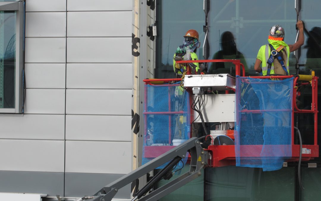
Workers put finishing touches on Denver Water’s new super-sustainable administrative complex last summer. As COVID-19 cases spread,Denver and other utilities have enacted emergency operation protocols to protect workers and to keep water treatment and delivery systems operating. Credit: Jerd Smith
As COVID-19 cases spread across Colorado, water utilities initiated emergency action plans, asking hundreds of employees to work from home to limit the virus’ spread and to help protect the workers needed to operate water treatment and delivery systems.
COVID-19 isn’t typically found in treated water systems, according to the U.S. Environmental Protection Agency and Centers for Disease Control and Prevention, because it is easily susceptible to the disinfectants used in standard water treatment systems.
“This virus is fragile,” said Jim Lochhead, CEO and manager of Denver Water, Colorado’s largest municipal water supplier. “The EPA and CDC and WHO [World Health Organization] have all put out guidance that drinking water systems that are treating water properly are perfectly safe. Our treatment protocols exceed federal and state standards and so we are doing better than we are required to do.”
Though water safety isn’t an issue in this pandemic, at least not yet, worker safety is.
In the heart of Colorado’s ski country, where COVID-19 cases have spread quickly, the Vail-based Eagle River Water and Sanitation District, as well as its sister agency the Upper Eagle Regional Water Authority, issued an emergency declaration March 13, a move that will allow them to apply for state and federal funds and extra equipment should they be needed.
The primary worry, said Eagle River District general manager Linn Brooks, is to prevent a rapid onset of COVID-19 among operations staff, something that could hamper the districts’ ability to ensure consistent water treatment and delivery.
“My biggest concern is that if it spreads quickly through our staff and we have a lot of people out, straining our capacity to do our work. Still, we could absorb a fair amount [of employee absences] before it impacts the service we provide,” Brooks said.
To date no Eagle River or Upper Eagle River District employees have tested positive for the virus nor is her district seeing high rates of absenteeism, Brooks said.
But the Eagle River District has imposed new sanitation and cleaning protocols at its plants and is requiring workers to stay home, with or without testing, if they exhibit any cold or flu-like symptoms. They can return to work only after they’ve been symptom free for at least 72 hours.
On the Front Range, Berthoud-based Northern Water, which serves more than 1 million agricultural and municipal customers, has also instituted emergency action plans, asking non-essential personnel to work from home and keeping operators on the job. Northern serves cities across the northern Front Range, including Fort Collins, Greeley, Boulder and Longmont, among others.
Northern offers workers unlimited sick leave as a matter course, while other utilities, such as Denver Water, are offering special administrative leave to employees who become ill to encourage them to remain home, allowing them to protect their personal vacation and sick time.
The pandemic has arrived just as the spring water delivery season begins. At least three regularly scheduled major water planning meetings across the state, used to inform the public and collect input on how much water should be made available for the year, have been cancelled.
“The hard part is getting the word out,” said Northern Water spokesman Jeff Stahla.
Northern’s board will make a decision April 9 on how much water will be delivered to users this year, based on final snowpack numbers and reservoir storage. But that meeting, like many others, may end up being conducted online or via conference call, Stahla said.
Colorado State of the River meetings, typically hosted by the Glenwood Springs-based Colorado River District, have also been postponed until further notice.
Back in Denver, Lochhead said his agency will remain in emergency mode “indefinitely.”
“We have calls every morning to assess. It’s a dynamic situation that changes daily if not hourly,” Lochhead said. “But in the uncertain world we’re in right now, the safety and reliability of the supply is the surest thing we have going.”
Jerd Smith is editor of Fresh Water News. She can be reached at 720-398-6474, via email at jerd@wateredco.org or @jerd_smith.
Fresh Water News is an independent, non-partisan news initiative of Water Education Colorado. WEco is funded by multiple donors. Our editorial policy and donor list can be viewed at wateredco.org. This story originally appeared on Fresh Water News on March 18, 2020.
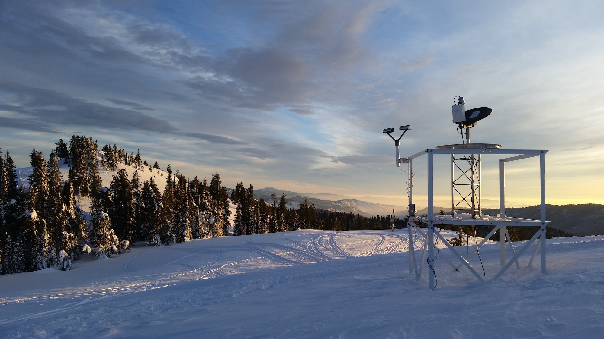
Scenes from the Seeded and Natural Orographic Wintertime Clouds: The Idaho Experiment (SNOWIE) project, which was undertaken in Idaho’s Payette Basin in winter 2017. Photo credit: Joshua Aikins
By David O. Williams
VAIL — An innovative new study conducted in Idaho and published in February seems to confirm what Vail and other Colorado ski resorts have believed for decades — that “cloud seeding can boost snowfall across a wide area if the atmospheric conditions are favorable.”
“This is a revelation. We can definitely say that cloud seeding enhances snowfall under the right conditions,” said Sarah Tessendorf, a scientist at the National Center for Atmospheric Research in Boulder and co-author of a new paper on the research conducted by scientists from the University of Colorado Boulder and University of Wyoming, among others.
Cloud seeding uses ground-based generators to disperse dust-sized silver iodide particles into clouds so that ice crystals can form on those particles and fall to the ground in the form of snow. Scientists, water managers and ski industry executives say it’s precipitation that would otherwise stay in the clouds, so cloud seeding is an environmentally safe way to enhance snowfall.
But the efficiency of cloud seeding has so far been hard to prove. Tessendorf said previous cloud seeding studies were unable to achieve statistically significant results because the natural variability of the weather was too great and demanded a larger sample size than could be reasonably obtained, for financial reasons.
In winter 2017, the National Science Foundation, which sponsors NCAR, teamed up with the Idaho Power Company to conduct a field study called SNOWIE (Seeded and Natural Orographic Wintertime Clouds — the Idaho Experiment).
SNOWIE used supercomputing technology to develop a new computer model to simulate cloud seeding, as well as new measurement capabilities, such as a high-resolution cloud radar on a Wyoming research aircraft that can see previously invisible cloud features. Researchers also located mobile radars on mountain ridges north of Boise to see clouds not visible to stationary National Weather Service radars that are blocked by the mountains themselves.
The scientists then used airborne seeding instead of ground-based generators because the silver iodide dispersed downwind from the aircraft in a zig-zag pattern, which is a very unnatural pattern for precipitation to form.
That allowed the scientists “to unambiguously detect the impact of cloud seeding in these clouds using the mobile and airborne radars,” Tessendorf said. “This had never been done before. In the three cases we report on, there was negligible natural snow falling, so the zig-zag pattern was able to be detected very clearly and tracked to the ground to quantify the snow reaching the ground due to seeding.”
One of the examples cited in a press release accompanying the study was a cloud-seeding flight on Jan. 19, 2017, that generated snow for 67 minutes, dusting about 900 square miles with a tenth of a millimeter of snow beyond what was falling naturally.
“This was barely enough snow to cling to the researchers’ eyelashes,” the release reads, ‘but it would have stayed in the air if not for cloud seeding.”
“We tracked the seeding plume from the time we put it into the cloud until it generated snow that actually fell onto the ground,” said Katja Friedrich, a University of Colorado Boulder professor and lead author of the new study.
Scenes from the Seeded and Natural Orographic Wintertime Clouds: The Idaho Experiment (SNOWIE) project, which was undertaken in Idaho’s Payette Basin in winter 2017. Photo credit: Joshua Aikins
Finding the ideal storms
Dave Kanzer, deputy chief engineer for the Colorado River District, helps oversee a system of 25 ground-based cloud-seeding generators in the central Colorado region that includes Grand, Summit, Eagle and parts of Pitkin County. Nearby generators include one atop Arrowhead and another above Camp Hale.
Kanzer said storms from the north and northwest, which tend to be colder, are ideal for cloud seeding, with temperatures in the clouds no higher than 21 degrees Fahrenheit and no lower than 5 degrees Fahrenheit. If the clouds have the right temperature range and the right moisture levels but lack sufficient particles for ice crystals to form, that’s where cloud seeding comes in.
“We take advantage of the first two and we add the proper amount of particulate matter to enhance the snowfall and precipitation … and that accumulates in the snowpack somewhere in the range of between 5 and 15% on a per storm basis when those conditions are met,” Kanzer said. “And that helps to increase the water yield of the snow sheds in the range of 1 to, 4% of water on a seasonal basis.”
In winter 2017, the National Science Foundation, which sponsors NCAR, teamed up with the Idaho Power Company to conduct a field study called SNOWIE (Seeded and Natural Orographic Wintertime Clouds — the Idaho Experiment). Photo credit: Joshua Aikins
A tool to maintain snowpack
The Colorado Department of Natural Resources regulates cloud seeding, permitting operations in nine different parts of the state. The operations in the central zone, at the headwaters of the Colorado River, are funded by a wide range of groups, including Front Range utilities and water districts that divert Western Slope water, including Denver Water and Northern Water.
The Colorado River District spends around a $150,000 a year contracting with Western Weather Group to run the program, which Kanzer said is about the same amount Vail Resorts spends on the program for its four Colorado ski areas – Vail, Beaver Creek, Breckenridge and Keystone.
Vail Resorts declined to comment for this story.
Kanzer presented on cloud seeding at a November Eagle River Watershed Council meeting in Avon, where a few of the 50 or so participants got heated in their questioning of the environmental safety of the process.
Kanzer said cloud seeding is safe, using inert silver iodide that cannot be detected in the environment after it’s released into clouds. He added the process could become increasingly critical to maintaining mountain snowpack as the climate changes.
“It’s one tool that we can use to mitigate or adapt to the changes that we have not only predicted but are starting to experience with shorter snow-covered seasons,” Kanzer said. “And so (cloud seeding) helps us extend that time or at least forestall the reduction.”
Aspen Journalism collaborates with The Vail Daily and other Swift Communications newspapers on coverage of water and rivers. This story ran in the Feb. 25 edition of Aspen Journalism and The Vail Daily.
This story was supported by The Water Desk using funding from the Walton Family Foundation.
This year, tribal nations enter negotiations over Colorado River water.
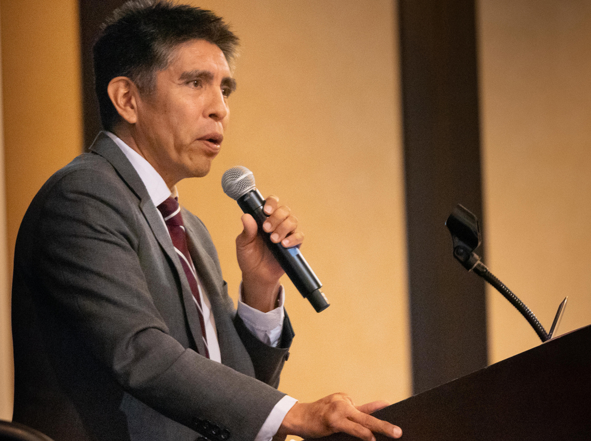
Daryl Vigil, water administrator for the Jicarilla Apache Nation, has pushed for increased tribal participation in Colorado River renegotiation discussions.Courtesy of Bob Conrad
The Colorado River Basin is the setting for some of the most drawn-out and complex water issues in the Western U.S. In 2019, the Colorado River Drought Contingency Plan — a water-conservation agreement between states, tribal nations and the federal government for the basin, now in its 20th year of drought — passed Congress. This year, it goes into effect.
2020 will also see the start of the renegotiation of the Colorado River Interim Guidelines. The guidelines, which regulate the flow of water to users, were created in 2007 without tribal consultation and are set to expire in 2026. The 29 tribal nations in the upper and lower basins hold some of the river’s most senior water rights and control around 20% of its annual flow. But the tribes have often been excluded from water policymaking; around a dozen have yet to quantify their water rights, while others have yet to make full use of them. Most of the tribal nations anticipate fully developing their established water rights by 2040 — whether for agriculture, development, leasing or other uses. Drought and climate change are still causing shortages and uncertainty, however. Already, the Colorado River has dropped by about 20%; by the end of this century, it could drop by more than half.
High Country News spoke with Daryl Vigil (Jicarilla Apache, Jemez Pueblo and Zia Pueblo), water administrator for the Jicarilla Apache Nation. Vigil, the interim executive director of the Ten Tribes Partnership, helped co-facilitate the Water and Tribes Initiative, coalitions focused on getting increased tribal participation on Colorado River discussions. Those efforts are critical, Vigil says, “because left to the states and the federal government, they’ve already proven that they will leave us out every time.”
HCN and Vigil spoke about “the law of the river” — the colloquial term for the roughly 100 years of court cases, treaties, agreements and water settlements that govern the Colorado — as well as tribal consultation and climate change.
This interview has been edited and condensed for length and clarity.
High Country News: Sometimes it can be hard to really understand the core value of water, because it gets so caught up in things like policies and laws and bureaucratic language. Could you boil it down a bit and explain, at the core, what’s so important about this?
Daryl Vigil: Through the Water and Tribes Initiative (in 2018), we did over a hundred interviews of all the major stakeholders in the basin: states, water providers, tribes, NGOs, conservation groups. And it was pretty amazing, to find out that when you talk to all these folks, almost universally they’re all committed; they have a personal relationship to the river as a living entity that needs to be sustained. And so there’s two different mindsets looking at ’07 guidelines and some of the policy that’s been created around the river. One really looks at the Colorado River as a plumbing system, getting water to people who need it, versus the other end of the spectrum — when you start to look at tribes and others who have similar values, who look at it as a living entity, who look at it as an entity that provides life. And so we started to try to articulate traditional, cultural values and integrate that into current policy so that people can understand. Because we know most people want to see a healthy, sustainable Colorado River, but they also have their constituencies that they protect. And so, how is it that we bridge that divide? Because people really do care about the basin, and they really do want healthy environments and healthy ecosystems. And so that’s proven part of the conversation that we were having — that the next set of guidelines absolutely needs to be able to capture not only the water-delivery issues that already are at the forefront, but really start to address the cultural, environmental, traditional values of the Colorado River and integrate that into the next set of planning. Because if we don’t, this system cannot be sustained.
HCN: How does climate change figure into the discussion?
DV: We’re already seeing the impacts. And I think that’s something that absolutely has to be considered in the planning of the future, because right now — with 41 million people in the basin — as of 2010, the imbalance between supply and demand is already a million acre-feet. It’s projected, according to the basin study, to be 3 million acre-feet by 2060. We continue to act surprised when something new comes about in terms of a fire or a flood or an incredible drought. We’re making an impact on this planet, and it’s not a good one. That’s where, with the Ten Tribes Partnership, (we’re) really trying to make sure that we integrate those traditional, cultural values and spiritual values that the tribes have for the river as we move forward. Because if we’re not going to address it, it looks pretty catastrophic to us. And so I think, when we start talking about climate change, absolutely pushing to make sure that we’re thinking about a mindset of how we fit into nature, rather than nature fitting into us.
HCN: These kinds of discussions, compromises and negotiations can often, especially around water in the West, go on for decades. I’m curious what gives you momentum to keep working at it and putting so much energy into it.
DV: A few different things. You know, those hundred-plus interviews that we did, we got to know people on a real personal basis. We got to know who they are and their commitment — many of these people have had decades working in the Colorado River Basin and doing the best that they could, given the structure. And everybody understands and agrees that the current system is not sustainable, and it doesn’t work; it’s not inclusive of the voices that need to be included into this process. And so that gives me great hope. And then you see things like the pulse flow, where they got water all the way to the Sea of Cortez. And to look at the faces of those Mexican kids who had never seen water in the Colorado River in their whole life come out, and just the wonder and the magic in their eyes of seeing what water does.
And then we just recently had our second basin-wide workshop and gathering up in Phoenix. We had a hundred-plus of the major stakeholders: states, feds, water providers, tribes and four tribal chairman present at this particular meeting, which is just huge, a bunch of people all in this room all talking about their joint commitment to the river. It’s moving to me because, I mean, I think that’s what it’s going to take.
HCN: Every tribal nation is different, but how might a tribal nation view water similarly or differently than a city or a state or the federal government in terms of water and management?
DV: That’s the thing that we’re really trying to create awareness of. Because in the Colorado River Basin alone, you have 29 distinct sovereign entities — geographically, culturally, languages, and mindsets and traditions and culture in terms of how they think about the river. A lot of it’s really about the same, but in terms of the reverence and the spiritual connection that most tribes have, they look at it in different ways. For instance, invasive species of fish: You get tribes who are really aggressive about wanting to remove them because they’re not part of the natural environment that was always there. Then you get other tribes who are just like, eh, who cares and it’s not on their radar. And that’s why it’s important that a conversation about the next set of guidelines for the Colorado River has to include all 29 tribes — in terms of at least the opportunity to participate and at least having the information to determine whether they want to or not.
HCN: What are some big things that you would like people to better understand about the discussions around water in the Colorado River Basin?
DV: I would like them to understand, from a tribal perspective, the incredible role that tribal water already plays in the basin. The other thing I would like people to understand is that this current law of the river is not sustainable. At some point in time there’s collapse. And I think if we don’t address it quickly, that collapse could happen sooner than later. And I really would like to have them understand that the way that the law of the river is structured — upper, lower basins, and how they’re managed differently, and how there’s different requirements and how states are engaged — it’s really complex and doesn’t make any sense, and, ultimately, I don’t think it’s going to get us where the broader consensus wants us to go in terms of a healthy, sustainable river, and still provide water to all living creatures and plants in the basin.
HCN: Specifically, what is it that tribal nations are bringing to the conversation that was lacking in the 2007 agreements?
DV: I think absolutely a point of view about the sacredness of the river that most people really do share, whether they’re tribal or not. And then the other thing is the unique role that tribes are going to continue to play in the West — the large land areas and our resource development and how we move forward. It creates this mindset, in my mind, of building a pathway of who we want to be in the future. But a huge thing, too, is tribes bring certainty to the table. You know, it’s like, wow, what if we negotiated together about being able to move water where it needs to move, and work from a standpoint of collaboration and need rather than protect, defend and win, lose.
HCN: That’s a good point. Because that’s how water is so often talked about, as somebody versus somebody.
DV: And I think that’s what the law of the river does. It’s contentious, and it automatically puts you in a position to protect and defend. And if that’s the foundation we’re operating from, what does that get us? It’s just going to get us this recurring, vicious cycle that we’ve been stuck in. The work that we’re doing at the partnership and Water and Tribes Initiative hopefully has broader implications in terms of tribal sovereignty, and looking at tribal sovereignty from the standpoint of an opportunity to create your future.
Water plays a lead role in the state’s political theater, with Democrats and Republicans polarized, farmers often fighting environmentalists and cities pitted against rural communities. Rivers are overallocated through sloppy water accounting. Groundwater has dwindled as farmers overdraw aquifers. Many communities lack safe drinking water. Native Americans want almost-extinct salmon runs revived. There is talk, too, of new water projects, including a massive new tunnel costing billions of dollars.
Scientists say climate change will bring more unpredictable weather, warmer winters and less snowpack in the mountains. These challenges and some ideas for remedies are outlined in a new plan, called the California Water Resilience Portfolio, released by Gov. Gavin Newsom in January to a mix of praise and disappointment.
Below, an explanation of the state’s water development — as well as the challenges, today and tomorrow, of providing water for California’s people, places and things.
It originates as rain and snow. Some falls in Oregon and drains into the Klamath River, and some falls in the vast drainage of the Colorado River. But most of it lands in California — about 200 million acre-feet on average per year. (An acre-foot is 326,000 gallons, what an average household consumes in between six months and two years.)
To understand what that volume means, imagine a skyscraper 38,000 miles tall. Yes, miles tall, not feet. Now, fill it with water. That is California’s average annual precipitation.
So, where does all this water go? More than half evaporates, leaving about 75 million acre-feet either frozen in mountains or filling rivers, lakes and reservoirs. Some sinks into the ground.
About half of the 75 million is diverted to human uses, and half is left in watersheds, what is referred to as environmental “use” of water.
Source: Daniel J. Hoover, et al. Map of California showing the average annual rainfall from 1981–2010. Used with permission.
How does this water get to us?
Because precipitation falls unevenly in California — almost ten feet per year drenching parts of the Coast Range and just several inches falling in deserts — water agencies have found ways to spread the resource.
A complex system of dams, reservoirs, pumping stations and about 2,000 miles of canals supplies water to Californians that originated in the Rocky Mountains, the Sierra Nevada and the Cascades.
For instance, when an 11-mile tunnel was drilled through the mountains of California’s North Coast in 1960, water that naturally flowed to the salmon streams and redwoods was diverted to San Joaquin Valley orchards and other farmland. This Trinity River project is one of many ambitious engineering projects that have brought water to Los Angeles swimming pools, San Diego lawns, Kern County crops and the taps of about 30 million people.
Here are our major delivery systems:
Between rain and snow, the state’s drainage basins receive an average of about 200 million acre-feet of precipitation each year. Source: California Department of Water Resources
The federal Central Valley Project uses 20 reservoirs and 500 miles of canals to send water from the Sacramento, San Joaquin and Trinity basins into the San Joaquin Valley and the Bay Area. It provides water for about 3 million acres of farmland.
The State Water Project transports water via more than 700 miles of canals from the same river systems to cities and farms throughout the state, as far as San Diego. In all, it supplies 27 million people and 750,000 acres of farmland.
Another 4 million acre-feet per year flow via a 242-mile aqueduct from the Colorado River to Southern California farmland and cities.
Water from the Sierra Nevada travels via canals as far as 160 miles to San Francisco and surrounding cities, and Los Angeles imports it from the Eastern Sierra in a canal system more than 400 miles long.
About 40 percent of all water used in California is pumped from underground basins in an average year. This share increases during drought years.
How much water do we use?
On average, each Californian used 85 gallons of water at their homes every day in 2016. By national standards, that’s right about in the middle. In Idaho, each person on average uses 168 gallons a day, the national high. Residents of Maine use the least, about 55 gallons.
Coastal city dwellers, especially in the cooler, rainier north part of the state, use the least water, while residents of inland suburban areas with spacious lawns, gardens and pools use much more.
In one water district in north San Diego County, each resident uses more than 500 gallons per day during the hottest summer months.
Graphic by Pacific Institute and used with permission. Source: California Department of Water Resources Water Use Balances for Planning Areas, 1998–2010 (Department of Water Resources 2014) and US Census Bureau (2010 population by Census Tract)
How much is used by homes compared to farms?
Even multiplied by 40 million people, the amount of water used by homes amounts to relatively little. Farmland uses three to four times more than people use for cooking, drinking, washing, gardening and landscaping.
California’s farmers and ranchers irrigate their land with about 30 million acre-feet of water each year (mostly from surface supplies but also from underground). Residential water use runs about 8 million acre-feet per year.
Another 40 million acre-feet or so flows through river systems, supporting wildlife. That’s on average, spiking in wet years and ebbing during droughts.
What are farmers growing with all that water?
Farm products generated $50 billion in sales in 2018, making agriculture the state’s most valuable industry. The biggest money makers are dairy, grapes and almonds.
Almond groves cover more than 2,000 square miles, mostly in the Central Valley. Because the trees occupy so much land — more than any other crop — environmentalists argue that they guzzle too much. They use an estimated 3 to 4 million acre-feet per year.
But other major crops require plenty of water, too. Alfalfa often uses more than 5 million acre-feet per year, although acreage has been declining. Open pasture for grazing takes up another 3 million acre feet or so. Rice paddies are annually flooded with almost 3 million acre-feet per year (though much eventually returns to the environment).
What are the environmental impacts of our water use?
In addition to economic prosperity, water diversions have brought environmental consequences.
Mono Lake, millions of years old, dropped 25 feet, nearly destroying its scenic ecosystem, when Los Angeles diverted the eastern Sierra’s water. The San Joaquin River nearly dried up. Yosemite’s Hetch Hetchy disappeared under reservoirs. And the Colorado River, in most years, is empty before it reaches its estuary at the Sea of Cortez.
Dams blocked migration routes of salmon and steelhead, and then diversions, levee construction and development created poor conditions for the surviving fish. Coho salmon, steelhead and green sturgeon are listed under the Endangered Species Act, and many salmon runs are expected to vanish this century. In addition, the tiny Delta smelt is almost extinct. The totuava, an ocean fish that can reach 300 pounds, once spawned in great numbers in the Colorado River Delta but is now scarce.
Much of the conflict over California’s water focuses on the Endangered Species Act. To protect species, pumping from the Delta is reduced. This creates strife between environmentalists and growers. Some biologists say more water needs to be left for river fish as well as San Francisco Bay creatures such as crab, herring and halibut.
The Delta is where the Sacramento and San Joaquin rivers meet, east of San Francisco Bay. It is the hub of California’s water supply and conveyance system.
In an average year, pumps withdraw about 5 million acre-feet from the estuary. That’s about one-fourth of all the water that flows into the Delta. A pair of canals transport it to semi-arid regions, including San Joaquin Valley farmland and Southern California cities.
This use, combined with other factors like invasive species and water pollution, has strained the Delta’s ecosystem.
It’s not just fish that are in trouble. The levees are old and at risk of breaking, especially as sea level rises. A major levee breach could allow seawater to flood pumping stations, spelling disaster for farmers and millions of people.
Adding to the pressures is a recent pact to use less water from the Colorado River, which is divided among seven states. These battles are intensifying as demand increases and supplies shrink. This could force Southern California to look for more water from other sources, like the Delta.
Will a tunnel solve these problems?
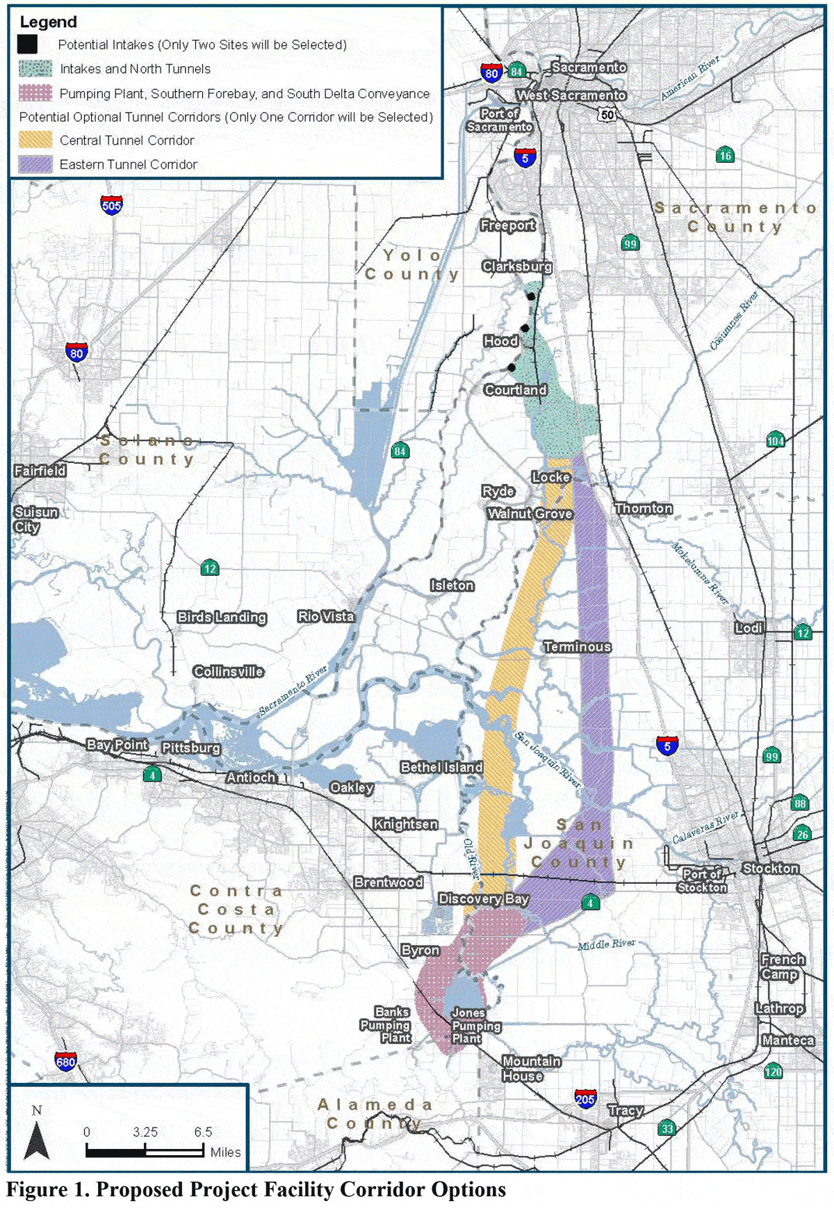
One proposed solution to the Delta’s water woes is to build a 35-to-40-mile-long tunnel that starts upstream of the Delta, near Sacramento, and routes water around the Delta before reconnecting with the southbound canal system.
Former Gov. Jerry Brown promoted a two-tunnel project for eight years without success. Newsom has downsized the plan to one tunnel and hopes to begin construction within three years.
Currently, major Delta pumps pull water from the heart of the estuary. This causes obstacles for migrating fish. In addition, the pumps are vulnerable to saltwater during low river flow and high ocean tides. A tunnel would shift water diversion miles upstream, which might alleviate these problems. Intakes would be several feet above present-day sea level, and the rivers would flow through the Delta and out to sea, which helps migrating fish.
But the tunnel plan is extremely controversial. Many opponents worry it could harm the ecosystem by diverting too much water before it reaches the estuary. Excessive diversions could also allow saltwater to threaten farms and communities in the Delta area that rely on freshwater. Moreover, moving the diversion point upstream to avoid rising seas simply kicks that can down the road a few decades.
The tunnel will cost an estimated $11 billion. Water suppliers, like the Metropolitan Water District of Southern California, which supports the project, would likely cover the cost, although details remain unsettled.
The proposed Delta tunnel could take one of two different paths — the Central Tunnel Corridor or the Eastern Tunnel Corridor. Source: California Department of Water Resources
Can’t we just pump more groundwater?
Many farmers rely on groundwater, especially in dry years. Some Southern California cities also get as much as half of their supply from wells. But no California agency has been tracking exactly how much is used or who uses it, even though nearly every other state regulates this resource.
The free-for-all has led to farmers in many areas pumping groundwater faster than the natural recharge. Water tables have rapidly dropped and, in some communities, homes have run out of water. During the 2012-to-2016 drought, about 3,500 domestic wells went dry.
Also, when coastal aquifers are heavily tapped, saltwater creeps inland. In central and Southern California, water managers have to inject freshwater into aquifers to stop the saltwater intrusion.
San Joaquin Valley farmers have pumped so much water that some areas have subsided by 20 feet or more. This damage cannot be undone, and the water storage capacity is lost forever.
The law requires local agencies to begin monitoring and regulating groundwater so that withdrawals don’t exceed inflow. But this stabilization may not happen anytime soon, since the law sets a sustainability deadline of 2040.
Many farmers are uneasy because it will reduce water supply and force land out of production. Some experts say farmers will have to fallow between 500,000 and a million acres. These changes are likely to hit hardest in the San Joaquin Valley.
Farmers have ideas to cope: One is to pay some not to grow anything and leave their water allocation for someone else. Another is to develop water markets to buy and sell water.
Are we facing another drought this year?
After a soggy December, California has entered 2020 almost bone-dry.
January and February are typically the wettest months in most of the state, and the current conditions suggest that California will face another drought. As of Feb. 18, 60 percent of the state was abnormally dry.
A drought would damage the environment and economy, particularly because the state has not recovered from the 2012-2016 drought. Groundwater tables remain overdrawn, and with below-average Sierra Nevada snowpack, water reserves are unlikely to rebound anytime soon.
A rainy, wet March — a “miracle March” — could help, but if dry conditions persist, it will likely bring more feuds between frustrated water users.
Is our water safe to drink?
Some of California’s aquifers, including large basins in the San Gabriel and San Fernando valleys, are contaminated with chemicals.
One of the greatest dangers is nitrates that leach from fertilizers, manure and sewage. Pesticides, oil waste, industrial solvents and other contaminants also pollute groundwater. The Community Water Center, a social justice group, estimated that more than one million state residents are exposed to unsafe drinking water each year.
What if we just recycled more water?
In many communities, treatment plants collect used water, purify it and send it back into the delivery system, mostly for irrigation and industrial purposes. In 2015, California recycled about 714,000 acre-feet, primarily for landscaping and irrigation. Sixteen percent, about 114,000 acre-feet, was used to recharge groundwater basins.
Water recycling is often termed a “drought-proof” supply, and state initiatives aim to be reusing about 2.5 million acre-feet annually within a decade.
How will climate change affect our water supply?
While scientists don’t know if California will see more precipitation in the future or less, average temperatures will increase. This will worsen water storage and supply issues, for a variety of reasons.
Warmer winters mean less precipitation will fall as snow and more as rain, which will quickly fill reservoirs and force managers to release water from dams. With less snowpack, flow to reservoirs could slow to a trickle between spring and fall.
Research also has shown that warming, by increasing evaporation, will cause a devastating 35 percent flow reduction this century in the Colorado River, one of Southern California’s key sources.
Rising sea level also threatens freshwater supplies. Seawater could eventually flood Delta pumping stations, spoiling the water supply of millions of people and seeping into coastal aquifers.
Will technology help?
It probably will. Consider desalination, which removes salt from seawater. It seems like something between a miracle and a no-brainer. But desalination is very expensive, and only a few small plants have been built in California. It also can generate greenhouse gases and requires disposal of brine. As some skeptics have joked, desalination is a promising future technology — and it probably always will be.
Water recycling looks more promising, and its technologies are advancing. State policies call for more sophisticated systems that purify reclaimed water to a drinkable state. Only a few such facilities exist in the world.
Capturing stormwater could be cheaper. Diverting runoff into treatment systems or storage basins could, according to one analysis, add as much as 630,000 acre-feet each year in coastal cities.
And if times get really hard, water might be harvested from fog by placing fine mesh screens on seaward bluffs and dunes. Stay tuned.
Wouldn’t it just be cheaper and easier to consume less water?
Yes. For all the high-tech ways to fortify and expand our supply, the easiest, cheapest and potentially most effective solution is to use less water to begin with.
The Pacific Institute, a think tank in Oakland, says that conservation could cut California’s water use half.
In fact, conservation has already helped. In Southern California, total urban demand — residences, businesses, institutions and parks — exceeded 200 gallons per person per day in the early 1990s. Today, it’s about 130 gallons per person per day. That means a population that has grown by several million people has reduced water use by more than a third.
Are farmers wasting water?
Some farmers use water inefficiently, but in general, they try to squeeze as much “crop per drop” as possible. Many growers have retired flood irrigation and wasteful sprinklers and adopted drip irrigation systems. They also use technology that autonomously monitors soil moisture and remotely opens and closes water valves.
Almond growers, for example, grow each nut with one-third less water than 20 years ago. However, because acreage has more than doubled, the industry still uses more water than it did.
How is President Trump affecting California’s water problems?
In 2019, the Trump administration introduced a plan that critics say weakens Endangered Species Act restrictions on pumping water from the Delta.
Many farmers welcome the proposal since it could increase their annual water deliveries by half a million acre-feet or more. But environmentalists call it “an extinction plan” for winter-run Chinook salmon and Delta smelt. They say it will allow more diversions during key migration periods, increasing the odds the fish will be sucked into the pumps, and it may affect spawning salmon. Newsom has threatened to sue the federal government to halt the plan.
What’s the governor doing?
The Newsom administration created a “Water Resilience Portfolio” of more than 100 ideas. It focuses on four areas: diversifying water supplies, protecting the environment, improving storage and conveyance systems, and preparing for climate change and natural disasters. A Delta tunnel is a priority, as is a new Sacramento Valley reservoir.
The portfolio stresses the need for more underground storage, as well as desalination and farming programs that build healthy soils that retain more water. It also recommends identifying minimum flow rates to protect and restore salmon runs. It warns, too, of a future climate that will challenge existing storage systems.
Overall it’s a long to-do list. Jeffrey Mount of the Public Policy Institute of California said the portfolio was “a Herculean effort,” but it doesn’t mandate action, it just makes recommendations. “This is a plan to plan,” Mount said.
Longform Story CSS Block
This explainer was supported by a grant from The Water Desk, an independent journalism initiative based at the University of Colorado Boulder’s Center for Environmental Journalism.
With population growth around Denver prompting fierce competition for water, investors want to import a new supply from the San Luis Valley, but many farmers and ranchers who depend on that water are opposed to the plan.
This video story was produced for The Water Desk by public television’s “This American Land.” Reporter: Jerd Smith. Producer and Editor: Dave Timko


