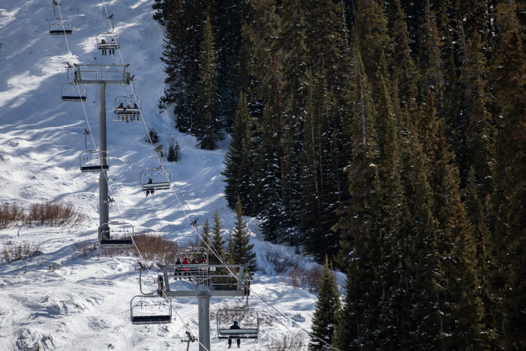
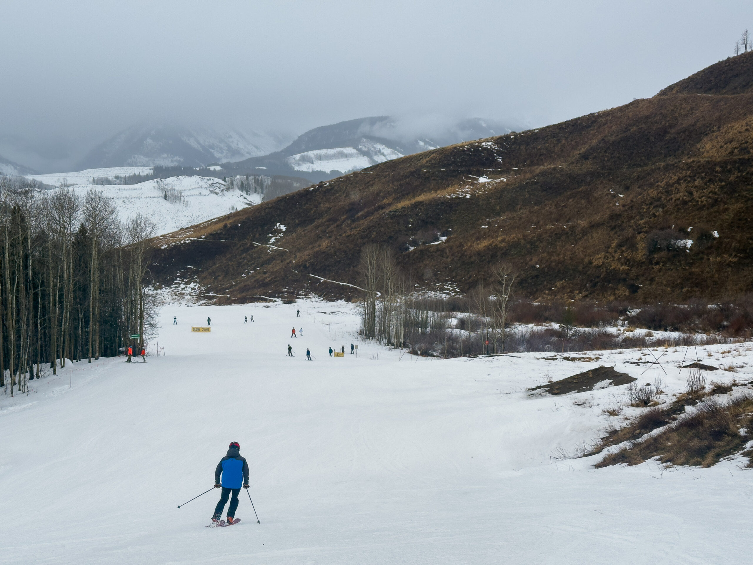
In early March 2026, bushes and vegetation stick out from under the snow under a lift at Arapahoe Basin. (Annie MacKeigan/The Water Desk)
Call it the winter that wasn’t.
Throughout Colorado a record-warm and dry winter has come to a close. Attention now pivots to spring and the potential for additional snow to allay increasing drought concerns. Though, there appears to be little relief in sight.
The Denver-metro area went months without measurable snowfall this winter. The city’s daytime temperatures often surpassed 60 degrees. Hikers and trail runners rejoiced over the warm weather while grumbling skiers lamented their underused season passes.
In the state’s Rocky Mountains snow accumulation was sluggish, as warmer than normal temperatures led to midseason snowmelt, and caused more precipitation to fall as rain instead of snow. A persistent mid-March heatwave kicked off rapid snowmelt. Colorado’s snowpack, and in the broader Colorado River basin, set new record lows throughout winter. T-shirt weather wasn’t just confined to lower elevations either. The high country too experienced balmy days and nights.
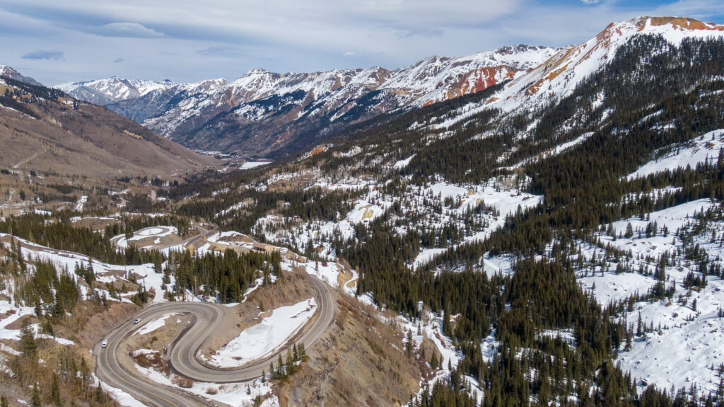
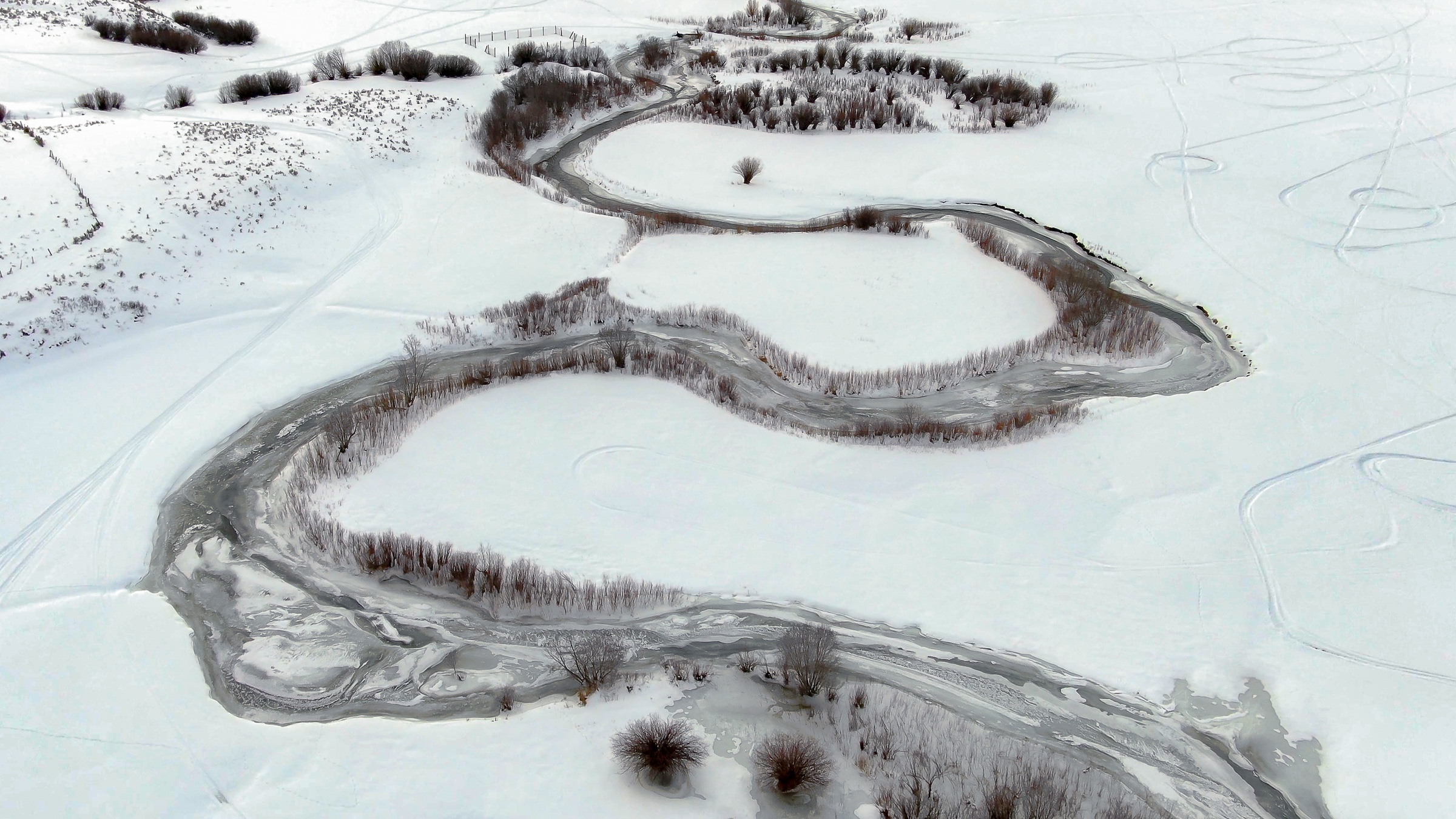
Spring snowmelt is underway near Red Mountain Pass in Colorado’s San Juan Mountains on March 14, 2026. (Mitch Tobin/The Water Desk)
The mild year has already led to lifestyle changes for Colorado residents, and threatens to do even more. Ski resorts are closing early, ranchers are worrying about the security of their irrigation supplies, and water managers are considering contingency plans if such conditions persist.
This year, powder days that rev the state’s ski economy were replaced with sunshine. Recreation is not the only industry under threat from rising temperatures and low snowpack. The state’s agricultural economy hinges on access to snowmelt.
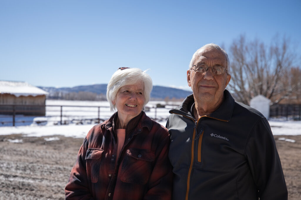
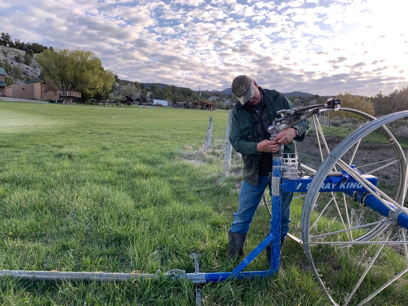
Marsha and John “Doc” Daughenbaugh call the Rocking C Bar Ranch near Steamboat Springs home. Marsha is a third generation rancher in the area, and the couple have passed the business off to their two children. They still worry that if such dry conditions continue, it would “seriously affect our ability to keep going,” Marsha said.
Marsha and Doc Daughenbaugh of Rocking C Bar Ranch, west of Steamboat Springs, Colo., say dry winters call into question their ranch’s longterm viability. (Annie MacKeigan/The Water Desk)
A well-welcomed snow system worked its way through parts of the state in early March, providing the nearby Steamboat Ski Resort a self-reported 6 inches of new powder. But it quickly melted, and the Daughenbaughs were ankle deep in mud come midday.
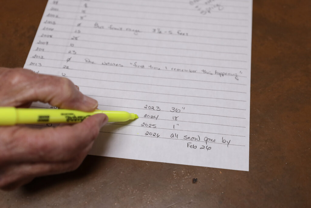
Doc has long made a habit of measuring inches of snowpack in the ranch’s meadow each year on March 20, right around the spring equinox. Few of his recordings—which began in 1989—noted no snow.
The most sobering of Doc’s notations is also the most recent. During a visit in early March, the entry read, “all snow gone by Feb. 26.”
The Daughenbaughs have collected snow measurements on their ranch near Steamboat Springs since 1989. (Annie MacKeigan/The Water Desk)
The noticeably scant snow is not the only observation the Daughenbaughs have made this year. Robins, geese and sandhill cranes had already returned to the family’s ranch by early March, not usually due back until the first week of spring.
Marsha, who has lived in Steamboat since 1953, recalled “three-wire winters,” when snow would build up to the third wire on the barbed-wire fences that surrounded their property. “They were really a common thing,” she said.
Their main concern is that any snowpack that does accumulate this spring will travel down the mountains fast, due to warm temperatures and limited reserves, which means less water availability sooner in the year for high country ranchers like themselves.
South of the Daughenbaughs, skiers and snowboarders in Summit County are seeing their seasons cut short.
At its summit, Arapahoe Basin is one of the county’s highest ski resorts in elevation. But instead of the high elevation benefitting the mountain, it has become somewhat of a disadvantage. According to Doug Petrick, a skier from Erie, Colo. who frequents Arapahoe Basin, the back side of the mountain was extremely icy because of its exposure to this year’s unseasonably high winds.
In addition to Arapahoe Basin, Petrick also skis at Breckenridge, Keystone, Vail, Copper and Winter Park. Petrick has recorded 30 days of skiing this season which is on par for seasons past. However, the difference in conditions this year has been noticeable.
“There has been a lot of exposure of rock and dirt. The snow is not enough to cover the mountain,” he said. “My skis have taken more of a beating due to the exposed rock and dirt.”
While Arapahoe Basin benefits from high elevation terrain, other Colorado resorts struggled to stay viable. Powderhorn in Mesa County, Sunlight in Garfield County, and Ski Cooper near Leadville all shuttered before their scheduled closing days this spring.
Because skiing is his favorite winter activity, Petrick is holding out hope for more snowfall and a better next season. “But if next year is the same or worse,” he posed, he may start to worry.
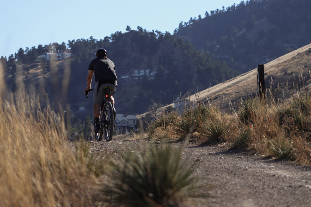
Runners, hikers and bikers recreated in t-shirts and tank tops on Foothills South Trail in Boulder, Colo., on March 4, 2026. The month is typically Colorado’s snowiest. (Annie MacKeigan/The Water Desk)
Petrick is not the only one holding out hope for the future. Colorado’s cities too look seasons ahead to ensure they have enough water to meet their needs. Matt Fater, senior director of infrastructure engineering for the City of Fort Collins’ water utility, is hopeful for more spring snow. Without it, the city may have to tap into existing water storage.
“We’re not in a crisis mode yet,” Fater said. “We’re watching it closely. We do have short term and long range plans when it comes to drought planning.”
The long range planning includes a policy that requires the city to be prepared for a 1-in-50 year drought. In the case of a severe drought, the city pulls water from different storage reserves that accumulate during particularly wet years. Fater reinforced the need for additional storage in the city, to “make sure we can meet the demand of our community.”
Snowpack that supplies the Cache La Poudre River has lagged well below average this year. The river is a main water source for the city of Fort Collins. (Annie MacKeigan/The Water Desk)
Other cities aren’t waiting. Denver Water has already let its customers know they’ll be restricted on their outdoor summer watering this year. In Erie, residents who flouted the town’s voluntary outdoor watering restrictions now face the potential of being cut off completely, according to CBS Colorado. And planning for the potentially hot and dry summer ahead has led Governor Jared Polis to activate a statewide drought task force too.
Snowpack in the high country acts as a battery for water availability, Fater said. Without enough snowpack to “recharge” those additional storage sites, a future drought could result in limited water availability and potential restrictions in the city.
Ranchers, skiers and water users throughout the state were hopeful that March would bring a miracle, and the snowpack deficit would decrease after a few big storms. But with a warm winter transitioning to an even warmer spring, the hopes of a few high-powered snowstorms are fading.
This story was produced and distributed by The Water Desk at the University of Colorado Boulder’s Center for Environmental Journalism.
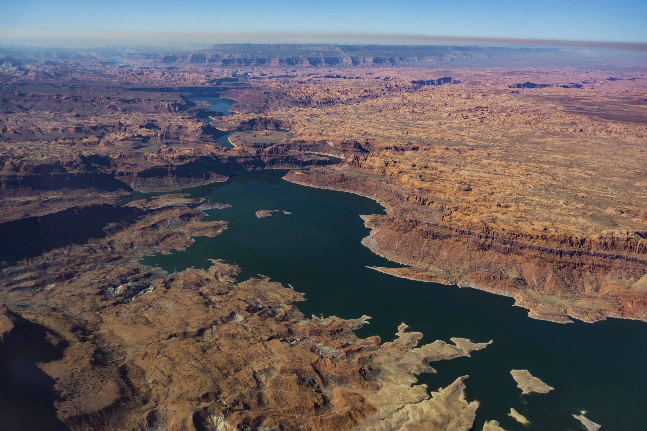
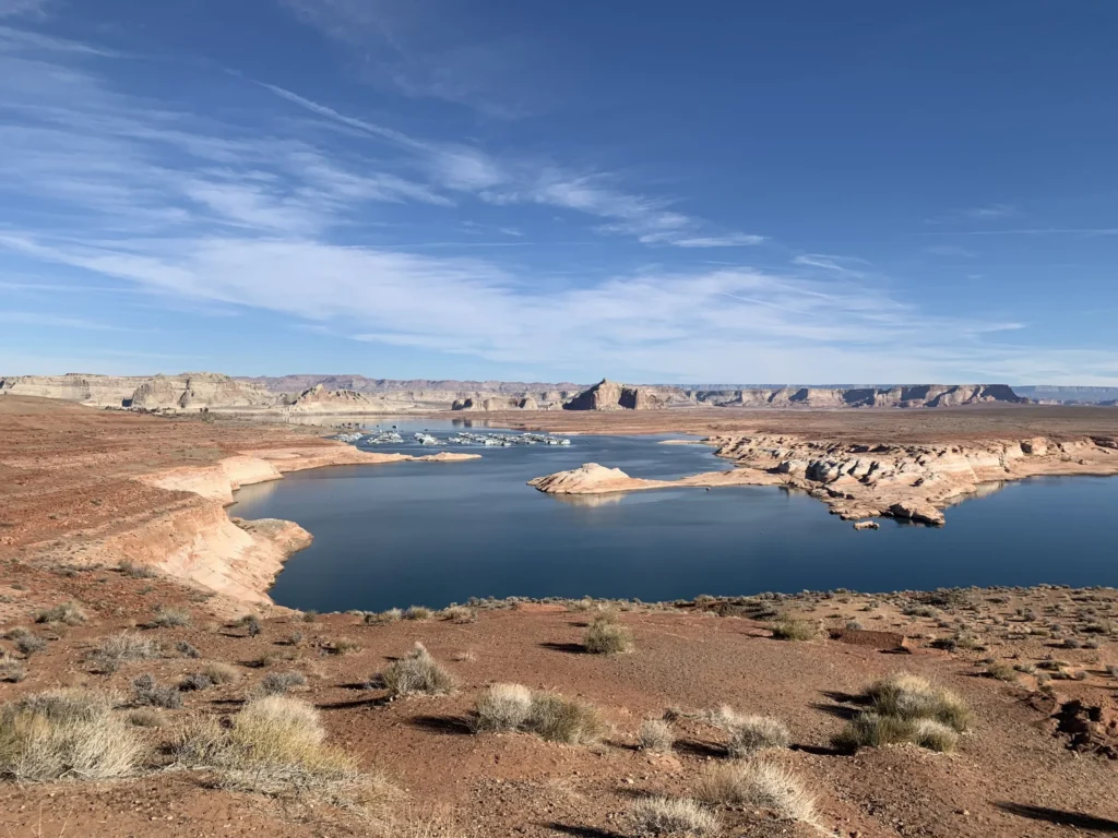
Lake Powell, on the Colorado River, is seen from the air in 2019. The Upper Basin states are planning how to potentially fill a dedicated pool in the nation’s second largest reservoir. Credit: EcoFlight
This story was originally published by Aspen Journalism on March 19, 2026.
With a Lake Powell conservation pool nearly guaranteed for the future of Colorado River management, the four Upper Basin states are exploring and refining the ways they could fill it.
Conservation by those states (Colorado, New Mexico, Utah and Wyoming) could be one of the keys to reaching a deal among the seven states that share the Colorado River and an important part of the framework for managing the drought-stricken river after this year. The water saved by the Upper Basin states could be stored in Lake Powell as a means of maintaining higher water levels and as an insurance policy against drastic cuts.
This type of pool isn’t yet being used in Lake Powell; it would have to be established by an agreement among the seven states. An agreement in the 2019 Drought Contingency Plan allowed for a 500,000 acre-foot Upper Basin storage pool in Lake Powell, but so far, the states have not utilized this and the agreement expires this year.
The Upper Basin and Lower Basin (California, Arizona and Nevada) have been at an impasse for more than two years about how the nation’s two largest reservoirs — Lake Powell and Lake Mead — will be managed and shortages shared in the future. The situation has never been more dire: The current guidelines for river management expire at the end of the year, while record-low snowpack is expected to push reservoir levels below critical thresholds. The seven states have blown past two deadlines to come up with a plan, and the federal government is gearing up for emergency actions to manage reservoirs.
The crux of the disagreement between the two basins has been over who should take shortages in drought years. The Lower Basin has committed to 1.5 million acre-feet of reductions annually and wants cuts beyond that to be shared by the Upper Basin. The Upper Basin says its water users already take cuts in some years because streams run dry by midsummer and any contributions they make must be voluntary.
The main boat ramp at Wahweap Marina was unusable due to low water levels in Lake Powell in December 2021. The U.S. Bureau of Reclamation is projecting that the reservoir will fall below critical thresholds later this year. Credit: Heather Sackett/Aspen Journalism
Contribution not conservation
Some Upper Basin officials have made a slight shift in the way they now talk about a pool in Lake Powell. No longer referred to as a conservation pool, it is called a “contribution” pool, reflecting the different methods — not only conservation of agricultural water — of contributing water to a Lake Powell pool.
Traditionally, the Colorado River basin states have turned to programs that pay irrigators to voluntarily leave fields dry for a season or two as the primary way to cut water use. With agriculture representing the majority of water use in the Upper Basin, it’s often the low-hanging fruit when it comes to water savings.
But at least two Upper Basin states are turning to other methods to contribute water to a Lake Powell pool.
For example, New Mexico can contribute water from Navajo Reservoir that it leases from a tribe. In Colorado, the method is less straightforward, but officials say the state is prioritizing and expanding existing programs and projects that save water.
“When you talk about things like turf removal, water-loss prevention, watershed restoration, forest-health efforts that are happening on the ground, those are benefits not only to Colorado but to the entire system,” said Becky Mitchell, Colorado’s lead negotiator in talks among the seven states that share the Colorado River. “So we’re trying to figure out: How do we acknowledge all of that work?”
Raymond Langstaff, a rancher and president of the Bookcliff Conservation District, irrigates a parcel north of Rifle. The state of Colorado explored the feasibility of a demand management program that would pay irrigators to cut back, but did not implement one. Credit: Heather Sackett/Aspen Journalism
Utah touts pragmatic approach
Over its run in 2023 and 2024, the federally funded System Conservation Pilot Program doled out $45 million to Upper Basin irrigators to cut their use by about 100,000 acre-feet. Utah water users received about $15 million of that in exchange for temporarily forgoing about 37,000 acre-feet of Colorado River water. The state put lessons learned with SCPP to use and is now in the second year of its own demand management pilot program, funded by $5 million from the state legislature and run by the Colorado River Authority of Utah.
The pilot program lets water users temporarily participate in a conservation program, and pays them $390 an acre-foot of water to do it. In 2025, Utah sent about 8,000 acre-feet downstream to Lake Powell under this pilot program, according to Marc Stilson, deputy director and principal engineer of the authority. There are a couple industrial water users and one municipal water user among the participants, but the majority are agricultural, he said.
“The pilot program is trying to iron out all these issues so that if we end up with some type of post-2026 commitment to do these types of voluntary conservation programs, we’re ready to do it,” Stilson said. “There is a very pragmatic approach in Utah looking at the big picture, and I think generally there is a sense that we have to adapt to changing conditions.”
Whether the program will continue after this year is unclear and could depend on whether the states reach a deal.
“We were anticipating that we’d have an agreement and that these types of programs would be part of that agreement,” Stilson said. “I think we just have to take a wait-and-see approach.”
Wyoming is also looking to traditional programs: State lawmakers are establishing a voluntary water conservation program. Wyoming state engineer and lead negotiator Brandon Gebhart did not respond to phone calls, emails or a list of questions from Aspen Journalism.
Boater on the San Juan River in May 2023. New Mexico officials say they can contribute water to a pool in Lake Powell through releasing water they lease in Navajo Reservoir. Credit: Heather Sackett/Aspen Journalism
New Mexico seeks ‘more diverse’ ways to contribute water
The state of New Mexico plans to contribute to a Powell pool mostly through 20,000 acre-feet of Navajo Reservoir water, which it leases from the Jicarilla Apache Nation and can be released down the San Juan River. Along the way to Lake Powell, it boosts flows for endangered fish. Officials say because they can control when they release the water, it can be tracked with certainty to the reservoir.
“We all need to focus on more diverse ways of contributions, not just the classic conserved consumptive use,” said Ali Effati, Colorado River basin bureau chief for the New Mexico Interstate Stream Commission.
Water managers say that automatically turning to agricultural water isn’t always reliable because as climate change continues to rob rivers of flows, even if senior water users want to participate in these types of conservation programs, they may not have any water to spare in dry years.
“That doesn’t mean that we have shied away from those sorts of activities, but to the extent that we can do our part without having to ask our agricultural community to cut water where they already take significant cuts almost annually, that’s just a preferable perspective,” said Estevan Lopez, lead negotiator for New Mexico.
Lopez said the likelihood of seeing a future Upper Basin contribution pool in Lake Powell is nearly 100% and that New Mexico will be ready, willing and able to contribute its share of water when the time comes.
“We have our percentage easily covered, plus a significant amount more,” he said.
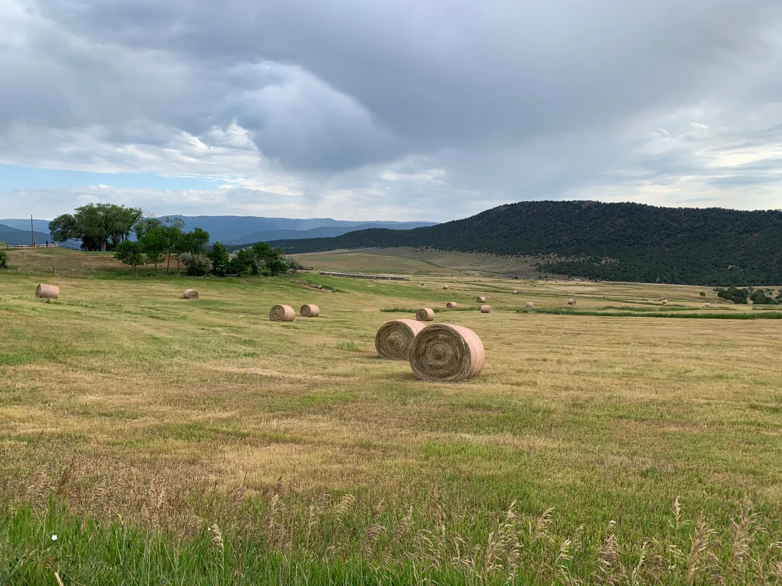
These hay bales stand ready to be collected on a ranch outside of Carbondale in July 2024. Upper Basin states have traditionally looked to agricultural to conserve water, but some are now turning to other ways to contribute water. Credit: Heather Sackett/Aspen Journalism
Colorado points to programs already in place
Colorado water users participated in both years of SCPP, but the state has been reluctant to take the leap into setting up its own program, despite being an early leader of the conservation conversation among the Upper Basin states.
In 2019, Colorado convened nine workgroups to explore the feasibility of a demand management program. The process included Colorado River water users from across the state and in multiple water-use sectors, who looked at how to set up a temporary, voluntary, compensated state program. But in 2022, the state water board shelved the studies without implementing a program, in favor of focusing on drought-resiliency initiatives.
Mitchell said the demand management feasibility investigation was an incredibly valuable exercise, but that there are still a number of open questions. Inaction on a demand management program doesn’t mean inaction on conservation overall, she said.
“The CWCB board voted to pause that investigation until there was clarity about whether any such program would be achievable, worthwhile and advisable and until there’s evidence that a demand management-esque program would benefit Colorado,” Mitchell said.
In 2023, Colorado lawmakers created a task force to again examine how the state could implement demand reduction and conservation programs. Water managers punted the issue again, failing to make recommendations to lawmakers on this topic, with some members saying conservation programs were “premature.”
The state still does not seem to have the policies in place to implement a large-scale, traditional conservation program in the near future. Mitchell said Colorado’s plan to contribute water to a Lake Powell pool is through the programs and projects already in place, many of which are funded through the state’s Water Plan grants.
At its March meeting, the CWCB approved more than $13 million for 38 projects across the state, according to a press release. They include things like urban turf replacement, creek and wetland restoration, outdoor water budgeting and wildfire ready action plans.
“Our strategy is to continue on with the programs that are already in existence, continue to fund conservation efforts that benefit all Coloradans as well as the entire system, continue to live within the means of the river and adapt our uses to align with available supply,” Mitchell said. “Because of all those programs already set up, we believe we have the majority of the structure in place.”
But Mitchell would not put a number on the amount of water that Colorado could contribute.
“We want to be a part of the solution when and how we are able to, but no, I’m not going to say we can do 100,000 acre-feet in a year like this,” she said.
Colorado River watchers may soon get some clarity around exactly how — and how much — Upper Basin states plan to contribute to a Lake Powell pool. On March 24, the Upper Colorado River Commission plans to consider projects to include in a “provisional accounting” memorandum of understanding (MOU) with the U.S. Bureau of Reclamation, according to UCRC Director Chuck Cullom.
Some Upper Basin projects that are not traditional agricultural conservation programs may be counted under the MOU, allowing the states to “get credit” for the water they save through unconventional means. Cullom said the UCRC and Bureau of Reclamation will also soon have an accounting report of water-saving activities undertaken in 2025.
Mitchell said Colorado is still committed to a seven-state consensus agreement and wants to avoid litigation. But acknowledgement of what the Upper Basin is already doing to cut back on water use will be important.
“The MOU is one component where we would like to see some sort of real acknowledgement of what is occurring in terms of the way that we live within the means of the river and what our strict administration is doing,” Mitchell said. “As long as we are not acknowledged in what’s happening on the ground, I think we’re going to have struggles.”
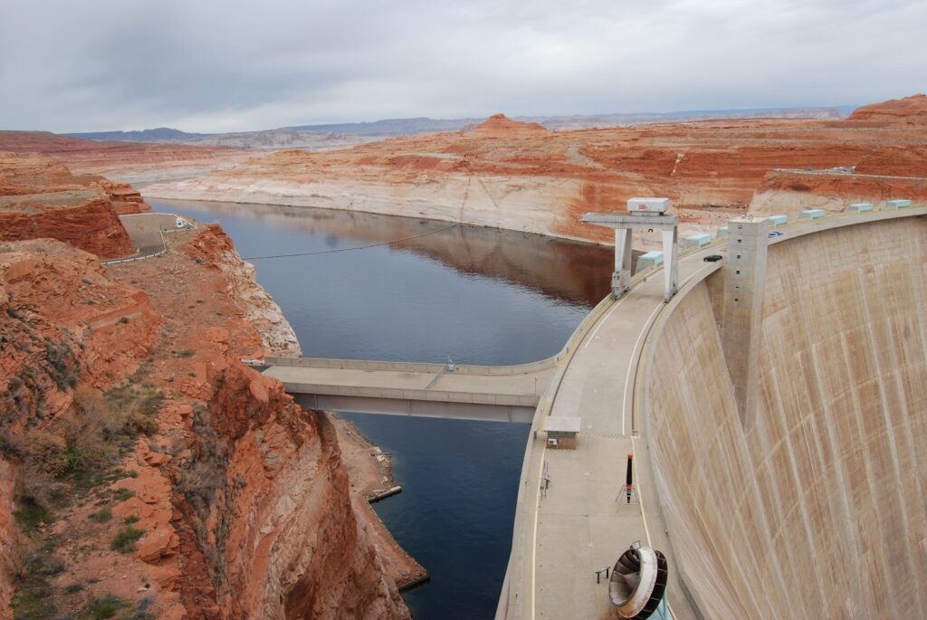
Lake Powell near Glen Canyon Dam in Page, Ariz. on Tuesday, May 20, 2025. (Trent Nelson / The Salt Lake Tribune)
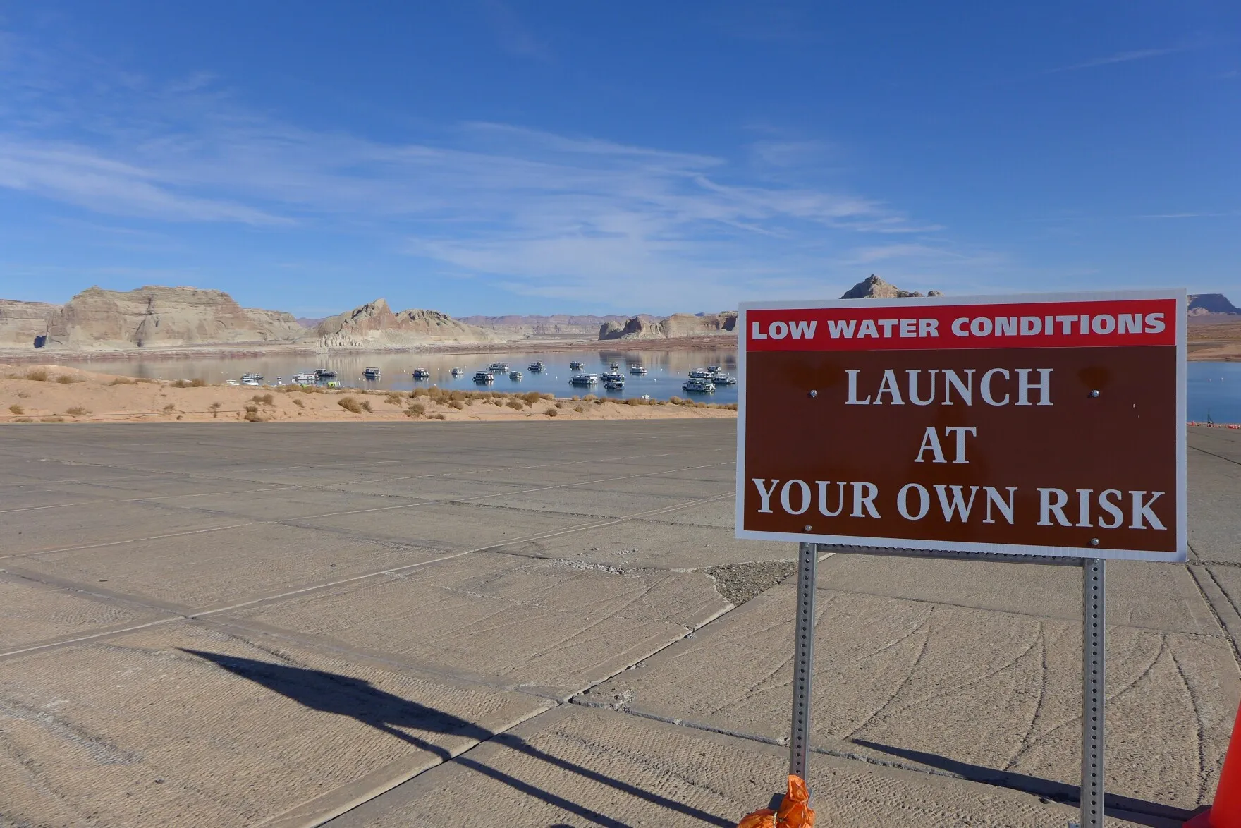
A cream-colored band lines the orange sandstone walls that rise above the blue-green waters of Lake Powell. The so-called “bathtub rings,” these chalky layers remind boaters zooming across the popular reservoir how far the lake has fallen.
After two decades of drought and an exceptionally warm winter, those rings will likely soon span even wider as Powell continues to drop towards a record low.
“Right now the hydrology that we have in front of us puts us in a very, very precarious situation,” said Gene Shawcroft, Utah’s Colorado River negotiator.
Utah just wrapped up its warmest winter on record. Salt Lake City broke its previous maximum average winter temperature by 2 degrees Fahrenheit — a significant increase, according to the Colorado Basin River Forecast Center. While the state received similar precipitation compared to last year, much of that fell as rain, leading to the worst snowpack since 1981 in parts of the state. Now, the water supply outlook is “well below normal,” according to the center.
The Bureau of Reclamation’s latest most probable forecast for Lake Powell shows it sinking below “power pool” — 3,490 feet — by December. At that level, water can’t make it through the turbines at Glen Canyon Dam that generate hydropower and keep the lights on across Utah and six other states.
Powell could hit that dangerous low even sooner, though. The bureau’s most recent forecast was based on the Colorado Basin River Forecast Center’s February report. Since then, the center’s projection for water flows into Powell has dropped by 100,000 acre-feet.
The bureau’s most probable forecast can also be optimistic. The agency’s minimum probable forecast, which shows a dry scenario that would statistically happen only 10% of the time, sometimes aligns more with reality. Last year, the April 2025 minimum probable study forecasted Lake Powell to hit 3,535 feet in elevation by the end of February 2026. The lake currently sits at 3,530 feet.
The bathtub ring is visible at Lake Powell near Ticaboo, Utah on Tuesday, Oct. 17, 2023.(Bethany Baker / The Salt Lake Tribune)
The bureau’s latest minimum probable forecast shows the lake dropping below 3,490 by the end of August.
“It’s safe for us to assume that, unless Mother Nature is uncharacteristically generous, that Lake Powell elevations are going to fluctuate at elevations that we’re not comfortable with,” Wayne Pullan, Upper Colorado regional director for the bureau, said at a Glen Canyon Dam meeting last week.
How the feds could boost Powell
To prop up Powell, the bureau will likely rely on another popular Utah reservoir: Flaming Gorge.
The reservoir that straddles the border of Utah and Wyoming has the best water outlook in the basin, at 64% of normal, according to the forecast center. The Upper Green River, which flows into Flaming Gorge, is the “lone bright spot” for snow water equivalent — the amount of water snow holds. Colder snow holds more water.
Under a 2019 plan, the bureau may form an agreement with Utah and the other states in the Upper Colorado River Basin — Colorado, New Mexico and Wyoming — to release water from Flaming Gorge and a few other reservoirs, such as Blue Mesa in Colorado, to maintain hydropower at Glen Canyon Dam.
That’s what happened the last time forecasts showed Powell dropping to a dangerous low level in 2022. A record wet winter followed that dry year, though, boosting the reservoirs.
That’s not something states can depend on every year in the future.
“Flaming Gorge is a finite resource,” Amy Haas, director of the Colorado River Authority of Utah, told The Tribune. “You may get two or three or four major releases out of Flaming Gorge before you’ve brought that reservoir down to the mud, so to speak.”
“It is not going to save the system,” she added.
The Green River flows through Red Canyon and Flaming Gorge on Tuesday, June 20, 2023. (Trent Nelson / The Salt Lake Tribune)
In the short term, it may be Powell’s only hope, though.
Utah and the three other states in the Upper Colorado River Basin — Colorado, New Mexico and Wyoming — sent a letter to the bureau two weeks ago inviting them to form a plan for releases from Flaming Gorge and other upper reservoirs, Shawcroft said.
Releases would likely start on May 1 and go until April 30 of next year, Shawcroft added. The total water released could be around 500,000 acre-feet.
The bureau is also considering reducing how much it lets out of Powell to flow downstream to Lake Mead and ultimately Arizona, California and Nevada. The bureau has already held back nearly 600,000 acre-feet of water in Powell that it would normally release over the winter months.
Originally it planned to release that water this summer. That may not happen, though, depending on what adjustments the bureau ultimately has to make to prop up Powell, Pullan said during a meeting of the Colorado River Authority of Utah earlier this year.
“This summer might be a glimpse into what our future world is going to be, and that’s going to be really limited water use,” Jack Schmidt, director of the Center for Colorado River Studies at Utah State University, said.
“So many things are compromised now,” he added. “The only silver lining is that crises often force real innovation, and maybe that’s the only outcome that we get out of this.”
This article is published through the Colorado River Collaborative, a solutions journalism initiative supported by the Janet Quinney Lawson Institute for Land, Water, and Air at Utah State University. See all of our stories about how Utahns are impacted by the Colorado River at greatsaltlakenews.org/coloradoriver.
The Roaring Fork River during spring runoff in 2023. An Aspen activist is hoping elected officials will pass a Rights of Nature resolution, giving rights to the river. Credit: Curtis Wackerle/Aspen Journalism
This story was originally published by Aspen Journalism on March 6, 2026.
An Aspen activist is hoping to gain support for a paradigm shift in the way people view their local waterway by granting rights to the Roaring Fork River.
Environmental psychologist, author and Aspen Times columnist Lindsay Branham is asking local elected officials to consider a resolution protecting the Roaring Fork and its tributaries by recognizing that nature has rights and that it’s the government’s responsibility to care for them.
“When I came across the rights of nature movement, it just really fascinated me because it invites people to really change the way they see nature altogether and removes the resource/object/othering language and framework, and invites this personhood,” Branham said.
The Rights of Nature is a small but growing movement that seeks to evolve the legal system’s relationship with nature from one that views rivers as a resource and property for human use, to recognizing that natural entities have intrinsic value and an inherent right to exist. It pushes back against the common notion that the “working rivers” of the American West simply convey water for human purposes.
“If you’re an innovator and a dreamer and you love nature, this movement for rights of rivers is right up your alley,” said Grant Wilson, executive director of the Durango-based Earth Law Center, a nonprofit that works to give nature a voice in the legal system.
Branham first presented the idea to Aspen City Council during public comment at a meeting in late 2025, but she was referred to the Pitkin County Healthy Rivers board. County staff have met with Branham and said they are looking closely at the issue. The consideration of a draft resolution by the Healthy Rivers board would be the first step in the process, though it’s unclear when such a resolution might be brought forward.
“We certainly recognize the importance of considering impacts of any actions on the river, but to a large extent we are already doing a lot of that through our land use code and through the Healthy Rivers and Streams board,” said Anne Marie McPhee, deputy Pitkin County attorney. “We’ve asked Lindsay for more information.”
A handful of Colorado communities have passed resolutions that give rights to local waterways: Grand Lake to its namesake body of water, Ridgway to the Uncompahgre River and most recently, Durango to the Animas River.
Indigenous communities have been some of the first to take up this cause. In November, the Colorado River Indian Tribes granted personhood to the Colorado River for the roughly 100 miles it flows through tribal land on the border between California and Arizona near the town of Parker, recognizing the river as a living being and the sacred obligation to protect it.
Once the rights of a river are codified in a resolution, local governments have a duty to consider them through policymaking and land use planning. Officials could also appoint a guardian to represent and speak on behalf of the river, and produce an annual report on the status of river health. The specifics are tailored to each community, and the resolutions are usually non-binding and largely symbolic.
Rights of Nature resolutions are not intended to spark litigation or meddle with water rights, Wilson said.
“What I’ve been advocating for is a softer, more cultural movement toward the rights of nature that’s not litigious,” Wilson said. “We’re not trying to get in the courts and cancel permits . … This movement is really a way to hold a mirror up to community values and how we treat nature.”
Ridgway Reservoir is formed by a dam on the Uncompahgre River. A resolution passed in 2021 by the Ridgway Town Council that gives rights to the river remains untested. Credit: Heather Sackett/Aspen Journalism
Ridgway resolution remains untested
In 2021, the town of Ridgway passed a resolution granting the Uncompahgre River, which flows through town, and its tributaries five inalienable rights: the right to maintain natural flow in sufficient quantity for ecosystem health; the right to support essential ecosystem functions; the right to feed and be fed by sustainable precipitation, glaciers and aquifers; the right to maintain native biodiversity; and the right to restoration and preservation of ecosystem health.
The resolution says the town has the responsibility to implement and enforce policies that support these rights, and oppose or address through mitigation activities that would violate these rights. Mayor John Clark said with miles of riverfront within town boundaries, protecting the waterway from encroaching development is important. But so far, the resolution remains untested, he said.
“Since we adopted the resolution, there’s been no need for any enforcement,” Clark said. “There have been no development proposals that would have triggered any action based on the resolution.”
Over four years after the resolution passed, the town still has not appointed a guardian of the river, although the local nonprofit Uncompahgre Watershed Partnership provides an annual report about the state of the waterway, Clark said. He said the resolution is a formal recognition that the Uncompahgre River is important to Ridgway residents’ quality of life and that the town council should consider the natural environment in decision-making.
“We did get a few people speaking up and saying, ‘what is the point of this if it doesn’t have more teeth to it?’” Clark said. “And our response was: ‘It’s a start. You’ve got to start somewhere.’”
While the Rights of Nature movement seems to be establishing a foothold globally – the Rights of Nature was enshrined in Ecuador’s constitution in 2008 – it has suffered setbacks in Colorado. After granting rights to Boulder Creek and appointing guardians to advocate for its interests, the town of Nederland repealed the resolution so it could support building its own dam on Middle Boulder Creek.
Gary Wockner, director of environmental group Save the World’s Rivers, was involved in this contentious back and forth, supporting the Rights of Nature resolution and then entering the water court case to oppose Nederland’s dam plans. But Wockner said the movement is less about water law and more a campaign of transforming hearts and minds.
“We’re moving toward a new paradigm in river protection,” Wockner said. “These resolutions are a concept that make intuitive, logical and passionate sense for people to start talking about how important the river is to their community and should have a right to exist.”
Branham is hoping Aspen can become the fourth Colorado town to grant personhood to its local waterway.
“Aspen and Pitkin County could really be known for setting a precedent and a standard for shifting an extractive relationship to natural ecosystems,” Branham said. “They already have in so many ways and this is another step. What if we could set that example?”
The water that comes down from the high country that will eventually funnel into the Arkansas Valley Conduit will be stored at Pueblo Reservoir, pictured here on Jan. 31, 2026. (Annie MacKeigan/The Water Desk)
For the last two years, Robin Daigle has had to boil her tap water before pouring it in ice cube trays.
She boils tap water if she needs it to cook. When her children are thirsty, Daigle drives 30 minutes to Walmart to pick up bottled water.
“We are afraid to drink the water,” said Daigle, who moved to North La Junta, Colo. two years ago and has not had drinkable tap water since.
She is far from alone. Residents of southeastern Colorado regularly take trips to the store to buy potable water. They wash their clothes and bathe in the contaminated water that flows from their faucets.
“I worry that over time it could cause health problems,” Daigle said. “Having safe drinking water is vital for humans to be able to thrive.”
In southeastern Colorado, tap water can run orange out of the faucet, smell of bleach and corrode the appliances it touches. Tap water can be laden with some carcinogenic contaminants, like naturally-occurring selenium and radium. Many of the valley’s shallow groundwater wells produce water high in iron, manganese and other heavy metals, which can be hazardous to human health. Sourcing of the contaminants found in the lower Arkansas Valley may include erosion of natural deposits and discharge from petroleum refineries or mines, according to EPA drinking water regulations.
The experiences of Daigle, her neighbors, and surrounding communities caught new attention following a presidential veto in late December 2025 that denied measures to refinance the cost to construct the Arkansas Valley Conduit, a new source of drinking water. Many residents in southeastern Colorado still seek out potable water; some drive to the nearest grocer to buy individual bottles, gallon jugs, or even five-gallon jugs of drinking water. Others rely on reverse osmosis, or R.O., filters.
In many Arkansas Valley communities, the water is unsafe to drink, but residents are also concerned about the costs associated with the proposed solution: the 130 miles of pipeline the conduit project plans to build.
The pipeline project intends to serve potable drinking water to around 50,000 people in 39 communities and towns in rural southeastern Colorado. In conjunction with the federal Bureau of Reclamation, the Southeastern Colorado Water Conservancy District is constructing the pipeline and delivery lines aiming to serve the lower Arkansas Valley with potable water.
Construction began in 2023. Because of the scale and high cost, the project is taking a phased approach. As of Feb. 23, 2026, 12 out of 130 miles of trunk line have been constructed, and two out of 39 delivery lines have been constructed, according to Chris Woodka, senior policy issues manager of the Southeastern Colorado Water Conservancy District.
President Donald Trump vetoed H.R. 131 in Dec. 2025. The act had passed through the House and Senate unanimously with bipartisan support before it was vetoed. The legislation aimed to refinance the existing terms of the project by lowering interest rates from 3% to 1.5%, and extending the repayment period of the project from 50 years to 100, then amended to 75 years.
The veto did not add or remove any funding for the project itself, according to Woodka. “We didn’t stop any construction,” Woodka said. The project, he said, was not stalled at all.
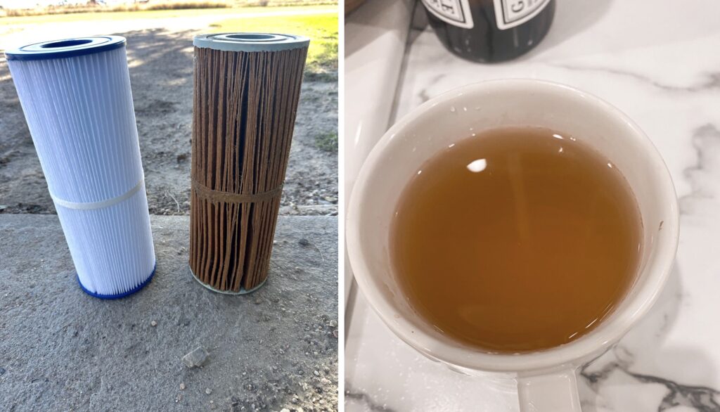
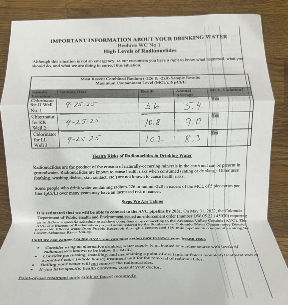
Lindsey and Jarett Hart are customers of Beehive Water Association, a small, rural cooperative water provider, near the town of Cheraw. They receive quarterly updates from the water company about the quality of their drinking water, which flows out of their tap discolored. Beehive Water Association estimates that they will be able to connect to the Arkansas Valley Conduit by 2031.
When the couple took their hot tub filter out after three months of use, their old filter was browned and weathered (left). On a tap without an iron filter, the Harts’ water comes out in orange and brown hues (right). (Photos courtesy of Lindsey Hart)
“I am not happy about [waiting] five years, but I would live with it if that meant eventually we could have access to that cleaner, healthier, safer water,” said Lindsey Hart, who is worried that estimate may not be accurate at all. She and her husband feel that updates are not widely available to the public, so they are left guessing. “I certainly wish we could have access to it a lot sooner.”
Her frustration does not stop at contaminated drinking water. “We can’t even cook with our water. We can’t boil pasta or cook rice or anything like that safely,” Hart said. “Our water down here is awful.”
In their home, plants die and appliances corrode, all because of contaminated water. The couple does not give the water to their pets either. “When I smell bleach when we turn on our tap or our shower, it’s very frustrating,” Hart said. “It makes me just really irritated and angry.”
Corrosion of household plumbing systems pose their own set of health risks, including lead poisoning.
Beehive Water Association sends quarterly updates about the quality of drinking water to their customers. (Photo courtesy of Lindsey Hart)
The Arkansas Valley Conduit project has been in the works in some form since the Kennedy Administration. In the 1960s, it was part of the Fryingpan-Arkansas Project Act. Portions of that large-scale transmountain diversion project were built out, but not the Arkansas Valley Conduit. The conduit project was halted in 1978 due to funding scarcity.
By 2000, the conduit was revived. Water quality testing found high levels of radioactive materials in well water, prompting a grassroots group to form in Otero County, advocating for improvement in the quality of their drinking water.
Riddled with radionuclides and high levels of salinity and selenium, the water in some cases exceeded the maximum contaminant levels (MCLs) set by the EPA. Each of these contaminants pose various health risks for humans when ingested.
An environmental impact assessment administered by the Bureau of Reclamation found that the project was the best option to reduce community exposure to the contaminated water. “A lot of people down there say, ‘we don’t drink the tap,’” Woodka said. “That’s the situation that creates the need for the Arkansas Valley Conduit.”
Residents in Southeastern Colorado recreate on the Arkansas River, just east of the Pueblo Reservoir on Jan. 31, 2026. // (Annie MacKeigan/The Water Desk)
Residents of southeastern Colorado are already weary of the potential rising costs they will incur in the face of the project.
“I cannot fathom anyone would want to smell bleach in their water, or go to turn on the faucet outside and it’d be absolutely burned from rust,” said Hart. “I think the issue is nobody has told these communities or people that are receiving this, what is it actually going to cost us on our water bill?”
Federal legislation passed in 2009 allowed for 35% of the cost burden to be covered locally, the remaining 65% federally. This share was intended to make the project more affordable for the people of the Lower Arkansas Valley.
However, in 2024, the construction bill for the project went up due to increases in costs of materials and unanticipated conditions builders ran into on the ground. In 2020, the estimated cost of the project was around $600 million. In 2024, that estimate jumped to $1.3 billion, according to Woodka. Despite the price hike, the project still has support in Colorado. According to Woodka, more than $4 million in grants and loans from the state have gone to construction.
Trump’s veto also spurred rare bipartisan condemnation among the state’s congressional delegation. U.S. Reps. Lauren Bobert, Jeff Hurd and Joe Neguse have each expressed outrage at the veto decision, and Congress’ refusal to override it.
But not every Arkansas Valley resident is anxious for the new water supply. James Budnick, a plumber and eight-year resident of Rocky Ford, worries how costs will affect the community. He is in regular attendance at meetings related to water rights in Rocky Ford and Otero County. “I ask them the same question, how is this going to be regulated and who will be regulating it?” Budnick said.
His main concern is that the promise of better water quality will bring development to Rocky Ford and costs will fall on taxpayers rather than developers. “I love Rocky Ford because it’s a small town, but I see that water coming as a threat to the lifestyle,” he said. “The only reason that the valley is the way it is, is because of the water laws out here.”
Budnick is a member of Newdale-Grand Valley Water Company. The company has a limited number of taps, or a limit on the number of homes they can supply with water. Budnick is particularly worried that the conduit would change water regulations in Rocky Ford with higher costs, less availability.
A three-way contract between Pueblo Water, the Bureau of Reclamation and the Southeastern Colorado Water Conservancy District was finalized in March of 2022. (Annie MacKeigan/The Water Desk)
“I understand people wanting to save money, as water is extremely expensive,” said Bobby Scott, who recently relocated to the town of Fowler, “but not at the expense of their health. Coming from Texas, this water difference is noticeable.”
The difference was so noticeable that in the first few weeks of Scott and his wife living in Fowler, they started to feel sick from the water. “I want to find out what we’re drinking,” Scott said.
The Arkansas Valley Conduit water itself comes from the Fryingpan River on Colorado’s Western Slope. It travels in a tunnel through the Continental Divide, where it deposits into Turquoise Lake just outside Leadville. The water then flows down into Twin Lakes and down the Arkansas River. It then collects in Pueblo Reservoir, where the water will be treated. Then, the 30-inch trunk line will deliver water to Avondale through Lamar via 39 delivery lines down the lower Arkansas Valley.
Only two communities in Pueblo County are participants of the Arkansas Valley Conduit. Above is a branch of the Arkansas River in Avondale, one of the participating communities, on Jan. 31, 2026. (Annie MacKeigan/The Water Desk)
Of the 39 participating communities on the Arkansas Valley Conduit, the majority reside in Otero County. Otero County Commissioners came together to ask for the president to rescind his recent veto of H.R. 131. “Providing clean drinking water is our priority as County Commissioners,” they said in a statement made in early February. “This water project is vital to our communities.”
Woodka estimates that the more than $400 million of federal funds and more than $4 million from the state will be enough to build delivery lines through Rocky Ford. “Nothing like it has been done before, 39 water systems into one pipeline,” said Woodka, who remains optimistic about the project’s future.
“It’s at greater momentum than it has ever had right now.”
This story is produced and distributed by The Water Desk at the University of Colorado’s Center for Environmental Journalism.
Water levels were low at Lake Powell’s Wahweep Marina in November 2021. Recent worst-case projections from the U.S. Bureau of Reclamation show the reservoir declining below power pool by July. Credit: Heather Sackett/Aspen Journalism
This story was originally published by Aspen Journalism on February 20, 2026.
The Colorado River crisis is no longer part of some hypothetical future — it’s here.
Fueled by one of the worst snowpacks on record, the “most probable” February projection from the U.S. Bureau of Reclamation estimates 5 million acre-feet flowing into Lake Powell this year, which is 52% of average. A more grim estimate puts that number at just 3.5 million acre-feet, or 37% of average.
Forecasts show the nation’s second-largest reservoir could fall below the minimum level needed to make hydropower at Glen Canyon Dam as soon as July under the worst-case scenario, or by December under the “most probable” forecast. Reservoir levels are projected to fall to their lowest elevation on record in March 2027, threatening the water supply for millions in the Southwest.
But the increasingly dire projections, this winter’s historically bad snowpack and the growing gap between supply and demand haven’t yet pushed the seven states that share the river to come to an agreement on its future management.
Last week, state negotiators blew past a second federally set deadline to find a consensus plan on how to share shortages and manage Lake Powell and Lake Mead after the current guidelines expire at the end of the year. They have been stuck at an impasse for two years.
The need for a new management paradigm that adapts to a shrinking water supply has never been more urgent. So why isn’t the crisis forcing a deal?
“We’re at a moment where we really need something different that responds to our current hydrology, our current demands, and we’re not seeing a development of that kind,” said Elizabeth Koebele, a professor of political science and associate director of the graduate program of hydrologic sciences at the University of Nevada, Reno. “You’d think that all of these signals would be pointing to the fact that we really need to do something different, but we’re not.”
Anne Castle, a former federal representative to the Upper Colorado River Commission and a Colorado River expert, co-authored a paper in 2021 that said successful negotiations of new Colorado River agreements tend to be triggered by very dry conditions, and that federal directives and deadlines also play an important role. But the current stalemate amid worsening drought throws those findings into question.
“Our premise was that a crisis in terms of water supply and reservoir levels and snowpack and expected runoff can prompt creative compromise,” Castle said. “But we have all those underlying conditions, and we don’t have a compromise.”
The scale of the problem could be part of what’s making consensus difficult between the Upper Basin (Colorado, New Mexico, Utah and Wyoming) and the Lower Basin (California, Arizona and Nevada). As a junior water user on the river, the Central Arizona Project, which supplies the metro Phoenix and Tucson areas, could face the deepest cuts.
“I think if this had been a 2 million-acre-foot problem, the states probably could have solved it, but it’s potentially a 4 million-acre-foot problem,” said Kathryn Sorensen, a researcher and professor at Arizona State University’s Kyl Center for Water Policy. “There’s so little water to go around that positions have become hardened as a result. We’re not just talking about inconvenient cuts; we’re talking about severe pain to economies at this point.”
Federal involvement
Some of the normal levers that have been pulled to force action in the past — such as directives and deadlines from the federal government — don’t seem to be effective in the current situation. There have been no apparent consequences for the states missing both the Feb. 14 deadline and an initial Nov. 11 deadline set by the feds for the states to present the outline of an agreement.
The seven state negotiators and their governors were summoned to Washington, D.C., the last week of January for a meeting with Department of Interior officials. That, too, failed to result in a deal.
In a Feb. 14 news release, Interior Secretary Doug Burgum thanked the governors for their engagement and said a fair compromise with shared responsibility remains within reach.
Koebele said when the states were hashing out the 2007 guidelines, which currently govern the river and are just months from expiring, the threat of federal action was part of what spurred the states to come up with a plan.
“There’s a little bit less of this idea of a single or central federal leader in the negotiation process,” Koebele said. “And they’re also still saying, ‘Hey, states, please come up with your own option too.’ I’m not really sure how credible threats are from the federal government when we’re in this sort of context.”
Reclamation has presented five options for managing the river, but although the federal government owns and operates the infrastructure such as dams and reservoirs, it doesn’t have the authority to implement all of the actions outlined in the options. The new, innovative and collaborative actions would need an agreement among the states.
Absent that, federal officials believe the only tools at their disposal, which allocate cuts based on prior appropriation and existing water law, could see Arizona take up to 77% of total shortages, yet they “may not provide adequate protection of critical infrastructure or the system and may be viable only in the short term given current reservoir conditions,” according the bureau.
The federal management options are part of a draft environmental impact statement, which is required as part of the National Environmental Policy Act review for new guidelines. This process is moving forward on a separate, parallel track to negotiations among the states. If the states agree on a plan, it could be plugged into the EIS and become the “preferred alternative.”
“We’re sort of at a key moment for those two processes coming together,” Koebele said. “But the EIS and the state negotiations are not really intersecting in a way that we have seen them intersect in the past or that we hoped they would.”
Federal officials are accepting comments on the draft EIS until March 2.
Lake Pleasant, seen in April 2025, is a storage bucket for Colorado River water and is part of the Central Arizona Project that delivers water to the Phoenix and Tucson areas. According to one river management option from the federal government, Arizona would take the majority of shortages in dry years. Credit: Heather Sackett/Aspen Journalism
Blame to go around
In a series of news releases on Feb. 13, Upper Basin and Lower Basin officials blamed each other for the continuing standoff.
“We’re being asked to solve a problem we didn’t create with water we don’t have,” Colorado’s representative, Becky Mitchell, said in a prepared statement. “The Upper Division’s approach is aligned with hydrologic reality, and we’re ready to move forward.”
The crux of the issue is who should take shortages in drought years. The Lower Basin has committed to 1.5 million acre-feet of reductions annually and wants cuts beyond that to be shared by the Upper Basin. The Upper Basin says their water users already take cuts in some years because streams run dry by midsummer and any contributions they make through conservation must be voluntary.
Water managers upstream of Lee’s Ferry would note that they were promised an equal amount of water as the Lower Basin was in the 1922 Colorado River Compact, although they use about 4 million acre-feet a year, while the Lower Basin — whose flows are backed up by releases from the country’s two largest reservoirs — regularly uses all of the annual 7.5 million acre-feet to which it’s entitled. The Lower Basin’s position points to its larger population and economic output, and that their water users, already subject to mandatory cutbacks, tend to be more aggressive in their conservation measures.
“It’s the fundamental disagreement that we’ve had for the past many years,” Castle said. “The Upper Basin doesn’t want to agree to any enforceable reductions in use. And that is something that the Lower Basin, and Arizona in particular, don’t feel like they can live with.”
The states appeared to be on the verge of a breakthrough last summer, when representatives from both basins indicated a willingness to consider a supply-driven approach, where reservoir releases are more directly tied to the natural flow of the river. But hashing out the details is complicated, and a plan that all parties can agree to has yet to emerge.
A new management plan would need to be in place by the start of the new water year on Oct. 1. And if the states can’t reach an agreement by then, the federal government will impose its own management rules, doling out cutbacks that could trigger lawsuits from the states but would not go far enough to prevent the system from crashing.
Even if the states come to an eleventh-hour agreement, federal action will be needed in the immediate future to protect levels at Lake Powell and the ability to produce hydropower. The dire projections showing Powell dropping below minimum power pool assume that the feds would release 7.48 million acre-feet from Powell this year, but under a short-term agreement that also expires at the end of the year, they could reduce releases down to as little as 6 million acre-feet. The Bureau of Reclamation is also holding back about 600,000 acre-feet in Lake Powell through April, which will be released later in the year.
The last time Lake Powell was projected to drop below system-critical thresholds after the 2021 spring runoff, Reclamation conducted emergency releases from upstream reservoirs. The chance that the bureau will again release additional water from those federally controlled reservoirs — Flaming Gorge, Blue Mesa and Navajo — to boost Powell in the coming months is “about 100%,” according to Colorado River expert and author Eric Kuhn.
“Just how much is going to be up in the air, but right now, it looks like they need a million to a million-and-a-half acre-feet based on the current projections,” Kuhn said.
John Fleck, an author, writer and University of New Mexico professor, was the co-author with Castle on the 2021 paper, titled “Green Light for Adaptive Policies on the Colorado River.” He said that in previous negotiations, state representatives not only had a sense of responsibility to protect water for their own communities, but were also looking out for the health of the entire interconnected basin.
“What we have seen in the last few years is a shift to a leadership that is made up of people who are solely looking out for the interests of their own community,” Fleck said.
Experts say the Colorado River needs a new and different management plan that responds to dwindling flows, rebuilds reservoir storage and creates a resilient system in the face of climate change. The current leadership is failing to provide that, Fleck said. The solution is a shift in mindset for water managers to start playing not for the Upper Basin or Lower Basin, but for Team Colorado River Basin, he said.
“There’s a moral question involving the obligations we have to one another in shared river basins,” Fleck said. “I would not be at all happy to win the litigation and see the Central Arizona Project shut down. I would see that as a failure even though my community’s water supply might be protected.”
Lees Ferry in Arizona marks the point on the Colorado River where the Upper and Lower basins split. The two entities have been deadlocked over how to divide the scarce resource. (Caroline Llanes/Rocky Mountain Community Radio)Rocky Mountain Community Radio’s Caroline Llanes reports
The Colorado River Basin is in crisis.
Climate change is reducing its flow and its biggest reservoirs are shrinking. The seven U.S. states that use the river are negotiating cutbacks to their water use. The Upper Basin states of Colorado, Utah, Wyoming, and New Mexico are deadlocked with the Lower Basin states of California, Arizona, and Nevada.
But the federal government has a big stake in the negotiations, too. It oversees and operates some of the most critical infrastructure on the river, including dams that create its biggest reservoirs. Dwindling water levels hurt its ability to generate and sell hydropower. Lower flows degrade the federally-managed national parks the river flows through. Diminishing supplies threaten the viability of the river’s core legal document, the Colorado River Compact.
With all of those layered interests, it’s led some to ask: Why aren’t federal officials applying more pressure to get a deal finalized?
This would not be the first time the federal government has tried to decrease water use on the Colorado River. A little over 20 years ago, California was using about 800,000 acre feet of water more than it was allotted. Federal officials stepped in, with the goal of reining in the river’s single biggest water user, the Imperial Irrigation District.
“If you’re going to solve a water shortage, you don’t go to the little guys, you go to the big guy,” said Tina Shields, one of the water managers at IID. Shields was at the district during QSA negotiations and currently oversees its compliance with the agreement.
Farms in Southern California’s Imperial Valley—an agricultural powerhouse that grows some of the nation’s winter produce—rely on the powerful district to deliver Colorado River water.
The All American Canal, the largest diversion on the Colorado River, passes through Winterhaven, CA on its way to the Imperial Valley. The Colorado River is seen flowing next to it. (Ted Wood/The Water Desk)
Recounting the fight over California’s overuse, Shields says the district was presented with a deal to reduce their take in 2002, with a deadline to sign it. IID’s board declined. Interior Secretary at the time, Gale Norton, threatened to cut off water deliveries to the district. The secretary is considered the “water master” among the river’s Lower Basin states.
“Essentially it was a coordinated federal and state attack on IID to get us to agree to the deal,” she said.
In 2003, IID agreed to a deal that drastically reduced its water use in exchange for payments from large municipal water providers in the state, which is now known as the Quantification Settlement Agreement. But the year between IID’s rejection of the initial deal and its signing was marked by resistance from the district, playing out in lawsuits and court battles—and lots of federal pressure.
“At the time, it was not good,” Shields said. “We had a gun to our head and our arm twisted behind our back. But through the 20 years since then, we’ve developed the relationships with the management and the staff of these other agencies.”
IID says that since 2003, it has conserved 9 million acre feet of water, and Shields said the QSA could be a model for other states looking to cooperate on conservation measures. But, she reflected, the QSA saga is in sharp contrast to the way the federal government is currently handling the Colorado River.
“Back then, when a deadline wasn’t met, there were consequences to it, right?”
Since then, the warming and drying trend in the Colorado River Basin has gotten much worse, necessitating cutbacks. The Upper and Lower Basins have not been able to agree on who will take those cuts, bypassing deadline after deadline set by Reclamation to come up with a deal. Another deadline looms: February 14, 2026 marks a deadline for the states to present the Bureau of Reclamation with a deal that outlines the conservation commitments between the basins.
All the while, climate change is threatening the viability of federal infrastructure – like Hoover Dam and Glen Canyon Dam, and their hydropower turbines.
Colorado River water is released from Lake Powell through the hydropower turbines at Glen Canyon Dam near Page, Arizona. (Caroline Llanes/Rocky Mountain Community Radio)
“Our hydrology is permanently bad,” said Elizabeth Koebele, an associate professor at the University of Nevada Reno, where she researches Colorado River governance.
“This isn’t something that we bounce back from anymore,” she said. “Even a really good water year doesn’t really do a lot for our storage reservoirs. And now, the most cutting-edge science says even the same amount of snowpack isn’t producing the same amount of runoff into our streams anymore because we have all these other processes going on related to aridification.”
Koebele said less water makes hard decisions even harder, and it backs the states into their respective corners, refusing to make concessions. Uncomfortable yet necessary basin-wide cuts have created a dynamic that has made Reclamation reluctant to play bad cop.
“It’s become really political, and so someone is going to be upset by any decision, which could lead the states to sue the Bureau of Reclamation and bring this to court,” she said. “And that could take a really long time to solve.”
Arizona, which is facing some of the most severe cutbacks, has been especially vocal about the feds getting more involved in negotiations—a stark departure from years past, when the states would have wanted to make these decisions themselves.
Arizona Governor Katie Hobbs, a Democrat, pushed Interior Secretary Doug Burgum to host all the Colorado River governors in Washington D.C. in late January.
“Having the secretary there to hear from us directly, like what we need to see a deal that’s fair — and I think especially with the secretary having been a governor and sort of being able to understand it from our perspectives — was really helpful,” she said.
She said she felt the governors left the meeting with an understanding of how they could be involved in the ongoing negotiations, and appreciated Burgum’s role as a facilitator and convenor for that conversation.
“I guess we’ll know when the negotiators get back in the room, if that actually had some impact there,” she said of the meeting. “But I think we all left the room feeling like we were at a better place… I don’t know that we’re at a place where we will have an agreement by the deadline, but I think we’ll be much closer to one than we would’ve been otherwise.”
The Colorado River flows through Glenwood Canyon, along the Hanging Lake rest stop. The headwaters of the river are facing historically low snowpack in 2026. (Caroline Llanes/Rocky Mountain Community Radio)
Though some water users are eager for stronger leadership on the river, they say it’s a risky move to invite more federal involvement.
Jim Lochhead, who used to be Colorado’s top river negotiator, said he worried that the river’s myriad problems would become even more political than they already were. He said the Trump administration is unpredictable, and has created a lot of uncertainty around other water issues in the West.
“We saw a veto of the Arkansas Valley pipeline by President Trump,” he said, referring to a project in Southeastern Colorado that would have delivered water to communities east of Pueblo. “We see money being withheld from the state of Colorado. So who knows what this administration might do?”
But there are also questions about what Reclamation can even do. In an environmental impact statement released last month, it outlined a few alternatives for how the agency could proceed, while emphasizing that it would prefer the states to come to an agreement themselves. Several of the alternatives include actions that the agency doesn’t currently have the legal authority to carry out, meaning it would need to go to Congress for additional powers, or renegotiate longstanding deals with states.
“It’s politics,” said Koebele. “It’s recognizing that the situation we’re in is so different that we’re even testing the limits of Reclamation’s authority.”
In the end it might not be the federal government’s hand forcing the states to make a deal, it could be pressure from Mother Nature. Record low snow totals this year in the river’s headwaters mean the hard decisions are coming sooner rather than later.
This story was produced in partnership withThe Water Desk at the University of Colorado Boulder Center for Environmental Journalism.
Copyright 2026 Rocky Mountain Community Radio. This story was shared via Rocky Mountain Community Radio, a network of public media stations in Colorado, Wyoming, Utah, and New Mexico, including Aspen Public Radio.
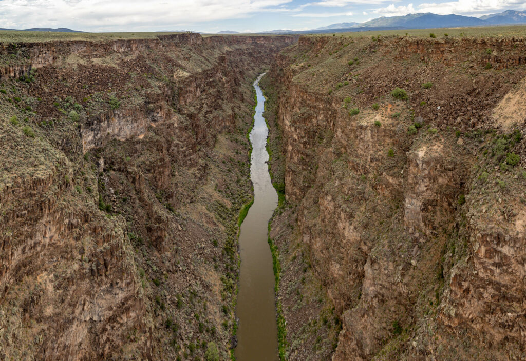
The Rio Grande Gorge near Taos, New Mexico, on June 24, 2024. (Mitch Tobin/The Water Desk)
The Water Desk is excited to announce the participants for our next Rio Grande journalist training and workshop, taking place in El Paso, Texas, in March 2026.
This training program will bring together journalists dedicated to enhancing coverage of water issues in the Rio Grande basin, fostering collaboration among news outlets and deepening understanding of critical challenges facing the region.
The Water Desk selected 15 journalists to participate in the training, reflecting diversity in geography, race, ethnicity, gender and medium.
Participants:
Brenda Bazán, Independent
Ana Bueno, Univision 45
Austin Corona, Independent
Bryce Dix, KUNM-FM
Caroline Gutman, Independent
Caroline Llanes, Rocky Mountain Community Radio
Sage Marshall,Independent
Verónica Martínez, Independent
Alaina Mencinger,The Santa Fe New Mexican
Diego Mendoza-Moyers, El Paso Matters
Carlos Morales, Independent
Amanda Pampuro, Courthouse News
Emily Payne, Independent
Martha Pskowski, Inside Climate News
Paul Ratje, Independent
The Rio Grande starts in the Rocky Mountains of Colorado and flows through New Mexico and Texas, forming much of the U.S.-Mexico border. The river has experienced extremely low flows amid warming temperatures and declining snowpack. Coverage of the communities and ecosystems dependent on the Rio Grande is essential to understanding what’s at stake as the gap between water supply and demand widens.
As part of The Water Desk’s training program, participants will learn from legal experts, water users and tribal members in the river’s borderlands, gaining insight into varying perspectives on how the Rio Grande shapes the region’s culture, politics and ecology.
The workshop will feature sessions on the complexities of water management, field trips to sites in and around El Paso, and opportunities to network with peers and regional water experts. The Thornburg Foundation, a Santa Fe-based family foundation, is providing the financial support to make this training possible, while the program is the sole responsibility of The Water Desk.
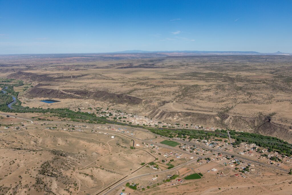
The Rio Grande near Albuquerque. The river increasingly runs dry for significant stretches. Though the EPA still requires permits for surface water discharges into it, “I’d be lying if I said this wasn’t a concern,” said Jonas Armstrong of the New Mexico Environment Department. (Mitch Tobin/The Water Desk with aerial support by LightHawk)
In 2004, Michael and Chantell Sackett purchased a plot of land near Priest Lake, Idaho, in the picturesque northern reaches of the state’s panhandle. On one side of their lot, a row of houses separated them from the lake; on the other, a 30-foot-wide road separated them from a wetland called the Kalispell Fen. To construct a home on their marshy land, they began to backfill it with soil and gravel. When the Environmental Protection Agency caught wind of this, regulators told the Sacketts that because their property was part of a wetland, they had violated the Clean Water Act. The agency threatened the couple with a fine of $40,000 per day if they did not restore the site.
Instead of complying, the Sacketts sued the government. The case lasted decades, culminating in a Supreme Court case. In 2023 the court decided in the Sacketts’ favor. Its ruling narrowed the legal definition of the “Waters of the United States” (WOTUS), which are the waterways that the federal Clean Water Act oversees.
The text of that law broadly defines the WOTUS as navigable waterways and their adjacent wetlands. Yet in recent years, what exactly “adjacent” means has been a matter of debate. In its 5–4 decision in 2023, the court determined that protected wetlands must have a “continuous surface connection” to be considered adjacent to waterways.
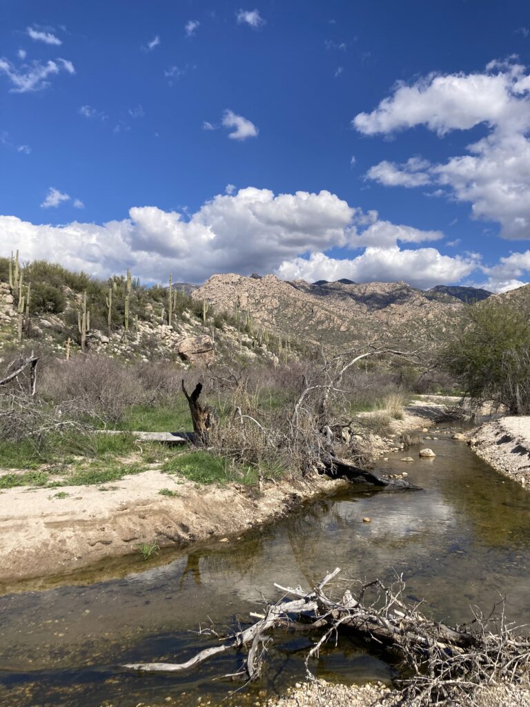
An ephemeral waterway in Southern Arizona with water flow. (Caroline Tracey/The Border Chronicle)
For environmental advocates, the Sackett decision, as it’s known, dealt a major blow to water protection, disregarding scientific evidence about how waterways flow and connect. The decision was nowhere more impactful than in the U.S.-Mexico borderlands. That’s because after the Court’s ruling, the EPA determined that intermittent and ephemeral waterways—those that don’t run year-round—were no longer protected by the Clean Water Act. In both Arizona and New Mexico, over 90 percent of all stream miles don’t run all year. A decision made with Idaho homeowners in mind meant that much of the Southwest risked losing clean water.
The Sackett decision came on the heels of several previous cases that limited the scope of the Clean Water Act—and that had a particularly harmful impact on the borderlands. “This has just been an onslaught across the arid Southwest by agencies and justices that don’t understand the hydrology,” said Rachel Conn of the New Mexico environmental organization Amigos Bravos in an interview with TheBorder Chronicle. Additionally, many of those intermittent (seasonal) and ephemeral (carrying water only after storms) waterways cross the U.S.-Mexico border, meaning that regulating discharge into them isn’t just a local issue but an international one.
As the federal government steps back, New Mexico is leading the way in filling the regulatory gap.
The Clean Water Act, first passed in 1972, regulates the dumping of waste into waterways considered to be WOTUS. For 30 years, the law remained in its original form. Yet in the past 20 years, it has seen four significant reinterpretations.
In 2003, the Supreme Court determined that the Army Corps of Engineers had overstepped the Clean Water Act in requiring a permit to dump dredge-and-fill material into an isolated body of water in Illinois that did not connect to any navigable waters.
In 2006, the protracted Rapanos v. United States case created new uncertainty about which wetlands were protected by the act. This led to an interpretation called the 2015 Clean Water Rule. According to Conn, it caused a loss of protections for New Mexico’s closed basins—those that drain inward rather than to the sea—which make up 20 percent of the state’s territory.
In 2020, under the first Trump administration, the Navigable Waters Protection Rule was implemented to roll back the Clean Water Act’s protection of wetlands. The 2023 Sackett decision cemented its restrictions on the Clean Water Act.
Though initially the Biden administration’s EPA was tasked with creating a rule to implement the Sackett ruling, on November 17, 2025, the Trump administration’s EPA released its own, revised version.
“It takes the most extreme interpretation of the Sackett decision,” said Conn.
Many considered the Sackett decision devastating for the Southwest because it removed ephemeral and intermittent waterways from federal protection. Now, if a creek goes dry for part of the year, no permit is required to use it as a dumping ground for, say, waste from a construction site or oil well.
“What the Supreme Court said was that despite 50 years of precedent protecting ephemeral water, the Clean Water Act doesn’t actually do that,” said Jonas Armstrong, director of the Water Protection Division of the New Mexico Environment Department.
Just because a stream does not run year-round does not mean that it is not ecologically significant. As a 2008 EPA report states, “Ephemeral and intermittent streams provide the same ecological and hydrological functions as perennial streams by moving water, nutrients, and sediment throughout the watershed.” Because of the moisture they capture, ephemeral waterways also nurture plant and animal diversity. They also replenish groundwater sources that many communities rely on for drinking water.
“We might think, ‘How important can rivers that go dry really be?’” said Tricia Snyder, the New Mexico Wilderness Alliance’s Rivers and Waters program director, in an interview with TheBorder Chronicle. “But water is connected in ways that we can see and ways that we cannot see. We are talking about streams that bleed into some of our most iconic rivers, drinking water for communities. If we’re not protecting those streams, we’re risking much more as we carry on.”
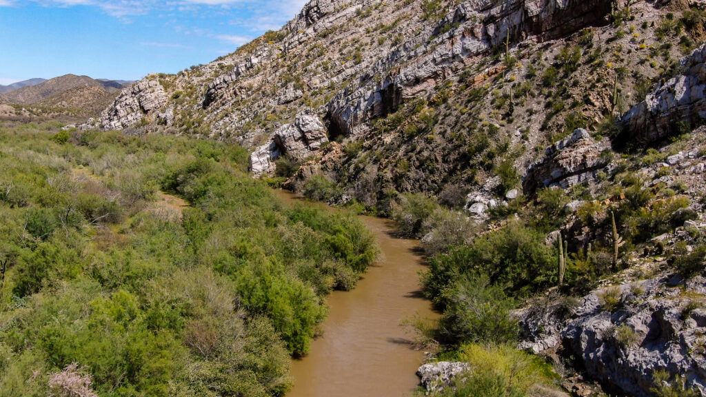
The Gila River near Winkelman, Arizona. Because the EPA’s new interpretation of the Clean Water Act no longer includes rivers that cross state boundaries, it may not include the Gila, which runs dry in stretches during much of the year. However, both Arizona’s and New Mexico’s state surface water protection programs include the river. (Mitch Tobin/The Water Desk)
In the Sackett decision’s aftermath, said Snyder, “arguably nowhere was more vulnerable than New Mexico.” According to her organization’s estimate, 96 percent of the state’s waterways lost federal protection thanks to the Supreme Court decision.
So, in January 2025 advocates and lawmakers responded with Senate Bill 21, the Pollutant Discharge Elimination System Act, which was signed into law by the governor on April 8, 2025.
The law oversees the waters that are no longer protected by the Clean Water Act, requiring a state-level discharge permit for any activity that no longer requires a federal one. In effect, the state is moving to protect what the federal government has abandoned.
“And if federal law continues to get narrower,” said Armstrong, “ours is elastic to continue filling the gap.” The nuts and bolts of the law’s implementation are being worked out, and the New Mexico Environment Department intends to begin issuing permits in early 2027.
In neighboring Arizona, about 95 percent of total stream miles are ephemeral. After the 2020 Navigable Waters Protection Rule, the state also created its own program to bridge the gap between the waterways protected by the narrowing federal oversight and those that the state considered important to regulate. The Arizona Department of Environmental Quality was given the authority to create a Surface Water Protection Program in 2021, and it became effective in 2023.
Like New Mexico’s SB21, Arizona’s Surface Water Protection Program is based on the Clean Water Act. It covers permitting and compliance, and imposes limits on discharge. With the federal law facing repeated re-interpretations, the state wanted to clearly establish which waterways required permits and oversight.
A dry stretch of the Gila River near Florence, Arizona. (Image: Mitch Tobin/The Water Desk)
“The definition of WOTUS keeps going up and down depending on which administration is proposing a rule,” said Trevor Baggiore, director of the Water Quality Division of the Arizona Department of Environmental Quality. “The idea is that the surface-water protection program provides a baseline that no matter what the federal rule does, the state rule is going to protect certain waters.”
Where New Mexico’s SB21 covers both intermittent and ephemeral waterways, Arizona’s Surface Water Protection Program covers only intermittent waterways and those ephemeral streams that feed into the state’s eight major rivers. When asked whether there are plans to expand Arizona’s program to include all ephemeral waters, Baggiore replied, “That’s a great question for state leadership.”
It would also be a good question for leadership in Texas, another border state whose arid western half has many intermittent and ephemeral waterways that federal rollbacks have left open to unrestricted dumping. In its 2025 legislative session, California lawmakers introduced Senate Bill 601, aimed at regulating discharge into waterways no longer covered by the Clean Water Act, but it did not advance to become law. (Colorado, for its part, created a program to require dredge-and-fill permits for wetlands, but has not moved to protect its ephemeral waterways.)
“Now that the federal government has walked away, it’s up to the states to say these waters matter or not,” said Snyder. “In New Mexico, the answer is loud and clear that yes, we have to step up, we’re going to protect them for future generations.”
Gross Reservoir, southwest of Boulder, Colorado, in October 2019. The reservoir, which supplies Denver Water customers on the Front Range, depends heavily on snowmelt. Photo by Mitch Tobin/The Water Desk. Aerial support provided by LightHawk.
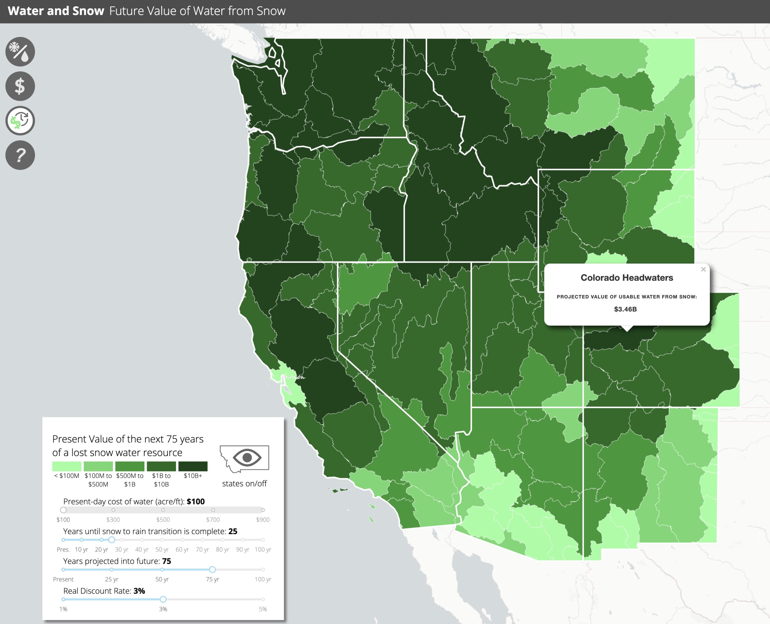
The American West’s snowpack is valuable for many reasons.
Snowmelt supplies much of the water flowing through the region’s streams, rivers, irrigation canals and household faucets—a vital role that has taken on new urgency this winter as much of the West struggles with scant snow cover.
Snowfall supports countless species, maintains forest health and helps keep a lid on wildfires. It even cools the planet by reflecting sunlight.
Snowflakes also underlie the region’s multi-billion-dollar winter sports industry, fueling local economies and drawing millions of participants. In warmer months, boating and fishing depend on water that was once frozen.
Snow performs all these functions, but can its worth be calculated in dollars and cents? And how is climate change affecting that value?
Like many aspects of nature, snow is easier to monetize in some domains than others. Its ecological benefits are complex, and its aesthetic qualities are subjective: some Westerners love the ice crystals, others dread them.
But in the economic realm, researchers have attempted to put a dollar figure on the region’s snow, and the numbers they’ve generated are huge.
“This stuff’s worth trillions, not billions” of dollars, said snow scientist Matthew Sturm, lead author of a widely cited 2017 paper in Water Resources Research that estimated the value of the water embedded in the West’s snowpack. “I turn on the tap in the Western states—what comes out of it is mostly snow.”
The Colorado River, which supplies drinking water to tens of millions of people and irrigates vast croplands, is primarily driven by snowmelt. The river generated an estimated $1.4 trillion in annual economic activity, according to a 2014 report commissioned by Protect the Flows, a business coalition, and conducted by Arizona State University. Adjusted only for inflation—not the region’s growth—that figure was equivalent to about $1.9 trillion in 2025, underscoring the high stakes of the ongoing, contentious negotiations over how to manage the Colorado River.
For some researchers, assigning a dollar value to snow is more than an academic exercise. In an era of tightening budgets and federal cutbacks in science, economic estimates can help justify investments in monitoring and studying snow—and highlight how much is at risk as the climate warms.
“If you want society to respond, you better talk about things that are fairly immediate, right at people’s doorsteps, and are easy to explain,” said Sturm, a professor of geophysics at the University of Alaska Fairbanks’ Geophysical Institute and the author of A Field Guide to Snow.
Or as Sturm’s paper puts it, “the ‘killer argument’ to the wider public that vigorous snow research is important would come by framing the argument in terms of money, something everyone understands.”
Peer-reviewed studies explicitly valuing the snowpack are rare, but some analyses have also calculated the sizable economic impact of snow sports. This winter, skiing and snowboarding in the West have been constrained not only by a lack of snowfall but also by record warmth that limited some resorts’ ability to make artificial snow.
A 2024 report from the National Ski Areas Association concluded that downhill snow sports generate $58.9 billion in annual economic activity in the United States and support an estimated 533,000 ski and snowboard jobs nationwide.
While the snowpack delivers tangible economic benefits—some easier to price than others—snowfall also carries real costs. Any accounting of snow’s economic impact must also reckon with the damage it causes.
Winter weather contributes to fatalities from avalanches in the mountains and from heart attacks in cities among people shoveling snow. But those deaths pale in comparison to the toll on slick roads. Each year, 24% of weather-related vehicle crashes happen on snowy, slushy or icy pavement, and 15% occur when snow or sleet is falling, according to the Federal Highway Administration. More than 1,300 people are killed and more than 116,800 are injured each year in crashes on snowy, slushy or icy pavement, the agency reports, though not all of those incidents are weather related.
The Animas River and San Juan Mountains in southwest Colorado in May 2023. The snowpack serves as a natural reservoir that releases water in warmer months. Photo by Mitch Tobin/The Water Desk. Aerial support provided by LightHawk.
Valuing the snowpack’s water
The 2017 paper began with a phone call that Sturm made to Michael Goldstein, a professor of finance at Babson College with whom he had previously collaborated.
“Hey, what do you think snowpack’s worth?” Goldstein recalled Sturm asking.
Goldstein wasn’t a snow expert, but he told Sturm, “If we make some simplifying assumptions here, I could value it for you.”
“I just thought it was a cool question,” said Goldstein, who is also the Donald P. Babson Chair in Applied Investments at Babson.
Since its publication, the study has been cited nearly 400 times, according to Google Scholar.
Viewed through an economic lens, the snowpack’s role as a mountain water tower provided a clear value that Goldstein could quantify.
“Nature naturally stores the water for you for free. You didn’t have to build a reservoir,” Goldstein said. “If that goes away, that actually has a cost. And the cost is the replacement cost of either storing the water or getting water from a different source.”
Climate change is already having a variety of profound effects on the West’s snow, such as shrinking the snowpack season, but the study focuses on one key impact: the shift from snow to rain as temperatures rise.
Even if total precipitation remains unchanged in the decades ahead, a transition from snow to rain—and faster melting of the snowpack—means runoff will occur earlier in the year. In much of the West, however, it may be impossible to capture all that earlier water for later use because dam managers must leave enough empty space in reservoirs to reduce the risk of catastrophic flooding.
“There is not enough reservoir storage capacity over most of the West to handle this shift in maximum runoff and so most of the ‘early water’ will be passed on to the oceans,” according to a 2005 study.
To estimate the declining value of the snowpack in a warming climate, the 2017 paper made some assumptions about the transition from snow to rain—an evolution expected to be more pronounced in warmer regions such as California and Oregon than in colder locations like the Northern Rockies.
Examining a range of future trajectories spanning five to 100 years, the researchers assumed that half of current snowfall would fall as rain by the end of the scenario.
For the 50% of snow that would eventually convert to rain, some of the water could be captured by existing reservoirs. But while Lake Mead and Lake Powell on the Colorado River currently have plenty of room to spare, the authors note that “virtually every report we have found on the heavily dammed water systems of the West suggests that reservoir capacity (except when immediately following drought) is maxed out.” As a result, the paper assumes that water systems would lose two-thirds of the reduced snowmelt runoff.
“We’re losing, essentially, the storage capacity of snow—meaning in lieu of snow, we get rain,” Sturm said.
With their estimates of the amount of water lost as snow shifts to rain, the researchers could then multiply those figures by the cost of water to begin determining the decline in monetary value. The paper uses two water prices to bracket its estimates: $200 and $900 per acre-foot (an acre-foot is the volume of water needed to cover an acre of land to a depth of 12 inches, or 325,851 gallons).
In reality, Goldstein said, the price of water would rise as supplies became scarcer. But the paper holds water prices constant over time, an assumption that yields a conservative estimate of the snowpack’s value.
This map shows the share of annual precipitation that falls as snow over land, based on data from 2000 to 2010. In the Northern Hemisphere, the area where 40% or more of precipitation falls as snow covers more than 5.8 million square miles. At its peak, snow typically blankets more than 22 million square miles of the Northern Hemisphere. Source: Drew Slater, National Snow and Ice Data Center, via Sturm et al. (2017).
Discounting the future
The price of water varies greatly across the West, so estimates of the snowpack’s value will necessarily span a broad range. But water costs aren’t the only reason it’s challenging to pin down the snowpack’s monetary worth.
Another challenge the paper grapples with is the changing value of money over time. Even in the absence of inflation, if someone offered you $100 right now versus $100 in a year, the economically rational choice would be to take the $100 today. After all, a lot can happen in a year—and you could invest the $100 in the meantime. But what if the offer were $105 or $110 a year from now?
To convert future benefits into today’s dollars, economists use a “discount rate” that accounts for risk and the preference for receiving payments sooner rather than later. A discount rate is “like the foreign exchange rate between consumption today and consumption tomorrow,” Goldstein said.
The choice of the discount rate can make a big difference in how future costs or benefits are calculated, and it’s often a pivotal factor in studies of the economics of climate change. In the snowpack paper, the authors use three discount rates—1%, 3% and 6%—although they omit the 6% rate in their final valuation “because it is fairly extreme and unlikely to be correct in a water-stressed future world.”
The higher the discount rate, the more heavily future losses are discounted, reducing the economic justification for acting today, such as acquiring new water supplies or building additional reservoirs.
Assumptions about the discount rate, the price of water and future climate trajectories all weigh heavily on estimates of the value of the snowpack’s water. In summary, the authors conclude that about 162 million acre-feet of water is deposited as snow in Western mountains each winter. If half of that snowfall were to fall as rain in the future—and two-thirds of that water were to run off to the ocean without being captured—water systems would lose roughly 53.9 million acre-feet per year. That volume is roughly the combined storage capacity of Lake Mead and Lake Powell, the nation’s two largest reservoirs.
The total replacement cost for the lost water ranged from $120 billion to $4.76 trillion, according to the 2017 study. By comparison, the federal government’s budget totaled about $3.85 trillion in fiscal year 2016.
“To date, a full financial evaluation of the importance of snow in our lives has not been made, but computations here and elsewhere indicate it is on the order of trillions of dollars,” the authors write.
The snowpack’s importance and value vary across the West, with some watersheds more dependent on snowmelt than others. To estimate the local impacts of future snowpack losses, researchers used data from the 2017 study and another paper to create an interactive map that shows the share of water in each Western river basin derived from snow and lets users adjust key variables, including the discount rate, the price of water and the rate at which snow transitions to rain.
An interactive map shows the present value of future snowpack losses across Western river basins. Users can adjust key assumptions—including the price of water, the discount rate and the pace of the transition from snow to rain—to see how projected losses change by watershed. Map by Matthew Sturm and Ryan Bateman, based on data from Li et al. (2017) and Sturm et al. (2017).
Investing in snow science
Jessica Lundquist, a professor of civil and environmental engineering at the University of Washington, called the paper “interesting and unique.” Lundquist, who wasn’t an author of the study but is acknowledged for advising the researchers, said the paper not only tried to put a dollar value on the snowpack but “also was trying to put a value on the knowledge.”
“I like the paper because it was a collaboration between a snow scientist and an economist,” Lundquist said. While the estimates of the snowpack’s value are uncertain, Lundquist said the study provides a useful framework for assessing the financial implications of water management strategies.
In a commentary on the 2017 paper, subtitled “Investments in snow pay high-dollar dividends,” Lundquist wrote that the study “puts the value of snow one thousand times higher than the estimates of snow based on tourism alone.”
When the commentary was published, snow scientists were trying to convince NASA to launch a satellite mission to study the snowpack.
“We were often getting questions about what is the value not only of snow, but of studying snow,” Lundquist said.
A satellite dedicated to monitoring snow never launched. But scientists continue to track the snowpack using other spacecraft, along with a suite of tools that includes aircraft, automated stations and manual measurements.
“I think we’re getting progressively better at figuring out how much snow is in the mountains,” Lundquist said. “I think we’ve made tremendous progress in the last 10 years that we can actually quantify it quite well with a number of ways.”
In other parts of the world, however, snowpack monitoring may be very limited. “A lot of what still needs to be done is in other mountain ranges, other places that don’t have these observing networks,” Lundquist said. “There’s a lot of people who depend on water from the Himalaya who just have no idea whether it’s going to be a drought year or a flood year or what is upstream at all.”
The Yampa River, upstream from Steamboat Springs, Colorado, in December 2019. The Yampa is a tributary of the Green River, which feeds into the Colorado River—the water source for tens of millions of people. Photo by Mitch Tobin/The Water Desk.
Recreational impact of a shrinking snowpack
Beyond supplying water, the West’s snowpack also underpins the region’s winter recreation economy.
During the 2024–25 season, U.S. ski areas recorded 61.5 million skier visits, according to the National Ski Areas Association. This winter, however, visitation across much of the West has suffered amid a widespread snow drought.
In January, Vail Resorts, which is publicly traded on the New York Stock Exchange, reported that visits to its mountains so far this season were down 20% compared to last season, primarily because of poor snow conditions. In the Rockies, only about 11% of the company’s terrain opened in December, when snowfall was nearly 60% below the 30-year average.
A number of studies have examined how changes in the snowpack affect ski areas—both historically and in future projections.
Between 1999 and 2010, the U.S. downhill ski industry lost an estimated $1.07 billion in revenue between low- and high-snowfall years, resulting in 13,000 to 27,000 fewer jobs, according to a 2012 analysis by University of New Hampshire researchers. The report was commissioned by Protect Our Winters and the Natural Resources Defense Council, two advocacy groups.
A 2024 study estimated that U.S. ski areas lost more than $5 billion from 2000 to 2019 due to fewer visits and higher snowmaking costs. Compared to the 1960-1979 period, ski seasons from 2000 to 2019 shortened by 5.5 to 7.1 days, according to a model of operations at 226 ski areas.
Looking ahead, the study projected that by the 2050s, ski seasons would shrink by 14 to 33 days under a low greenhouse gas emissions scenario and by 27 to 62 days under a high-emissions pathway. Under those scenarios, annual industry losses ranged from $657 million to $1.35 billion.
The 2024 study accounted for the added expenses of snowmaking, which requires investments in equipment and labor while also increasing water and energy use. It did not, however, include the broader ripple effects of shorter ski seasons on surrounding communities, where hotels, restaurants, bars, retailers, and gas stations depend heavily on tourists’ spending.
A 2017 study examining future climate impacts on skiing and snowmobiling analyzed 247 winter recreation locations across the continental United States and projected how warming would shorten seasons. The authors concluded that “virtually all locations are projected to see reductions in winter recreation season lengths, exceeding 50% by 2050 and 80% in 2090 for some downhill skiing locations.”
Those shorter seasons “could result in millions to tens of millions of foregone recreational visits annually by 2050, with an annual monetized impact of hundreds of millions of dollars,” the researchers wrote. They also noted that limiting greenhouse gas pollution “could both delay and substantially reduce adverse impacts to the winter recreation industry.”
A smaller, less reliable snowpack can also affect summertime recreation by reducing streamflows and reservoir levels that support fishing, boating and other water-based activities.
In Colorado, for example, outdoor recreation accounted for 3.2% of the state’s gross domestic product in 2023, according to the Bureau of Economic Analysis. Boating and fishing generated $689 million in economic activity in the state, while snow-related recreation was valued at $1.56 billion—more than any other state.
Limited natural snow cover on a rainy Christmas Day in 2025 at Colorado’s Crested Butte ski area. As winters warm and precipitation increasingly falls as rain rather than snow, ski resorts face growing challenges. Photo by Mitch Tobin/The Water Desk.
Other benefits—and costs—of snow
The snowpack’s importance to winter recreation and the West’s water supply are among the easier values to quantify, but they’re not the only benefits snow provides.
On a global scale, one of the most valuable functions of frozen water is that it reflects far more sunlight than bare ground or open ocean. This reflectivity—a property known to scientists as albedo—helps cool the planet.
A 2013 study examining the thawing Arctic attempted to monetize the loss of that cooling effect. The decline in Arctic snow and ice—along with increased methane emissions from melting permafrost—was estimated to cost society $7.5 trillion to $91.3 trillion from 2010 to 2100. “The frozen Arctic provides immense services to all nations by cooling the earth’s temperature—the cryosphere is an air conditioner for the planet,” the scientists wrote.
Then again, the loss of snow could reduce some costs to society.
“There’s some side benefits,” Goldstein said. “You might not have a flood because you’re not going to have a massive runoff all at the same time. That does happen. Some things will be reduced.”
If snow disappeared, so too would snow days that disrupt travel and hamper economic productivity. Winter road maintenance accounts for roughly 20% of state transportation department maintenance budgets, according to the Federal Highway Administration, which estimates that state and local agencies spend more than $2.3 billion annually on snow and ice control annually.
Between 1980 and 2024, the United States experienced 24 winter storms that each caused more than $1 billion in damages, according to the National Centers for Environmental Information. Collectively, those disasters cost $104.2 billion and claimed 1,453 lives.
While vehicle crashes, skier visits and acre-feet of snowmelt can be quantified and priced, snow’s benefits and costs also encompass many things that are difficult—if not impossible—to calculate.
In many ecosystems, for example, snow and snowmelt are vital for plants and animals that have their own economic value, not to mention their intrinsic worth. The 2017 snowpack study did not attempt to price these so-called ecosystem services, which include keeping forests healthy, maintaining cold-water fisheries and sustaining biological diversity.
Even more challenging to value are the mix of emotions that snow evokes. Beauty—and misery—are in the eye of the beholder.
“Some people want their white Christmas,” Lundquist said, “and others are like, please don’t shut down my city.”
The Colorado River, near Bond, Colorado, in December 2019. The river generated an estimated $1.4 trillion in annual economic activity, according to a 2014 report. Photo by Mitch Tobin/The Water Desk.
This story was produced by The Water Desk, an independent journalism program at the University of Colorado Boulder’s Center for Environmental Journalism.