Castle Rock Water Conservation Specialist Rick Schultz, third from the right, inspects and tests a new landscape watering system in Castle Rock, one of many Douglas County communities reliant on the shrinking Denver Aquifer. In a Fresh Water News analysis of water conservation data, Castle Rock leads the state, having reduced its use 12% since 2013. Oct. 21, 2020. Credit: Jerd Smith, Fresh Water News
By Allen Best
With the Colorado River crisis deepening and the warming climate continuing to rob streams and rivers of their flows, talk in Colorado has resumed about how to limit growing water demand statewide for residential use.
A new report commissioned by the Common Sense Institute and written by Colorado water veterans Jennifer Gimbel and Eric Kuhn, cites the need for broader conservation measures such as removing non-functional turf in new development, among other things.
“Regional approaches are needed,” they added in their broad-ranging report. They suggest regional conservancy and conservation districts might be a vehicle in lieu of statewide standards.
Gimbel, a senior scholar at CSU’s Water Center and former director of the Colorado Water Conservation Board, and Kuhn, retired general manager of the Colorado River Water Conservation District, summarized their findings last Friday in a presentation at the Colorado Water Congress Annual Convention. The water congress is a bi-partisan group representing dozens of water users across the state.
“We have to do more with less,” said Kuhn. He cited projected statewide population growth of 1.6 to 1.8 million new residents by 2050, most along the Front Range, but also the probability that the warming climate will make less water available, particularly from the Colorado River.
Kuhn warned that deliveries of water from the Colorado River Basin to the Front Range are by no means guaranteed. Several Front Range water providers, including Pueblo, Denver and Northern Water have at least some water rights that are younger, or more junior than those farther downstream in places such as California, and could be vulnerable if mandatory cutbacks ever occurred. Within individual states in the West, older water rights are typically fulfilled before younger water rights during times of scarcity, though it’s yet to be seen how mandatory cutbacks would materialize across the entire Colorado River Basin.
“Curtailment of those junior users is not acceptable at any time in the future,” said Kuhn.
Earlier during the conference, Colorado Gov. Jared Polis called for a “comprehensive approach to housing to preserve our water resources.” He cited multiple benefits for revised land-use policies: reduced traffic, saved money for consumers and – most important, he added, it “limits demand on water resources.”
Polis said the Colorado Water Conservation Board will lead a task force on integrating land use and water demand. This 21-member Urban Landscape Conservation Task Force is to include representatives of 8 water utilities, 2 conservation districts, 2 environmental NGOs, with the balance to come from areas of expertise and interest such as stormwater, equity, and urban planning.
Local control, a basic precept of Colorado’s form of government, will also likely be an issue. Towns, cities and counties who are authorized to govern themselves in most cases, often resist state control in matters they believe should remain in local hands.
Aurora, if lately a shining light for turf removal and strict water conservation policies, harbors skepticism of any potential statewide mandates. “Aurora must retain control of what our city looks like,” says Greg Baker, Aurora Water’s spokesman.
Aurora is open to discussion but “it needs to be a proportional discussion,” says Baker. “We don’t want to tell agriculture how to use their water, but they account for 85% of water use in this state.”
In 2014, when Ellen Roberts, then a state senator from Durango, introduced a conservation bill, she found significant opposition.
Roberts said she introduced the bill, which did not pass, to get the conversation going in Colorado about stepped-up conservation programs. “My concern was that if we waited for that to happen naturally, it might never happen or it would be so slow it would have no meaningful impact,” she says.
This latest report was designed for the business community, says Gimbel, but with the understanding that it needed to include the water community. “It was our opportunity to tell the business community ‘pay attention, because what happens with water is going to affect our economy one way or another.’”
Allen Best grew up in eastern Colorado, where both sets of grandparents were farmers. Best writes about the energy transition in Colorado and beyond at BigPivots.com.
Fresh Water News is an independent, nonpartisan news initiative of Water Education Colorado. WEco is funded by multiple donors. Our editorial policy and donor list can be viewed at wateredco.org.
The Water Desk’s mission is to increase the volume, depth and power of journalism connected to Western water issues. We’re an initiative of the Center for Environmental Journalism at the University of Colorado Boulder. The Water Desk launched in April 2019 with support from the Walton Family Foundation. We maintain a strict editorial firewall between our funders and our journalism.
This beaver dam analogue, with posts across the creek and soft, woody material woven across, was built by environmental restoration group EcoMetrics, keeps water on the landscape by mimicking beaver activity. The state Department of Natural Resources has penned draft legislation clarifying that this type of restoration project does not need a water right. CREDIT: JACKIE CORDAY
By Heather Sackett
Colorado officials have drafted a bill aimed at addressing a tension between stream restoration projects and water rights holders.
The draft clarifies that restoration projects do not fall under the definitions of a diversion, storage or a dam and do not need to go through the lengthy and expensive water court process to secure a water right.
But before a project begins, proponents would have to file an information form with the state Division of Water Resources showing the project will stay within the historical footprint of the floodplain before it was degraded and doesn’t create new wetlands, the draft bill proposes. These forms would be publicly available, and anyone could then challenge whether the project meets the requirements by filing a complaint, which would be taken up by DWR staff.
If stream restoration projects were required to secure a water right and spend money on an expensive augmentation plan, in which water is released to replace depletions it causes, it could discourage these types of projects, something the state Department of Natural Resources wants to avoid.
“We are trying to make it clear that stream restoration projects do not fall under the definition of diversion,” said Kelly Romero-Heaney, the state’s assistant director for water policy. “However, we put limits on what a restoration project is or isn’t and the restoration project has to fall within the historical footprint of the stream system.”
This stream restoration project on Trail Creek, in the headwaters of the Gunnison River, mimics beaver activity. Some worry that projects like this have the potential to negatively impact downstream water rights. CREDIT: JACKIE CORDAY
Slowing the flow
Restoration projects on small headwaters tributaries often mimic beaver activity, with what are called beaver dam analogues. These temporary wood structures usually consist of posts driven into the streambed with willows and other soft materials woven across the channel between the posts. The idea is that by creating appealing habitat in areas that historically had beavers, the animals will recolonize and continue maintaining the health of the stream.
The goal of process-based restoration projects like these is to return conditions in the headwaters to what they were before waterways were harmed by mining, cattle grazing, road building and other human activities that may have confined the river to a narrow channel and disconnected it from its floodplain.
In these now-simplified stream systems, water, sediment and debris all move downstream more quickly, said Ellen Wohl, a fluvial geomorphologist at Colorado State University.
“Natural rivers have all these sources of variability,” Wohl said. “They have pools and riffles, meanderings, obstructions like wood and beaver dams. All those things can help slow the flow, which leads to less bed and bank erosion. It allows sediment to be deposited gradually along the channel, and you increase biological processing and recharge of ground water and soil moisture.”
Although these projects benefit the environment, improve water quality and create resiliency against wildfires and climate change, keeping water on the landscape for longer could potentially have impacts to downstream water users. Under Colorado’s system of prior appropriation, the oldest water rights — which nearly always belong to agriculture — have first use of the water.
Some are concerned that if the projects create numerous ponds in the headwaters, it could slow the rate of peak spring runoff or create more surface area for evaporation, meaning irrigators may not get their full amount of water.
John McClow is an attorney for the Upper Gunnison River Water Conservancy District and is chair of a Colorado Water Congress sub-committee studying the bill, which will make suggestions to the bill’s sponsors. He said there have been wet meadow restoration projects in the headwaters of the Gunnison River that have harmed water rights holders.
“We had some examples of well-intentioned but poorly designed projects,” he said. “In each case we worked with water rights holders and removed the obstruction so their water rights were not impaired.”
McClow said he would like to see the bill set a standard to avoid problems at the outset of projects.
State Sen. Dylan Roberts, who represents District 8 and is chair of the Agriculture and Natural Resources Committee, is one of the bill’s sponsors. He said part of the bill’s urgency is so that Colorado can take advantage of unprecedented federal funding for stream restoration from the Infrastructure Investment and Jobs Act and the Inflation Reduction Act.
“If we can demonstrate to the federal government that we have a streamlined process for stream restoration projects, then we will make Colorado significantly more eligible for those federal funds,” Roberts said. “We are trying our best to position our state to receive the resources that we deserve.”
Roberts, a Democrat whose Western Slope district includes Eagle, Garfield, Grand, Moffat, Rio Blanco, Routt and Summit counties, expects the bill to be introduced later this month.
Romero-Heaney said the state’s system of water law works well because it is adaptable to the evolving needs of Coloradans. The stream restoration legislation aims to reduce barriers to projects while still protecting water rights.
“We are at that moment where we need to make a decision: Do we want to have a future with healthy streams that are providing all those environmental services, or do we want to make that future pretty difficult to achieve?” she said. “It’s a soul-searching conversation for the water community.”
The Water Desk’s mission is to increase the volume, depth and power of journalism connected to Western water issues. We’re an initiative of the Center for Environmental Journalism at the University of Colorado Boulder. The Water Desk launched in April 2019 with support from the Walton Family Foundation. We maintain a strict editorial firewall between our funders and our journalism.
Shoshone hydropower plant has the most senior, large-volume water right on the Colorado mainstem. The bonus for other users is that the water returns to the river after producing electricity. Photo By: Kevin Moloney
By Allen Best
Two proposed pumped water storage projects that could expand Colorado’s ability to store renewable energy – one in Fremont County and another between Hayden and Craig in the Yampa River Valley – are moving forward.
Colorado will need green energy storage of some type if it is to attain its mid-century goals of 100% renewable energy. Solar and wind power are highly variable and cannot be turned off and on, like coal and natural gas plants are.
So the search is on for ways to build large-scale storage projects to hold the energy wind and solar generate. Lithium-ion batteries are part of the answer and are being rapidly added to supplement wind and solar. But they typically have a short life span, while pumped water storage hydropower projects can operate for decades.
Pumped water storage has been refined in recent decades but the basic principles remain unchanged. Water is released from a higher reservoir to generate power when electricity is most in demand and expensive. When electricity is plentiful and less expensive, the water is pumped back up to the higher reservoir and stored until it is needed again.
This technology even today is responsible for 93% of energy storage in the United States, according to the U.S. Department of Energy. That includes Cabin Creek, Xcel Energy’s 324-megawatt pumped storage unit near Georgetown. It was installed in 1967.
“These pumped-storage projects are anathema to the modern way of thinking,” says Peter Gish, a principal in Ortus Climate Mitigation, the developer of the Fremont County pumped water storage project.
“But once built and operating, the maintenance costs are very, very low, and the system will last, if properly maintained, a century or longer. The capital investment up front is quite high, but when you run the financial models over 30, 50 or 60 years, this technology is, hands down, the cheapest technology on the market for [energy] storage.”
Ortus Climate Mitigation wants to build a 500-megawatt pumped water storage facility on the South Slope of Pikes Peak above the town of Penrose in Fremont County. This facility – essentially a giant battery for energy storage – would require two reservoirs.
Gish hopes to have a permit from the Federal Energy Regulatory Commission in 2026. Construction would take up to five years after the permit is approved.
In the Yampa Valley, another developer continues to plug away at a potential application for a site somewhere between Hayden and Craig. Still another idea is said to be in formulation in southwestern Colorado, but no details could be gleaned about that project.
Phantom Canyon, as Ortus calls its project in Fremont County, would require 17,000 acre-feet of water for the initial fill of the two reservoirs to be augmented by about 1,500 acre-feet annually due to losses from evaporation.
The company says it has accumulated water rights.
Gish, a co-founder of Ortus, says his company is “keenly aware” of water scarcity issues in Colorado and looks into ways to reduce the evaporative loss and hence shave water needs. One option is to place solar panels over the reservoirs, producing energy while shading the water. On a vastly smaller scale, that has been done at the Walden municipal water treatment plant in north-central Colorado.
Unlike an unsuccessful attempt by Xcel in 2021 to build a pumped water storage project in Unaweep Canyon on federal land in Western Colorado, the Ortus project near Pikes Peak would involve only private land. The company has exclusive purchase options for 4,900 acres. It also has secured 12 easements for pipeline access from the lower reservoir to the Arkansas River.
Proximity to water sources matters, and so does the location relative to transmission. Penrose is about 30 miles from both Colorado Springs and Pueblo and major transmission lines.
The company last year laid out the preliminary plans with Fremont County planners and hosted a meeting in Canon City to which environmental groups and others were invited. By then, FERC had issued a preliminary permit which is the start of the permitting process. Gish, who has worked in renewable energy for 25 years, says no potential red flags were noted.
“I have found that the local stakeholders are the first people you need to talk to about a project like this,” Gish says, “If you are able to get local support, the rest of the pieces will tend to fall into place. If not, the rest of the process is a much more difficult proposition.”
In Western Colorado, Xcel faced local opposition but also the more daunting process of permitting for a project on federal land. In the Craig-Hayden area, Matthew Shapiro, a principal in green energy company Gridflex Energy, had been examining sites that are on private land. Work continues on geological assessments and other elements, but he says that a “lot of other pieces need to come together before there is real progress.”
In addition to having water, that portion of the Yampa Valley also has the advantage of transmission lines erected to dispatch power from the five coal-burning units that are now scheduled to close between 2025 and 2030.
Shapiro hopes to also use Colorado-sourced water to generate electricity in a pumped-storage project on the North Platte River in Wyoming. Gridflex Energy filed for a license application with FERC last week for the project on Seminoe Reservoir.
“Very few projects have made it that far since the turn of the millennium. It’s a pretty big deal,” Shapiro said.
Long-time Colorado journalist Allen Best produces an e-journal called Big Pivots and is a frequent contributor to Fresh Water News.
Fresh Water News is an independent, nonpartisan news initiative of Water Education Colorado. WEco is funded by multiple donors. Our editorial policy and donor list can be viewed at wateredco.org.
The Water Desk’s mission is to increase the volume, depth and power of journalism connected to Western water issues. We’re an initiative of the Center for Environmental Journalism at the University of Colorado Boulder. The Water Desk launched in April 2019 with support from the Walton Family Foundation. We maintain a strict editorial firewall between our funders and our journalism.
The Rio Grande Gorge near Taos, New Mexico. Photo by The Water Desk.
The Water Desk is now accepting applications for awards of $2,500 to $10,000 to support media outlets and individual journalists covering water issues related to New Mexico and the Rio Grande.
The deadline for applications is Monday, April 17, 2023, at 11:59 pm Mountain.
This program is only open to journalists (freelance and staff) and media outlets.
The geographic scope for this program is New Mexico and the Rio Grande Basin. All proposals must have a strong connection to either New Mexico water issues or the Rio Grande watershed in Colorado, New Mexico, Texas and/or Mexico.
The Water Desk is interested in supporting a wide variety of media and journalistic approaches: newspapers, magazines, websites, video, television, radio, podcasts and other channels.
Because water is intertwined with so many issues, we are open to proposals covering a broad spectrum of topics: climate change, biodiversity, pollution, public health, environmental justice, food, agriculture, drinking water, economics, recreation and more.
Funding for this program comes from the Thornburg Foundation and Santa Fe Community Foundation. As a journalistic initiative, The Water Desk maintains a policy of strict editorial independence from our funders, as well as from the University of Colorado Boulder. Funders of The Water Desk have no right to review nor influence stories or other journalistic content that is produced with the support of these awards. For more on our policies, please see our funding page.
When the Colorado River Compact was signed 100 years ago, the negotiators for seven Western states bet that the river they were dividing would have ample water to meet everyone’s needs – even those not seated around the table.
A century later, it’s clear the water they bet on is not there. More than two decades of drought, lake evaporation and overuse of water have nearly drained the river’s two anchor reservoirs, Lake Powell on the Arizona-Utah border and Lake Mead near Las Vegas. Climate change is rendering the basin drier, shrinking spring runoff that’s vital for river flows, farms, tribes and cities across the basin – and essential for refilling reservoirs.
The states that endorsed the Colorado River Compact in 1922 – and the tribes and nation of Mexico that were excluded from the table – are now straining to find, and perhaps more importantly accept, solutions on a river that may offer just half of the water that the Compact assumed would be available. And not only are solutions not coming easily, the relationships essential for compromise are getting more frayed.
With the Compact’s shortcomings and the effects of climate change and aridification becoming as clear as the bathtub ring around Lake Mead, previous assumptions of how much water the river can provide and the rules governing how it gets divvyed up must be revised to reflect the West’s new hydrology. One thing is certain among experts and Colorado River veterans: Water cuts are in the short-term and long-term forecast for major cities such as Los Angeles, Las Vegas and Phoenix, as well as farmers from Colorado’s West Slope to growers in California’s Imperial Valley near the Mexican border.
“You don’t have any other arrow in your quiver right now except to reduce use,” Pat Mulroy, former general manager of the Southern Nevada Water Authority, told a gathering of Colorado River water interests this fall. “There are no other arrows.”
The River’s Changing Math
Predicting the amount of water the Colorado River can provide in a given year has always been a challenge. The river’s flow is famously erratic, dictated by the size of the often-fickle Rocky Mountain snowpack and other variables such as soil moisture and changes in temperature.
The old expectations of the Compact signers is giving way to a new reality on the river. Over the last century, the river’s flows in the Upper Basin have dropped by 20 percent. Scientists have pinned warming temperatures as the main cause of the disappearing flows and predict the trend will worsen as the Upper Basin, source of most of the river’s water, becomes even hotter and drier.
Water users have been able to counter previous dry spells by relying on the river’s main reservoirs. But after more than two decades of drought, both Lake Mead and Lake Powell are only about one-quarter full. The reservoirs’ rapid declines have forced the Bureau of Reclamation to order unprecedented water cuts to Arizona and Nevada. Mexico is taking similar cuts under binational agreements. And Reclamation has warned more severe actions are needed to prevent the collapse of the Colorado River system.
The Compact signatories, relying on data from a small but abnormally wet time period, estimated the river’s annual average natural flow in the Upper Basin to be about 18 million acre-feet. The figure, they asserted, was enough to cover 7.5 million acre-feet of water in perpetuity for the Upper Basin states of Colorado, New Mexico, Utah and Wyoming, and 7.5 million acre-feet for the Lower Basin states of Arizona, Nevada and California. They also agreed that any water committed to Mexico would be supplied equally by the two Basins. Native American tribes, who now legally hold substantial rights to the river’s water, were barely mentioned.
Brad Udall, Colorado State University climate researcher, said it’s becoming harder and harder for the river to meet the promises outlined in the Compact and the accompanying set of agreements, laws and court cases referred to as the Law of the River. He warned dozens of water managers and policy experts at a recent Water Education Foundation Symposium that climate change caused by greenhouse gas emissions is rapidly and permanently shifting precipitation trends in the Basin.
“It’s not a drought, it’s not temporary, it’s aridification,” said Udall. “Additional 1 degree Celsius or more warming by 2050, Lee Ferry flows in 9 million acre-feet are possible. Every important trend line [is] heading in the wrong direction, notably our reservoirs, but all the science trends as well.”
Data from recent decades shows it’s becoming uncommon for the river to meet the benchmark used to craft the Compact. Estimated annual flows at Lee Ferry, a key dividing point between the Colorado River’s Upper and Lower Basins, have surpassed 18 million acre-feet just four times since 1991, while the river’s average flow since 2000 has been 12.3 million acre-feet.
“If we’re taking out more than comes in, it is really simple math that the reservoirs are going to continue to decline,” said Rebecca Mitchell, director of the Colorado Water Conservation Board, the state’s water management agency.
Mitchell was among nearly 200 state and regional water managers, farmers, tribal leaders and other water interests from the seven Basin states, along with key federal and Mexican officials, who attended the Foundation’s biennial Colorado River Symposium in late September to mark the Compact’s 100th anniversary and to discuss the risks and challenges ahead for the iconic Southwestern river.
Discussions were sometimes sobering and sometimes tense, underscoring the growing risks to a river depended upon for drinking water by 40 million people and for irrigation of more than 4 million farmland acres across the Basin. An undercurrent of the discussions was whether Basin interests can avoid taking their differences to court – a prime motivation behind creating the 1922 Compact. Despite the occasional sharply worded airing of differences between Upper and Lower Basin interests, there was broad acknowledgement that action is needed to keep the river system functioning.
Reclamation Commissioner Camille Calimlim Touton was among those urging water interests throughout the Basin to continue working collaboratively toward solutions and she provided a broad outline of actions that federal officials are preparing to take in 2023 – including reducing water releases from Lake Powell and Lake Mead – to keep the river from crashing.
“The actions we choose to take over the next two years,” Touton told participants, “will define the fate of the Colorado River for the next century.”
Living Within New Means
Though the Colorado River’s annual yield has shrunk in the 21st century, demand for its diminishing supply hasn’t, creating a glaring math problem for Basin water managers. In a system where every drop of water is already allocated, the specter of an 11 million acre-foot river — or worse — is forcing users to prepare for a drier future.
One agency that has been actively finding ways to stretch its river supply is Southern Nevada Water Authority, which serves more than 2 million people in the Las Vegas area. The agency has updated its modeling and long-range planning to reflect the river’s changing hydrology.
John Entsminger, the authority’s general manager, said computer models are sending a direct warning that the Lower Basin will end up with only a slice of the 7.5 million acre-feet per year outlined in the Compact. After accounting for evaporation and system losses, he said, it’s probable the Lower Basin and Mexico will have much less water to split.
“It is incumbent upon the Lower Basin to come up with a plan to live within its 7 million acre-feet release from Lake Powell probably forever going forward and hope it’s not less than that,” said Entsminger.
Like Nevada, Arizona is already feeling the pinch from the latest round of federal water cuts. So far, the two states and Mexico have shouldered most of the pain.
In 2022, Arizona is using approximately 2 million of its 2.8 million acre-feet Colorado River allocation, according to state officials The state’s agricultural industry is taking the hardest hit, including one rural county that fallowed more than 50 percent of its farmland for lack of irrigation water.
“We’re already seeing huge pain, and with an 11 million acre-feet [river] that pain’s just going to continue to grow,” said Tom Buschatzke, Arizona Department of Water Resources director.
The widening gap between supply and demand is also having an impact above Lee Ferry, where inflows into Lake Powell continue to fall below historical average. Water from Powell is critical for helping the Upper Basin meet its commitment under the 1922 Compact to deliver water to the Lower Basin.
Representatives from the Upper Basin states say they have collectively cut their annual consumptive river use from 4.5 million acre-feet to approximately 3.5 million acre-feet over the last three years. Over the same period, they argue, the Lower Basin has done little to reduce its own consumptive use. Similar to Arizona, Upper Basin farmers also have been on the receiving end of water cuts.
The Ute Mountain Ute Tribe has fallowed the majority of its farmland in southwestern Colorado while in Wyoming, more than 100,000 acres of farmland were cut off from surface water for most of August because of low stream flows in the Upper Basin.
“That equates to about 100,000 acre-feet of [diverted Colorado River water] a month…that’s a third of our average irrigated use,” said Brandon Gebhart, Wyoming State Engineer.
The Upper Basin states have proposed a five-point plan built around paying farmers to reduce water consumption. Though it doesn’t require mandatory cuts for water users, proponents say the success of the plan hinges on whether the Lower Basin agrees to leave more water in Lake Mead.
“I think we need to recognize that the uses are far outweighing what Mother Nature is providing and that is primarily not in the Upper Basin,” said Mitchell with the Colorado Water Conservation Board.
California In the Spotlight
California’s use of the river has been a sore point among others in the Colorado River Basin. California, the largest user of Colorado River water, has been spared from water cuts so far due to its senior priority rights and has been using its full 4.4 million acre-feet entitlement in 2022. Groups in both the Upper and Lower Basins say the state must significantly reduce its use to prevent the river system’s collapse.
California water agencies and state officials have pushed back on criticism that they aren’t doing enough to help buoy the shrinking reservoirs.
Peter Nelson, chairman of the Colorado River Board of California, argued California delayed the current crisis by enacting voluntary deals that pay farmers not to plant their fields, transfer water to urban users or make their systems more water efficient.
“In the Lower Basin, since the last seven years or so, we’ve stored 1.5 million acre-feet of water in Lake Mead as Intentionally Created Surplus water,” said Nelson, who farms in the Coachella Valley. “That has enabled the lake levels at Lake Mead to stay high enough to stay out of shortages and benefit other states in the Basin.”
Though the state is using its full share amid another bitterly dry year on the Colorado River, California water managers say they are not dismissing the fact that the river is overprescribed and that future cuts are needed. But they warn that the state’s farmers shouldn’t be made the scapegoat for all the Basin’s water problems.
For example, cutting off water to farmers in the Imperial Valley may help solve one crisis but simultaneously cause another, said Henry Martinez, general manager of the Imperial Irrigation District. Agriculture overwhelmingly drives Imperial County’s economy, he said, so fallowing would lead to major job losses in a region already prone to high poverty and unemployment rates.
“You can devastate the whole industry by making the wrong cutbacks at the wrong time. There has to be consideration also as to how to prop up or maintain the economy of the region, otherwise you go from a very poor area to devastating even furthermore the economy,” said Martinez.
In response to Reclamation’s call this summer for river users to voluntarily conserve 2 million to 4 million acre-feet of water in 2023 to protect Lake Mead and Lake Powell, Imperial Irrigation District and other California agencies on Oct. 5 proposed a plan that would save 400,000 acre-feet — 9 percent of California’s river allocation — each year between 2023 and 2026.
Earlier this month, the Department of the Interior approved the deal, committing $250 million from the Inflation Reduction Act to kickstart the conservation plan and support Salton Sea restoration efforts. As a result of water conservation efforts and a long-term transfer of farm water from the Imperial Valley to urban San Diego, the sea has been shrinking, exposing more lakeshore to winds that blow hazardous, lung-choking dust into the region.
California’s offer has received mixed reviews throughout the Basin: Some have applauded the proposal and called it an encouraging first step from the river’s biggest user, but others have cast it as an underwhelming opening gambit.
Wade Crowfoot, California Natural Resources Agency Secretary, said the Basin must continue negotiating and taking advantage of federal aid earmarked for Western drought relief to spur water conservation.
“As challenging and as tense as this is, I think that there’s a real opportunity and that failure is not an option,” said Crowfoot. “Everybody understands we have to figure this out and we have some resources at our disposal.”
“We can’t be caught flat-footed.”
In June, Reclamation Commissioner Touton told a U.S. Senate panel that unless an emergency conservation deal was reached by river users in 60 days, the federal government would have to take unilateral action to prevent the system’s demise.
But the deadline passed without a deal and there was no immediate federal response, causing water users to wonder whether repercussions were coming. With little progress on a watershed-wide conservation plan, some Colorado River veterans contend the federal government should take a direct role in facilitating negotiations.
“I think Reclamation is going to have to get some key players in the room, probably including Mexico, and really get down to the brass tacks of leveraging and what needs to be done,” said Tom Davis, general manager of the Yuma County Water Users’ Association. “We need to save this patient’s life in the next 24-36 months.”
Touton’s demand that the Basin states cut 2 million to 4 million acre-feet caught them off guard, said Bruce Babbitt, former Interior secretary and Arizona governor. Since the announcement, Babbitt said, the states have essentially been “stumbling around” in the absence of a well-defined negotiation framework.
Babbitt likened the current situation to the one 100 years ago, when the states’ negotiations on how to split the Colorado River had also stalled before President Warren Harding tapped Herbert Hoover to guide the talks. Babbitt told the September symposium there are important lessons to be taken from the structured discussions at Bishop’s Lodge, just outside of Santa Fe, N.M., that ultimately led to the formulation of the 1922 Compact.
“What finally emerged out of that in terms of process at Bishop’s Lodge is something that I think we need to reflect on because we’re going to have to put together a workable framework,” Babbitt added.
Federal officials contend there isn’t a leadership void.
David Palumbo, Reclamation’s deputy commissioner of operations, said Reclamation is preparing a suite of actions — including reducing releases from Lake Powell in 2023 — to prevent a scenario where water can’t flow out of the system’s main dams.
“If we need to release less than 7 million acre-feet [from Glen Canyon Dam] … if that hydrology is not there, we’re going to have to do something to avoid the crash and we’re going to be prepared to do that,” said Palumbo. “We can’t be caught flat-footed.”
With talks between the states and tribes at a standstill, Interior Secretary Deb Haaland on Oct. 28 announced the federal government is considering deviating from operating rules established in 2007 and 2019 to handle water shortages on the river.
During recent public briefings, federal officials have indicated that Lake Powell releases may be slashed by 2 to 3 million acre-feet annually to keep the reservoir from reaching a point where it could no longer generate electricity or deliver water downstream.
Meanwhile, Reclamation is now offering Lower Basin water users up to $400 per acre-foot of conserved water over the next three years, part of the $4 billion in drought relief funding secured through the Inflation Reduction Act. In addition, at least $500 million will be reserved for water conservation and efficiency projects in the Upper Basin.
Some Colorado River veterans, including Colby Pellegrino, deputy general manager of resources for the Southern Nevada Water Authority, are urging Reclamation to focus the federal drought relief on actions that will not just temporarily halt Lake Mead’s decline, but permanently change water use habits.
“We should be using that money to fundamentally change the way we do everything in this Basin to use the least amount of water possible,” she said.
Considering the scope of the damaging economic, social and ecosystem impacts that would flood the Basin if Lake Mead or Lake Powell were to reach dead pool, others argue Congress should get more involved. One idea, outlined in a policy paper presented at the Symposium by the Foundation’s 2022 Colorado River Water Leaders class, is a biennial program that would provide federal funding for programs that would reduce system demand and encourage more frequent discussions between the states, tribes and other water users in the Basin.
Congress has enacted similar regional programs in recent decades, including in the Florida Everglades, the Chesapeake Bay and the Great Lakes. A stable source of federal funding can create permanent, multi-benefit solutions, said Brenda Burman, former Reclamation commissioner who will take over as general manager of the Central Arizona Project in 2023.
“Whether it’s biennial or yearly, I think we need to be looking at a Colorado River Basin program,” she said.
Tribes Gain a Say
Unlike previous deals, the federal government and states say they are committed to figuring out how to share Colorado River water while acknowledging the sovereignty and water needs of Native American tribes.
Many Basin tribes, which hold legal rights to about a quarter of the river’s water, are hoping to upgrade their infrastructure and fully develop their water rights. As the tribes assert their water rights, the amount of water available to states with junior rights like Arizona or Nevada may shrink. After fighting legal battles to secure their rights to the river — 12 Basin tribes still have unresolved water rights claims — tribes aren’t eager to halt the progress they’ve made in bringing water to their communities and farms.
Lorelei Cloud, a member of the Southern Ute Indian Tribe’s tribal council, said the tribe’s unused river water simply flows by its Colorado reservation to be used by others downstream. She reiterated that unused tribal water, which gets treated as “surplus water”, is a vanishing luxury the rest of the Basin won’t soon be able to bank on.
“Tribes don’t get compensated and have never been compensated for our unused tribal water, especially the water that’s sitting in Lake Powell and Lake Mead,” said Cloud.
Decrepit water infrastructure among other issues prevents the Southern Ute from being able to use its full river allocation as it is, so Cloud added that the tribe is unlikely to cut back its water use even if the river continues to shrink.
“When tribes start to develop their water, what are you all going to do?” Cloud asked the Symposium crowd. “Because that water is ours. We’re in Colorado, so we’re going to get our water first.”
While the tribes have been historically excluded from and considered an afterthought in Colorado River negotiations, there are signs that the balance of decision-making power is shifting. Congress is providing billions of dollars in funding in the Bipartisan Infrastructure Law and the Inflation Reduction Act to help tribes across the country improve their drinking water and water delivery systems.
At the September Symposium, both federal and state officials echoed the need for tribes to be included at the bargaining table.
“Tribes across the Basin will also continue to play a vital role,” said Interior Secretary Haaland, the first Native American to serve as a cabinet secretary. “Indian tribes have water rights, and not only are they deeply affected by the drought, but they have been and will be invaluable partners in finding solutions.”
Other Challenges
Before considering any major changes to the river’s guiding principles, water managers will have to ensure that the country of Mexico is included in the process.
Mexico, already dealing with water shortages in several of its northern cities, is taking cuts to its river supply in 2022 and 2023 under binational agreements. Tensions over sharing the Colorado River have traditionally waxed and waned but the neighboring countries have been able to reach a series of water management agreements in recent decades.
Members of the International Boundary and Water Commission (IBWC), which oversees boundary and water issues between the U.S. and Mexico, said they are confident the two countries can continue communicating and building on previous partnerships.
“I feel that we’re going to go very far and be able to identify what we need to solve the issues along the U.S.-Mexico border,” said Maria-Elena Giner, the U.S. commissioner to the IBWC.
Thus far, talks regarding the river’s future have focused on limiting impacts to cities, farms and tribes. But reserving enough water to ensure the Basin’s fish and wildlife survive the drought is another thorny task water managers are wrangling with.
Environmental groups and other nongovernment organizations argue they are key river partners that can bring myriad resources and ideas to the brainstorming process.
“When the system is not sustainable, it’s not resilient and the environment loses. It’s the one that gets sacrificed first,” said Taylor Hawes, The Nature Conservancy’s Colorado River program director. “Finding solutions that do not sacrifice the environment, that do not look at the environment as a sacrificial lamb, need to be part of our collective path forward.”
Meanwhile, new rules that would require Lower Basin users to account for water lost in large reservoirs to evaporation or leaky water delivery infrastructure are in the works. Currently, Upper Basin states are charged for evaporation losses but the Lower Basin is not.
Federal officials estimate as much as 10 percent of the river’s flow evaporates annually, including more than 1 million acre-feet from the Lower Basin. The federal government has announced it may change the evaporation accounting practices by the end of 2024, meaning the Lower Basin could take a significant cut to its share.
“In these serious times, we need to take the overdue step of assessing how to account for those losses throughout the Basin. This is another tough reality that we must work together to address,” Haaland said.
As water managers attempt to navigate the river’s mounting crises, they can turn to a variety of recent success stories for inspiration.
Cities such as Phoenix, Los Angeles and Las Vegas have shown the ability to decouple water demand from population growth. Restoration efforts at the long-neglected Salton Sea are producing positive results. An innovative water sharing deal is providing economic benefits to the Jicarilla Apache Nation as well as water security for New Mexico and increased river flows for endangered species of fish.
These beneficial programs and decisions — in a refreshing twist from a river history dominated by men — are being crafted with the input of women in high-ranking positions, creating hope on a river in dire straits.
Instead of court battles that could lead to a federal judge taking over management of the Colorado River, water users need to negotiate with open minds as they chart a path for the lifeline that means so much to so many, said Mulroy, former head of the Southern Nevada Water Authority. To cut through the paralysis that has bogged down negotiations, everyone will have to show the courage to deviate from old agreements and assumptions and prepare for cuts.
“We’re talking about a body of law and a structure we’ve lived with predicated on 17 to 18 million acre-feet,” Mulroy said, “and a reality that has 9 to 11 million acre-feet in the river – the two don’t mesh.”
The Water Desk’s mission is to increase the volume, depth and power of journalism connected to Western water issues. We’re an initiative of the Center for Environmental Journalism at the University of Colorado Boulder. The Water Desk launched in April 2019 with support from the Walton Family Foundation. We maintain a strict editorial firewall between our funders and our journalism.
A cold, wet heart beats delicately in the palms of my hands. A flick of the fish’s tail subtly curves the arc of its glossy body with the grace of a dancer. Mark Cantrell, a fisheries biologist with US Fish and Wildlife, heckles me. “If you love the chub, then you gotta kiss ’im!” I lift the humpback chub to eye level before pressing its body to my lips. A thin film from the fish kiss rests on my mouth. I don’t wipe it off as I release the chub back into the muddy water. “That was the thrill of that chub’s life,” Cantrell chuckles.
Water Desk Grantee Publication
This story was supported by the Water Desk’s grants program.
It’s a bold move to kiss a species I just met, but I know love when I feel it.
The humpback chub is native to the Colorado River corridor, where it has lived for 5 million years, and exists nowhere else on Earth. It is named for a signature hump overhanging a sleek pearlescent body with pale vermillion fins. Its eyes are adapted to see through muddy waters, and its gills and mouth contain protective flaps that filter out sediment. Come spawning season in spring, the humpback chub’s fins burn a bright shade of red, the same shade as the 340-million-year-old Redwall limestone formation towering above its home waters.
The humpback chub has the distinction of having been included on the very first endangered species list, put there by development and clumsy habitat manipulation on the Colorado River. During the Great Depression, for example, sportfish like trout were introduced to the river because they were considered better eating than the bony native fish. The new arrivals swiftly devastated the chub.
In 1962, the Green River Project tried to further control native fish—considered “trash fish” by some—by releasing 20,000 gallons of rotenone into 500 miles of river. The poison had the desired effect on humpback chub, Colorado pikeminnow, bluehead sucker, and humpback sucker. The native Colorado River cutthroat trout was nearly driven extinct from this one incident.
After the completion of Glen Canyon Dam in 1963, colder water released downstream into the Grand Canyon made the native fish susceptible to non-native cold-water predators like rainbow and brown trout. The cooler waters also inhibited the humpback chub’s ability to spawn in most areas of the river. The dam drastically reduced population numbers of all native fish in the Grand Canyon and earned the humpback chub a spot on the endangered species list. The fish’s fortresses were now limited to tributaries with warmer water that retained the Colorado’s pre-dam characteristics of flooding and muddiness.
Efforts were made in the 1990s to recover chub populations, but experimental high-water releases from Glen Canyon Dam to mimic natural floodwaters were largely unsuccessful. Then in 2009, the National Park Service hired fisheries biologist Brian Healey to start a native fish conservation program in the Grand Canyon, which focused on efforts to control the brown and rainbow trout. It also involved translocating humpback chub from the Little Colorado River—home to a self-sustaining population since before and after the dam was constructed—to new tributaries like Havasu Creek. The goal was to establish new chub populations in the Grand Canyon and increase their resilience, an ongoing effort that’s bolstered by the 1,000 humpback chub incubated annually at the Dexter National Fish Hatchery in New Mexico.
The US Geological Survey (USGS) estimates that since 2000, adult chub spawning populations in the Little Colorado River have grown from 4,000 to 10,000. The chub have also started spawning farther downriver in the mainstem Colorado. In 2021, the species was downlisted to “threatened,” partly because of recovery efforts but also because of record-low water levels in Lake Powell, the reservoir impounded by Glen Canyon Dam, which releases water downstream into the Colorado River through the Grand Canyon. Typically, this water is cold, drawn from deep below the reservoir’s surface. But with drought and over-allocation leaving the lake far below maximum capacity, warmer surface water now passes through the dam’s penstocks. This fall, it was up to 70°F, the warmest in 50 years—just how humpback chub like it for spawning.
Unfortunately, the warmer water is also ideal for predatory, non-native smallmouth bass and green sunfish. Their meal of choice: humpback chub.
Humpback Chub have lived in the Colorado River corridor for 5 million years. Photo by Ed Moss.
Seventy-six miles down from Glen Canyon Dam is the confluence of the Little Colorado River with the mainstem Colorado River. The 107-mile-long tributary is known for its stunning turquoise-blue water created from dissolved calcium carbonate. Its warmth and wild undammed flows make it a refuge for the humpback chub. Today, the Little Colorado is a ruddy brown color in the wake of a major flood that churned up sediments. I am hiking along the willow and tamarisk-lined riverbank with US Fish and Wildlife fisheries biologists Cantrell and Rudy Van Haverbeke, who are checking survey nets for humpback chub. The fish counts are predictably low due to the flood, which sent many of the chub scurrying into the calmer waters of the mainstem Colorado.
Each humpback chub caught is tagged with a tiny microchip that allows scientists to track its growth, location, and migration. Van Haverbeke pulls up a net from the river with two chub. He lifts the first squirming fish gingerly from the net and scans its tag, then places it on a wooden measuring board. This male fish, despite having bite marks from a merganser across its body, has managed to grow from 156 millimeters to 230 since last year. The next chub is 375 millimeters. “Mambo Chub,” mutters Van Haverbeke in a hushed but stoked tone. Most of a chub’s growth occurs in the first three to five years of life, he explains, before its biological energy is diverted to reproduction. Young humpback chub are the most susceptible to predatory fish, making these growth spurts essential.
Back at camp—a sandy delta with a stately mesquite tree as its centerpiece—last light disappears behind the 3,000-foot high canyon walls at 4:30 p.m. Van Haverbeke is unwinding by tuning his guitar. It’s Halloween and he’s dressed in a black blazer, with no shirt, ripped pants, a bandanna hovering over his gray ponytail, and black eye makeup—Keith Richards is on tour in the Grand Canyon tonight. I pull up a chair next to him. A fake black mustache, bestowed upon me by the crew, wrinkles below my nose when I begin our interview. “So, Randy, I mean Keith, what is your outlook about the impending standoff between the smallmouth bass and the humpback chub?”
He shrugs. “The thing about the smallmouth bass is that we don’t know how they will respond to the turbidity of the water in the Lower Colorado and the frequent flood and disturbance events,” he says. “This is a stronghold for the chub, and it is often inhospitable to non-native fish that have not evolved to persist in these extreme conditions.” Van Haverbeke has worked with humpback chub populations here for over 30 years. After spending decades of his life below the canyon rim and having witnessed their revival firsthand, he remains optimistic.
When it comes to the main stem of the river, though, where the smallmouth bass and humpback chub are colliding, it’s a different matter. “It’s a cluster,” he says.
The humpback chub’s 30-year lifespan is its best defense against the Colorado River’s perils. Photo by Ed Moss.
Surprisingly, humpback chub in the Grand Canyon have fared well because of the Glen Canyon Dam. “It’s the dams that have kept our native Colorado River fish from going extinct,” explains USGS fisheries biologist David Ward. “If the dams weren’t there, we already would have lost them all because the invasive warm-water fish would have come in and established and wiped them out. The dams and the cold water basically bought us 30 to 50 years. And now we’re having to deal with the crux of this problem.”
Warm water passing through Glen Canyon Dam and raising temperatures in the Colorado River creates favorable spawning conditions for the humpback chub and makes them more likely to venture out from their favored tributaries into the main stem of the river. But while the temperature change lessens their risk of an encounter with rainbow and brown trout, it heightens their peril from smallmouth bass and green sunfish.
In July 2022, the National Park Service registered the presence of smallmouth bass in a small backwater slough three miles below Glen Canyon Dam. Green sunfish, which were already a management concern, were also present. Healey is blunt: “We expect that if smallmouth bass and other predators become established, it could be a point of no return for humpback chub and other native fishes in Grand Canyon.”
In response, the NPS led a multiagency emergency effort during September 2022 to prevent the non-native fish from traveling downstream. A team of 15 people from multiple federal and state agencies deployed the pesticide rotenone to attempt to remove the invasive fish from the slough.
Unlike the massive quantities of rotenone used in the Green River in 1962, today’s treatment protocols involve heavily monitored, EPA-approved methods that are determined safe for wildlife and humans. The slough was closed to the public during the treatment, and an impermeable fabric barrier was set up to minimize the treated water mixing with the main river channel. Potassium permanganate, a chemical used to purify drinking water, was distributed into the river as a neutralizer. The Bureau of Reclamation also strategically released water from Glen Canyon Dam at a flow of 9,300 cubic feet per second during the procedure in hopes that any rotenone that did make it out of the slough would be diluted to a level that would not affect humans or wildlife. Native fish, including the humpback chub, were considered safe as they are not typically found in the colder water just below the dam.
Based upon visual surveys from the treatment, NPS staff reported that they were “fairly certain we removed all the smallmouth bass and green sunfish from the treatment area.” But David Ward, who was involved with the rotenone treatment, believes that the relatively small number of fish caught indicates that the effort was possibly made too late. He hypothesizes that a large number of smallmouth bass already matured and moved downstream from the slough. “It kind of left us with more questions than answers,” he says. “Was it that there weren’t very many smallmouth bass there to begin with, or was it that they already left?”
In late fall, NPS also employed a manual method to remove non-native fish known as “electro fishing.” A generator on a fishing boat puts a pulsed DC current into the water that takes the path of least resistance and concentrates through nearby fish, because their bodily tissues are saltier than the surrounding water. It causes their muscles to temporarily spasm and tighten, causing them to lose equilibrium and flip onto their backs. The scientists then net the fish and euthanize them with carbon dioxide.
Humpback chub seek refuge in the warm and often turquoise waters of the Little Colorado River and Havasu Creek (pictured here at the Colorado River confluence). Photo by Ed Moss.
Not everyone agrees with lethal efforts to remove non-native fish. The Pueblo of Zuni objects to taking the life of fish in Glen and Grand Canyon without significant justification. To the Zuni, native fish have been a linkage to their relatives since time immemorial. But they value the life of all sentient beings, including non-native fish. “Grand Canyon is a place of emergence and migration, where life was given within the body of the living water,” explains Zuni governor-elect Arden Kucate. “Before dams were put into place, these areas of life were in their natural state—the fish, the plants, the water, everything within that whole corridor of the Colorado River. And so, for us as Zuni people, our emergence and way of life gave us insight on how we needed to honor every living form of life down to the lowliest creature.”
The use of lethal methods to remove fish in Glen Canyon this fall was done despite an official protest from the Zuni. In a September 9 letter to Michele Kerns, superintendent of Glen Canyon National Recreation Area, former Zuni governor Val Panteah Sr. said that using rotenone in the river would cause adverse effects to values that Zuni have in the Grand Canyon and the Colorado River. “These negative effects will profoundly and adversely impact the well-being (psychologically, emotionally, spiritually, and materially) of the Zuni community,” he wrote.
In their statement, Zuni reminded NPS of a 2019 agreement regarding the management of non-native aquatic species within Grand Canyon National Park and Glen Canyon NRA. That agreement acknowledges that the Pueblo of Zuni views all fish, native and non-native, in the Grand Canyon as sacred. It recognizes the negative effects of lethal fish management actions on the Zuni community and requires further consultation with Zuni about the use of such methods. Nevertheless, the National Park Service proceeded with the rotenone treatment last fall without further dialogue with Zuni.
Kurt E. Dongoske, Zuni’s tribal historic preservation officer, cites the NPS’s use of rotenone as part of “continuing efforts, intentionally or not, to disenfranchise Zuni and other Tribes that are participating in the Glen Canyon Adaptive Management Plan.” (Dongoske notes he was not speaking for the Zuni Tribe but from his own perspective.) Even the terminology used to describe fish management, he says, like “invasive, predatory, and non-native,” is problematic. “Those fish don’t realize they’re in a park; they don’t realize that these humans have these management objectives; the fish are just being fish. Trying to vilify some fish because they’re upsetting your management objective for me is sort of quixotic.” For Zuni, the issue of fish management goes much deeper than the arrival of non-native fish but to a century of colonization and human manipulation of the environment. Both the introduction of non-native fish and the construction of Glen Canyon Dam were done without the consultation and agreement of Zuni and other tribes. For that matter, Grand Canyon National Park and Glen Canyon National Recreation Area are on land directly stolen land from Indigenous people. Even the knowledge and use of rotenone by western scientists and land managers is derived from Indigenous people in the Amazon who used it for fishing.
Biologist Mark Cantrell sizes up a humpback chub. Photo by Ed Moss.
Neither rotenone nor electro fishing are likely to significantly impede the growth of smallmouth bass or green sunfish populations. Electro fishing is typically used for fish monitoring and sampling; Ward says that there are very few studies that show it is effective for control of fish populations. In the upper Colorado River basin, despite $2 million spent annually to suppress non-native predatory fish to protect native fish, the humpback chub has been extirpated—meaning a local extinction from two-thirds of its historic habitat.
Dongoske believes that fish management needs to honor Indigenous perspectives equally with western science and federal land management. The Zuni Tribe has suggested nets and barriers as a culturally acceptable method to protect and manage fish in the Colorado River system. Ward favors a proactive solution that has the potential to embrace the ideals of all parties, by protecting the humpback chub without killing other species of fish. “The only solution is to create environments where native fish and non-native fish are separated,” he says. “My recommendation is to go into key tributaries and build small barriers with selective fish passage that allow the humpback chub to move between their tributary refuges and the main stem, but prevent new fish from swimming upstream.” The reentry fee is a momentary stop in a holding area where a monitoring scientist will grant upstream passage to a humpback chub while returning non-native fish to the main channel. Ward asserts that barriers have proven effective in the past.
Of course, the fact that the humpback chub need an official gatekeeper for their community is a testament to how western development has irrevocably altered nature. In my conversation with Governor Kucate and Dongoske, both men discussed how Zuni people view themselves as part of nature, not outside of it. Dongoske asserted that the Park Service, and most Western scientists, see humans as separate from nature, and see humans as being able to control nature, “and that’s what they’re trying to do in the Grand Canyon. They’re trying to control the behavior of sentient beings that are in the water.”
Looming over all is the future of the antiquated Glen Canyon Dam. Low water level projections for 2023 suggest that the warmer water passing through the dam is here to stay. But if the reservoir drops below an elevation of 3,490 feet, the dam will not be able to generate electricity. Another 120 feet beyond that and the Bureau of Reclamation will not be able to release water into the Grand Canyon at all, causing an ecological disaster for all species that depend on the Colorado River. The future of the Colorado River, and with it, the humpback chub, ultimately depends on how Glen Canyon Dam and Lake Powell are managed by the Bureau of Reclamation, Colorado River Basin states, tribes, and stakeholders in the coming years. Perhaps the 5-million-year-old humpback chub should, along with Indigenous people who have resided here since time immemorial, be granted the most senior water rights of all.
Glen Canyon Dam. Drought is diminishing its cold-water releases to the benefit of the warmth-loving chub. Photo by Ed Moss.
In the morning, warm orange light filters down into the canyon. The USFW crew sips coffee and goes about a quiet morning routine until the whirring noise of helicopter propellers fills the air. I walk out to the shoreline and look up. A bucket is being hauled below the red aircraft—filled with baby humpback chub. Their destination is further upstream in the Lower Colorado. The goal is to keep the juvenile fish far away from the main stem of the Colorado River so that they don’t venture into the prime territory of predatory fish, including the smallmouth bass. The humpback chub, who have persisted in such a uniquely challenging environment for millions of years, now live in a wild and remote assisted living community. And they need to be airlifted to safety in hopes that they will survive until we figure out new ways to protect them. With his neck craned up at the helicopter, Cantrell smiles. “It’s amazing how these fish just keep chubbin’ along.”
Morgan Sjogren is a freelance writer based mostly in the wilds of the Colorado Plateau. She is the author of a forthcoming book, Path of Light: A Walk Through Colliding Legacies of Glen Canyon, which retraces the 1920s expeditions led by Charles L. Bernheimer into the heart of Glen Canyon (Torrey House Press). Sjogren’s Colorado River journalism is supported by a grant from The Water Desk. Follow her on Instagram @running_bum_.
The Water Desk’s mission is to increase the volume, depth and power of journalism connected to Western water issues. We’re an initiative of the Center for Environmental Journalism at the University of Colorado Boulder. The Water Desk launched in April 2019 with support from the Walton Family Foundation. We maintain a strict editorial firewall between our funders and our journalism.
Volunteers learn how to measure how much water is contained in the snowpack, known as snow-water equivalent (SWE) at the SNOTEL site at the top of McClure Pass in March 2018. Water managers are gaining a better understanding that what happens in the weeks after peak snowpack in the spring can have an outsize influence on the year’s water supply. CREDIT: HEATHER SACKETT/ASPEN JOURNALISM
By Heather Sackett
Water managers in the Colorado River basin are gaining a better understanding that what happens in the weeks after peak snowpack — not just how much snow accumulated over the winter — can have an outsize influence on the year’s water supply.
Water year 2021 was historically bad, with an upper basin snowpack that peaked around 90% of average but translated to only 36% of average runoff into Lake Powell, according to the U.S. Bureau of Reclamation. It was the second-worst runoff on record after 2002. One of the culprits was exceptionally thirsty soils from 2020’s hot and dry summer and fall, which soaked up snowmelt before runoff made it to streams. But those dry soils are only part of the story.
A new paper from the Desert Research Institute, a nonprofit science arm of the Nevada university system, found that heat waves in April 2021 drove record snowmelt rates at about 25% of snow-telemetry (SNOTEL) sites looked at across the West. SNOTEL is a network of remote sensing stations throughout the West’s mountainous watersheds that collect weather and snowpack information.
A heat wave that was concentrated over the Rocky Mountains on April 1-7 contributed to record snowmelt at 74 stations, including areas that feed the Colorado River.
A few different agencies release monthly water-supply forecasts for April through July, including the National Resource Conservation Service, the Bureau of Reclamation and the Colorado Basin River Forecast Center. The April forecast is the first prediction of how streamflows will shape up for the year.
But according to the paper, in 2021, “rates of snowmelt throughout April were alarming and quickly worsened summer runoff outlooks which underscores that 1 April may no longer be a reliable benchmark for western water supply.”
The paper did not quantify what exactly the record melt speed meant for water supply, but paper author and associate research professor of climatology Dan McEvoy said it definitely contributed to the poor inflow into the nation’s second-largest reservoir in 2021. It also shows there are many more factors relevant to predicting the water supply than just how much water is in the snowpack, a metric known as snow-water equivalent (SWE), which is measured by SNOTEL sites.
“There was a combination of things that was contributing to this really low runoff in places like the Colorado River basin,” McEvoy said.
Some of these other factors include very little April precipitation and warm nighttime temperatures, which didn’t allow the snowpack to get into the daily freeze-thaw cycle that’s common in the spring. Persistent high pressure kept skies clear and sunny, which meant that more of the snowpack sublimated, evaporating instead of turning into liquid.
“When it’s sunnier and warmer, you can lose some of that water directly to the atmosphere,” McEvoy said. “It doesn’t even get to melt and go into the runoff.”
These rapid melting events could also help set up prime conditions for wildfires, he said, something he wants to continue studying.
“When you have the snow disappear earlier there’s more time with the ground exposed, which contributes to drying out the vegetation in the spring and summer and an earlier onset to wildfire season,” McEvoy said.
After peak snowpack
Climatologists at Colorado State University are working on a similar study that looks at how factors such as precipitation after peak snowpack affect spring runoff. Their findings underscore how important the conditions of the six to eight weeks after peak snowpack are for predicting streamflows.
“One of the things we found that was crystal clear from the study was that one of the major sources of water-supply forecast error is what happens after peak snowpack,” said Peter Bennett Goble, a climatologist at CSU who is working on the study. “Just knowing how much uncertainty is still out there on April 1 or even April 15 probably allows water managers to be a little more cautious, maybe hold a little bit more back, especially if it looks like it’s going to be an early runoff.”
Predicting whether reservoirs will fill — and therefore how much water to release to make room for the inflow — can be tricky. Some municipal water providers use the Colorado Airborne Snow Measurement Program — with its lidar-equipped planes — to more accurately measure snowpack. For example, Denver Water has used CASM to see how much snow is in the headwaters of the Blue River basin, which feeds Dillon Reservoir, its largest storage bucket.
But aside from this technology, which is expensive and not yet available everywhere, water managers rely heavily on data from the SNOTEL sites to make streamflow forecasts. This method has limitations, providing just a snapshot of conditions at one location.
These limitations can be seen in recent years’ forecasts for Ruedi Reservoir, on the Fryingpan River. Initial forecasts in April 2021 projected Ruedi could probably fill to its entire 102,373-acre-foot capacity, but the reservoir ended up only about 80% full that year. In 2020, each of the three main forecasting agencies also overpredicted Ruedi inflow for the months of April, May and June. (An acre-foot covers 1 acre to a depth of 1 foot.)
Tim Miller, a hydrologist with the U.S. Bureau of Reclamation who manages operations at Ruedi, said his models predicted a 2021 Ruedi inflow of 111,000 acre-feet, but only 77,000 acre-feet actually flowed in. That the models are based on historical SNOTEL data from past decades is a drawback as climate change progresses, but it’s the best we have, Miller said.
“It makes the assumption that what we have seen in the past is what we will see in the future, which is a really poor assumption when you’re in the middle of a change in the climate,” Miller said. “We will probably see events like we haven’t seen in the future and we are using what we’ve seen to predict them.”
Dave Kanzer, director of science and interstate matters for the Glenwood Springs-based Colorado River Water Conservation District, said people often look for a single explanation when streamflows don’t match predictions. The River District owns and operates Wolford Mountain Reservoir, near Kremmling, and stores water in Ruedi Reservoir. But there is often a whole host of compounding factors that water managers will have to begin weighing more heavily as the climate warms.
“It’s not just about soil moisture, it’s not just about solar radiation, it’s not just about temperatures, it’s not just about the winds — it’s everything,” Kanzer said. “In some cases, like 2021, you get what some people like to call the perfect storm.”
Aspen Journalism covers water and rivers in collaboration with The Aspen Times.
The Water Desk’s mission is to increase the volume, depth and power of journalism connected to Western water issues. We’re an initiative of the Center for Environmental Journalism at the University of Colorado Boulder. The Water Desk launched in April 2019 with support from the Walton Family Foundation. We maintain a strict editorial firewall between our funders and our journalism.
Sunset in Commerce City, a fast-growing industrialized suburb just north of Denver where residents have coped for years with high levels of water and air pollution. Credit: Jerd Smith, Fresh Water News
By Jerd Smith
In the halls of the Colorado State Capitol drinking fountains are in easy reach, and grabbing a quick drink of cool, clear, odorless water is an automatic act.
But just minutes away, in dozens of industrialized neighborhoods in North Denver, Commerce City and unincorporated Adams County, many homeowners and apartment dwellers never drink their tap water.
Tens of thousands of people in this area have been exposed to contaminated water over the years. Convincing them finally that their water is now safe to drink is a tough sell.
In a Commerce City bungalow on Kearney Drive, Armando Guardiola and his family are sitting in a small kitchen, eating posole from brightly colored bowls. The water served for this meal did not come from their tap. Instead, it came from a large, pale blue five-gallon jug perched on the edge of the sink.
It has been this way since Guardiola, a retired railway worker, and his parents moved into this bungalow in 1982.
Maria Guardiola cleans up after dinner. In her and her husband’s bungalow in Commerce City, the pale blue water jugs supply the family with drinking water. They don’t drink tap water. Credit: Jerd Smith, Fresh Water News
Their tap water, he says, as his brother and sister interpret, is full of minerals that leave a residue everywhere. Sometimes it has an odor or a strange taste. The family’s water comes from the South Adams Water and Sanitation District and meets all the state standards for water quality and safety. But this is no comfort to the people who live here.
“They used to say, don’t drink the water,” Guardiola said. “Then, they came out about 15 years ago and said it was better. But we don’t trust this. A lot of people here have skin rashes. They have lost their hair. It has been a continuous problem.”
Two water bills
Parts of north Denver, south Adams County, and Commerce City have a legacy of water contamination that dates back more than half a century and is tied to aging lead service lines, in Denver, and various industrial activities farther north.
Wave after wave of pollutants have been discovered in this area, from contaminants that leaked from the Rocky Mountain Arsenal in the 1980s, to contamination from the local oil refinery whose lights dot the skyline at dawn and dusk.
Now, so-called forever chemicals, also known as PFAS, short for per- and polyfluoroalkyl substances, have been discovered in the groundwater in Commerce City and have been linked to firefighting foam used up until 2018 at the nearby Denver Fire Training Academy, according to the Colorado Department of Public Health and Environment.
The City of Denver disputes that finding. It declined an interview request, citing potential litigation.
The South Adams Water and Sanitation District (SAWSD) says it must spend $45 million to $70 million to build a new treatment plant to remove this PFAS from its raw water.
Will it ever end, residents ask. They can’t answer that question.
Instead, many opt to pay two water bills: one at the local water filling station, where they often spend $10 to $50 a week to buy water for drinking and cooking, for watering plants and caring for their pets. This is in addition to their monthly water and sewer bills from the local utility, in this case the South Adams Water and Sanitation District. Utility costs vary depending on location and water use.
One of several commercial water stations in Commerce City and unincorporated Adams County where residents fill jugs with water for drinking and cooking because they don’t trust the tap water. Credit: Jerd Smith, Fresh Water News
Sacrifice zones
Armando’s brother Beto says there is little hope in the community that their tap water will ever be drinkable.
“To go back to the tap water we think is risky,” Beto said. “We’ve been told it’s good. We’ve been told it’s bad. We hope what happened in Jackson, Mississippi, doesn’t happen here,” referring to the decades-long problems with Jackson’s water system that finally collapsed earlier this year after it was inundated by flood waters.
Patricia Ferrero heads Protégete, an environmental justice initiative housed within Conservation Colorado.
“Honestly it all comes down to trust” Ferrero said. “I don’t know if there is one thing that would re-establish trust with these communities. Industry is so close to home. There is too much evidence that it is a sacrifice zone.”
Cultivando, another environmental justice group which is focused on Commerce City, recently launched a tap water testing program funded by the University of Denver. It has signed up 30 homeowners in the area, who have agreed to allow specially trained community members to come into their homes and gather water samples to have them privately tested. These residents get their water from various sources, including some from privately owned wells.
Residents from Commerce City and Adams County gather at Our Lady Mother of the Church in October to learn about private water testing being offered for free by environmental justice group Cultivando and funded by the University of Denver. Credit: Jerd Smith, Fresh Water News
Once results are in, the activists will consider what next steps need to be taken. This could mean pushing for better water treatment or new indoor piping, or, if results confirm that the water is, in fact, safe to drink, looking at how they can work alongside the state health department and water providers to reassure residents on this point. In this way, the community organizers hope to begin rebuilding trust in the local water along with the government agencies and water utilities charged with protecting their water and their health.
Mike Wireman, a former national groundwater specialist at the U.S. Environmental Protection Agency, is running the Commerce City testing program for Cultivando.
“We have heard for some time, from residents who live in parts of Commerce City, that their water tastes bad, smells bad, feels bad. Bacteria can cause that. We know they have a problem, but I don’t believe that it is related to the water that leaves the Commerce City treatment plant. It gets back in somewhere between the water treatment plant and the homes,” Wireman said.
The problem may be inside these older homes. “The houses that were built were not constructed with the best materials. They were not $500,000 homes. They were built to accommodate industrial workers,” he said.
In addition to neighborhood activists, lawmakers have also taken note. In 2021, at lawmakers’ request, the Colorado Department of Public Health and Environment created an environmental justice action task force in an effort to forge better relationships with communities whose water quality has been harmed by industrial contamination.
“We take these issues very seriously,” said Nicole Rowan, head of CDPHE’s Water Quality Division.
The state has also begun working with the City of Denver to oversee the removal of PFAS from soils around the Denver Fire Training Academy in Adams County. How long the cleanup might take isn’t clear. But Rowan said some mitigation work at the site has begun.
Generations of distrust
For the South Adams Water and Sanitation District, the legacy of contamination is a powerful, cultural constant. The district has built two treatment plants and is planning a third to deal with the issues, which stem both from industrial activities and naturally occurring minerals present in groundwater.
The discovery of PFAS in its groundwater wells in 2018 added another major item to its long list of industrial woes. The district immediately shut down wells that were too contaminated to salvage at the time, and began aggressively treating its other wells, as well as blending with clean water purchased from Denver, to meet federal PFAS safety standards. According to its 2022 Consumer Confidence Report, the district has been successful in meeting all federal and state water quality standards.
The district has spent millions of dollars and has some of the most sophisticated on-site testing equipment in the state, if not the country, according to Kipp Scott, SAWSD’s manager. Its high-tech labs allow the utility to test its raw water and treated water almost continuously to ensure it is safe. But new PFAS standards that are close to being finalized by the federal government will mean more has to be done.
Alan Frey, a PFAS analyst at South Adams Water and Sanitation District, checks levels Nov. 4 in Commerce City. Credit: Jerd Smith, Fresh Water News
Scott remains deeply worried that the plume of contamination moving from the fire academy toward his district’s wells won’t be stopped before it gets any closer. In the interim, the district is spending some $8 million a year to buy clean surface water supplies from Denver Water to mix with its own, to ensure it can continue to deliver clean water until the contamination is removed.
Equally distressing is the community’s skepticism about the district’s efforts to deliver clean water to them, Scott said.
“It’s been a public relations nightmare,” he said.
The district is also plagued with naturally occurring hard water, which damages plumbing and can cause skin rashes and hair loss in some. Last year, the district built a $60 million water-softening plant that now delivers water that is much softer to residents.
Many of its customers still don’t know the water has been improved or do not believe it.
Theresa Friess, SAWSD’s public affairs coordinator, was hired to help educate and engage customers.
“It’s been a hard conversation, in part because it’s hard to hear that our customers feel this way,” said Friess. “But we have tried to increase our outreach and we are having more conservations with non-English speaking residents as well.”
The district has hosted tours and open houses, and has had various government officials meet with residents and publicly drink the water that flows from the taps in an effort to prove it is safe.
To date, there is little if any belief among nearly two dozen residents across north Denver, Commerce City and unincorporated Adams County interviewed by Fresh Water News that the water won’t make them sick.
“We have been drinking this water for years,” said one woman at a meeting convened by Cultivando in Commerce City last month on the private tap water testing program. Speaking through an interpreter, she said, “They think they can come in here and take one drink of water to convince us it is safe? What does that prove?”
Are your pipes okay?
In Denver’s Elyria, Swansea and Globeville neighborhoods, Denver Water has been working since 2019 to replace tens of thousands of lead service lines to protect its customers from lead contamination. Testing had shown that lead was leaching from the pipes into the water that reached the tap. The work is going on across the city, including such neighborhoods as Hilltop and Washington Park. Lead service lines are more likely to be an issue for homes built before 1951.
The agency replaced the old lead service lines in front of Tony Garcia’s Elyria house two years ago.
Garcia, a well-known historian and executive director of Su Teatro, and others in the neighborhood are happy about the remediation project. Some even drink the water now. But the utility is still almost 10 years away from having all the city’s lead service lines replaced, even with a new federal infrastructure grant to speed the process.
Raymond Gallegos water his lawn in Elyria in North Denver. Gallegos, whose water service lines have been replaced by Denver Water to help eliminate lead contamination, said he trusts the water now. Credit: Jerd Smith, Fresh Water News
Garcia still uses filters provided by Denver Water, and the utility still tests his water periodically. Denver Water spokesman Todd Hartman said the ongoing testing is part of its lead monitoring program. For many of these older homes, the water may still contain lead, leaching not from the main delivery lines, which are lead-free, or from the customer-owned service lines Denver Water is replacing, but from the aging plumbing systems within the homes themselves. No amount of lead is safe to drink.
Garcia doesn’t drink the tap water and has no plans to do so. If his home’s pipes need to be replaced, he said, it will have to be done by the next homeowner or someone else.
CDPHE’s Rowan said her agency is researching whether some of its grant money could be accessed by homeowners to be used for in-home pipe replacement, but isn’t clear yet whether that is possible.
What the neighborhood has endured, not just with lead contamination but also with air and groundwater pollution, “would not be tolerated in other communities,” Garcia said.
In addition to the ongoing risk to public health, cost is a major concern, for residents and the water districts and state agencies charged with keeping the water safe.
On a recent Friday morning, student chef Paul Tyrell is filling up several of the ever-present five-gallon pale blue jugs at a private water station in Commerce City. His pregnant partner sits in the front seat as he hauls the empty jugs out of the back seat, fills them at the water station, and lugs them to the car.
Commerce City resident Paul Tyrell fills his family’s water jugs here every week because he and his wife say the water in their apartment makes them feel sick. Credit: Jerd Smith, Fresh Water News
Here five gallons of water costs $1.50, or 30 cents a gallon. Tyrell will fill up all his containers once a week, at a cost of $7 to $10. If he could use his apartment’s tap water from SAWSD, it would cost less than 5 cents a gallon. The district charges $5.24 for the first 12,000 gallons used.
“I wish we would have better water,” Tyrell said. “We don’t use the water in our apartment because it makes us feel sick.”
Who pays
Denver Water has raised residential water rates to help pay for its lead remediation work, in addition to issuing bonds and using cash on hand to cover for the $168 million overall project cost. It has also been approved for a $76 million federal infrastructure grant to help accelerate the work.
In South Adams County, the federal government paid for the district’s primary water treatment plant, completed in 1989, as part of the Superfund cleanup at the Rocky Mountain Arsenal.
But since 2018, the district has been forced to uses its own money, and some state grants, to fund the $3 million price tag on new water treatment processes along with testing equipment related to the PFAS contamination.
Residents are paying just over $4.50 a month additionally to cover the cost of the new water softening plant, but Scott says the district doesn’t believe they should have to pay to cover the cost of the new $45 million to $70 PFAS treatment plant. The district plans to apply for federal infrastructure improvement funds to get that done.
“Our residents should not have to bear this cost for the additional treatment we are going to have to put in place. But the new plant is going to be less expensive than purchasing Denver water over the long haul.”
It’s not just water bills that are expensive. Residents are often approached by sales people suggesting the water is so unsafe that they need to buy expensive in-home treatment systems and filters.
South Adams Water Quality Supervisor Kevin Pustulka said he recently went out to a home where a woman was preparing to buy a $20,000 in-home softening system that she didn’t need. “Please don’t,” he told her.
His message to everyone else: “The next time someone offers to sell you an in-home water device, call me.”
Olga Gonzalez hopes they do. She is executive director of Cultivando and has watched people in these North Metro communities struggle for years. That things may be changing is possible, she said, but her level of skepticism remains high.
“We are seeing them [the CDPHE and South Adams] ask what our communities need and be transparent and explain things in a way residents can understand. I feel hopeful that finally community members will be heard. We have been very clear that we don’t want these agencies to just check boxes and say they have been in touch with the community.”
For the environmental justice activists on the ground, after years of battling industrial pollution and institutional indifference, they are convinced the way to deliver safe tap water and to convince residents that it won’t make them ill, lies in rebuilding trust between residents and the government.
“In the end, we don’t want to be residents’ go-to,” Gonzalez said. “We want them to go to the people who are paid to protect them, and take care of their health.”
This project was made possible, in part, by funding from the Colorado Media Project.
Jerd Smith is editor of Fresh Water News. She can be reached at 720-398-6474, via email at jerd@wateredco.org or @jerd_smith.
Fresh Water News is an independent, nonpartisan news initiative of Water Education Colorado. WEco is funded by multiple donors. Our editorial policy and donor list can be viewed at wateredco.org.
The Water Desk’s mission is to increase the volume, depth and power of journalism connected to Western water issues. We’re an initiative of the Center for Environmental Journalism at the University of Colorado Boulder. The Water Desk launched in April 2019 with support from the Walton Family Foundation. We maintain a strict editorial firewall between our funders and our journalism.
Sarah Truebe, habitat conservation manager with Sky Island Alliance, talks about a concrete cattle trough on the bank of a creek that runs through the General Hitchcock area on Mount Lemmon on a recent spring seeker outing. Spring boxes are among one of the signs that there is a natural spring nearby. Credit: Angela Pittenger
This story was supported by The Water Desk, an independent, nonprofit journalism initiative based at the University of Colorado Boulder’s Center for Environmental Journalism.
As Sarah Truebe scrambles up a dry stream-bed on Mount Lemmon, she points out a single willow tree, leaves golden with autumn’s arrival.
Rooted in the empty stream-bed, it hints of treasure ahead — the presence of water.
Soon enough, oaks and alders crowd the banks and grasses abound. And then, the sound.
Water trickles from a broken pipe, forming a pool about six inches deep. Nearby a concrete square — a spring box used to collect water — marks the spot. This is sometimes called Horse Camp Spring, not far from the General Hitchcock Campgroundabout 6,000 feet above Tucson.
Truebe is the habitat conservation manager for Sky Island Alliance. She trains volunteers to pay attention to all of this data — the foliage, the water depth, the signs of human development — and record it via a smartphone questionnaire.
Sarah Truebe, habitat conservation manager with Sky Island Alliance poses for a portrait in the General Hitchcock area of Mount Lemmon. Credit: Angela Pittenger
This is all part of Spring Seeker, a program by the conservation nonprofit Sky Island Alliance to train volunteers to find and monitor the thousands of springs scattered across the landscape inSouthern Arizona and northern México. It’s hiking with a purpose.
In Southern Arizona’s sky islands — forested mountains that loom above desert and grassland — Truebe estimates that there are as many as 4,000 springs. Since starting the Spring Seeker program the summer of 2020, about 870 springs have been surveyed.
And in a state where every water source matters, a comprehensive database of springs means a better way to understand and protect these tiny outposts of life.
A surprising number of springs
At Horse Camp Spring, the water seems to just appear, its presence transforming the landscape until it disappears again.And that’s what a spring is — a point where underground water emerges at the surface.
“Water will follow the path of least resistance,” Truebe says. “So when groundwater is moving under the surface of a mountain or stream channel, it will pop up at the surface when it hits an obstacle.”
Natural spring water found after about a 15 minute walk down the creek in the General Hitchcock area of Mount Lemmon. Credit: Angela Pittenger
For a state known for its water scarcity, Arizona has a surprising number of springs.
Larry Stevens is the director of the Flagstaff-based Springs Stewardship Institute, an initiative out of the Museum of Northern Arizona. Stevens estimates that Arizona has at least 11,000 springs, spread out across northern and southeastern Arizona.
Sky Island Alliance contributes its springs data to the Springs Stewardship Institute’s larger database.
“In this arid state, springs play an incredible role in the biodiversity of the state,” Stevens says. “Many unique species are tied closely to springs.”
Arizona Game and Fish Department public information officer Mark Hart points to the importance of springs in the Huachuca Mountains. It’s bear country there, and an area where agencies such as Game and Fish and the U.S. Fish and Wildlife Service reintroduced the native but endangered Gila topminnow to the region.
“It’s good wildlife habitat for creatures great and small because of the springs,” Hart says.
Truebe adds that unlike streams that may flow only after a monsoon or with snowmelt, springs more often persist year-round, providing a valuable water source for migrating wildlife.
Springs also provide water for human use, supplying drinking water for cattle and communities both. For Indigenous communities, too, springs often hold historic, cultural and even sacred significance.
Truebe says that most of the springs she has visited display some sign of human development. In fact, evidence of human use, whether past or present, is often one of the first signs that you’re approaching water. Indeed, on the trek to Horse Camp Spring, rusted piping and an old cattle trough announced the presence of water long before changes in plant life became obvious.
At the Grand Canyon, springs create oases for wildlife, provide water for the Havasupai Tribe and supply the water resources used in Grand Canyon National Park, says Cerissa Hoglander, the climate resilience director at Grand Canyon Trust. The northern Arizona nonprofit advocates for the conservation of the canyon, among the seven natural wonders of the world, and the Colorado Plateau.
“Water is life in the Grand Canyon, and Grand Canyon springs are these incredibly important systems,” Hoglander says. “Even if they are small, they, for the most part, have this disproportionate impact across the wider landscape.”
Julie Mueller is the lead project director for a U.S. Department of Agriculture grant project attempting to determine the value of a spring in northern Arizona forests. By surveying adults across the United States and receiving input from key stakeholders, Mueller and her team are assessing the land management scenarios that are most important to people.
For example, one person “might prioritize grazing, and another might prioritize the preservation of springs with cultural significance to Indigenous nations,” says Mueller, who is also the chief economic advisor to Northern Arizona University’s president. Each management scenario has an associated cost, allowing Mueller and her team to help land managers better understand what the public values most.
“Whatever price we see traded in the market for water doesn’t come close to showing us its value to the state of Arizona or the U.S.” Mueller says. “This is to help inform policies that incorporate that broader value.”
Although every spring is different, springs can also be valuable for the glimpse they may offer into groundwater levels below the earth.
“Springs are good indicators of aquifer health, to a certain point…” Stevens says. “If you see a spring dry up and disappear, then the groundwater table has retracted. There may still be groundwater down there, but you have lost the easiest way to keep track of it.”
The Sky Island Spring Seeker application can be downloaded from the App Store. It asks various questions about the area you are in and about the spring itself when you do find one. It also asks for photos of different things such as the water, foliage, etc. Credit: Angela Pittenger
How spring seeking is like treasure hunting
Sky Island Alliance’s Spring Seeker initiative grew out of its earlier Adopt-A-Spring program. Instead of sending volunteers to as many springs as possible, Adopt-A-Spring put community scientists through extensive training, dispatching them to regularly monitor “adopted” springs, Truebe says.
The newer Spring Seeker program is as user-friendly as possible, sending volunteers to sky island locations where a spring is suspected. Not every potential site results in the discovery of water. So far, the program has attracted about 60 people who have walked through a self-guided survey on a smart phone, answering questions and snapping photos.
Truebe says they determine potential spring locations from a variety of sources — U.S. Geological Survey’s National Hydrography Dataset, water rights documents digitized by the Arizona Department of Water Resources, U.S. Forest Service maps and even anecdotal reports from property owners.
“It can feel like treasure hunting,” Truebe says. “Especially when you get out there and it did come off of a historic map.”
Sometimes, Truebe will look up the coordinates on Google Earth. If the landscape looks green — especially with dates outside of monsoon season — the chances of finding a spring are good.
“Some of these sites haven’t been visited since a rancher in 1920 put up a trough for his cattle,” she says. “It’s really cool, and it’s bonkers when you get out there and you’ve been bushwhacking for 10 hours, and there is a tank, and you think, ‘How did this get here?’”
Paula Redinger has been a Spring Seeker volunteer for about two years. A Tucson resident, she has filed around 25 reports, she says.
“Most of the spring seeking I do is close to trails,” she says. “Different spring seekers enjoy different aspects, which is another neat thing about the program. I enjoy hiking long distances … so I typically pick springs that might be a long hike but not that far off the trail. And I pick things that are OK to do alone.”
During the 2020 Bighorn Fire in the Catalina Mountains, Redinger did a lot of spring seeking in the Huachuca Mountains.
“I did not know the Huachucas at all, and holy cow, they are just gorgeous,” she says. “There are magical oak forests in the Huachucas that are just amazing. I would not have seen those had it not been for a combination of spring seeking and the Bighorn Fire.”
When out spring seeking, paying attention to the way the foliage changes can point you in the right direction. For example, in the forest areas, when you start noticing trees such as cottonwood, willow or alder, it could indicate water. Credit: Angela Pittenger
But not every spring seeking adventure is magical. Sometimes, a long hike ends with no evidence of water, or it’s delayed by a rattlesnake or thunderstorm.
And then there was the time Redinger sacrificed a pair of boots for the cause.
“I won a certificate for having the most clothing destroyed while spring seeking…” she says, laughing. “I was halfway through doing a spring down Butterfly Trail on Mount Lemmon, and there was some wandering. I just caught the boot on something … and the whole sole was flapping all the way up to the spring. It wasn’t very glamorous.”
A week later, she returned to the spring for some additional information, the sole of her boot glued shut for the journey.
Location is the first step toward protection
Truebe says that — unfortunately — one of the best times to go spring seeking in Southern Arizona is in June. That’s because if there’s water, you know it’s not from rainfall or snowmelt. You’ve likely found a spring.
If June is unbearable, the autumn months after the monsoon and before the winter rains work, too. And really, Sky Island Alliance is interested in learning about the characteristics of springs during every season.
“A core challenge with springs is the fact that they have been poorly mapped around the world, not just in Arizona,” Stevens says.
This is partially because some springs are remote and can take days to access.
“And once you get there, you have no idea what will be there…” Stevens says. “I was monitoring a spring in northern Arizona and leaning over and taking very careful water quality measurements. And then I look up and 20 feet away is a large black bear looking at me … It’s not unusual to have signs of big predators at springs.”
Sky Island Alliance has a variety of video and print resources to help people think through safety considerations and prepare for a spring seeking experience. If you’d rather not explore alone, there are also opportunities to sign up for a buddy or wait for a spring-seeking field trip. Truebe last organized a group outing in July.
The Spring Seeker safety document also emphasizes the importance of knowing land ownership and securing proper permitting before making any plans to visit a spring.
“You should only enter private lands if you know the owner and they give you explicit permission to record spring data on their land,” the document states. “Similarly, do not enter or record data on tribal lands unless you are a member of the tribe or have explicit permission to do so.”
Despite their value to ecosystems and communities, springs are not as protected as you might think, in part because they are both surface water and groundwater and because they may not connect to an established waterway, Truebe says.
Drought, mining and overpumping groundwater are just a few threats that springs face.
Currently, “to qualify as Waters of the United States and under the jurisdiction of the Environmental Protection Agency, water has to be navigable….” Stevens says. “Springs are often not connected to waterways, therefore many of them don’t qualify as objects of interest to the federal government through that.”
The Arizona Surface Water Protection Program does go beyond WOTUS to safeguard additional state waters with a “significant nexus” to other waters. But “isolated sites,” such as some springs, remain largely unlisted, Truebe says.
Locating springs is the first step toward protection.
“This is changing, but often springs are not specifically called out as ecosystems that should be protected because they cover such a small area, even though they have disproportionate benefits to the landscape,” says Hoglander with the Grand Canyon Trust.
She points to the Four Forest Restoration Initiative in northern Arizona as an example of change. This widespread project with the Forest Service and other stakeholders seeks to “restore fire-adapted ecosystems,” according to the initiative’s website.
“In the Four Forest Restoration, management plans are specifically calling out springs and streams as important habitats,” Hoglander says.
More people on the ground
After the Bighorn Fire blazed across the Santa Catalina Mountains, Coronado National Forest enlisted Sky Island Alliance to scout the fire’s impact on spring conditions.
“We now have an agreement in place with them to do erosion control … so those springs are not filled with sediment … and the vegetation around them can come back more readily,” says Jennifer Varin, the watershed program manager for Coronado National Forest. “Because they went out there and did those assessments, now we can do this agreement to protect springs that are at risk.”
Sarah Truebe, habitat conservation manager with Sky Island Alliance, uses a stick to measure the depth of the spring found in the General Hitchcock area of Mount Lemmon. Credit: Angela Pittenger
The Spring Seeker program also helps the Forest Service care for the springs in Coronado National Forest by sharing data that would otherwise be difficult to collect.
“It’s more people on the ground taking a look at conditions out there. We just don’t have the staff to do it alone,” Varin says.
Stevens with the Springs Stewardship Institute says that it’s actually quite difficult to predict where springs might appear. That’s why updating and maintaining maps is so important. Data collected through programs such as Spring Seekers then helps Sky Island Alliance determine which springs may need additional protection or restoration.
Sometimes that means working with ranchers and landowners to protect springs from trampling by cattle. It may mean removing invasive species, such as buffelgrass, or picking up trash in the area.
“We don’t expect springs not to be used by people, but we want to see more balance between people paying attention to the ecological importance of springs and getting what they want out of them,” Stevens says.
Springs ultimately contribute to the state’s water supply, he stresses, whether by flowing into the Colorado River or by sinking back into the ground where it replenishes aquifers.
When spring seeking, it is important to notice the changes you see around you. In this instance, we started to see more variety in trees and grasses, and there was more of it, which could indicate a nearby spring. There was also a pipe running through this part of the creek, which means people have drawn water from here, another possible indicator of a spring. Credit: Angela Pittenger
‘A different conservation story’
In Arizona, finding water in the wilderness means discovering a source of life.
“This is a different conservation story,” Stevens says. “This is not like saving the Mississippi River, the Pacific Ocean or African elephants. What we are trying to do is pay attention to small patches in the landscape that are biologically and culturally rich and socioeconomically important.”
Horse Camp Spring on Mount Lemmon is one of these — a spot that Truebe has visited a few times, often with new volunteers. With its clear riparian habitat and evidence of human use, it showcases what to look for when hunting for water in the desert.
Redinger, the volunteer with Sky Island Alliance, is a Pima Master Naturalist and a professional flutist. Spring seeking has given her a way to explore new places and hike all while contributing to a larger goal.
“There are springs for everyone,” she says. “Springs that are short hikes and long hikes, that are bushwhacking and driving. There is one out there for you.”
For more information about the Spring Seeker program and Sky Island Alliance, visit skyislandalliance.org.
This article first appeared on AZ Luminaria and is republished here under a Creative Commons license.
The Water Desk’s mission is to increase the volume, depth and power of journalism connected to Western water issues. We’re an initiative of the Center for Environmental Journalism at the University of Colorado Boulder. The Water Desk launched in April 2019 with support from the Walton Family Foundation. We maintain a strict editorial firewall between our funders and our journalism.
A new turf replacement program, set to roll out in Colorado in 2023, will pay to convert some of the grass in urban areas and residential yards into more water-efficient landscaping. This is the first time the State of Colorado has dedicated funds expressly to turf replacement. It’s an important step to increase water conservation and get it closer to where it needs to be, said state officials and conservation leaders at a confab earlier this month. But this version of cash for grass will be just one of many tools — and maybe not the most influential one — that will transform landscaping in the state in response to climate change and reduced water availability.
As climate change, drought, and crisis on the Colorado River intensify, outdoor water use and nonessential turf become increasingly important targets for water conservation. Today, 40% of Colorado’s municipal and industrial water use goes toward outdoor irrigation.
“Water conservation is critical. We’re talking about how we can build the landscapes of tomorrow, today,” said Russ Sands section chief of water supply planning for the Colorado Water Conservation Board (CWCB) in kicking off the Colorado Landscape Summit on November 9. More than 150 people attended, either online or in person, this first-ever landscape summit hosted by the CWCB at Metro State University in Denver. “Outdoor turf removal is a really critical part of this discussion.”
The outdoor water-saving conversation has been gaining momentum in Colorado. The state legislature passed House Bill 1151 in June 2022, requiring the CWCB to develop a turf replacement program that will provide incentives for replacing nonessential irrigated turf with more water-wise landscaping. According to the bill, examples of nonessential turf include medians, land adjacent to open spaces, stormwater detention basins, commercial or industrial properties, portions of residential lawns, and more. The new law also came with an allocation of $2 million to finance the program.
Now the agency is working to set up that grant program, with details expected this spring and applications set to open sometime after July 2023. Local governments, special districts, nonprofits, and tribal nations will be eligible to apply, and individuals interested in receiving funds may be able to work with those entities to access the money.
But the program’s $2 million in initial funds won’t stretch far or transform the state’s turf on its own, said Peter Mayer with Water Demand Management, or WaterDM, an engineering consulting firm.
“The amount of money being spent in Colorado is ultimately nothing compared with what’s being spent in a single year in southern Nevada or southern California,” Mayer said.
After subtracting staffing and administration costs, some $1.5 million will remain for incentives to transform landscapes. That money is expected to be distributed in two cycles of $750,000 over two years, with the majority funneled into existing local turf replacement programs. For the program to continue beyond 2025, Colorado will have to find additional funding. However, though not specifically set aside for turf replacement, the CWCB’s Water Plan Grants and Water Supply Reserve Fund Grants may also be used to fund turf replacement work.
In August 2022, some public water providers and cities who rely on water supplies from the Colorado River Basin, including Aurora Water, Denver Water and Pueblo Water, signed a Memorandum of Understanding committing to reduce per capita water use. On November 15, additional water providers and agencies signed on, bringing the total to more than 30 entities across the West. The MOU says each of the water providers will introduce a program to reduce the amount of “non-functional turf grass by 30% through replacement with drought- and climate-resilient landscaping, while maintaining vital urban landscapes and tree canopies that benefit our communities, wildlife and the environment.” Details about how this will be accomplished have not yet been released.
Colorado is hoping to maintain those same qualities with its turf replacement program, said Sands.
But there’s still a lot to learn about how much savings Colorado can expect from turf replacement, what level of incentives are necessary to encourage participation, and what other potential costs and benefits there may be.
The state is trying to learn from neighbors with large-scale programs. The Southern Nevada Water Authority, which provides water to Las Vegas and surrounding cities, has been collecting data on its turf replacement program for almost 25 years, providing a helpful resource for Colorado officials.
Since the late 1990s, the authority has converted about 4,600 acres of turf, saving 467,000 acre-feet of water, at a cost of around $285 million. The average landscape conversion through the authority’s program resulted in a 19% to 21% reduction in water use, with the program’s overall impact resulting in a 75% reduction in landscape water use. Among other findings, participation in the authority’s program correlates with the scale of the incentives – when cash incentives increase, participation increases.
Colorado should expect about one-third of the water savings that Nevada has seen, said Doug Jeavons, managing director with BBC Research, a firm that served as the CWCB’s water economy specialist in working on the 2019 Technical Update to the Colorado Water Plan. That is because of cooler temperatures and the fact that we don’t water turf year-round here, which means a lower starting point for outdoor water use and therefore less potential savings from turf replacement.
“Lower [water] savings basically means less favorable economics for a property that wants to participate in this program,” Jeavons said. In other words, it will take a property in Colorado more time to see the cost savings that result from reduced water bills due to their landscape conversion than it does in Nevada.
Economics aren’t the only reason to convert a property’s turf to water-wise landscaping. A 2018 Alliance for Water Efficiency study on landscape transformation found that most customers aren’t happy with their landscaping and 69% of all respondents have already considered taking out their lawns, said Mayer, who led the study.
“There’s just not enough [state] money to buy [out] all the landscapes [to transform them from grass to water-wise vegetation] so we have to do the work ourselves toward changing the market and shifting the culture,” Mayer said. “We have to create a new Colorado landscape ethos of less water use, minimizing outdoor water use.”
According to Mayer, incentives aren’t the only way to encourage that change. Codes, ordinances, regulations, land use planning and zoning, water bills, and ultimately education and culture change all play a role, he said. But while making those changes, it’s important to minimize any unintended negative impacts, maintain the tree canopy, minimize the heat island effect, and transform landscapes in an equitable way.
To date, 22 turf replacement programs exist across Colorado, and many other utilities have water conservation programs that target outdoor irrigation.
Colorado Springs Utilities offers a turf replacement rebate and works to incentivize customers to update their landscaping, shifting to plants that can thrive on 12 inches of irrigation per year or less, said Julia Gallucci, the water conservation supervisor for the utility. The city is also focusing on retrofitting parks and public areas where people can see examples of different types of water-wise landscaping.
Colorado’s West Slope communities are also looking to reduce outdoor water use, but face different challenges.
Some residents in the Roaring Fork Valley, for instance, use untreated water for outdoor irrigation that is not metered through the utility, complicating conservation efforts. “We have raw water supplies so it’s difficult to put in outdoor water restrictions because a neighbor might be pulling water from a ditch, so there’s confusion,” said April Long manager of the Ruedi Water and Power Authority. “I think we still need to do some work on changing expectations.”
Meanwhile, the City of Aurora, which offers a grass replacement incentive, upped the ante. In August 2022, the city passed an ordinance that restricts turf in new developments. The city no longer allows “non-functional,” cool weather turf to be installed at new development projects, redevelopment, or at new golf courses. The installation of turf is also banned from medians, curbsides and residential front yards.
“The key is to not put turf in in the first place,” said Tim York, water conservation supervisor for the City of Aurora. In developing its ordinance, Aurora engaged developers and community members. “You want them to get involved because it’s the right thing to do, not because we told them to do it.”
Correction: An earlier version of this article failed to note the overall impact of the Southern Nevada Water Authority’s turf removal program, which has been a 75% reduction in landscape water use.
Caitlin Coleman is a contributor to Fresh Water News and is editor of Water Education Colorado’s Headwaters Magazine. She can be reached at caitlin@wateredco.org.
Fresh Water News is an independent, nonpartisan news initiative of Water Education Colorado. WEco is funded by multiple donors. Our editorial policy and donor list can be viewed at wateredco.org.
The Water Desk’s mission is to increase the volume, depth and power of journalism connected to Western water issues. We’re an initiative of the Center for Environmental Journalism at the University of Colorado Boulder. The Water Desk launched in April 2019 with support from the Walton Family Foundation. We maintain a strict editorial firewall between our funders and our journalism.

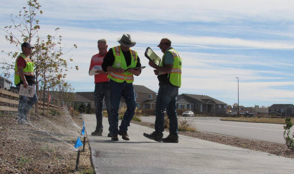
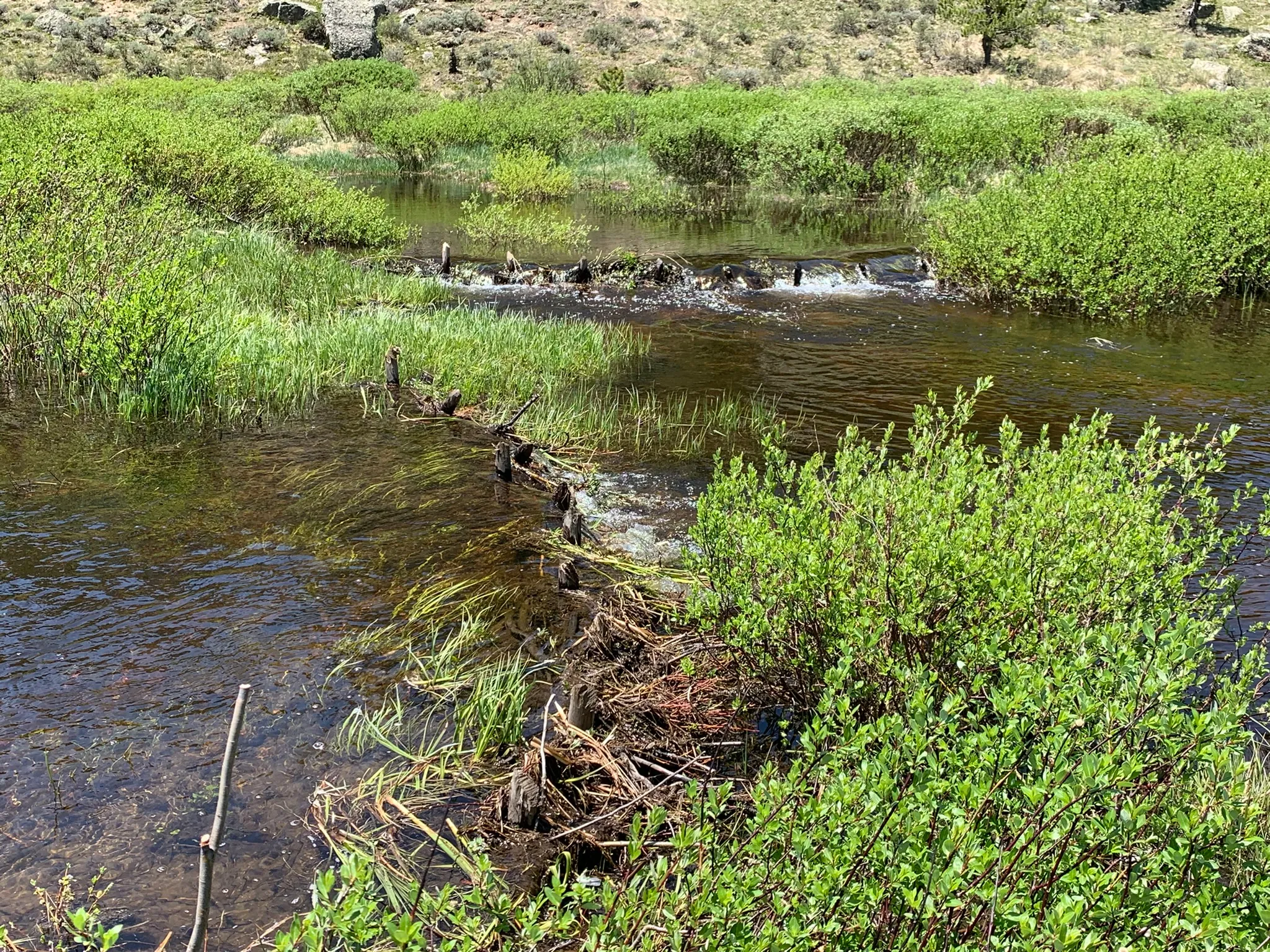
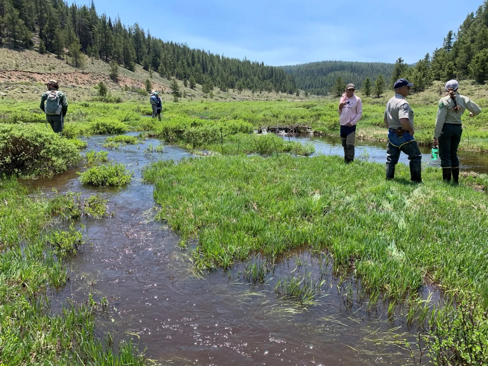
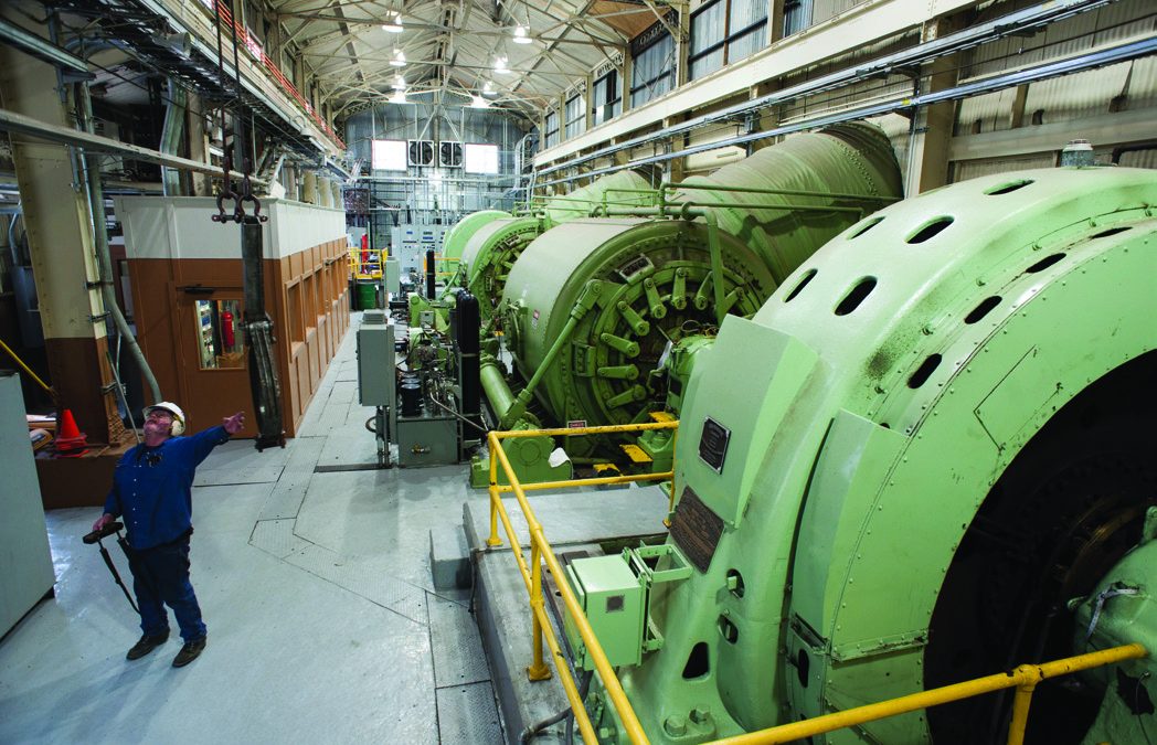
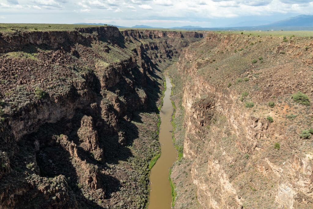

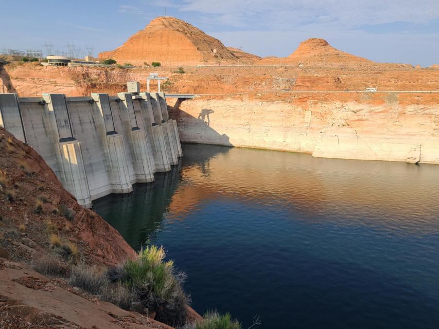

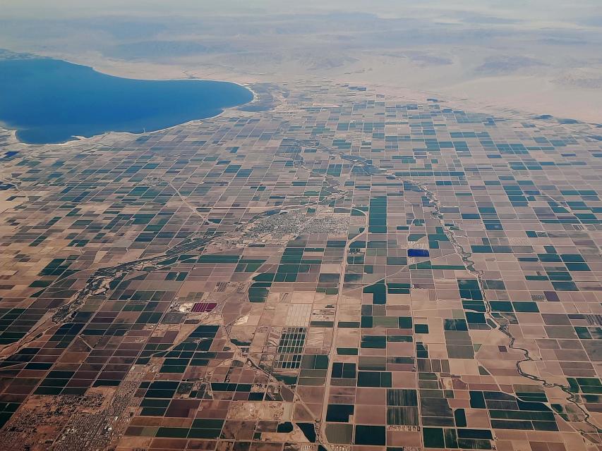

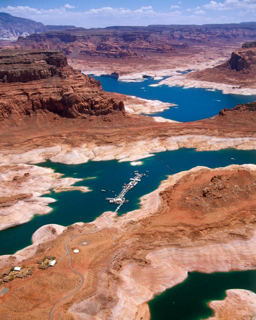


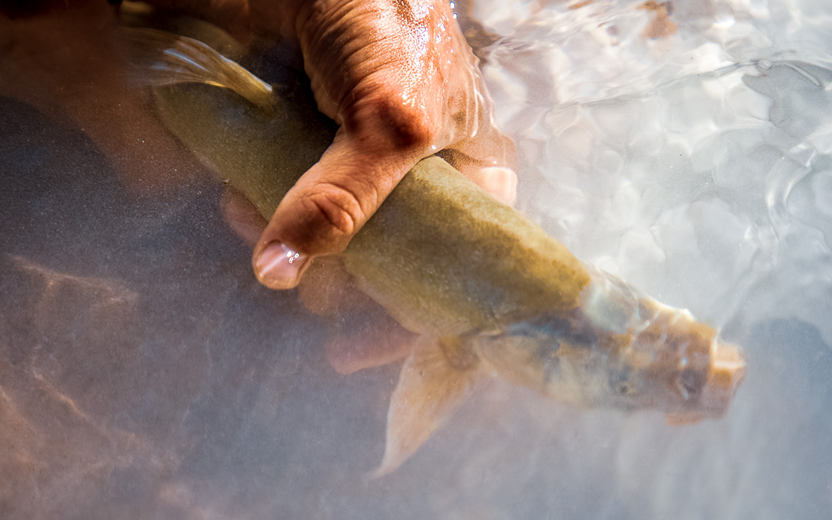

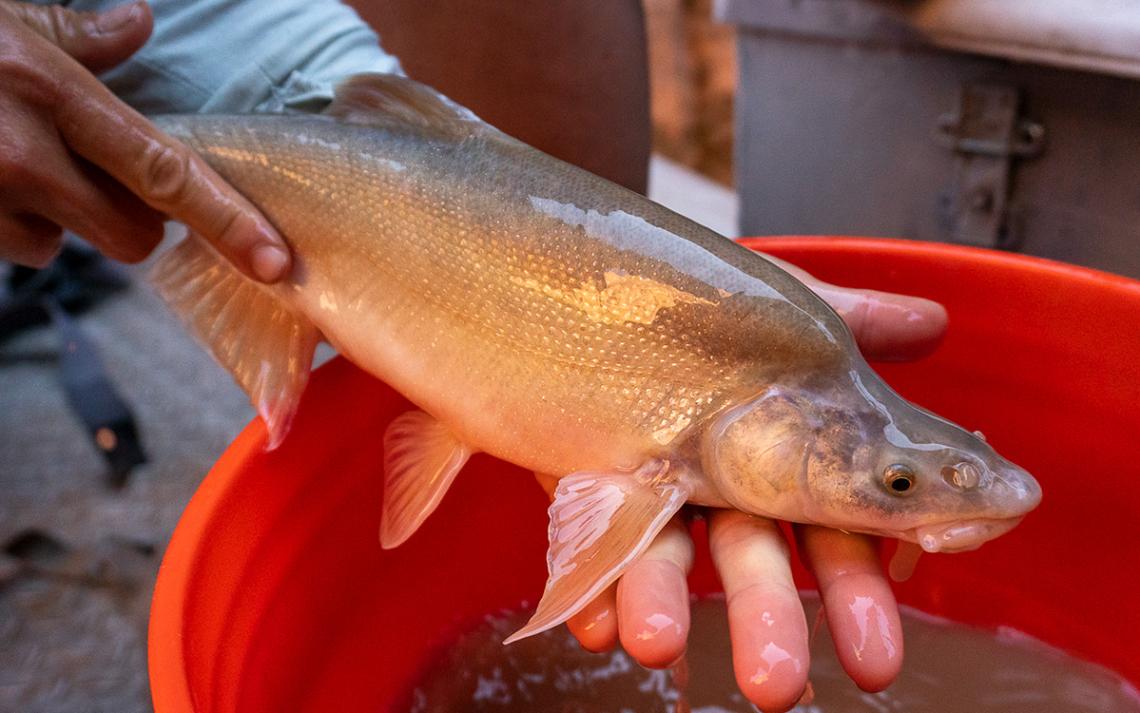

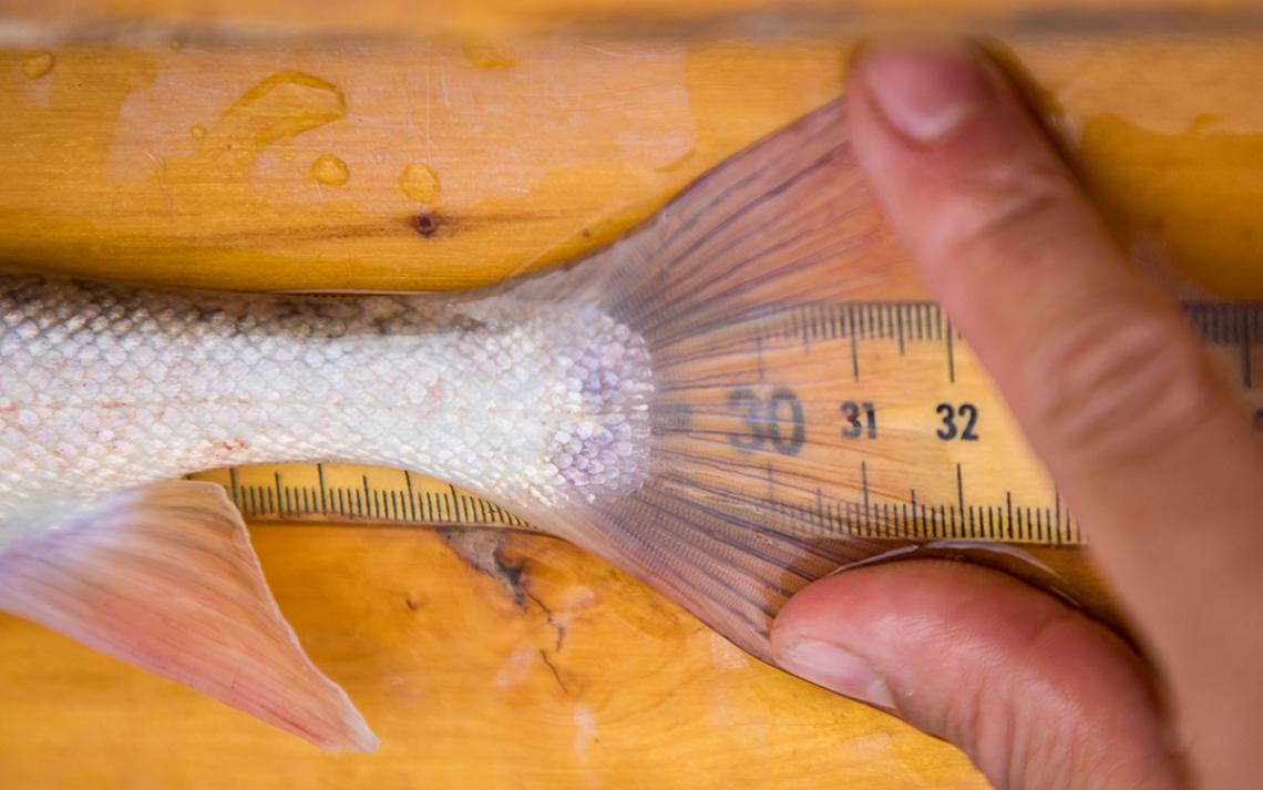
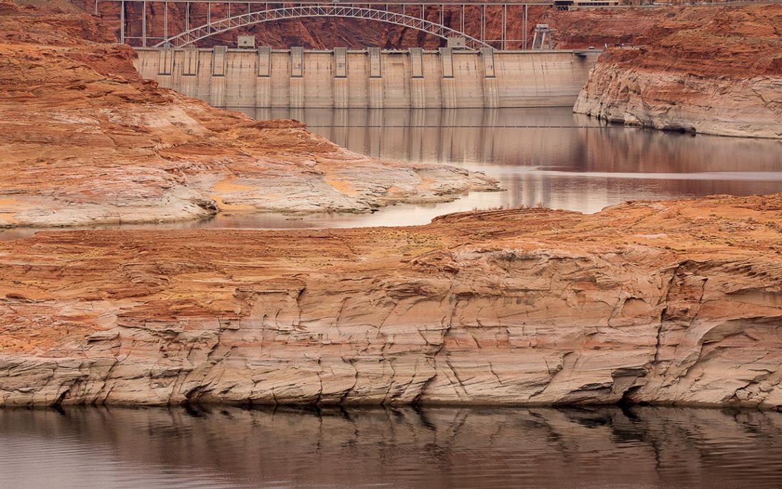
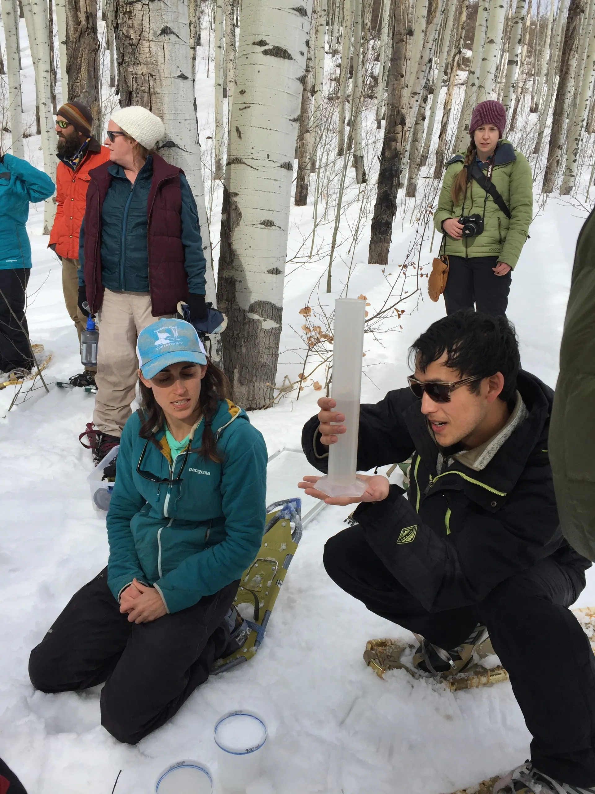
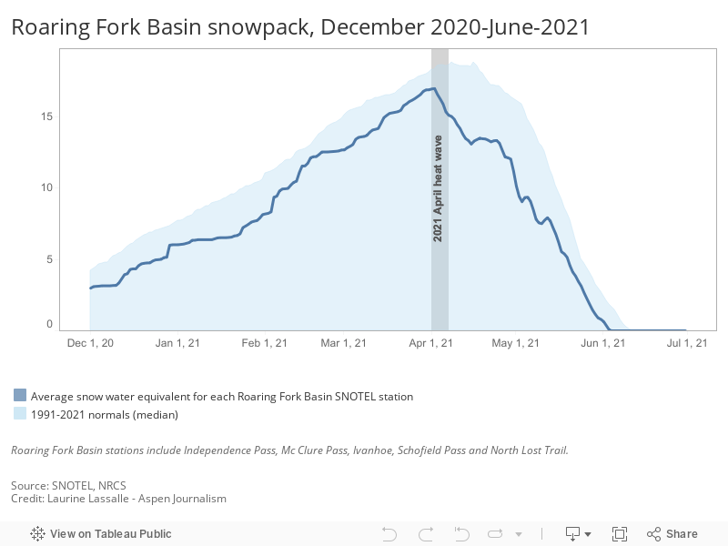
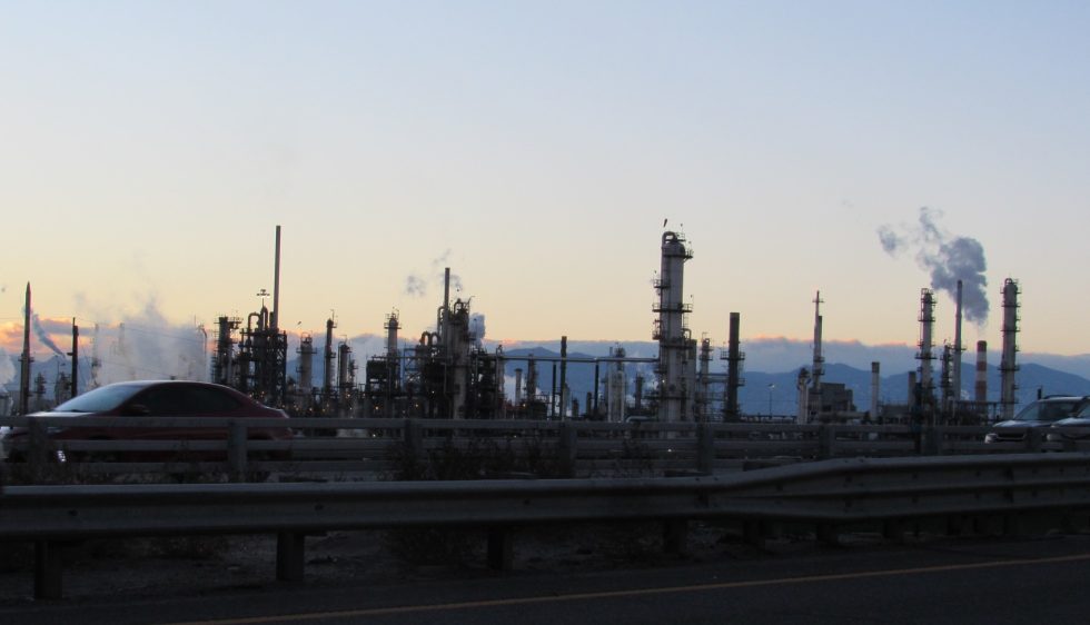
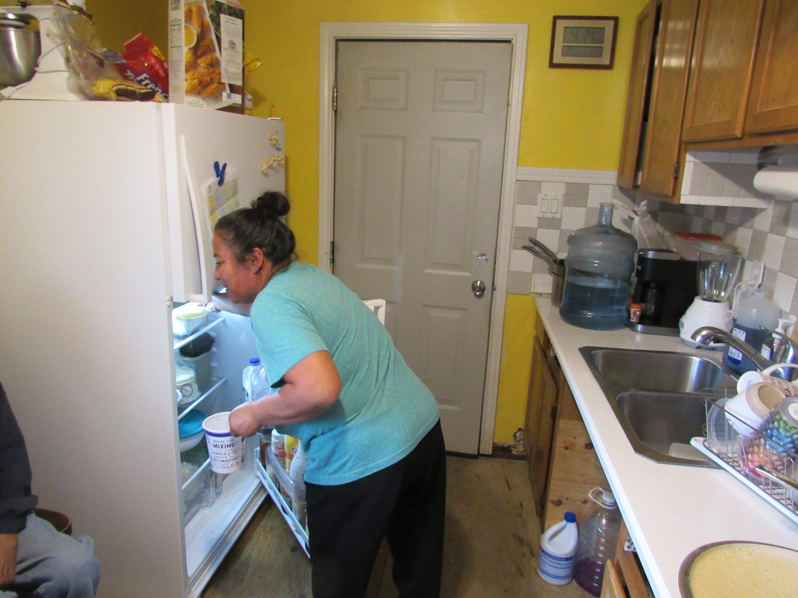
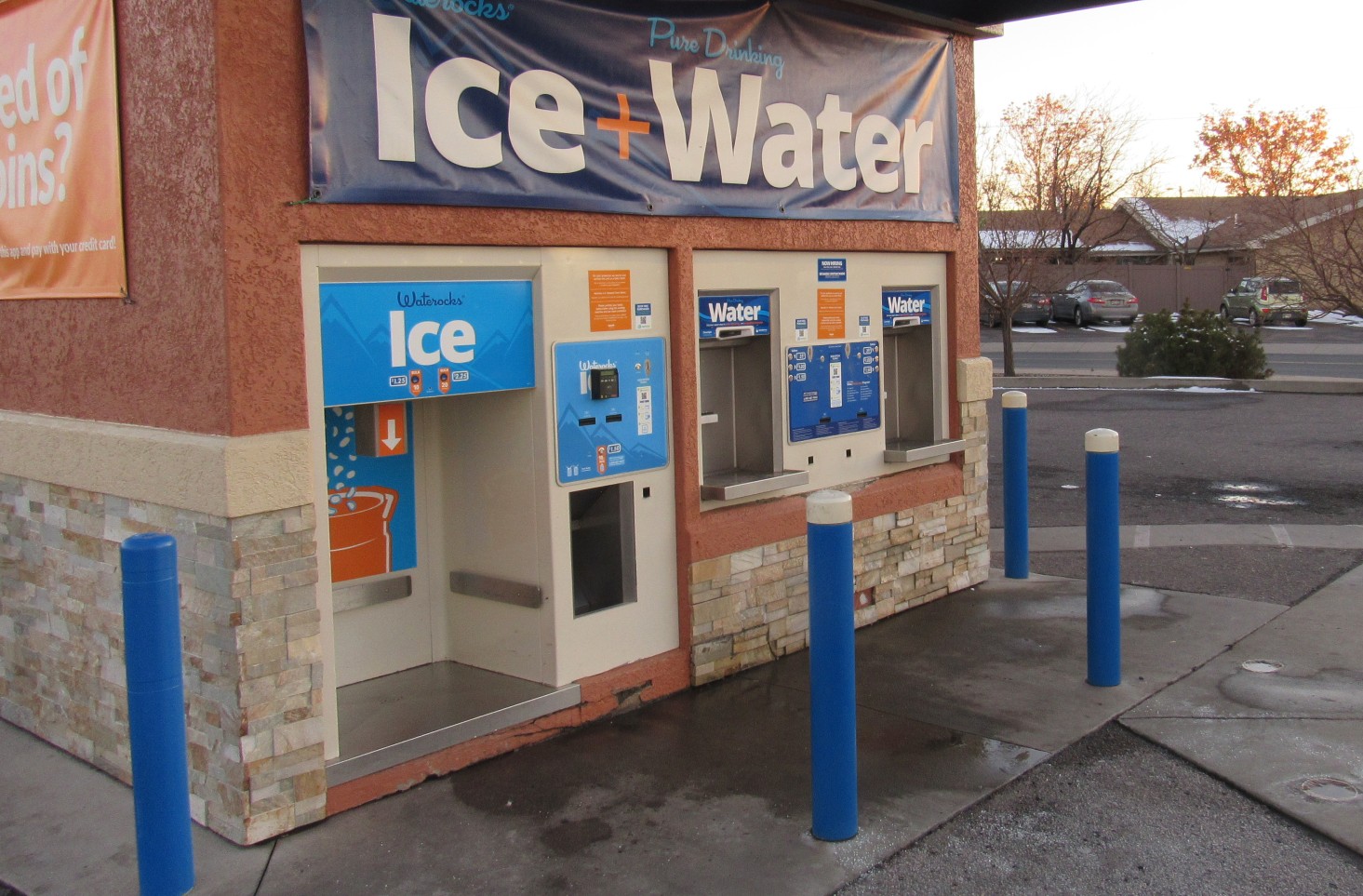
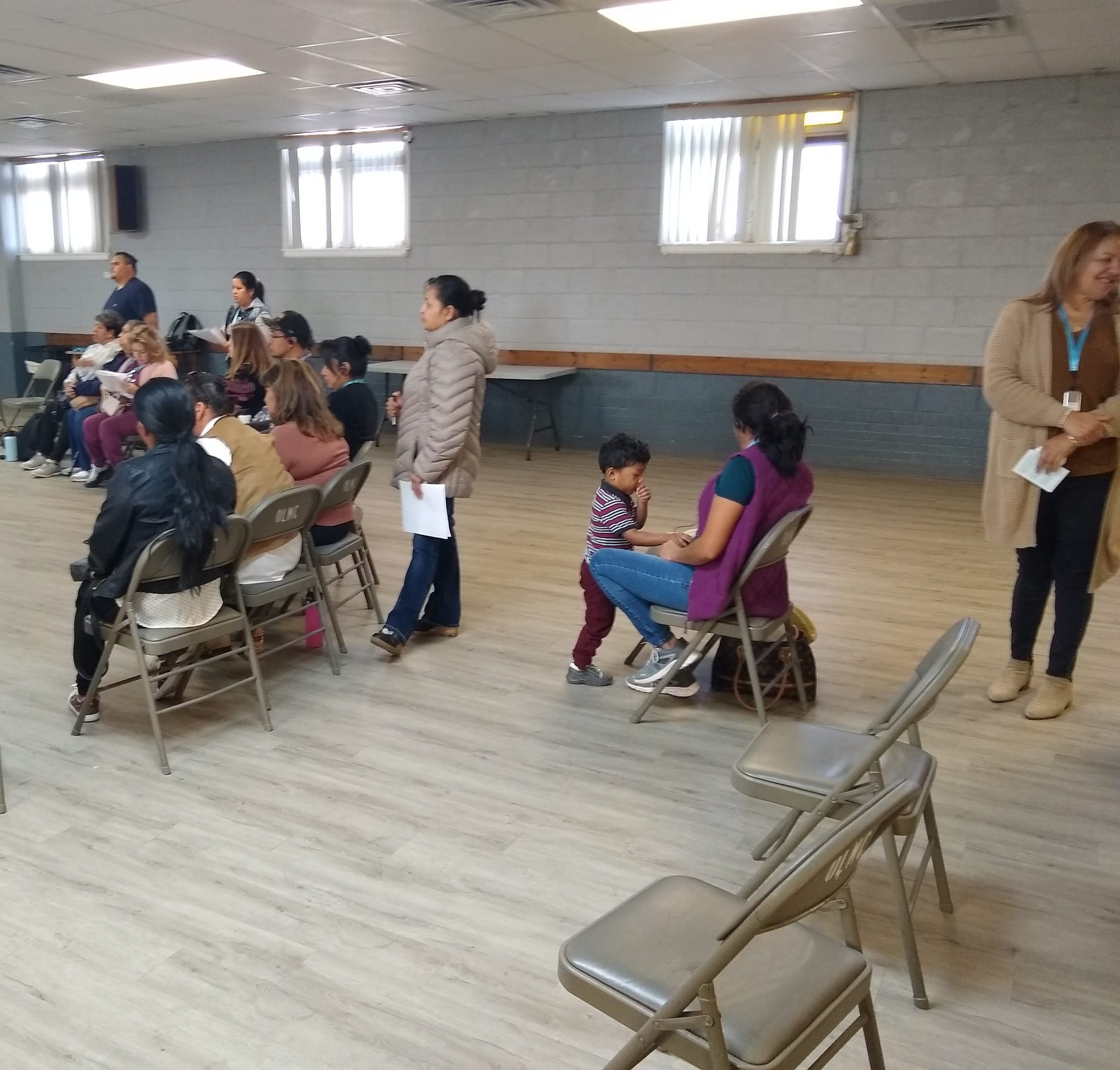

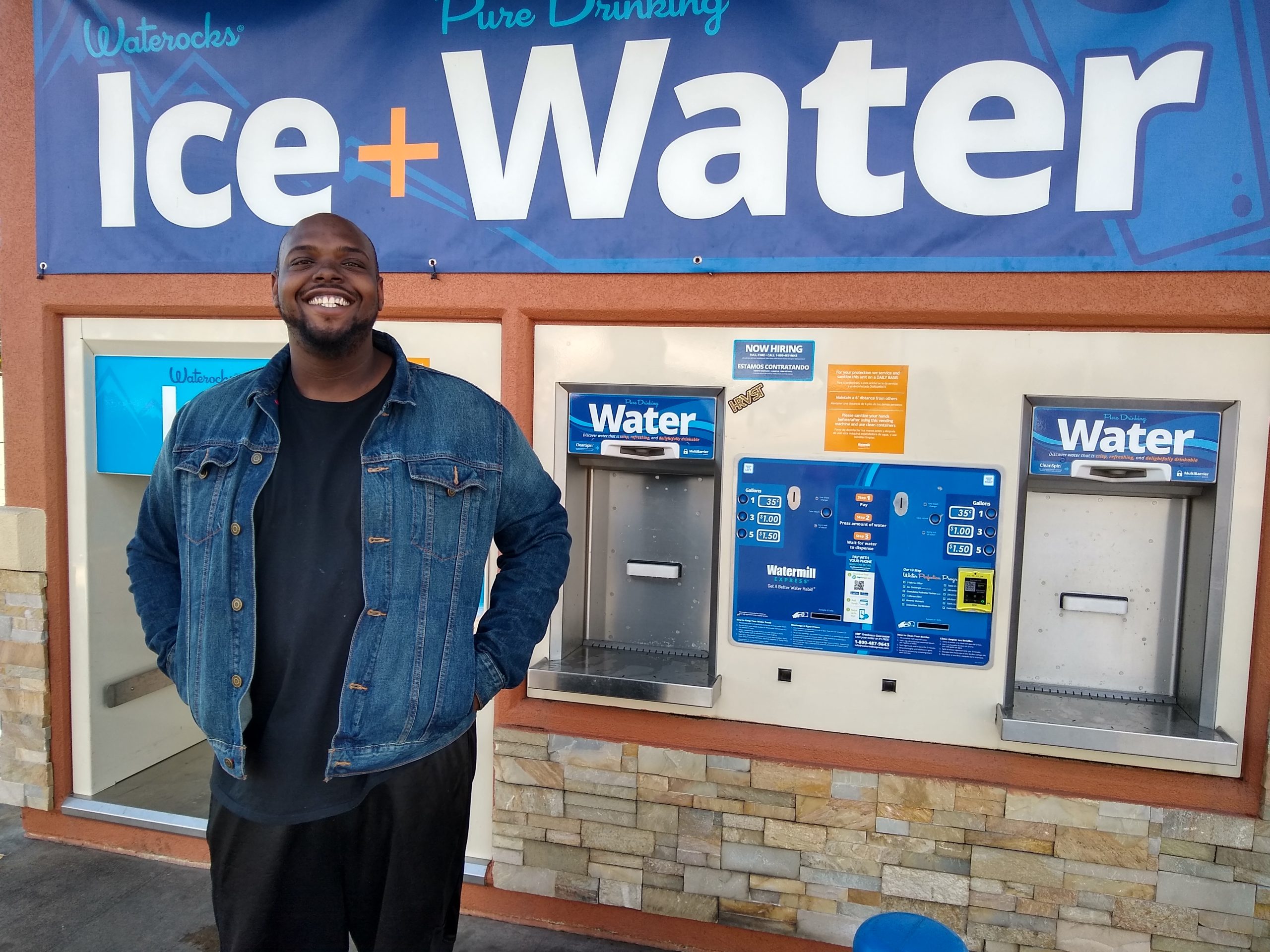
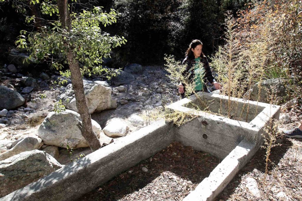


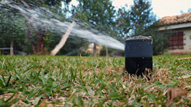


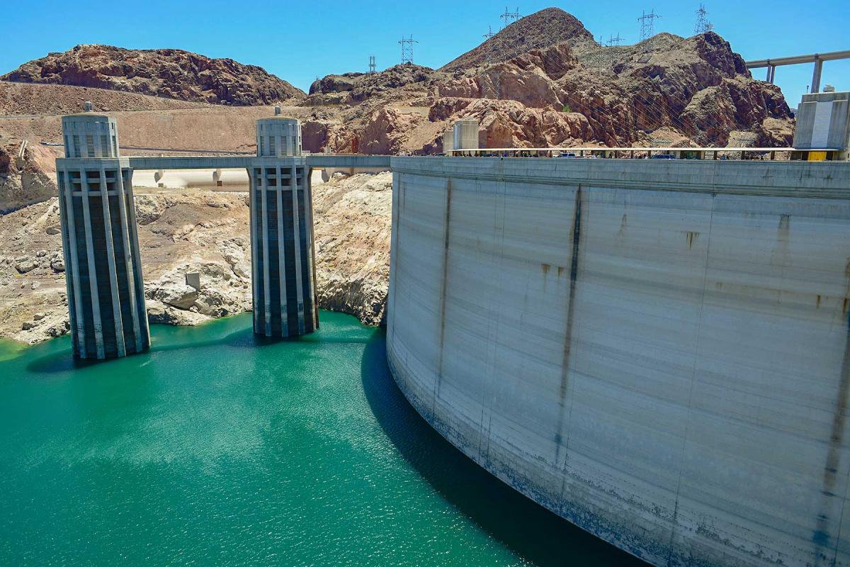
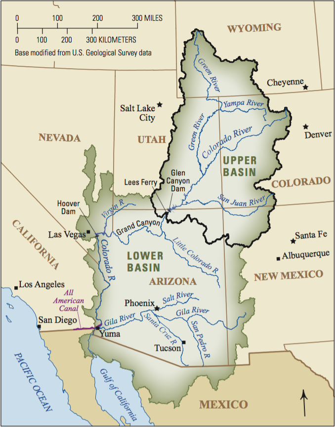