
By Sharon Udasin
Water Desk Grantee Publication
This story was supported by the Water Desk’s grants program.
May 14, 2021 — Editor’s note: This story is part of a collaboration, Tapped Out: Power, justice and water in the West, in which eight Institute for Nonprofit News newsrooms — California Health Report and High Country News; SJV Water and the Center for Collaborative Investigative Journalism; Circle of Blue; Columbia Insight; Ensia; and New Mexico In Depth — spent more than three months reporting on water issues in the Western U.S. The result documents serious concerns including contamination, excessive groundwater pumping and environmental inequity — as well as solutions to the problems. It was made possible by a grant from The Water Desk, with support from Ensia and INN’s Amplify News Project.
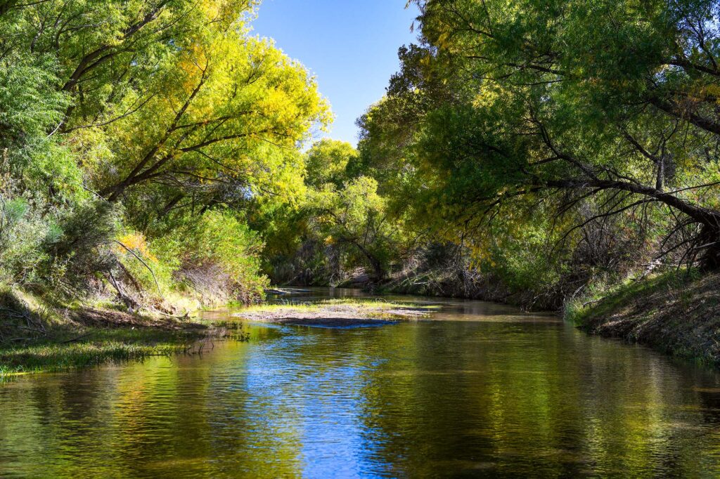
A riverbed that has been parched since the end of the 19th century — a portion of the historic lifeblood of the Gila River Indian Community — is now coursing again with water, luring things like cattails and birds back to its shores.
“You add water and stuff just immediately starts coming back naturally. Birds have returned and it’s just such a different experience,” says Jason Hauter, an attorney and a Community member. “It’s amazing how much has returned.”
The revival of this small segment of the 649-mile (1045-kilometer) Gila River, which has served the tribes that make up the Gila River Indian Community — the Akimel O’odham (Pima) and the Pee-Posh (Maricopa) — for roughly 2,000 years, was an added benefit of a grassroots infrastructure overhaul, known as “managed aquifer recharge,” or MAR, which aimed to restore the local groundwater basin. The MAR project has not only secured a water supply for local agriculture, but it has also generated a stable source of income and strengthened the Community’s ties to tradition.
“The land started to heal itself, reinvigorate itself,” says Governor Stephen Roe Lewis, who recently began his third term as leader of the Gila River Indian Community.
Hauter credits Lewis and his colleagues for ensuring that Community members have long-term access to their own resources while helping solve broader water supply problems in the region through innovative partnerships and exchanges with neighbors.
“They are very thoughtful about future generations, but they also recognize they live in this larger community and that you have to collaborate,” Hauter says. “Encouraging your neighbors to have good water practices, but also helping your neighbors, is good water policy.”
A Particularly Longstanding Claim to Water Rights
The ins and outs of water management and usage in the U.S. West are complex. In a region where every drop is important, questions about water — such as who gets what, how it’s moved from one place to another, and who pays for it — are vital to communities’ capacity to survive and thrive. These decisions are often based on century-plus-old legal doctrines that don’t always fit neatly into a modern, warming world — or address longstanding disregard for Native American tribal nations’ rights.
Western U.S. states adhere to legal doctrines called “prior appropriation” — sometimes referred to as “first in time, first in right” — linked to the mid-19th century Gold Rush and the Homestead Act, through which miners and farmers were able to claim and divert water sources for “beneficial use” — defined by activities such as irrigation, industry, power production and domestic use. A 1908 Supreme Court case ruled that the federal decision to establish Native American reservations inherently meant there would be sufficient water for those reservations. The priority date for water rights on these reservations therefore had to match the date of establishment, meaning that many tribal nations’ water rights took precedence over those of most existing users. During the past few decades, these nations have largely opted for settlements with the relevant federal, state and private bodies, rather than entering extensive and costly litigation to recover their water rights.
These settlements allow tribal nations to take part in the competitive markets that have long ruled water in the West. These markets involve things like selling water rights, getting money for helping mitigate drought and accruing “credit” from the Arizona Water Banking Authority by storing water in underground basins administered by the Arizona Department of Water Resources.
One such pivotal settlement came in 2004: To resolve tribal water rights claims, Congress passed the Arizona Water Settlement Act, which allocates a set amount of water each year to the Gila River Indian Community, drawing that water budget from a variety of sources in Arizona. The Community had a particularly longstanding claim to water rights due to its two-millennia history of farming, curtailed when miners and white settlers began diverting water following the Civil War. The governor’s late father, Rodney Lewis, devoted his career as Gila River Tribal Attorney to fighting for a just water settlement.
“It was the theft of our water, so this was a generational historic struggle to regain our water,” Lewis says. “We were and we still are historically agriculturalists, farmers. Our lineage, our ancestors were the Huhugam. And the Huhugam civilization had pretty much cultivated the modern-day Phoenix area in central Arizona.”
“They were master builders,” he adds, referring to complex water systems and canals that he says rivaled those of the Nile Valley.
As more and more nations regain control of their water resources, they are securing a critical provision for the long-term financial prosperity of their people and protection of their lands.
Mutually Beneficial Partnerships
As often occurs in tribal water rights settlements, the 2004 agreement served to restore the Gila River Indian Community’s claims to the river and its tributaries without displacing the descendants “of those who committed the original sin,” says Hauter, a partner at the law firm Akin Gump Strauss Hauer & Feld, which currently serves as outside counsel for the Community.
Toward that end, Hauter says, “really, what’s provided is an alternative supply.”
That alternative supply comes from the Central Arizona Project (CAP), an infrastructural behemoth that conveys about 1.5 million acre-feet (1.85 billion cubic meters; one acre-foot is about 326,000 gallons) of water from the Colorado River to central and southern Arizona each year. Serving as the single largest renewable water supply for the state of Arizona, the 336-mile (540-kilometer) system was authorized by then-President Lyndon B. Johnson in 1968, soon after which construction by the Bureau of Reclamation began. Three years later, the Central Arizona Water Conservation District — a multi-county water district — formed to repay the federal government for the project’s costs and oversee regional water supply.
Through the 2004 settlement, the Gila River Indian Community has the single largest CAP entitlement — bigger than that of the city of Phoenix — at 311,800 acre-feet (385 million cubic meters), Hauter explains. Finding mutual benefit in helping quench the thirst of the surrounding region, the Community entered into various water exchanges and leases that delivered about 60,000 acre-feet (74 million cubic meters) to Phoenix and other municipalities annually and left about 250,000-acre-feet (308 million cubic meters) for its own purposes, according to Hauter.
But this sudden surplus from the CAP actually posed a problem.
Pumping water from the project, Community members understood, would eventually become prohibitive due to water transport and associated electricity costs. The Lower Colorado River Basin Development Fund, managed by the U.S. Department of Interior, covers the Fixed OM&R (operation, maintenance and replacement) for certain Arizona tribes with settlements, but funding is only projected to last until 2045, Hauter explains.
The Community was using only about 50,000 acre-feet (62 million cubic meters) for irrigation purposes, leaving about 200,000-acre-feet (247 million cubic meters) unused, Hauter says. Because any unused CAP water can be remarketed by the state, Arizonans began counting on the Community to not use its full share.
With the legal guidance of Hauter and his team, the Community launched a strategic venture to store, share and sell much more of its CAP water in 2010.
The first such partnership occurred with former water supply rival the Salt River Project, the name of the utilities responsible for providing most of Phoenix’s water and power. Had the Community decided to enter litigation to recover its water rights, rather than settling, the Salt River Project could have faced enormous supply losses.
But the former rivals instead became partners, after identifying that the Salt River Project’s underground storage facility (USF), the Granite Reef Underground Storage Project, was an ideal place to store a portion of the CAP allocation the Gila River Indian Community was not currently using. The partnership has enabled the Salt River Project to withdraw water from storage — while maintaining a “safe yield,” or making sure any water that is taken from aquifers is replenished. In return, the Community has gained long-term storage credit, Hauter explains. Such storage credit enables the holder to bank CAP water and, when necessary, recover the water for future use.
The Community also stores water in groundwater savings facilities (GSF), including one operated by the Salt River Project and another south of the Gila River operated by the Maricopa Stanfield Drainage District. While a USF physically stores water in the aquifer through direct recharge, a GSF is an “indirect” recharge facility that uses CAP water instead of pumping local groundwater.
In what Hauter described as an “in lieu” agreement, the Community provides the operators of these GSF facilities with a renewable water supply — another portion of its CAP allocation — and so reduces the Salt River Project and Maricopa District’s need to extract groundwater. In return, the Community gets storage credit for the water that can remain in the ground.
“Everything We Needed Was at the River”
While these external collaborations bolstered the resilience of the Community, as well as that of the arid surrounding region, Gila River residents only really saw the revival of their long-lost local waterway when Community leaders launched a homegrown storage initiative. Recognizing the value in keeping some unused CAP resources at home, they chose to establish a network of managed aquifer recharge (MAR) sites. This type of underground storage allows for the free flow of water from a naturally permeable area, such as a streambed, into an aquifer, as opposed to “constructed recharge” sites that involve injecting water into percolation basins by means of a constructed device.
In order to implement these plans, the Gila River Indian Community came to an agreement with Arizona to acquire state regulatory permits for the MAR projects, despite the fact that tribal nations have sovereign control over water management. As a result of this decision, the Community has been able to market long-term storage credits in a sort of environmentally friendly banking system that allows more groundwater to stay in the ground.
“They realized they could get multiple benefits from deciding to have their project permitted per the Arizona regulations,” says Sharon Megdal, director of The University of Arizona Water Resources Research Center.
“They voluntarily chose to abide by the regulations for storage and recovery and therefore come under the whole credit accrual and accounting system,” she continues, stressing that not only can credits be used to recover water when needed in the future, but they can also be purchased by outside entities, which creates a revenue stream for the Community. “That’s really exciting.”
Three MAR facilities are already operating on the reservation today: MAR-5, the Olberg Dam underground storage facility, permitted in 2018; MAR-1B, the Cholla Mountain underground storage facility, permitted in 2020; and MAR-6B, a western and downstream expansion of MAR-5, which came online a few months ago. Construction of MAR-8, located downstream from MAR-5, will be complete in a few years, according to Hauter.
Hauter adds that it was only while planning the initial MAR-5 site that Community members envisioned the riparian restoration program that served “to recreate the river,” allowing cattails and other plants to blossom and enabling community members to create baskets and traditional medicines. Although the idea of restoring the river was secondary to the storage plans, Hauter says that its flow is intrinsic to the Community’s culture.
“The tangible benefit for most members is really having the river back to some degree,” Hauter adds. “It wasn’t something the settlement intended to accomplish, but the settlement gave the Community the tools to make it happen.”
Lewis and his father, who had already retired at the time, used those tools to see the first MAR site to fruition. The Lewises and their colleagues understood the benefit in adopting innovative methods for accumulating water at their future storage site.
“He truly saw the MAR-5 as a living testament to our historic tie to the Gila River,” the governor says, adding that his father considered the facility an opportunity to “return the flow of the river.”
With the revived river flow, the riparian habitat quickly began blossoming, including 50 documented species of birds within the first year of MAR-5’s operations, Lewis says. An interpretive trail now weaves through the once arid wetland, providing educational signposts and offering sacred cultural spaces for spiritual practice, Lewis explains. Elders are now taking advantage of the plants and silt available to engage in traditional basket weaving, medicine making and pottery, he adds.https://www.youtube.com/embed/z52k5NB02cM?feature=oembed
“They still remember the river sometimes flowing and the smell of the water,” Lewis says.
In recent years, before the opening of the MAR-5 site, the channel filled with water only in particularly wet seasons involving floods or heavy snowpack upstream, according to Lewis.
“Everything we needed was at the river,” he adds. “That was our lifeblood.”
Continuing to Plan For a Drought-Ridden Future
In conjunction with the opening of the MAR facilities, the Community cemented a pivotal agreement in 2019 with the Central Arizona Groundwater Replenishment District (CAGRD), a groundwater replenishment entity operated by the Central Arizona Water Conservation District. Through this agreement, CAGRD leases 18,185 acre-feet (22 million cubic meters) of the Community’s CAP water and stores the majority of that water in the MAR sites, while receiving long-term storage credits in return from the Arizona Water Banking Authority. Only if the MAR facilities are full is CAGRD allowed to store the leased water elsewhere, Hauter explains.
Alongside the MAR projects, the Community has also been rehabilitating existing wells and building new ones in order to create a backup supply for agricultural use when Gila River flow is minimal. Well water is less expensive than CAP water, since wells can recharge naturally during storms — so much so that such events collectively add at least 100,000 acre-feet (123 million cubic meters) to the Community’s annual water supply, according to Hauter. The Community took additional steps to reroute its CAP supplies after the federal government and the seven Colorado River Basin States implemented their drought contingency plans, meant to elevate water levels in Lake Mead, in 2020. As part of that regional effort, Hauter explains, the Community is providing a total of at least 200,000 acre-feet (247 million cubic meters) of water to be stored in Lake Mead from 2020 to 2026, when the drought contingency plans expire. For its contribution, the Community gets money through the Arizona Water Bank and the Bureau of Reclamation.
Only through the Community’s creative collaborations and homegrown projects has so much of its CAP entitlement been able to help replenish Lake Mead, Hauter says. Today, the Community has reduced its CAP water usage for irrigation to 15,000 acre-feet (19 million cubic meters) per year, while its CAP water storage capacity in the MAR projects is up to about 40,000 acre-feet (49 million cubic meters) per year. After construction of MAR-8 is complete, total CAP water use for storage and irrigation will reach about 75,000 acre-feet (93 million cubic meters), Hauter says.
As the Community’s leaders continue to plan for a drought-ridden future, they are evaluating whether it will be necessary to use more of its CAP allocation for their own needs. At the moment, much of the reservation’s agriculture involves water-intensive crops like alfalfa, feed corn and cotton. An overhaul of the farming infrastructure, according to Hauter, would require “changing attitudes about how food is grown” and incorporating more efficient technologies, as well as encouraging farming among younger people.
Overall, Hauter says, “it’s an exciting future for the Community, and it will be interesting to see what happens in the next 20 or so years.”
Lewis is confident that the Community’s agricultural tradition will remain strong, particularly due to the younger generation’s concerns for social justice, equity and environmental issues.
“We want to provide opportunities for our community members to reengage in any way in our agricultural heritage,” he says. “We’ve always been innovators, going back to the Huhugam with their amazing engineering.”
In addition to the commercial company Gila River Farms, which is owned by the tribe and employs Community members, Lewis says that local family farms continue to thrive. Lewis also says that “there’s a big push” for young people to obtain degrees in agro-business, hydrology, water engineering and other relevant fields that will provide them with a livelihood while working for their Community — a place that has become even more special to them during the pandemic year.
“It’s a public health emergency that we’ve been going through,” Lewis adds. “But at the same time, I think this is an opportunity where you see a lot [of] our younger generation that are wanting to learn who it is to be from the Gila River Indian Community.”
“A Total Win-Win”
While the MAR projects and the larger water exchange deals serve to safeguard the Community’s water supplies, Hauter says he’s uncertain as to whether neighboring tribal nations could replicate this model. Other tribes, he explains, might have different agricultural interests or economic concerns, as well as varying geological and hydrological conditions.
In Megdal’s opinion, at least one aspect of the Community’s strategy could be replicable regardless of geography: the strategic accrual and marketing of long-term storage credits in permitted recharge facilities. The Gila River Indian Community has diversified its portfolio of storage credit and sales through “multiple vehicles,” she explains, including its MAR projects, the Salt River Project partnership, and its transfer of credits to CAGRD.
“They are able to meet their objectives including having riparian benefits and river benefits and sell the credits — because the credits are then recovered elsewhere. … For them, it’s like a total win-win,” Megdal says, adding that she considers the Community’s achievements to be “a bellwether project.”
Already, she says, the Tucson-region Tohono O’odham Nation has begun selling some credits to CAGRD. Acknowledging that the two cases involve varying geological and legislative circumstances, Megdal stresses that the Gila River Indian Community has demonstrated the benefits of the storage and credit accrual system.
“These long-term storage credits are the most marketable part of the water system,” Megdal says. “It’s an emerging market, and the Gila River Indian Community has emerged as a key leader in that market.”
“I see this example of a tribal nation entering voluntarily into an intergovernmental agreement with the state so that all the parties can develop these mutually beneficial exchanges or marketing transactions in a voluntary way,” she adds. “It’s really a notable innovation.”
Editor’s note: This story is also part of a four-part series — “Hotter, Drier, Smarter: Managing Western Water in a Changing Climate” — about innovative approaches to water management in the U.S. West and Western tribal nations. The series is supported by a grant from the Water Desk at the University of Colorado Boulder and is included in our nearly year-long reporting project, “Troubled Waters,” which is supported by funding from the Park Foundation and Water Foundation. You can find the other stories in the series, along with more drinking water reporting, here.
The Water Desk’s mission is to increase the volume, depth and power of journalism connected to Western water issues. We’re an initiative of the Center for Environmental Journalism at the University of Colorado Boulder. The Water Desk launched in April 2019


