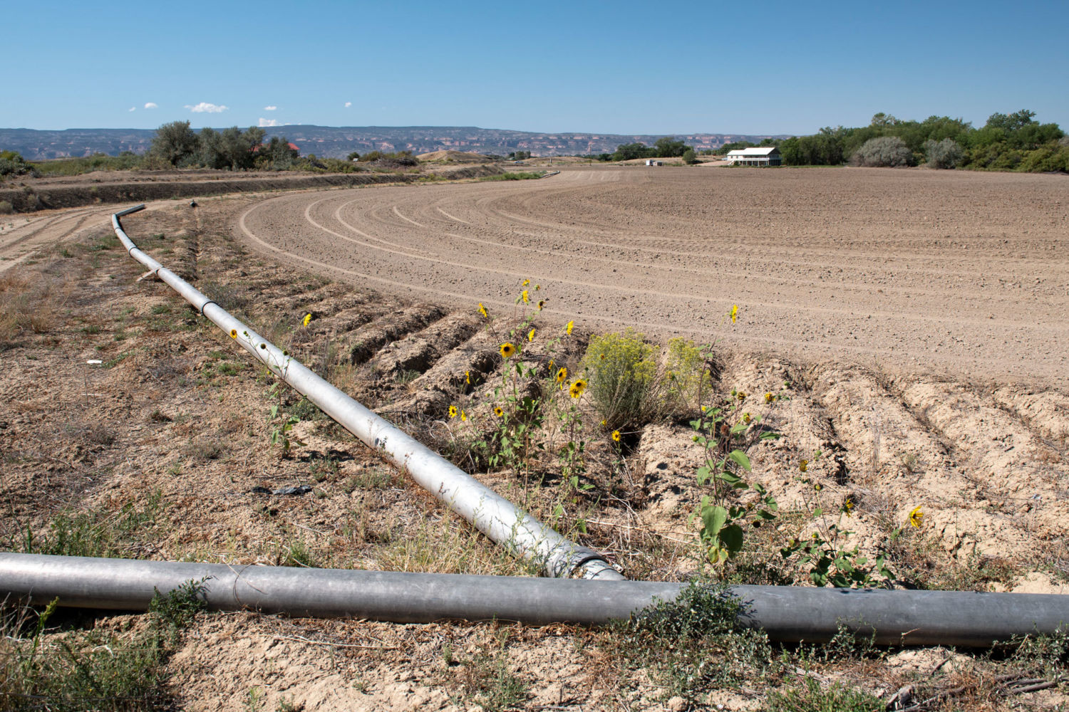
Steamboat Springs, Colorado: Hundreds of ranchers in the scenic Yampa Valley have ignored a state request to begin measuring the water they use, putting them on a collision course with regulators that will land many of them in court this summer if they don’t relent.
Division Engineer Erin Light, the top water chief in the region, said roughly 70 percent of irrigators in this remote part of northwestern Colorado have not installed measuring devices, meaning that millions of gallons of water are being consumed without oversight, something that is routine on other river systems.
“I sent out a notice in March saying, ‘I’m going to issue an order if you don’t install them now,’” she said. “It was a friendly gesture.”
No one responded.
“We have not been impressed with the response,” Light said.
On Sept. 30, she issued a formal order to 550 ranchers, which, if ignored, could result in fines of up to $500 a day and court action.
The deadline to respond this time was Nov. 30. Few did so, Light said.
Under the terms of the order, ranchers who don’t install measuring flumes or other devices to track diversion rates from the river into their irrigation systems will be cut off if they try to irrigate in the spring. They will also likely face prosecution, Light said.
“We’ll be working with the attorney general’s office to begin court proceedings,” she said.
The issue reflects an end to a gentleman’s agreement that dates back to the late 1800s, a consensus that said these tough, resourceful ranchers could manage their own water, that the state did not need to issue a direct order, and that the hay meadows, and cattle and sheep operations, could continue diverting their irrigation water as they always had.
And that’s largely because of the Yampa River’s amazing flows. Unlike almost any other place in Colorado and the West, water here was once so abundant that there was almost always plenty to go around. Measurements weren’t needed, and the state rarely had to step in to resolve disputes among water users, allowing Mother Nature free rein.
But chronic drought, climate change, and population demands have begun eroding the Yampa’s once bountiful supplies. For the first time ever, in the desperately dry summer of 2018, Light was forced to step in, cutting off some irrigators because more senior water rights holders weren’t getting their legal share of water. That sent a shock across the valley but triggered little action.
These days the Yampa River has the distinction of being the only one of Colorado’s eight major river basins that remains largely unmeasured and unregulated.
But Light said the issue has become too critical, and water too scarce, to allow that to continue.
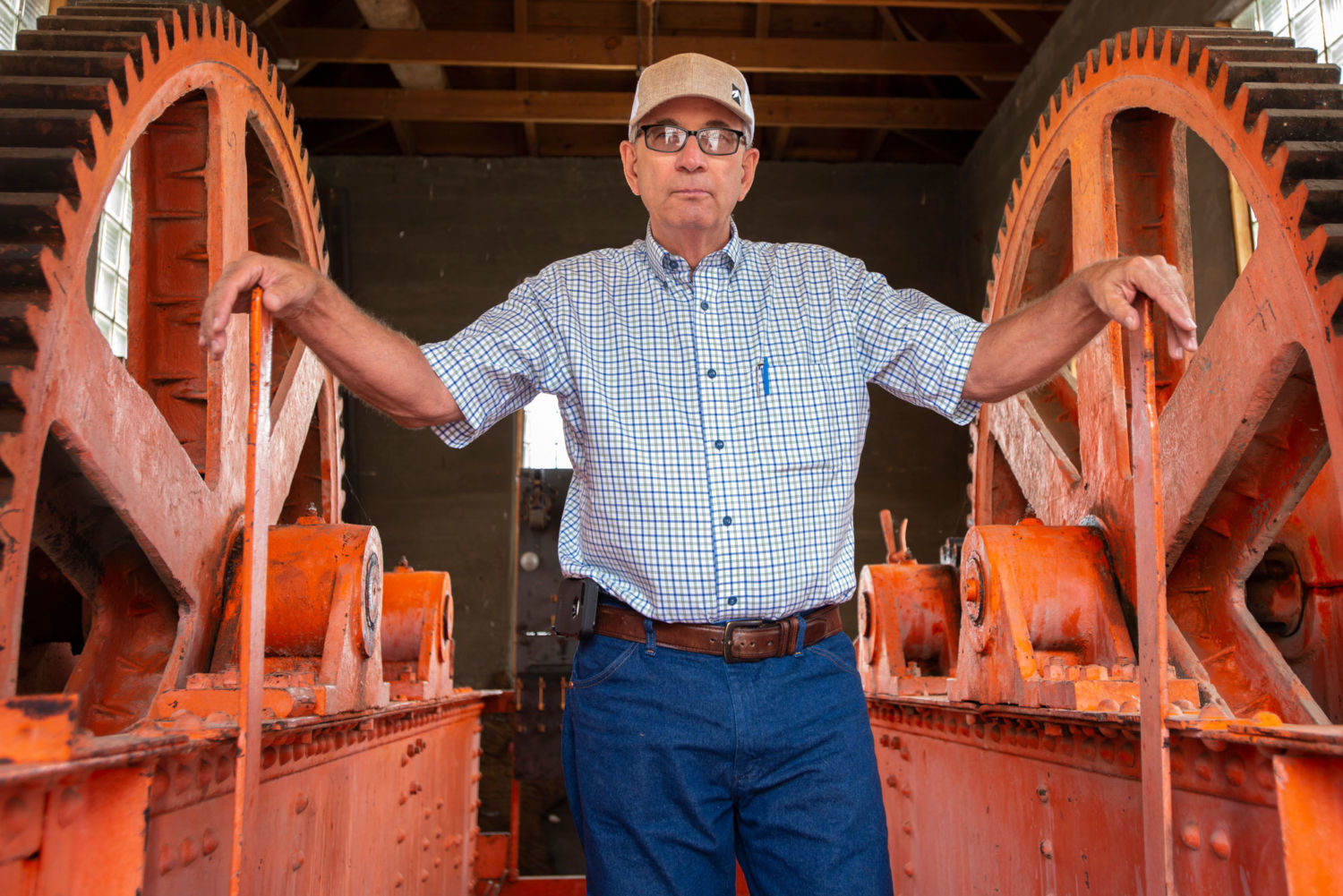
Mike Camblin, whose family has been ranching here for more than 100 years, said he will comply with the order. But he and many of his colleagues feel the state has been too heavy handed in its approach.
“What I don’t like about the order is that it’s forcing people to install those or they are going to get fined $500 a day to run water even if it’s a free river,” he said. The term free river means that there is enough water in the stream to satisfy all water rights, and under normal circumstances people can divert as much of the excess as they want.
Not anymore.
“I’m very disappointed,” said Dave Seely, a long-time rancher who has 11 different irrigation ditches that span Moffat and Routt counties.
Many of his ditches already have measuring devices, but the order means he will have to install at least five new ones at a total cost of more than $10,000, he estimates.
Light is aware of the anger in the ranching community and said she understands the financial burden the order will place on many irrigators.
“I’ve been trying to encourage my water users to understand that there is a value to them in measuring how much water they divert. Water is often a rancher’s most valuable asset. But many don’t want to hear that,” she said.
Seely plans to comply with the order so that he can divert in the spring. But there is a lingering resentment and sense of loss for an era that is ending.
“Historically there was never a call on the river, but now there is,” Seely said. “Now we’re under the jurisdiction of the state engineer forever.”
Correction: An earlier version of this article incorrectly stated that it was illegal to divert water at this time. It will be illegal in the Spring if measuring devices have not been installed.
Jerd Smith is editor of Fresh Water News. She can be reached at 720-398-6474, via email at jerd@wateredco.org or @jerd_smith.
This story originally appeared on Fresh Water News, an independent, non-partisan news initiative of Water Education Colorado. WEco is funded by multiple donors. Its editorial policy and donor list can be viewed at wateredco.org.
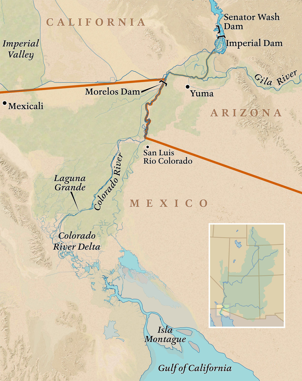
The Colorado River has been dammed, diverted, and slowed by reservoirs, strangling the life out of a once-thriving ecosystem. But in the U.S. and Mexico, efforts are underway to revive sections of the river and restore vital riparian habitat for native plants, fish, and wildlife.
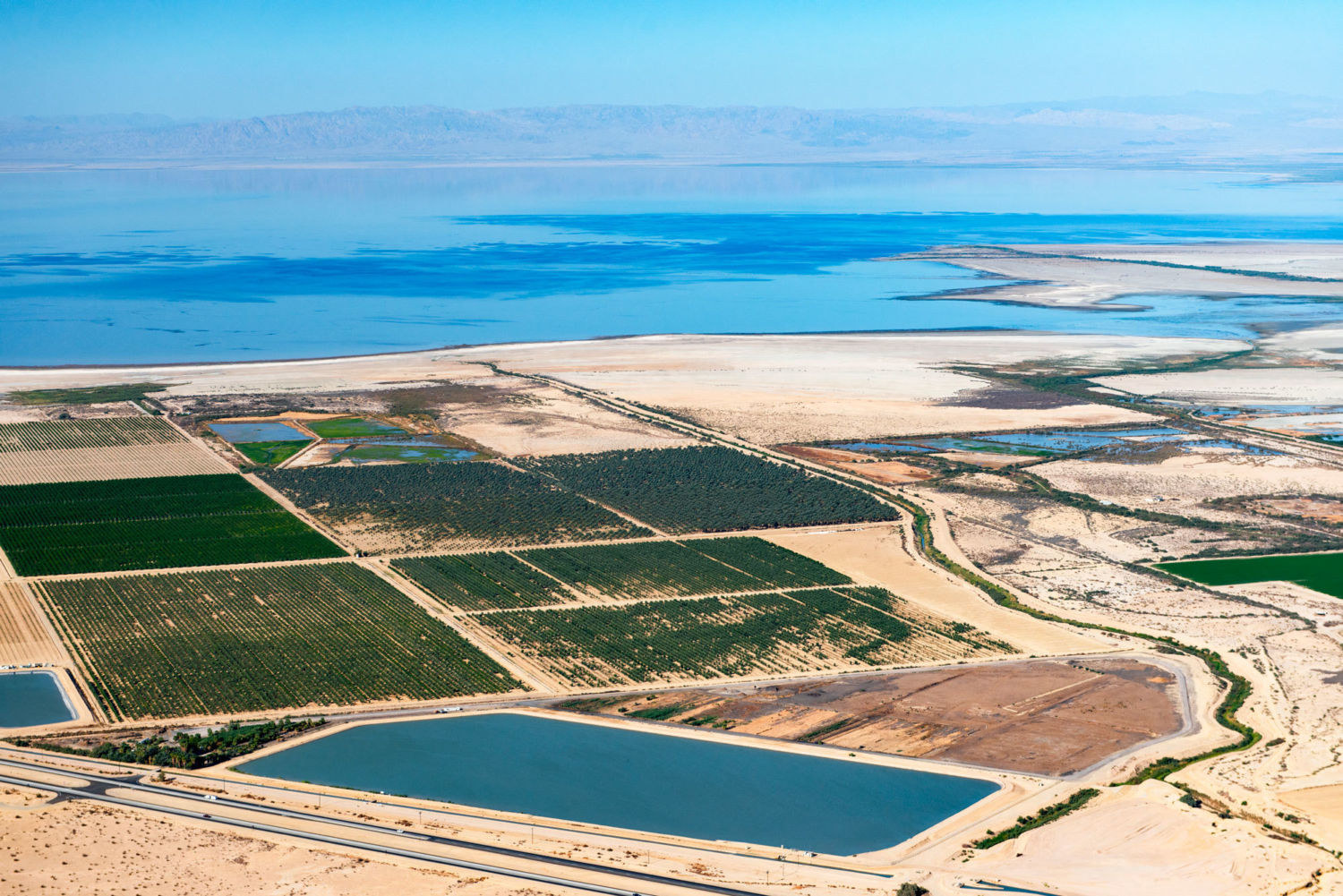
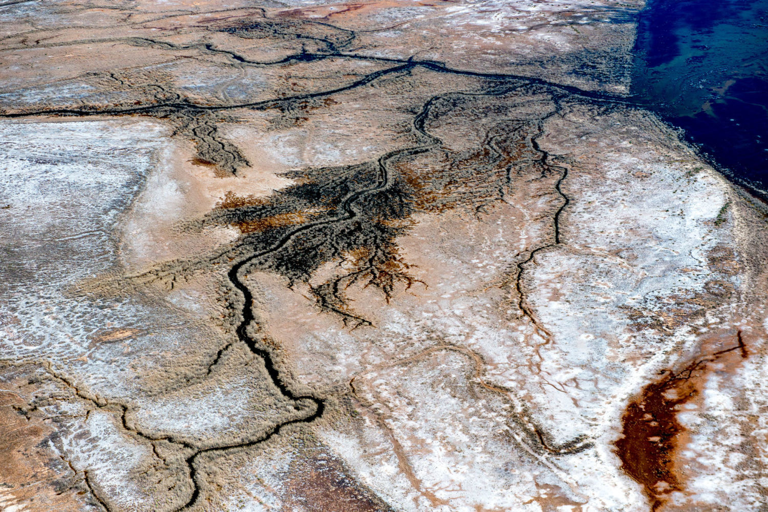
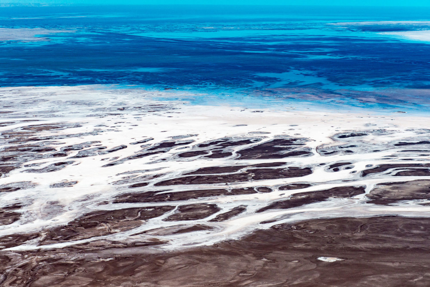
The Colorado River delta in Baja California is a mosaic of old river channels, tidal salt flats, and runoff from agricultural fields to the north. PHOTO BY TED WOOD
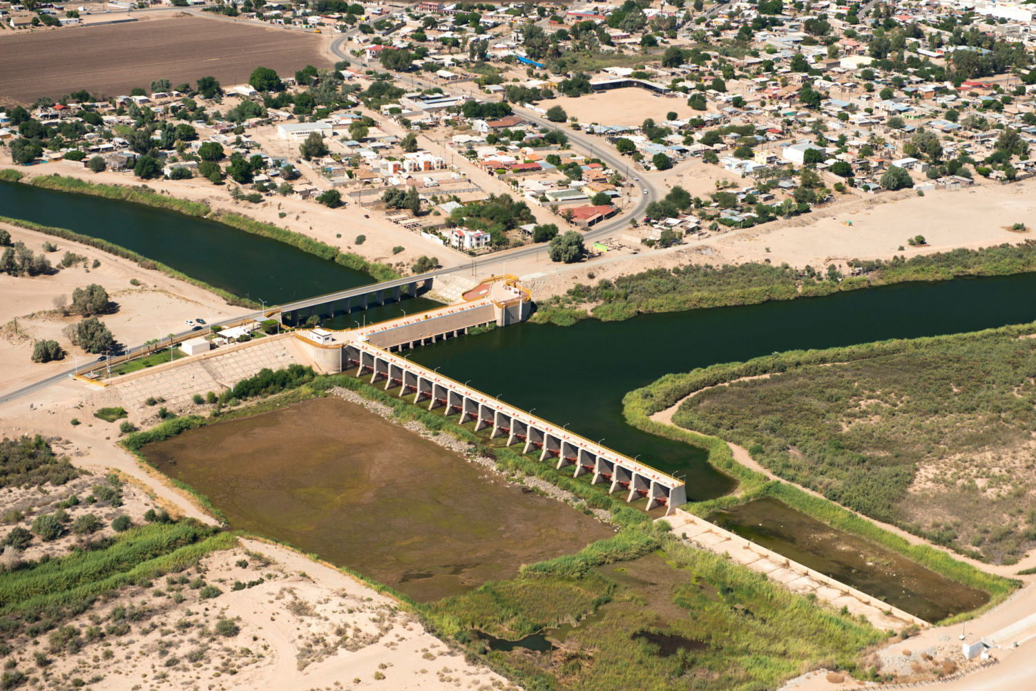
From the air, the last gasp of the Colorado River is sudden and dramatic. The pale green river flows smack into the Morelos Dam on the U.S.-Mexico border, and virtually all of it is immediately diverted into a large irrigation canal that waters a mosaic of hundreds of fields — alfalfa, asparagus, lettuce, and other vegetables, their vivid green color clashing against the sere desert. The slender thread of water that remains in the Colorado’s channel continues to flow south, but is soon swallowed up by a sea of sand, far short of its delta, which lies 100 miles farther on.
The Colorado River once surged through the delta during high flows, carrying so much water at times that shallow draft steamboats chugged hundreds of miles up the river into the U.S. with loads of freight. The water in the delta nourished a vast fertile landscape, a fitting end to a river known as the Nile of North America.
“The river was everywhere and nowhere,” the naturalist Aldo Leopold wrote during a 1922 canoe trip to the delta, describing the waterway as it ebbed, flowed, braided, and stalled into pools, nourishing a rich and diverse ecosystem of “a hundred green lagoons,” a “milk and honey wilderness” with thick stands of cottonwoods and willows that provided habitat for hundreds of species of birds. The delta’s marshes, mudflats, and white sand beaches were home to clapper rails, bitterns, mallards, teal, and clouds of egrets.
Bobcats, puma, deer, and wild boar wandered the delta’s forests. Leopold was searching for the jaguar that roamed there, but didn’t see any.
The Morelos Dam on the U.S.-Mexico border, where the Colorado’s remaining water, 1.5 million acre-feet, is diverted to cities and farms in Mexico. Below the dam, the original Colorado River channel is dry. PHOTO BY TED WOOD. SUPPORT FOR AERIAL PHOTOGRAPHS PROVIDED BY LIGHTHAWK
Myriad species of fish swam in the river and in the brackish waters of the Gulf of California, including a relative of the white sea bass, the totoaba, which grew as large as 300 pounds. They were the buffalo of the sea, pursued for their meat and so plentiful that a whole fish sold for a nickel. Fishermen caught 4 million pounds a year in the early 20th century. Also harvesting the bounty of the delta were the indigenous Cocopah, who threaded the waters in dugout canoes and lived in round houses made of reed and brush.
As a natural river, before it was dammed, the Colorado was a massive, dynamic waterway. It flowed from elevations above 14,000 feet in the Colorado Rockies, then dropped to sea level, which meant that it moved at high water with tremendous force, liquid sandpaper carving out red rock canyons. It flooded the desert plains, carving new channels and braids with every inundation. When it receded, it left behind a mosaic of fecund marshes, wetlands, and ponds.
In its natural state, the Colorado had more extreme flows than any river in the U.S., ranging from lows of 2,500 cubic feet per second in the winter to 100,000 cubic feet per second in the summer. In 1884, an all-time historical peak flow reached 384,000 cubic feet per second in Arizona.
But extreme flows are too capricious to support a civilization, so over the past century or so humans have built a network of expensive dams and reservoirs, pipelines, canals, flumes, and aqueducts to tame and divert the flow. Yet these projects also strangled the life out of a once-thriving ecosystem. By design, the river will never again function as a free-flowing stream.
Can the Colorado flourish — to some degree and in some places — with the permission of engineers?
Now, however, experts and environmentalists are rethinking this technological marvel of a river, and looking at ways a natural Colorado can flourish — to some degree, and in some places — with the permission of the engineers. One of those places is in the delta.
The water that flowed in the once-lush delta has been replaced by sand, and the cottonwoods and willows have surrendered their turf to widespread invasive salt cedar and arrowweed. Without the river and its load of nutrients, marine productivity in the Gulf of California — where the Colorado River once ended — has fallen by up to 95 percent. But despite the dismal forecast for the future of water on the Colorado, some conservationists are hoping to return at least a portion of the delta to its former glory.
Downstream from the Morelos Dam, the Colorado River delta now runs dry before reaching the Gulf of California. MAP BY DAVID LINDROTH for YALE ENVIRONMENT 360
“We are trying to restore a network of sites that creates a functional ecosystem,” said Francisco Zamora, who manages the project for the Sonoran Institute. “We’ve acquired water rights, but use them for habitat instead of cotton or wheat.”
The delta is one of a disconnected series of restoration projects that government agencies, local groups, and environmental organizations are undertaking along the Colorado. Numerous efforts are focused on tributaries to the main stem of the river, seeking to enhance resiliency by increasing the flow of water and protecting and restoring riparian habitat for fish and other wildlife.
For example, a coalition of groups — including state agencies, nonprofits, and the Arizona cities of Buckeye and Agua Fria — have been removing invasive salt cedar, planting native species, and building levees to reclaim a 17-mile stretch of the Gila River. Invasive salt cedars are a region-wide problem on the lower Colorado, with a single tree sucking up 300 gallons a day. The invasive forest on this stretch of the river uses enough water to serve 200,000 households.
In the upper basin, meanwhile, a number of groups and local landowners are working to restore a 15-mile-long floodplain with globally significant biodiversity on a narrow section of the Yampa River, another Colorado tributary. Called Morgan Bottom, the section has been damaged by deforestation and poor agricultural practices, threatening bald eagles and greater sand hill cranes, as well as a rare riparian forest of narrowleaf cottonwood and red osier dogwood.
But there are limits to how natural the Colorado River can become, especially along the river’s main stem. “We should not kid ourselves that we are making it natural again,” said John Fleck, the director of the University of New Mexico’s water resources program and the author of a book about the restoration of the Colorado. “We are creating an intensively managed system to mimic some nature because we value it.”
Because of the Colorado’s extensive infrastructure, serious disruption of the river’s ecology is inevitable.
Indeed, some of the remaining naturalness on the Colorado is, paradoxically, because of the human-made system. “The geography of the Colorado gives it hope because L.A. and southern California, which everybody loves to hate, guarantee that a lot of water stays in the system through the Grand Canyon,” says Jack Schmidt, a professor at Utah State University and a member of the Colorado River Research Group. “The best friend endangered fish ever had in the Colorado River Basin is that giant sucking sound” of California withdrawing water.
Widespread protection efforts are focused on native fish in the Colorado. The river once was home to an unusual number of endemic fish. But dams, irrigation, and the introduction of bullhead, carp, and catfish did them in. While the upper basin still has 14 native fish species, the lower basin, according to one study, “has the dubious distinction of being among the few major rivers of the world with an entirely introduced fish fauna.”
The Colorado pike minnow — something of a misnomer for a fish that historically grew to 6 feet in length and weighed up to 80 pounds — once swam through the entire system from Wyoming to Mexico. It is now listed as endangered, with two distinct populations remaining in the upper Colorado and the Green River.
The humpback chub lived in various canyon sections, and though once seriously endangered, it has fared better in recent years through transplantation efforts, growing from 2,000 to 3,000 fish to 11,000. Officials say it may soon be taken off the endangered list.
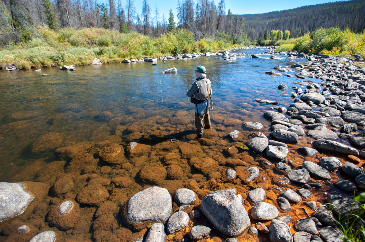
A fisherman on the upper Colorado River in northern Colorado. Low water flows have endangered fish populations and led last year to the closing of parts of the river and its tributaries to fishing and other recreation. PHOTO BY TED WOOD
Razorback suckers, once common, are now rare. The bonytail, a type of chub that is one of North America’s most endangered fish, no longer exists in the wild. A handful of these fish exist in hatcheries, and attempts are underway to restock them in the river throughout the basin.
Because of the Colorado’s extensive infrastructure, serious disruption of the river’s ecology is inevitable. Dams trap most of the river’s sediment in reservoirs, which means there is no material to rebuild beaches, sandbars, and important fish habitat downstream.
Dams also deprive the river downstream of nutrients, such as phosphorous and nitrogen, and stratify water temperatures. The native fish in the Colorado adapted to a wide range of temperatures, from cold to very warm. They also evolved to tolerate high flood flows along with extremely dry periods. Now, the water is cold in the summer for miles below the dams, and the humpback chub and other fish that had adapted to a range of water temperatures and flows suffer.
Something called hydro-peaking also has had serious impacts on the food web. Dams generate power according to demand. As people come home from work and switch on the stove, air conditioning, and lights, demand soars and dams release more water to produce power. “Prior to the construction of dams, there were almost no major daily changes in river levels,” said David Lytle, a professor of integrative biology at Oregon State University. When fluctuations in water levels occur, they “can interrupt the egg-laying practices of some species. It’s a serious problem.”
Paradoxically, two of the Colorado’s most important wetlands are the product of runoff from irrigation.
Insects lay their eggs just below the water level, and if levels drop rapidly it can dry them out. A recent study found that below the Hoover and Glen Canyon dams, there was a complete absence of stoneflies, mayflies, and other species — insects that are vital food for fish, bats, birds, and other creatures.
Because of the ecological effects of the Glen Canyon Dam, the Grand Canyon stretch of the Colorado is one of the least productive sections of river in the world. The Colorado here will always be highly unnatural, a novel, human-created ecosystem with some natural elements.
Today, there is a large and growing backlash against dams in America and elsewhere as the immense damages they have inflicted on rivers become manifest. Few dams, though, are as reviled as the Glen Canyon, which was built in 1963 and took 17 years to fill Lake Powell.
Before the Glen Canyon was dammed, those who saw it say it was not unlike the Grand Canyon, with towering walls of red, tan, and ochre. Early Native American sites were plentiful. Environmental activist Edward Abbey decried the dam, and in his novel the Monkey Wrench Gang fantasized about using houseboats packed with explosives to blow it up. In 1981, members of Earth First!, a radical environmental group with a connection to Abbey, rolled a black plastic “crack” down the face of the dam to symbolize its demise.
Lake Powell in Utah stores water from the Upper Colorado Basin for delivery to Lake Mead, the key reservoir on the Colorado. In the last water year, storage in Lake Powell has fallen by 1.54 million acre-feet, and the lake is only 39 percent full. PHOTO BY TED WOOD
Removing the dam was part of the reason the Glen Canyon Institute was formed, but activists have now dropped that idea, says Rich Ingebretsen, a Salt Lake City physician who founded the group. Today, he advocates draining Lake Powell to fill Lake Mead, which is downstream and where the need for water is by far the greatest. The “Fill Mead First” campaign would restore a free-running Colorado River to what was once Lake Powell.
“You’d get much of Glen Canyon back,” said Ingebretsen. “A free-flowing river through the Grand Canyon means you’d restore the river — riparian zones, animals that belong there, a beautiful canyon with arches and bridges and waterfalls. Much of that would come back very quickly.” There would also be increased water in the river, he says, because so much of the Colorado is now lost from Lake Powell; scientists estimate that the lake loses three times Nevada’s allotment of water because of evaporation. As levels in Lake Mead drop due to prolonged drought, a growing number of people are taking this idea more seriously.
Paradoxically, two of the Colorado River’s most important wetlands for wildlife are the product of runoff from irrigated farm fields — and are now at risk from a changing climate and agreements to reduce water use.
In the Sonoran Desert of northwestern Mexico, the 40,000-acre La Cienega de Santa Clara wetland was inadvertently created in the 1970s when U.S. officials built a canal to dispose of salty wastewater from agricultural fields in Arizona. As the water began spilling into the desert, myriad forms of life began to appear. Now its cattail-studded marshes and mudflats are considered one of the most important wetlands in North America, home to 280 species of birds — including the endangered Ridgeways rail — on what was once hard-baked desert.
The largest project to restore some semblance of nature on the Colorado is in the delta.
Meanwhile, in California, the Salton Sea was once a shallow inland lake whose levels routinely fluctuated. In 1905, an effort to increase Colorado River flow into the Imperial Valley led farmers to allow too much river water into their irrigation canal, overwhelming their system; for two years the water poured into the 35-mile-long, 15-mile-wide Salton Sea and expanded it.
But as less water becomes available to agriculture and rising temperatures cause more water to evaporate, scientists are concerned that these wetlands will dry and shrink faster than they already have. A 2003 agreement, for example, allows agricultural water in the Imperial Valley to be sent to San Diego for municipal uses. That could cause water levels in the Salton Sea to drop by more than 40 percent, dramatically reducing bird habitat and increasing toxic dust because wetlands would dry out. Local, state, and federal officials have devised a plan — still not fully funded — to restore 15,000 acres of wetlands, at a cost of more than $700 million.
Francisco Zamora, of the Sonoran Institute, and botanist Celia Alvarado walk in a cottonwood forest they helped restore at Laguna Grande in the Colorado River delta. More than 700 acres of land in the delta have been reforested. PHOTO BY TED WOOD
The largest project to restore some semblance of nature to the Colorado River, though, is in the delta. An unusual agreement in 2012 between the U.S. and Mexico, called Minute 319, mandated that the two countries would provide water and funding to revive sections of the delta and release a one-time pulse of 105,000 acre-feet to again connect the river to the delta temporarily. Scientists would then study the effects.
In 2014, for the first time in decades, the river flowed again in Mexico — for eight weeks. San Luis Rio Colorado — once a Colorado River town, but now a dusty desert settlement — became a river town for two months, to the delight of locals, many of whom had never seen the river. The pulse offered a glimpse of what reclamation efforts might look like. “It gave us an idea of how the river behaves, and the best sites for restoration,” said Zamora.
Minute 319 and its 2017 replacement, Minute 323, have funded the restoration of sections of the river. A group of nonprofits — including the National Audubon Society, the Sonoran Institute, The Nature Conservancy, and a Mexican group called Pronatura Noroeste — is working on a project called Raise the River to revive a significant swath of the delta.
In 2008, the group secured rights to 1,200 acres along the desiccated river channel. Since then, local residents have torn out acres of salt cedar and planted irrigated fields of cottonwood, willow, and other endemic species — more than 200,000 trees in all. A small supply of water mandated by the treaty, along with excess water that flows off of irrigated fields, have been dedicated to the restoration.
On a recent visit, I joined Zamora and botanist Celia Alvarado on a short boat ride to Laguna Grande, a 6-mile section of restored river and estuary. We skimmed across still water the color of weak tea, minnows darting away from our paddles. Thick groves of cottonwoods and willows lined the river. Zamora remarked that bobcats and beaver lived there now, along with blue grosbeaks and yellow-billed cuckoos. “Impacting the target species is key,” he said.
And what about the jaguar? I asked. It has not returned, he said. Will it come back?
“Yes,” said Zamora, smiling. “Someday. If they allow me to introduce them.”
Water levels in California’s Salton Sea are dropping, as less Colorado River is reaching it, causing a loss of wetlands that serve as critical bird habitat. Officials have devised a $700 million plan to restore 15,000 acres of wetlands, but the project is still not fully funded. PHOTO BY TED WOOD
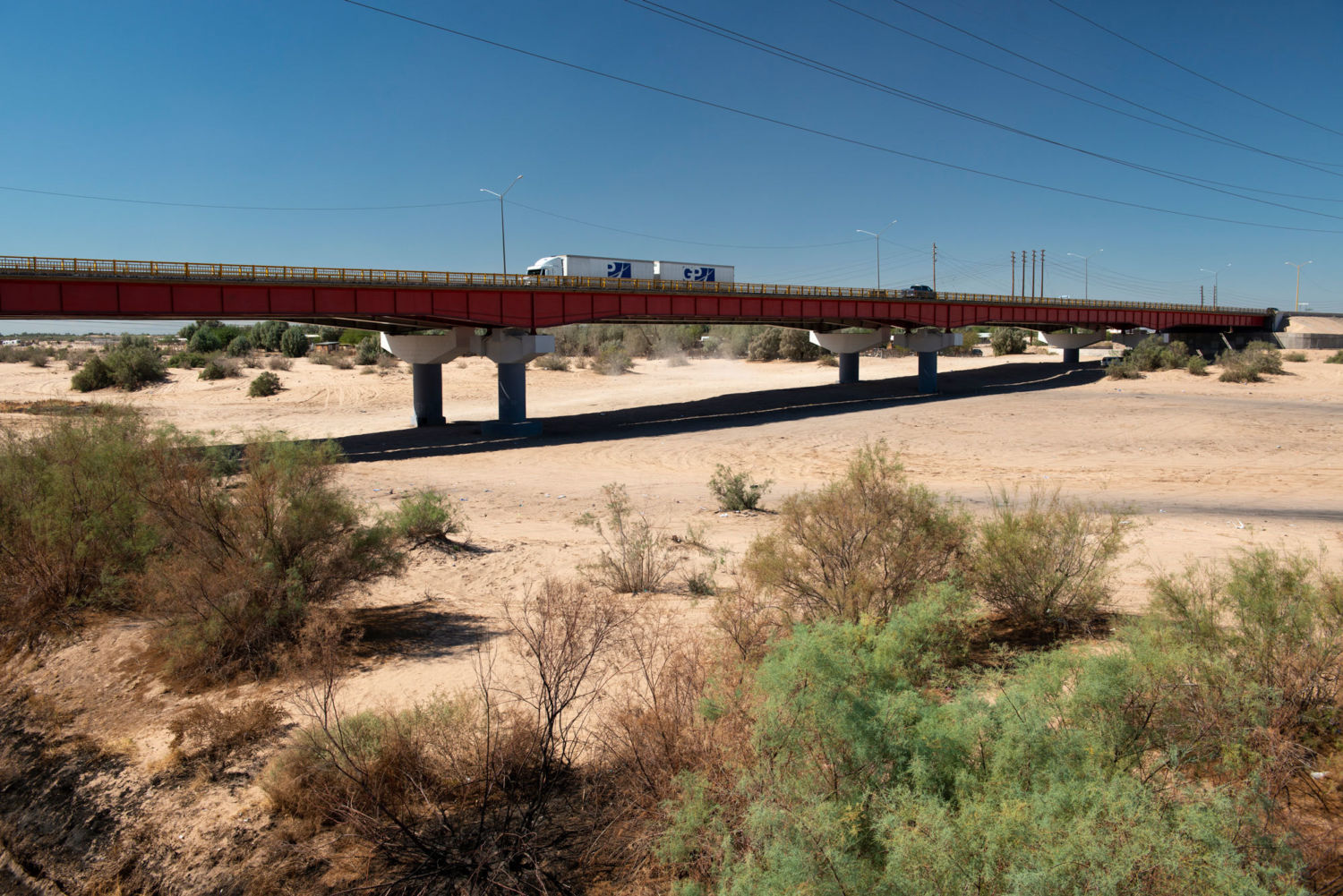
A highway passes over the dry, historic riverbed of the Colorado River near the town of San Luis Rio Colorado in Baja California, Mexico. PHOTO BY TED WOOD
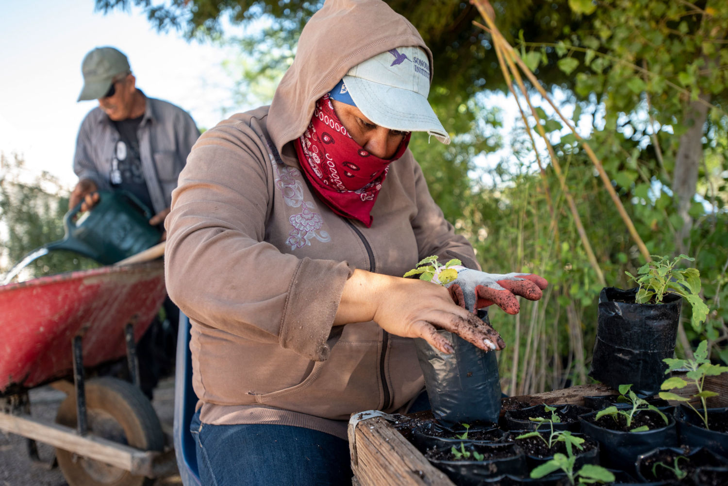
A volunteer repots a seedling at the Sonoran Institute’s nursery in Baja California. The seedlings, indigenous to the Colorado River delta, will be replanted at Laguna Grande to help restore the delta’s natural forests and marshes. PHOTO BY TED WOOD
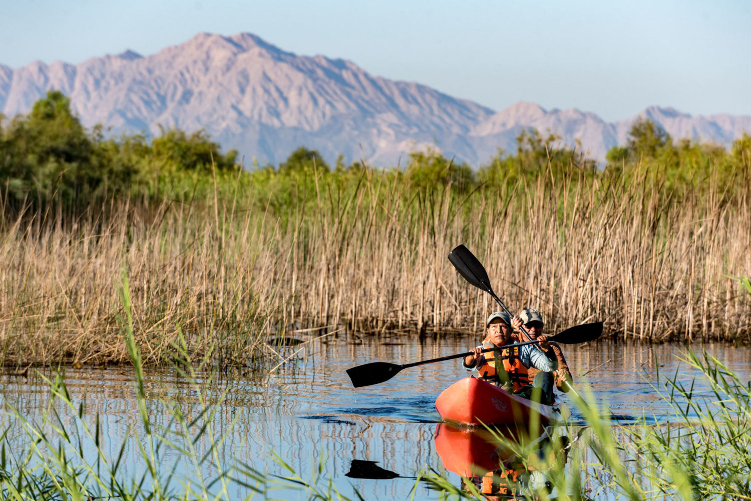
Botanist Celia Alvarado and Colorado River delta project leader Francisco Zamora kayak the waterways of Laguna Grande, a restored portion of the delta. The project uses agricultural return flow and purchased irrigation water to revive riparian habitat in the delta. PHOTO BY TED WOOD
From the air, much the Colorado River delta looks like a mosaic, a patchwork of old river channels and desiccated lands. PHOTO BY TED WOOD
The Colorado River once flowed into the Gulf of California (upper right), but today the river’s delta is largely dried out. Without the river water and its load of nutrients, marine productivity in the Gulf has fallen by up to 95 percent. PHOTO BY TED WOOD
Ted Wood (tedwoodphoto.com) is a photojournalist and multimedia producer based in Boulder, Colorado. He specializes in environmental and conservation stories, particularly in the western United States. His work has appeared in Vanity Fair, Smithsonian, Audubon, and dozens of other national and international publications. Wood is also the co-founder of The Story Group, a multimedia journalism company in Boulder.
Once criticized for being a profligate user of water, fast-growing Phoenix has taken some major steps — including banking water in underground reservoirs, slashing per-capita use, and recycling wastewater — in anticipation of the day when the flow from the Colorado River ends.
The Hohokam were an ancient people who lived in the arid Southwest, their empire now mostly buried beneath the sprawl of some 4.5 million people who inhabit modern-day Phoenix, Arizona and its suburbs. Hohokam civilization was characterized by farm fields irrigated by the Salt and Gila rivers with a sophisticated system of carefully calibrated canals, the only prehistoric culture in North America with so advanced a farming system.
Then in 1276, tree ring data shows, a withering drought descended on the Southwest, lasting more than two decades. It is believed to be a primary cause of the collapse of Hohokam society. The people who had mastered farming dispersed across the landscape.
The fate of the Hohokam holds lessons these days for Arizona, as the most severe drought since their time has gripped the region. But while the Hohokam succumbed to the mega-drought, the city of Phoenix and its neighbors are desperately scrambling to avoid a similar fate — no easy task in a desert that gets less than 8 inches of rain a year.
“We are fully prepared to go into Tier 1, 2, and 3 emergency,” said Kathryn Sorensen, Phoenix’s water services director, referring to federally mandated cutbacks of Colorado River water as the levels of Lake Mead, the source of some of the city’s water, continue to drop. And what of the dreaded “dead pool,” the point at which the level in the giant man-made lake falls so low that water can no longer be pumped out?
As Colorado River supplies dwindle, Kathryn Sorensen, director of Phoenix Water Services, is racing to find new ways to conserve and store water for the sprawling city of 1.6 million people. PHOTO BY TED WOOD
“I can survive dead pool for generations,” says Sorensen, pointing to a host of conservation and water storage measures that have significantly brightened the city’s water outlook in an era of climate change and drought.
These days, Phoenix’s alternative water supplies are not dependent on the Colorado. But there’s a caveat. Phoenix may have enough water to secure its near-term future, but it still needs to build $500 million of infrastructure to pipe it to northern parts of the city that now rely on Colorado River water. And Phoenix may need the water sooner than it planned. “You could hit dead pool in four years,” Sorensen said. “That’s worst case.”
Many cities and towns in the Southwest — including Los Angeles, San Diego, and Albuquerque — are trying to figure out solutions to a dwindling Lake Mead, the key reservoir on the Colorado. One of the most ambitious efforts is a new $1.35 billion, 24-foot-wide tunnel — the so-called Third Straw — that Las Vegas drilled at the very bottom of Lake Mead to function like a bathtub drain. Las Vegas gets 90 percent of its water from the Colorado via the lake, which is located just east of the gambling and tourist mecca. In 2000, as the lake’s level dropped, the city placed a second, deeper straw to replace the original outtake. As the region moved into its second consecutive decade of drought and lake levels continued to drop, Las Vegas officials got more nervous and the third straw was completed in 2015; it should continue to siphon off water unless the lake dries up completely.
Supplying enough water to sustain a city this size in the desert has long been controversial.
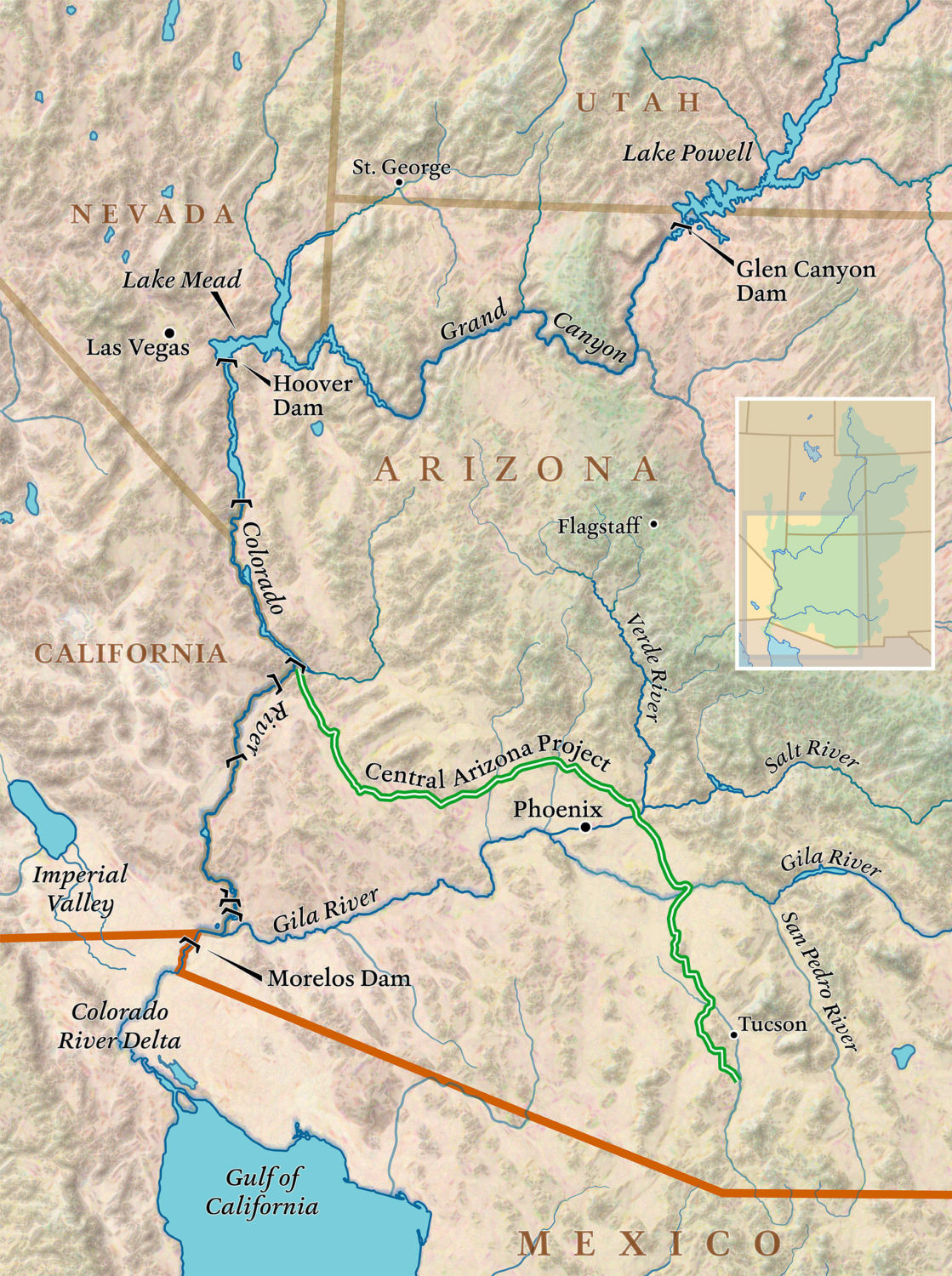
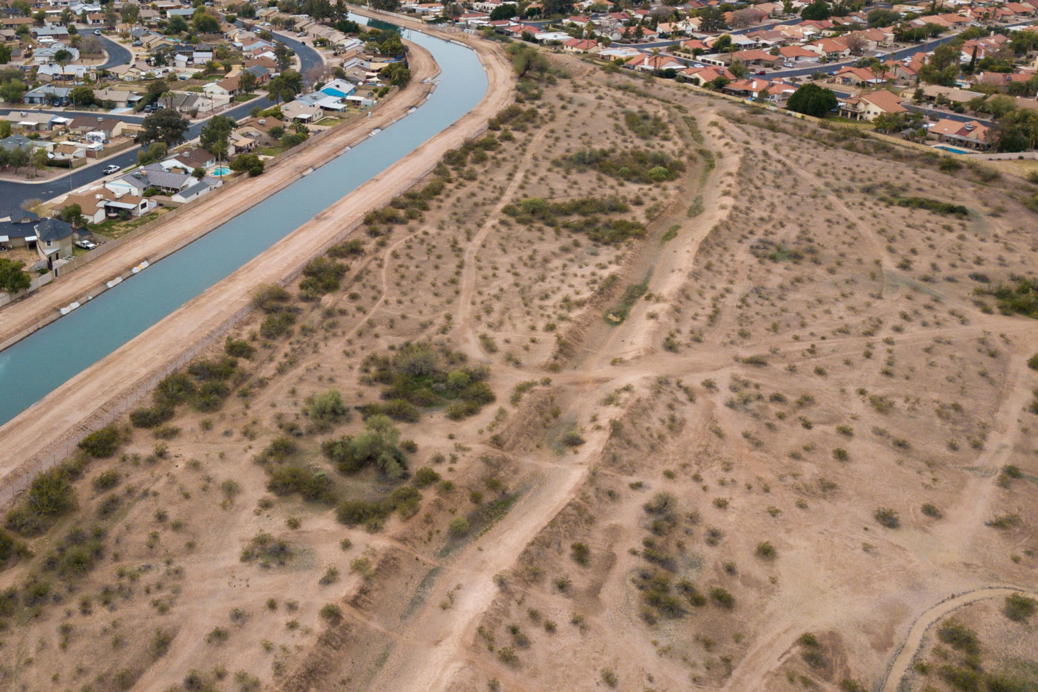
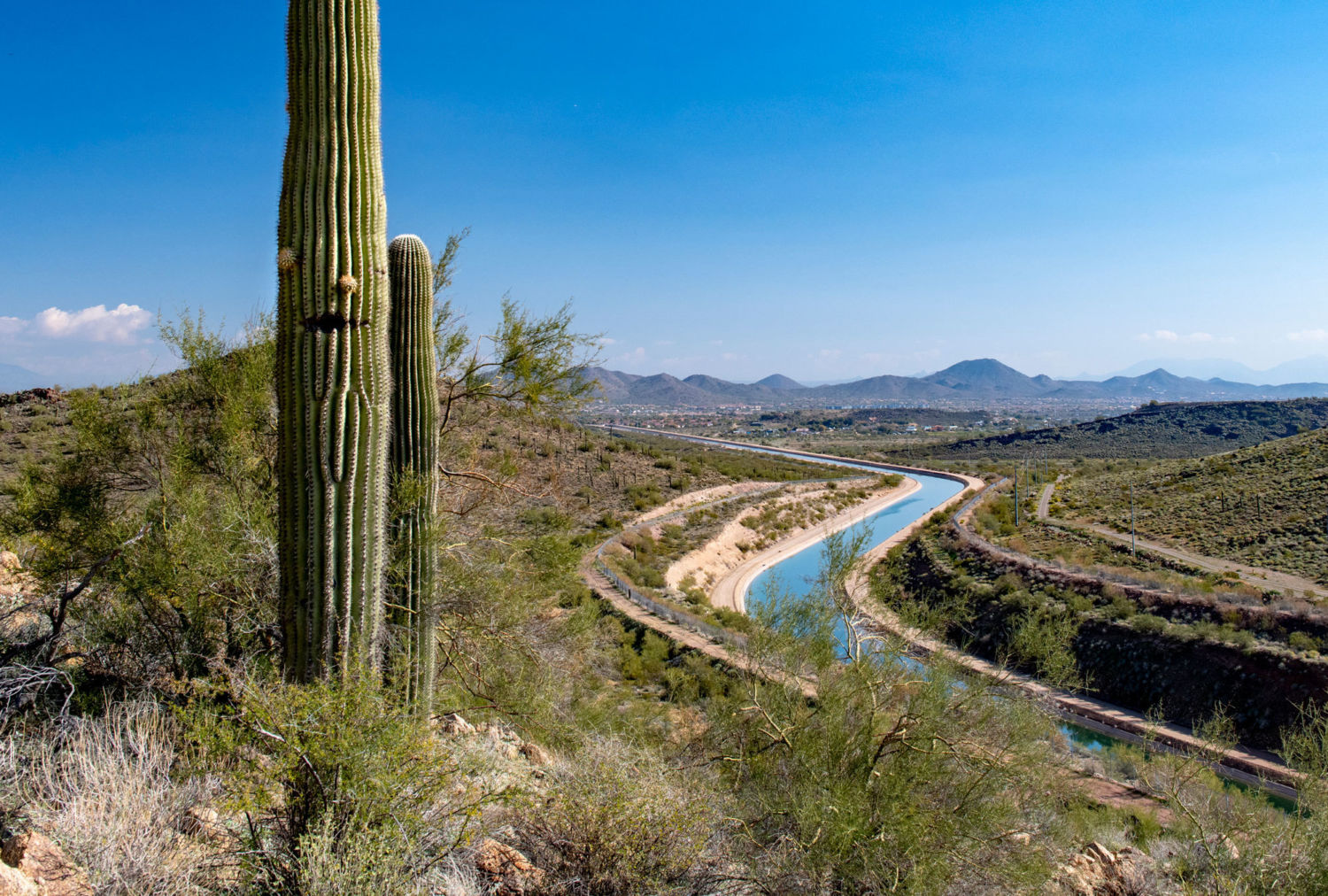
In Arizona, the modern equivalent of the Hohokam irrigation system is the 17-foot-deep and 80-foot-wide concrete aqueduct called the Central Arizona Project, which carries water from the Colorado River to Phoenix, Tucson, and elsewhere. It was a feat of engineering when it was finished in 1993, snaking across the sere desert landscape for 336 miles as it pumps water up 2,900 feet in elevation. So much power is needed to flush this water along its route that the massive coal-fired Navajo Generating Plant was built to provide it.
Supplying enough water to sustain a city this size in the desert has long been controversial, and as Phoenix and its neighbors continue their unrelenting sprawl — Arizona’s population has more than tripled in the past 50 years, from 1.8 million in 1970 to 7.2 million today — the state has often been regarded as the poster child for unsustainable development. Now that Colorado River water appears to be drying up, critics are voicing their “I told you so’s.”
That’s a bad rap though, at least for Phoenix, according to Sorensen. The city is prepared to carry on with business as usual even if the last of the Colorado River water evaporates into the desert sky, depriving Phoenix of 40 percent of its water supply. City officials have been busy planning for this eventuality, and much of the responsibility for that has fallen to Sorensen.
The Central Arizona Project stretches 336 miles, delivering water from the Colorado River to communities in central and southern Arizona. MAP BY DAVID LINDROTH FOR YALE ENVIRONMENT 360
As she stands behind her large desk on the 9th floor of the municipal building in the heart of downtown Phoenix, surrounded by windows that look out on glass office towers gleaming in the desert sun, Sorensen deftly handles questions about the city’s water future. On her desk sits a crystal ball, a joke gift that she says she wishes was real. She’s proud of the work she has done since she was appointed in 2013 — before that she served four years as head of Mesa, Arizona’s water department — although she admits it has been a challenge.
The Phoenix Water Services Department is one of the nation’s largest, with 1.5 million customers spread out across 540 square miles. It maintains 7,000 miles of water lines and 5,000 miles of sewer lines.
The Salt River is the single biggest source of water for metro Phoenix, and provides about 60 percent of its needs. It is a large desert river, some 200 miles long, that begins at the confluence of the snow-fed White and Black rivers, is joined by a series of perennial, spring-fed streams, and then meets the Verde River east of Phoenix.
Just after the turn of the 20th century, the first of four dams was constructed on the Salt for a growing Phoenix, and today those reservoirs are Phoenix’s main water supply. However, Phoenix’s north side gets only Colorado River water, and should that source dry up one day, constructing infrastructure to connect north Phoenix to new sources of water would cost a half-billion dollars. Funding for such a project would hardly be a fait accompli; in late December, the Phoenix City Council rejected a water rate increase to pay for the infrastructure expansion. The Salt and Gila rivers also may someday be severely impacted by climate change. “They could be affected by a mega-drought,” said Andrew Ross, a sociology professor at New York University and author of Bird on Fire: Lessons from the World’s Least Sustainable City. “They are in the bullseye of global warming, too.” Perennial streams could dry up and snowfall in Arizona’s White Mountains could dwindle, as it has done in the Rockies, further depriving the rivers of a steady supply of water.
“We’ve decoupled growth from water,” says a city official. “We use the same amount of water we did 20 years ago.”
Beyond the Salt River, Phoenix has undertaken some innovative water strategies. Among the first of these was the Arizona Water Bank. California is entitled to 4.4 million acre-feet of water a year from the Colorado, but because Arizona was not using its full allotment of 2.8 million acre-feet, its excess water was being slurped up by a perpetually thirsty California. So the water bank, a unique system of underground storage, was created in 1996 as a way to store Colorado River water that the state couldn’t use, rather than letting it flow through to California. It turned out to be a prescient move, but not for the reason it was created. In that era, few people foresaw the crash of the Colorado River system.
Arizona has since created seven water banks, largely in empty underground aquifers. A series of large pools has been built above the aquifers and, as water is pumped into them, it slowly leaches through a layer of gravel and rock and fills the aquifer. So far the water banks have cost the state $330 million, storing 3.6 million acre-feet in 28 sites across three counties — more than a year’s worth of Colorado River water.
One of the largest water banks is 40 miles west of Phoenix near the tiny town of Tonopah, Arizona. The nearly $20 million facility has 19 infiltration basins covering more than 200 acres. It was constructed alongside the Central Arizona Project canal, and a pipe delivers 300 cubic-feet-per-second of Colorado River water a day to fill the basins.
The Granite Reef Underground Storage Project, a water bank located on Salt River Pima-Maricopa Indian Community land, is a partnership between Phoenix and other regional municipalities. It funnels water from the Salt and Verde rivers and the Central Arizona Project into ponds, where it leaches into underground aquifers for later use. PHOTO BY TED WOOD
In addition, other aquifers underneath Phoenix are brimming with 90 million acre-feet of water, some natural and some pumped in — enough to last the city for years. One problem is that much of it is contaminated, both from natural sources of arsenic and chromium and from the city’s many Superfund sites, which include manufacturing sites polluted by industrial solvents and unlined landfills that contain hazardous waste. But Sorensen dismisses the cleanup challenges as surmountable. “As long as the contamination isn’t nuclear, we can fix it,” she says. “What matters here is that the water is wet.”
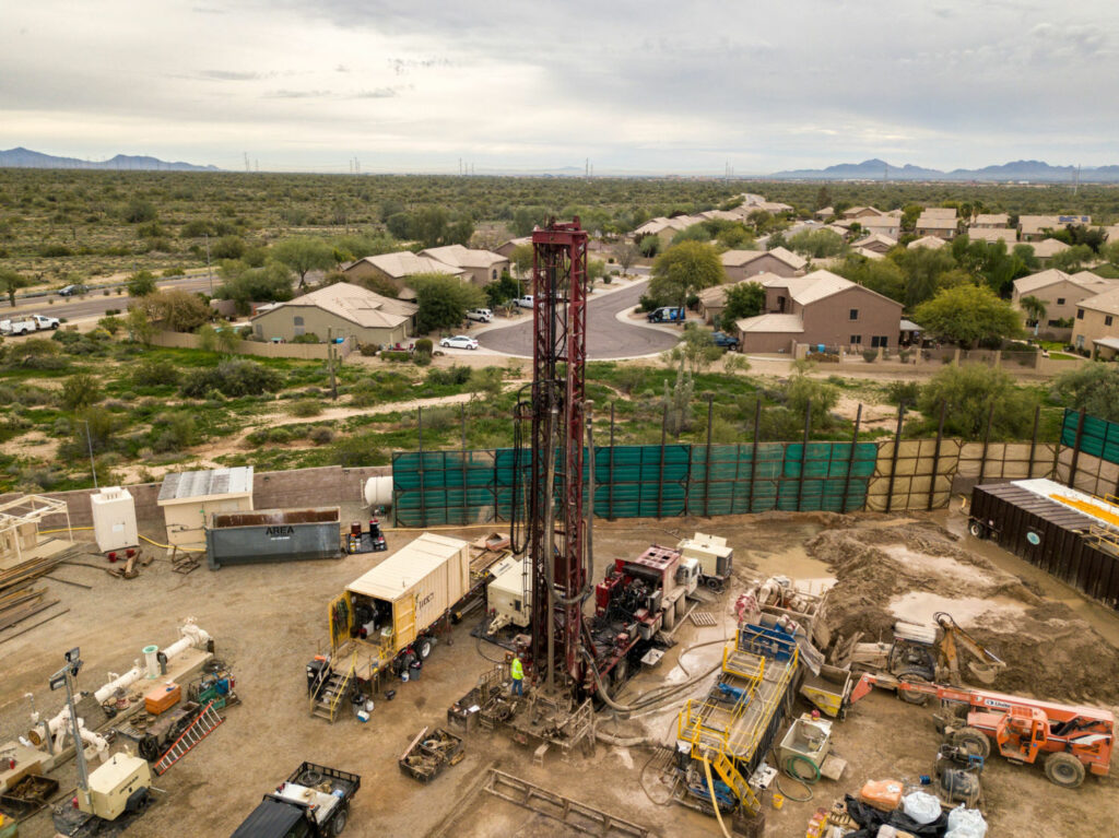
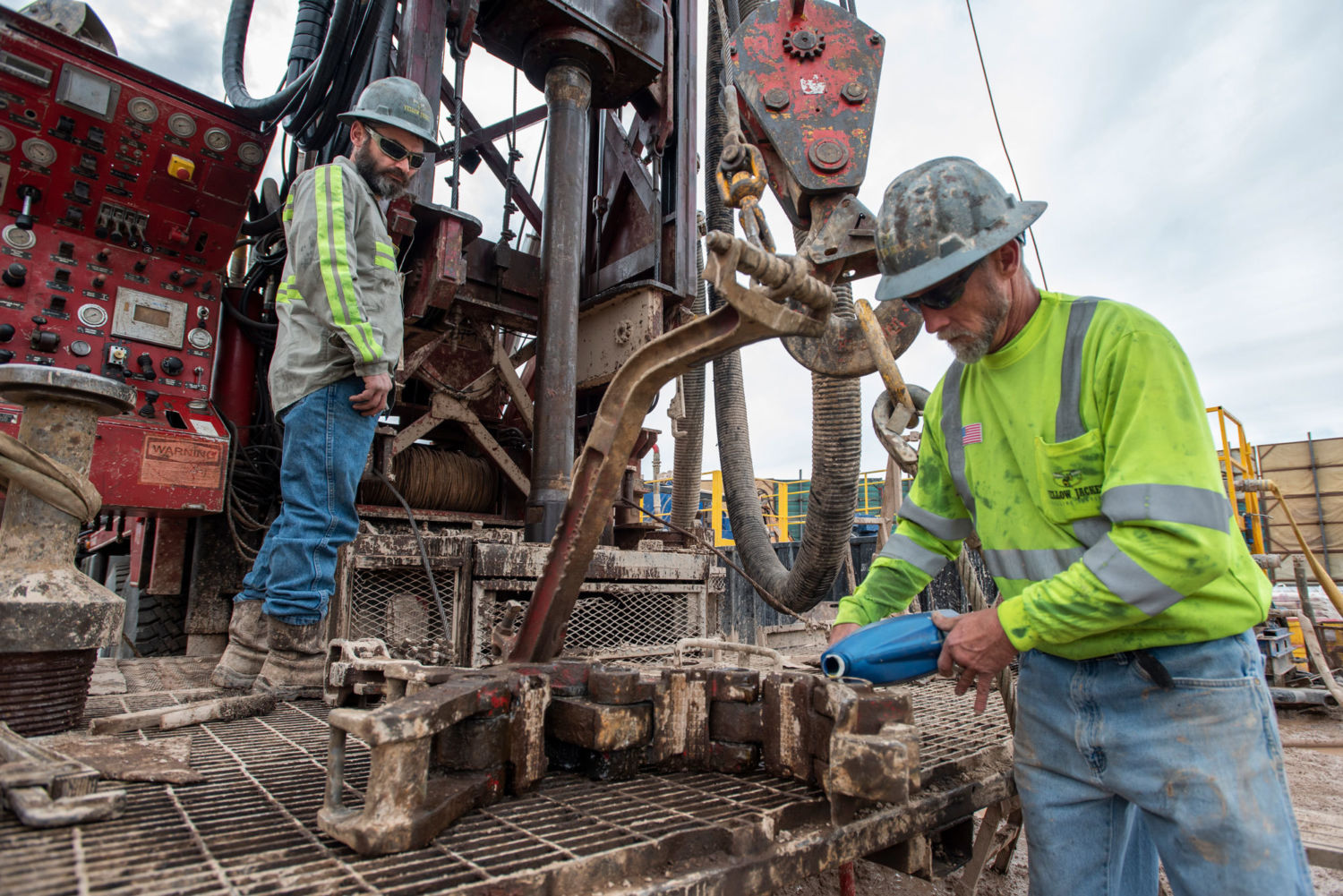
An aquifer storage and recovery well being drilled in the Desert Ridge neighborhood of North Phoenix. When complete, the well, which will support 10,000 homes, will be used to either store water 1,540 feet underground or pull it back up when surface supplies run low. PHOTO BY TED WOOD
Phoenix also recycles almost every bit of wastewater that journeys through its system. The vast majority of it — more than 20 billion gallons of recycled water a year — goes to cool the Palo Verde Nuclear Power Plant. Another 30,000 acre-feet is traded to an irrigation district as gray water to use on agricultural fields and the district, in turn, sends potable water from the Salt River to the city.
And the city is working on “toilet-to-tap” technology aimed at someday making sewage water so clean it will be drinkable. The technology for recycling wastewater into drinking water exists, but is only used in a few places, including San Diego. Arizona says it will play a role in its water supply some day — if, that is, the city can sell the idea to consumers.
Desalinization of seawater has long been floated as a possibility for Arizona, and much of the U.S. Southwest, and officials say it too will be part of Arizona’s water mix — someday. The process, which forces water through an extremely fine filter, is energy-intensive, extremely expensive, and a major environmental problem because of the waste it generates. Nonetheless, Arizona sits on top of 600 million acre-feet of brackish water, and officials have also considered treating water from the Gulf of California, nearly 200 miles to the southwest.
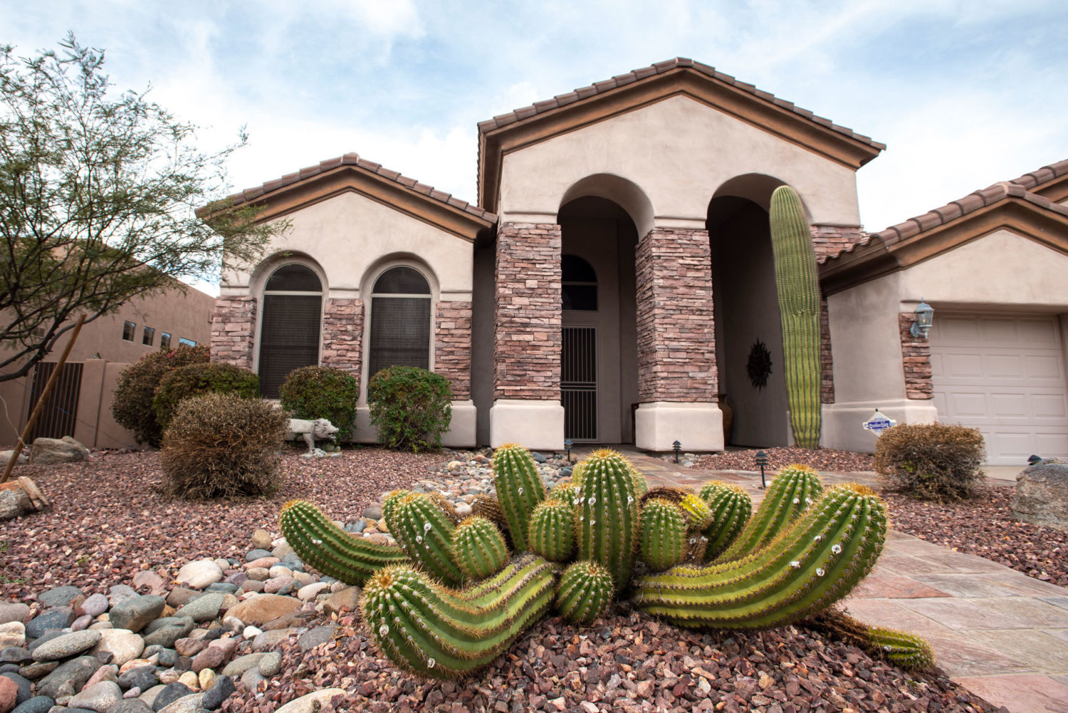
Phoenix homeowners have scrapped lawns for desert landscaping and artificial turf to reduce water use. City residents use 30 percent less water per capita than they did 20 years ago. PHOTO BY TED WOOD
For now, though, Phoenix appears to have positioned itself well for a new era of drought. Sorensen credits the people of Phoenix for adapting to the desert by using far less water per capita. “We’ve decoupled growth from water,” she said. “We use the same amount of water that we did 20 years ago, but have added 400,000 more people.” In 2000, Some 80 percent of Phoenix had lush green lawns; now only 14 percent does. The city has done this by charging more for water in the summer. Per capita usage has declined 30 percent over the last 20 years. “That’s a huge culture change,” Sorensen says.
In fact, the decoupling of water from growth through conservation has taken place throughout the Lower Colorado Basin. “Actual municipal water use across the basin, with the exception of Utah, is declining, even as population rises,” said John Fleck, director of the University of New Mexico Water Resources Program. “Albuquerque has built its long-range plan around conserving more than its demand for decades to come, and Las Vegas’ demonstration of its ability to use less water is stunning.”
But while Phoenix and Las Vegas are pursuing conservation strategies as a partial solution to the withering of the Colorado River, others entities in the region aren’t. Much of conservative Arizona is in denial about what the potential drying of the West may mean, if they recognize it at all. “We’re just starting to acknowledge the volatile water reality,” said Kevin Moran, senior director of western water for the Environmental Defense Fund. “We’re just starting to ask the adaptation questions.” Ross, of New York University, argues that the biggest problem for Arizona is not climate change, but the denial of it, which keeps real solutions — such as reining in unsustainable growth or the widespread deployment of solar energy in this sun-drenched region — from being considered. “How you meet those challenges and how you anticipate and overcome them is not a techno-fix problem,” he said, “It’s a question of social and political will.”
All these well-intentioned measures may fall far short of being able to cope with a full-blown climate crisis.
So, for now, Arizona’s rampant growth continues. To the west of Phoenix a new tech city is emerging. Mt. Lemmon Holdings, a subsidiary of computer magnate Bill Gates’s investment firm, Cascade Holdings, has plans to built a “smart city,” for example, on the outskirts of Phoenix near the town of Buckeye. The new city, on 24,000 acres — about the same size as Paris — would have infrastructure for self-driving cars, hi-tech factories, and high-speed public wi-fi.
Meanwhile, the so-called Sun Corridor — 120 miles of Sonoran Desert between Phoenix and Tucson — is seen as the state’s next burgeoning megalopolis. It’s one of the fastest-growing regions in the country and its population of more than 5.5 million — anchored by Phoenix in the northwest and Tucson to the southeast — is expected to double by 2040.
And what about the water for this growth? Under state law, a developer must prove it has a 100-year supply for any new housing development. The primary solution for that has been for the Central Arizona Groundwater Replenishment District to fill or replenish aquifers where growth is planned — and the source for that is the precarious Colorado River water.
The remnants of canals used by the Hohokam people for centuries can still be seen in the sandy soil here in Mesa, Arizona, with the ancient canal path running parallel to the modern-day South Canal, which carries water from the Salt River. PHOTO BY TED WOOD
Phoenix officials have urged businesses and government agencies to plant desert landscaping to lower water use. PHOTO BY TED WOOD
Cutting through the desert for most of its route, the Central Arizona Project canal loses approximately 16,000 acre-feet of water a year to evaporation, or about 1 percent of its annual flow. PHOTO BY TED WOOD
A construction team works on an aquifer storage and recovery well being drilled in the Desert Ridge neighborhood of North Phoenix. Slated to become operational in two years, the well will provide access to groundwater and help meet water demands during drought and peak usage times. PHOTO BY TED WOOD
Construction of the $4 billion Central Arizona Project began in 1973 and took two decades to complete. The canal stretches from Lake Havasu on the Colorado River to its terminus southwest of Tucson, serving about 80 percent of Arizona’s population. PHOTO BY TED WOOD
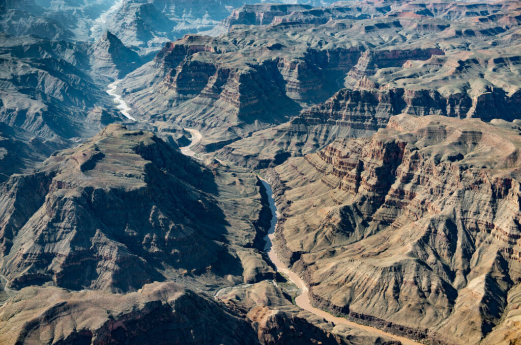
The Colorado River as it passes through the Hualapai Indian Reservation in Northern Arizona, west of Grand Canyon National Park. PHOTO BY TED WOOD
Ted Wood (tedwoodphoto.com) is a photojournalist and multimedia producer based in Boulder, Colorado. He specializes in environmental and conservation stories, particularly in the western United States. His work has appeared in Vanity Fair, Smithsonian, Audubon, and dozens of other national and international publications. Wood is also the co-founder of The Story Group, a multimedia journalism company in Boulder.
Communities along the Colorado River are facing a new era of drought and water shortages that is threatening their future. With an official water emergency declaration now possible, farmers, ranchers, and towns are searching for ways to use less water and survive.
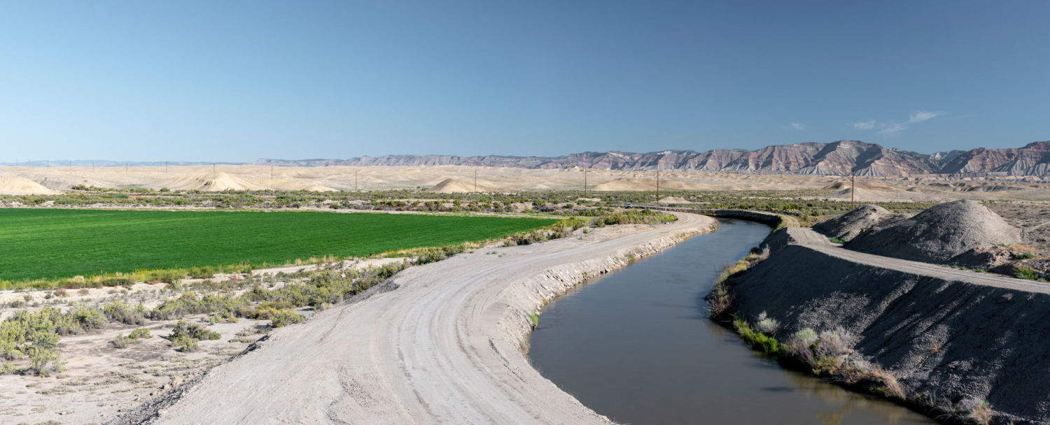
From the air, the Grand Valley Water Users Association canal — 10 feet wide and 8 feet deep — tracks a serpentine 55-mile-long path across the mountain-ringed landscape of Mesa County, Colorado. It’s a line that separates parched, hard-baked desert and an agricultural nirvana of vast peach and apple orchards and swaying fields of alfalfa.
The future of this thin brown line that keeps the badlands of the Colorado desert at bay, however, is growing more uncertain by the day.
Since 2000, the snow that blankets the Colorado Rockies each winter — the source of most of the river’s water — has tapered off considerably. Last year it was less than half of normal. So far, the farmers here have gotten their share of water, but this year could bring the first emergency declaration by water administrators. That would mean that some “junior” water users — those whose allocations came later — may have to forego their share in favor of senior users.
The nearly two decades of low snowpack is being called a drought, and tree rings show it’s the most severe in over 1,200 years. The term drought, however, implies it will end someday. But there are serious questions about whether this is a drought or a permanent drying of the West due to a changing climate.
If the water crisis deepens, farmers could see their neighbors start to disappear as farms and ranches are abandoned.
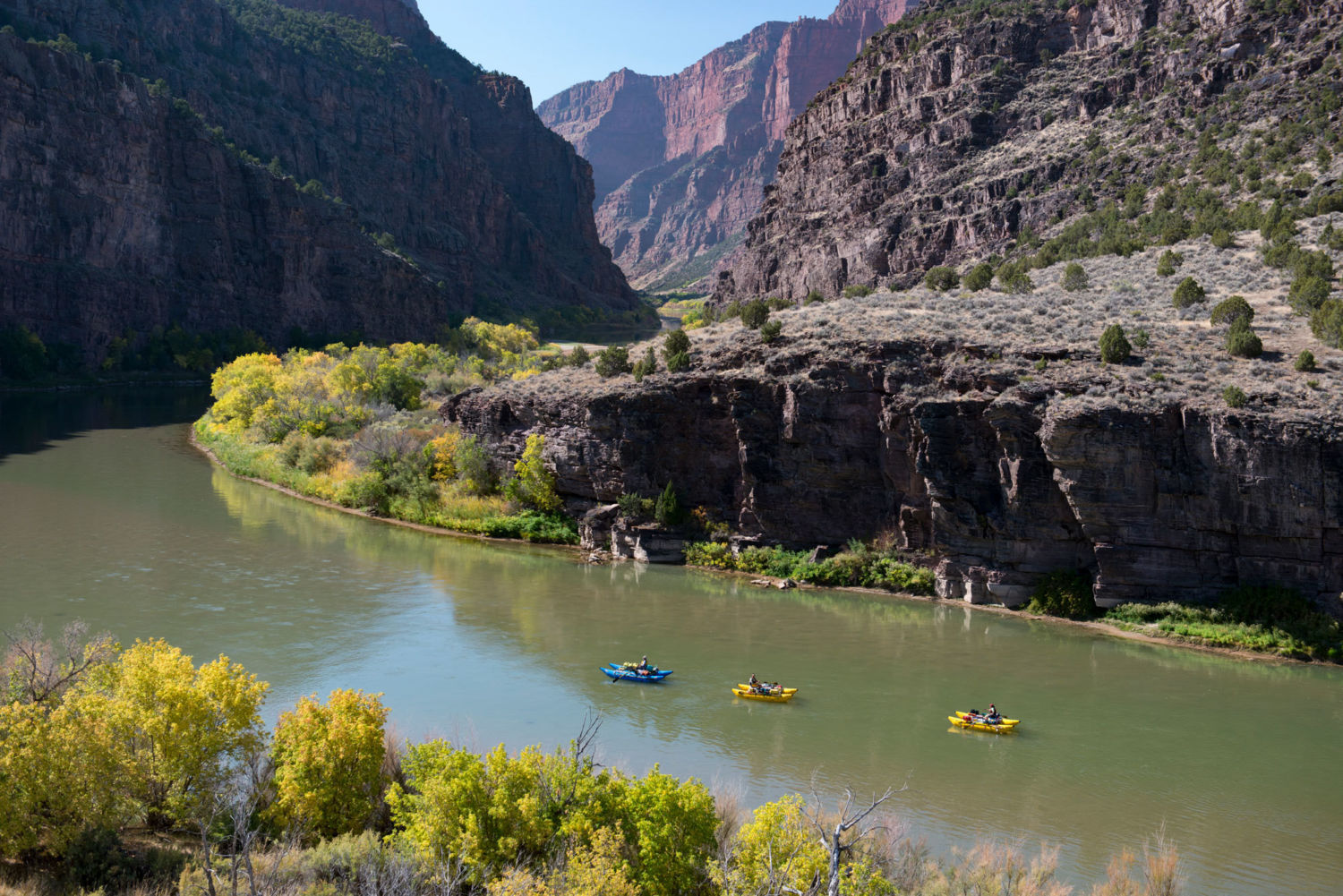
Few doubt that things are building toward crisis. Last year junior water users on the Yampa River, a tributary to the Colorado, were forced to face the new reality when officials ordered them to stop taking their allocated water and allow it to flow to senior users downstream. In places, the river channel was dry; fishing and float trips were also halted.
As things get tighter throughout the Colorado River Basin, irrigators, who control 80 percent of the water on the river, fully expect others to come looking for their water. One place that has been preparing a strategy to try and head off a raid on its water is in Mesa County in western Colorado.
“There is not an active attack on our water at this time,” said Mark Harris, general manger of the Grand Valley Water Users Association and a farmer himself, as we walked along a row of peaches in a sea of orchards near Palisade, Colorado. “But we do have a huge target on our back. The crisis will require draconian measures that will savage ag. If municipalities run out of sanitary water or fire water, those steps are going to have to be taken.”
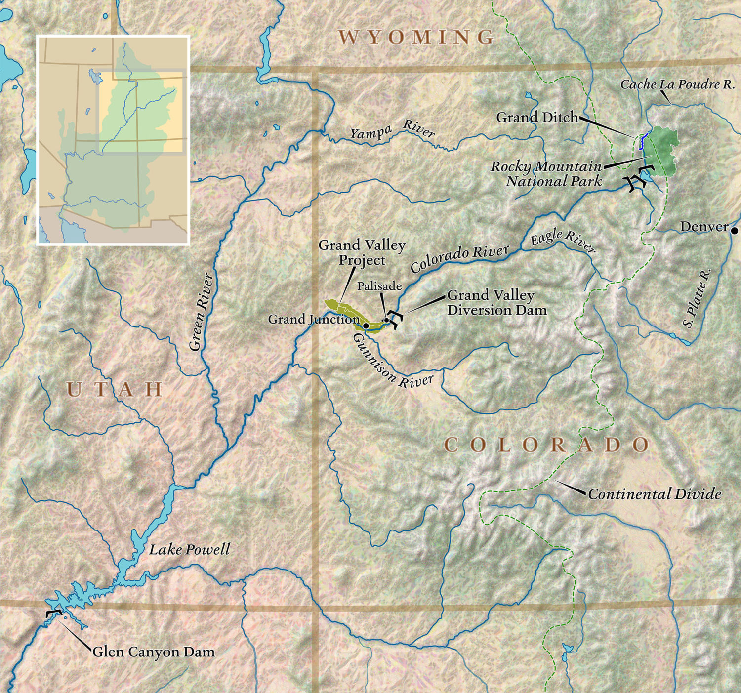
The Grand Valley, a major agricultural zone in western Colorado, depends on water from the Colorado River. MAP BY DAVID LINDROTH FOR YALE ENVIRONMENT 360
The Grand Valley Water Users Association was founded in 1905 as part of the U.S. Bureau of Reclamation. It operates the canal, as well as 150 miles of pipe and open ditch that carry water to a little more than 23,000 acres of land. Without water to service this network — and with only 9 annual inches of precipitation — a new dust bowl could be in the offing.
Water law in the West is based on something called the Prior Appropriation Doctrine, or “first in time, first in line.” While water is a public asset, rights to it were promised to those who came West to homestead, ranch, and grow crops in the late 19th and early 20th centuries. They have the most senior rights, and these are considered private property rights, enshrined in law. The rights of cities and towns are usually junior to these senior rights, and junior users stand to lose out first if cutbacks are mandated. However, cities and towns have considerable political and economic heft, especially in metropolitan areas in the Lower Basin, such as Phoenix, Las Vegas, and Los Angeles. The fear is that the policy of “first in time, first in line” could be discarded in a time of emergency and replaced with one that adheres to a different adage — “water flows uphill toward money.”
The water that many farmers and ranchers use on the Colorado is now cheap. Senior users like those in the Grand Valley pay from $25 to $50 for an irrigated acre for the season. A hundred acres of, say, alfalfa, the single largest crop along the river, needs up to 2 feet of water per acre. Water to irrigate for the season then, would cost the farmer about $2,500 to $5,000. The net profit from the hay is about $300 an acre, so the farmer would make about $30,000 on the 100 acres after costs.
Mark Harris, general manager of the Grand Valley Water Users Association.
Currently water is selling on the open market for about $200 to $250 an acre-foot for a season, well above what farmers in the Grand Valley are paying. The rules of the Grand Valley Water Users Association do not permit separating water from the land; but if the exigencies of the drought were to cause the rules to change, on today’s market the value of the water from those 100 acres would be worth about $40,000 for a season. In that case, farmers could make more money selling their water rights than by continuing to farm. And if the crisis were to deepen and junior users such as the city of Denver were to lose their water and needed to look elsewhere, the lease price of an acre-foot for the season could go as high as $1,000, some experts say. That would mean farmers could make $100,000 annually by selling their water rights and fallowing their 100 acres.
“We don’t want an unfettered free market for water,” said Harris. “That would be a disaster,” with a range of unintended consequences.While many farmers could do well financially in the advent of a crisis, those who continued farming would see their neighbors start to disappear as farms and ranches were abandoned. And if the crisis was prolonged or permanent, and more and more water was siphoned off to cities, it could threaten the very existence of farming communities around the basin.
It’s happened on a large scale before — most famously in California in the Owens River north of Los Angeles in the early 1900s, as depicted in the fictional 1974 film “Chinatown.” William Mulholland, head of the Los Angeles Department of Power and Water, secretly began buying up ranch and farmland with water rights along the Owens River in the eastern Sierras. Officials then built an aqueduct and piped that water to Los Angeles to fuel the city’s growth. The Owens Valley is now mostly arid.
Beyond the impact on the rural social fabric, dewatering agricultural areas in the Colorado Basin would cause other serious problems, from reducing food security, to less open space if the land were developed for housing, which would release the carbon sequestered in farm fields and eliminate wildlife habitat.
In the Grand Valley, some farmers are being paid to leave their land fallow and keep the water they would have used in the river.
That’s why places like the Grand Valley are taking unprecedented measures. “It’s time for preparation,” said Harris. “Preparation not panic, it’s a delicate balance.”
The Grand Valley Water Users Association has partnered with The Nature Conservancy, which is taking a lead role in helping agricultural interests find ways to survive the future, here in Mesa County and elsewhere in the Colorado River Basin.
In the last several years, an array of projects has been initiated around the basin — from western Colorado, to central and southern Arizona, to the upper Green River of Wyoming, to the borderlands of Mexico — to try to find solutions and, if they work, scale them up all along the Colorado. The Nature Conservancy, for example, has helped create a water bank here in the Grand Valley. Under a two-year pilot program, some farmers are paid to fallow their land — not grow anything on it — and leave the water they would have used in the river.
So far, Grand Valley farmers have fallowed 2,200 acres, which has enabled them to leave 6,000 acre-feet of water flowing in the Colorado. They were compensated for the loss of their crops, plus paid a premium for participating. Saving that water also helped the local irrigation district meet its obligations under the Endangered Species Act to protect fish by keeping more water in the river.
A system of canals, pipes, and ditches irrigate 23,000 acres of farmland in the Grand Valley with water from the Colorado River.
“We created a contract between all these states and Mexico that the hydrology doesn’t support,” said Taylor Hawes, head of the Colorado River program for The Nature Conservancy, referring to the 1922 Colorado River Compact which governs the allocation of water. “Ag and the environment will be the big losers if things continue, so we’re creating a more flexible system that adapts to the reality of our hydrology. Our goal is that whatever solutions we come up with for people also work for nature.”
The states of the compact are also working to find solutions. The Upper Basin states — Utah, New Mexico, Colorado, and Wyoming — have instituted a multi-faceted conservation program that tests ways to reduce water use, including fallowing land with compensation, irrigating crops with less water, and cutting back on municipal water use. The Lower Basin states — Nevada, Arizona, and California — are funding a host of initiatives; the city of Needles, California, for example, was given $500,000 to tear up sod at the city golf course and install drought-tolerant landscaping
The Lower Basin states are also working on a Drought Contingency Plan. As drought conditions continue to worsen, they are coming up with ways to voluntarily give up hundreds of thousands of acre-feet of water to keep Lake Mead, the key reservoir on the Colorado, above crisis levels. This would avoid the imposition of an officially declared emergency, which would force these states to make even larger cuts.
Farmers in Arizona’s Verde Valley are swapping out fields of alfalfa and replacing it with barley, which uses about half the water.
In Arizona’s Verde Valley, between Phoenix and Flagstaff, a different approach is being used. The Verde River is small, but a rare perennial desert river, borne of mountain springs in Arizona’s central highlands — a true oasis. It’s a tributary to the Salt River, which flows into the Gila River and on to the Colorado. It’s hard to overestimate the importance of desert rivers like this to biodiversity — 90 percent of all wildlife in deserts is found within a mile of a river. It’s also a critical water source for metro Phoenix.
A decade ago, The Nature Conservancy’s Kim Schonek came to the Verde Valley to work with local farmers to improve the river’s flow. The meandering, cottonwood tree-lined river is home to several endangered species, including the southwestern willow flycatcher and the loach minnow and spike dace, desert fish that are adapted to natural flows.
The project’s goal is to keep the flows no lower than at least 30 cubic feet per second or so, about a third of its natural level, but high enough to protect species. “We’re trying to re-establish the natural flow regime to the Verde,” says Schonek. “At that level, you have water in all your riffles and no stagnant pools, and that’s good for fish.”
The Nature Conservancy raised money from Coca-Cola, PepsiCo Recycling, Boeing, and other companies in Phoenix, as well as the city itself, all of which get water from the Verde and who have a stake in a more secure supply. With this funding, they are doing things such as updating irrigation technology to keep more water in the river.
Some of the fixes were simple. There were old-fashioned hand-cranked headgates along the river that farmers used to open or close by turning a wheel on top. Notoriously inefficient, the whole flow of the river was often diverted, and sections were inadvertently dried up for miles. The cantankerous headgates have been replaced with $40,000 electronic ones that neither the farmers nor the ditch companies could afford on their own.
Claudia Hauser is working with The Nature Conservancy to cut water use on her farm in Arizona’s Verde Valley.
“I used to have to go out at 2 in the morning and close that gate,” said Claudia Hauser, whose family has the largest agricultural holdings in the valley and has partnered with The Nature Conservancy to conserve water. “Now I can do it from the house with my phone.”
Other strategies have been more challenging. The Hausers are part of an experiment to swap out 144 acres of alfalfa and replace it with barley. Not only does barley use about half the water of alfalfa, it uses that water in the spring when the flows are high and doesn’t take water out of the river during critical summer periods. The Nature Conservancy has also raised money to build a small barley malting facility, Sinagua Malt, to get the malt ready for beer brewers. Local breweries have snapped up this malt and use it for their beer, and the fact that it is helping save the Verde has become a marketing point. “It’s the essence of naturalism and conservation that truly excites this brewery!” the Arizona Wilderness Brewing Company boasts on its homepage.
Farmers in the Verde Valley are increasingly switching to drip irrigation, which is more water-efficient than traditional methods.
Zach and Heather Hauser — part of the same Verde Valley farm family as Claudia — have also removed a field of alfalfa that was nourished by flood irrigation and replaced it with a higher value pecan orchard, using micro-jets that spray water in a circle around each tree. It was paid for by one of the project’s corporate donors. It not only saves a good deal of water, it’s better for the orchard than flooding and creates a more uniform crop. “Alfalfa is a huge issue for the West,” says Schonek, “because so much is grown and it takes so much water.”
The funding has also allowed the Hausers to install drip irrigation to raise their watermelons and their locally-renowned sweet corn — so good, it’s said, that many people eat it raw — with a lot less water.
The city of Phoenix, which sources water from the Salt and the Verde, is contributing to these conservation initiatives. It pays for forest thinning to prevent wildfires so the river won’t be inundated with post-fire ash and mud and become unusable for the city’s water supply.
The efforts here are paying off. “We floated the river all year this year,” said Schonek, noting the increase in the flow from the conservation measures. “You couldn’t have done that five years ago.”
Groundwater, too, is an issue that environmentalists are looking to address along the Colorado and its tributaries. The Nature Conservancy has a groundwater-focused project in southern Arizona to protect the San Pedro, the longest undammed free-flowing river in the Southwest and home to an astonishing array of biodiversity: nearly 400 bird species, several dozen reptile and amphibian species, 84 mammal species, including jaguars, and a suite of terrestrial and aquatic endangered species. The San Pedro — one of only two major rivers that flow north out of Mexico into the United States — flows into the Gila, a major tributary to the Colorado.
Groundwater pumping for homes and farms are reducing the San Pedro’s flows so that some sections of the river have dried up, which is impacting biodiversity. Among other strategies, The Nature Conservancy has, with partners, purchased properties that capture stormwater runoff and funnel it into zones where it can seep into the ground and recharge groundwater supplies.
“The important thing now,” said Hawes of The Nature Conservancy, “is to look for innovative ways to reduce demand and learn to live within our water budget.”
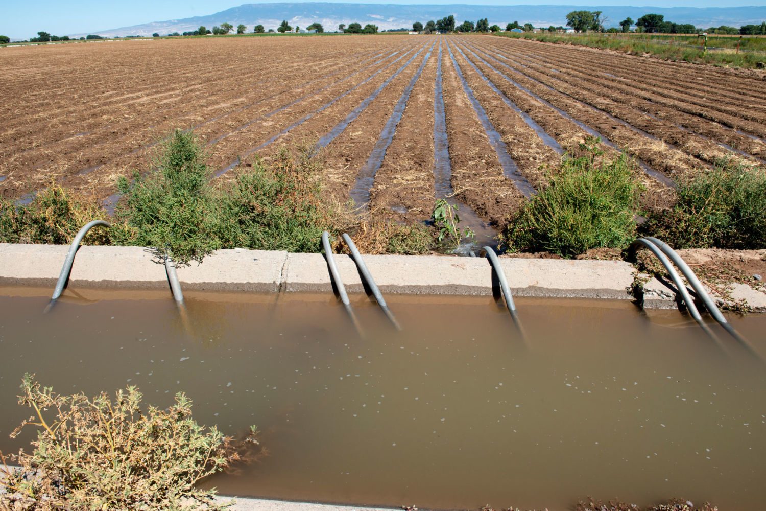
A field in Colorado’s Grand Valley using flood irrigation. This is the cheapest, most common form of irrigation in the area, but it is also the least efficient, using more water than drip irrigation or sprinklers.
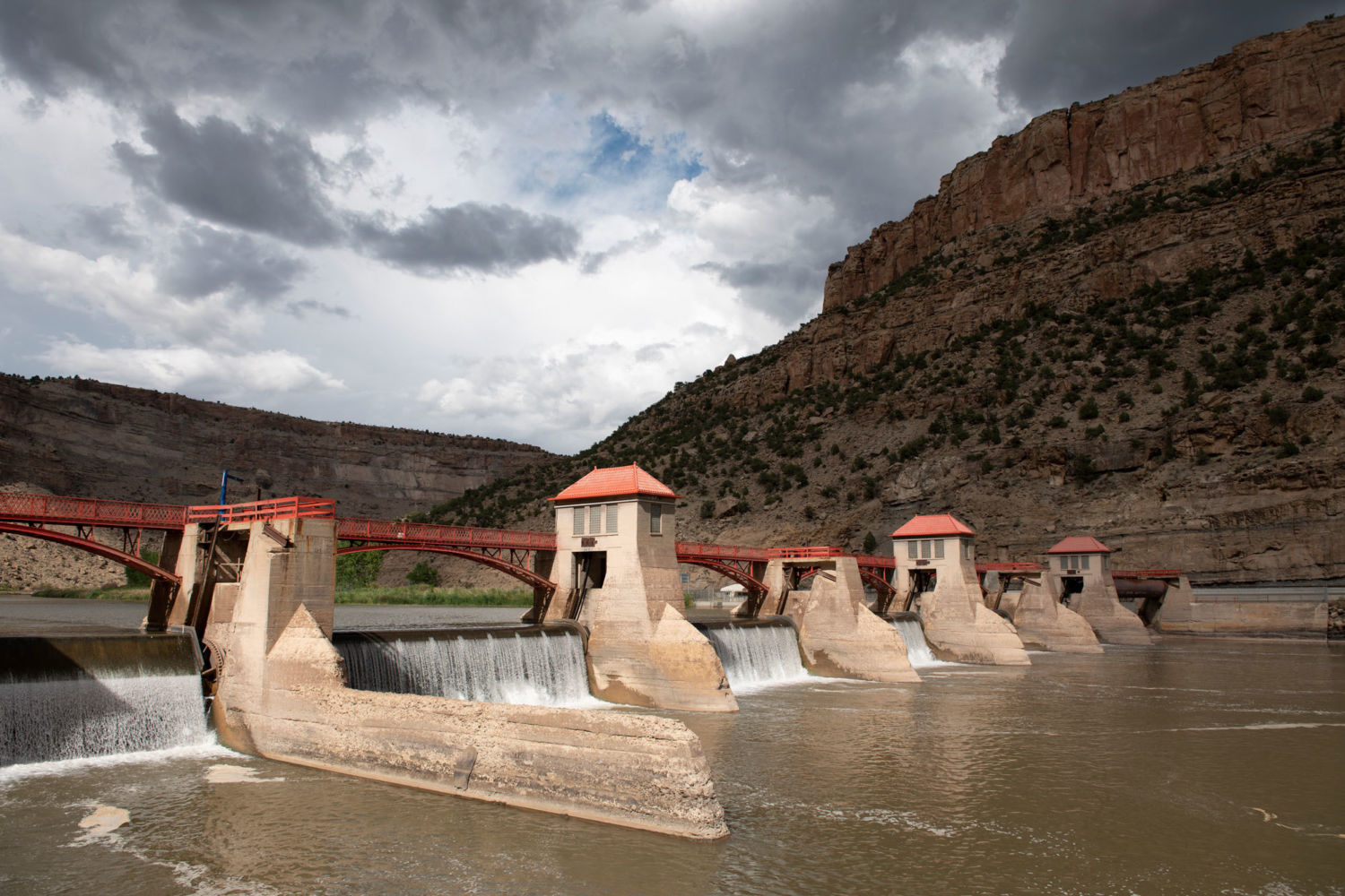
The Grand Valley Diversion Dam, completed in 1916, channels water from the Colorado River to western Colorado’s peach orchards and vast agricultural fields.
To conserve water, some farmers in the Grand Valley have turned off their irrigation pipes and let their fields go fallow in exchange for monetary compensation.
Newly installed headgates divert Verde River water onto fields and allow farmers to control the flow remotely using their smartphones. The computerized equipment was funded by private companies in Phoenix.
Chip Norton runs a malt factory, Sinagua Malt, in Camp Verde, Arizona, which has created a market for barley, a crop that uses less water than traditional alfalfa. Singua sells its malt to local craft breweries.
The Verde River is a perennial desert river supplied by mountain springs in Arizona’s central highlands. It is a critical water source for the Phoenix metropolitan region, home to 4.7 million people.
Ted Wood (tedwoodphoto.com) is a photojournalist and multimedia producer based in Boulder, Colorado. He specializes in environmental and conservation stories, particularly in the western United States. His work has appeared in Vanity Fair, Smithsonian, Audubon, and dozens of other national and international publications. Wood is also the co-founder of The Story Group, a multimedia journalism company in Boulder.
With the Southwest locked in a 19-year drought and climate change making the region increasingly drier, water managers and users along the Colorado River are facing a troubling question: Are we in a new, more arid era when there will never be enough water?
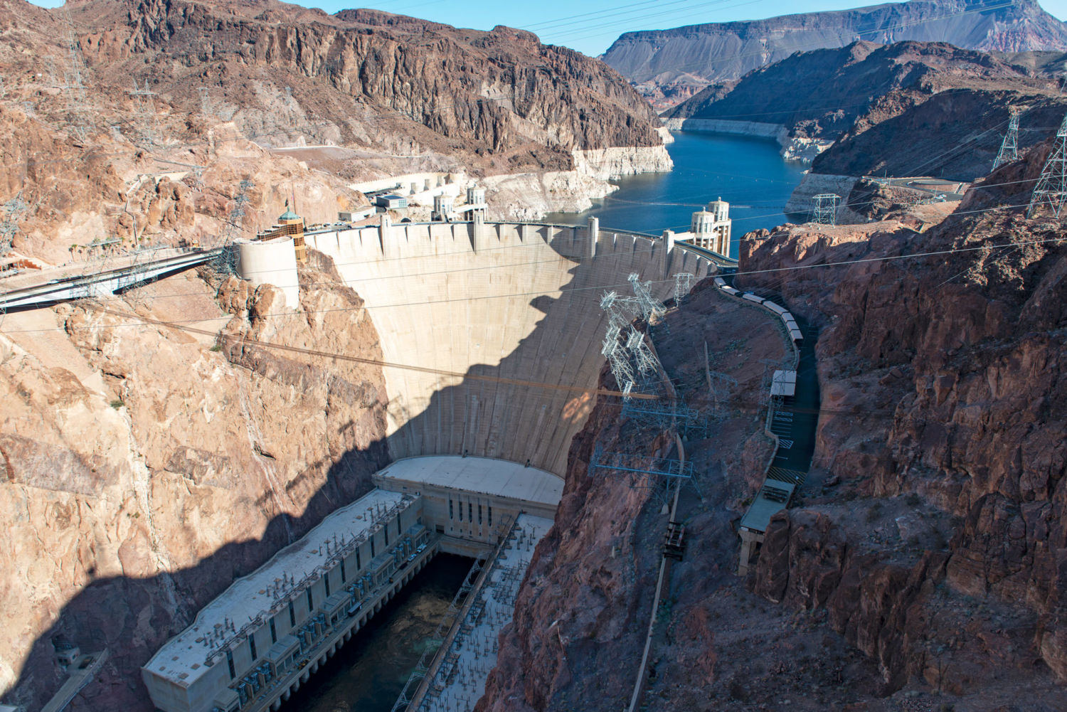
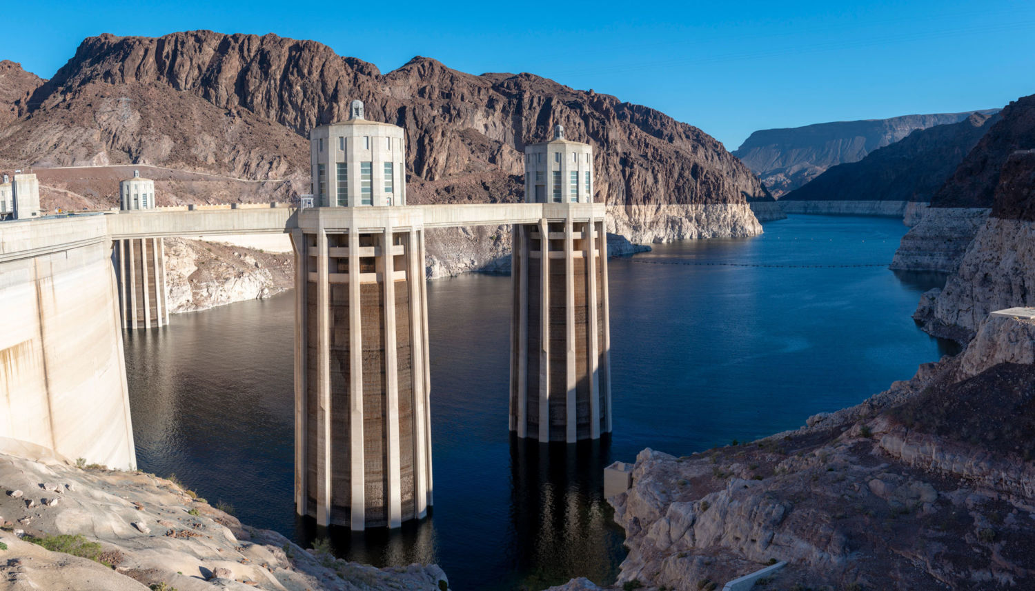
After two decades of drought, Lake Mead, which is impounded by Hoover Dam, is just 40 percent full. A “bathtub ring” visible along the edges of the lake show how far its water levels have dropped. PHOTO BY TED WOOD. SUPPORT FOR AERIAL PHOTOGRAPHS PROVIDED BY LIGHTHAWK
In the basement of the University of Arizona’s Laboratory of Tree-Ring Research, the fragrant smell of pine hangs in the air as researchers comb through the stacks of tree slabs to find a round, 2-inch-thick piece of Douglas fir.
They point out an anomaly in the slab — an unusually wide set of rings that represent the years 1905 to 1922. Those rings mean it was a pluvial period — precipitation was well above average — and so the trees grew far more than other years.
Researcher Will Tintor examines a cross-section of a bristle cone pine tree at the University of Arizona’s Laboratory of Tree-Ring Research, seeking clues about precipitation and climate trends during the tree’s lifetime. PHOTO BY TED WOOD
“In 1905, the gates opened and it was very wet and stayed very wet until the 1920s,” said David Meko, a hydrologist at the lab who studies past climate and stream flow based on tree rings. “It guided their planning and how much water they thought was available.”
The planning was that of the states that share the water of the Colorado River. Worried that a burgeoning California would take most of the water before it was fairly divvied up, representatives from the other Colorado River Basin states, presided over by U.S. Secretary of Commerce Herbert Hoover, came together in 1922 to develop an equitable apportionment. They looked at flow measurements and figured that the river contained an average of 15 million acre-feet. They divided the Colorado River states into two divisions – the upper basin and the lower basin, with the dividing line in northern Arizona near the Utah border. The upper basin states — Utah, Wyoming, Colorado, and New Mexico — agreed not to take more than a total of 7.5 million acre-feet and to allow the other half to flow south to the lower basin. The agreement they signed was called the 1922 Colorado River Compact, also known as the Law of the River.
The 1922 compact, though, is based on a premise that the tree rings in the University of Arizona lab now show is false. The river’s long-term average flow is about 12 to 15 million acre-feet, in a good year. Meanwhile, the lower basin states — Arizona, California, and Nevada — use 7.5 million acre-feet, and in 1922 no one factored in evaporative losses from the desert sun at the yet-unbuilt Lake Mead reservoir, which amount to another 1.2 million acre-feet, or the water taken up by plants. Nor did anyone factor in a subsequent 1944 treaty that requires the United States to provide 1.5 million acre-feet to Mexico. A conservative estimate on how much Colorado River water is actually used is 20 million acre-feet.
This over-appropriation is problem enough, but in recent years the river’s flow has been dwindling. The region is locked in a 19-year-long drought, the most severe in 1,250 years. And it may continue much longer. The tree ring data shows that there have been numerous multi-decadal or mega-droughts in the basin in the last 1,000 years. The prospect that drought could be the new normal for the region is creating a good deal of anxiety along the Colorado.
“Many water managers like me are struggling at not panicking,” said Mark Harris, general manager of the Grand Valley Water User’s Association in Grand Junction, Colorado. In his farm cap and jeans, Harris is a no-nonsense type, not given to hyperbole. This year, though, some “junior” water users on the Yampa River, a tributary to the Colorado, were told they would not get their water because others had priority, the first time that has ever happened, and late-season water flows near Grand Junction were near crisis levels. “The crunch is here,” Harris said. “It’s here, and it will stay here. We will never be out of the woods, we are in the woods forever.”
Another low-snow winter would trigger the first emergency declaration in the basin, forcing states to deal with water cutbacks.
Never has the question of “what will the winter be like?” loomed larger than it does this year in the Colorado River Basin. If it is anything like last year (when about two-thirds of the usual snow fell) and many other low snow years since 2000, it will trigger the first emergency declaration in the basin, which could force states to deal with cutbacks in the water they are appropriated. And even if it is a big snow year, it will likely only delay what now seems inevitable.
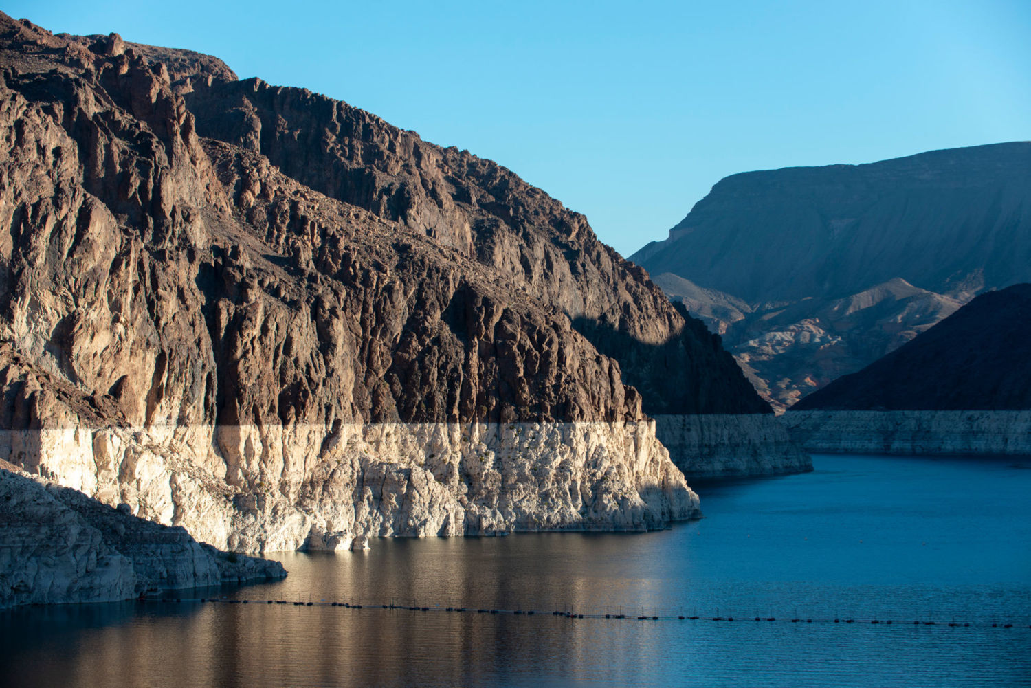
The last time Lake Mead was full was 1983. Since then it has slowly declined. It is now 40 percent full: 1,082 feet above sea level. It may never be full again, experts say. If it drops 7 feet, to 1,075 feet, it will trigger the first Tier 1 water cutbacks. A flyover reveals a giant white ring all the way around the lake’s 112-mile-long perimeter, dramatically showing how far water levels have dropped.
Mark Harris, general manager of the Grand Valley Water Users Association in Grand Junction, Colorado, is working with farmers in his community to reduce water usage. PHOTO BY TED WOOD
There are three levels of cutbacks. When Lake Mead falls to 1,050 feet, a Tier 2 crisis occurs, and Tier 3 at 1,025. At each level, states in the lower basin have to give up more of their water. Lake Mead would have already hit 1,075 feet and a First Tier declaration if it weren’t for the fact that farmers, ranchers, and many others have been working to avoid an emergency by keeping more water in the river through conservation efforts. For example, in 2017, state, federal, municipal, and private entities funded the purchase of 40,000 acre-feet from the Gila River Indian Community to be left in Lake Mead in perpetuity as part of a system conservation agreement.
Last August, the U.S. Bureau of Reclamation issued a report on the water future of the region. The agency’s predictions were sobering. By May of this year, the bureau forecast the level will dip just below 1,075 feet, and at the beginning of 2020, the level is expected to drop to 1,070. By the summer of 2020, the prediction is 1,050 feet, almost Tier 2. If these predictions come true, users will have to begin giving up their water allotments, starting with the most junior.
If water levels continue to drop, sinking below 1,050 feet, Hoover Dam — which impounds Lake Mead and provides power to millions of people in Southern California, Nevada, and Arizona — will stop generating electricity, as water levels will be too low to flow through it. And should Lake Mead keep dropping all the way to 895 feet, it will fall below the level at which water can be piped out — the dreaded “dead pool.” Moreover, because Lake Mead is funnel-shaped, the lower it gets the faster it drops. At some point there is the likelihood that the lower basin will force the upper basin to send water to meet its obligations — a compact call — something that’s never happened before.
A few wet years in a long dry spell would be critical these days to keep the Colorado from completely drying up.
All of this is uncharted crisis terrain. “If the drought is multi-decadal the system will fail,” said Jack Schmidt, a professor of watershed science at Utah State University. “But nobody knows what failure means.”
Arizona officials have a sense of it and are coming to grips with the reality. They are the most junior users in the Lower Basin and a Tier 1 shortage would mean Arizona would have to start cutting allocations to users. “If the current climate trend continues,” said Kathryn Sorensen, director of the Phoenix Water Services Department, “you could have ‘dead pool’ in four years. That’s worst case.” Should that happen, the whole region, she says, would be thrown into crisis.
If these were normal times, past droughts might give us a sense of what might be in store. The climate information stored in tree rings show that the longest drought in this region occurred in medieval times and lasted for 62 years — with no very wet years in between the dry ones. A few very wet years in a long dry spell would be critical on the Colorado these days to keep it from completely drying up.
But it may be even worse than that. This drought is unusually hot. “Temperatures keep going up,” said Meko, of the University of Arizona tree ring lab. “We keep breaking records year after year. It’s additional stress on the water system.” Meanwhile, the two driest years all the way back to the 1200s occurred in 1996 and 2002. “It’s a little worrisome to see the most extreme years right near the present,” he said.
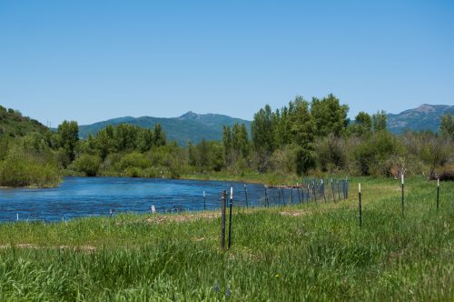
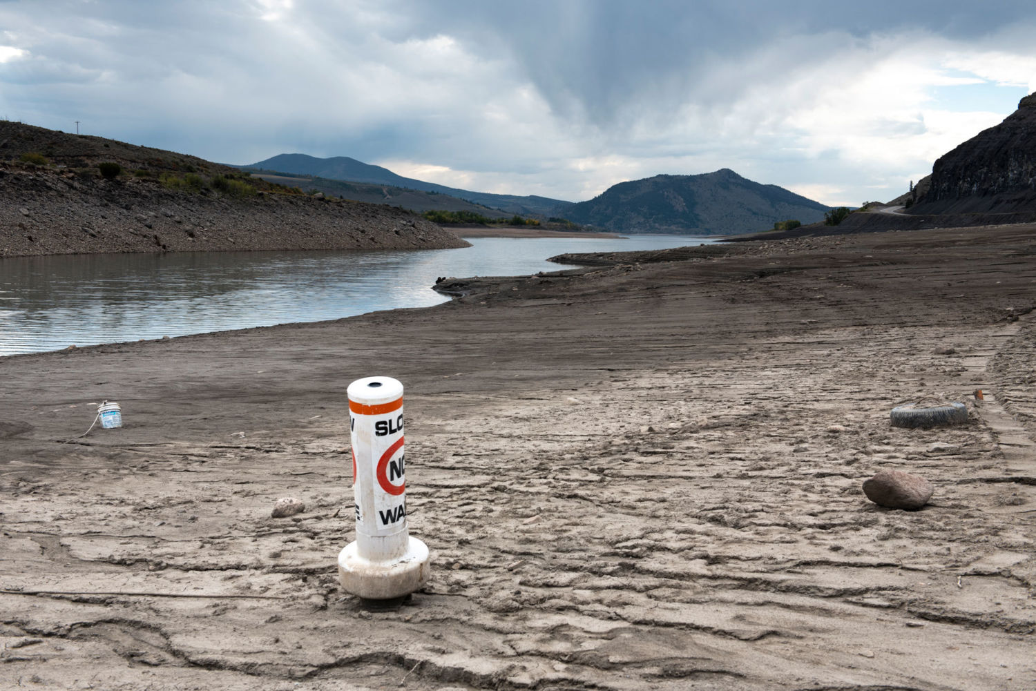
Water levels on the Yampa River near Steamboat Springs, Colorado dropped so far in 2018 that the river was closed to recreation.
“Droughts impacted by warmer temperatures will be more severe,” says Connie Woodhouse, who also studies climate at the tree ring lab. “A lack of precipitation is one thing. But when a drought happens and temperatures are warmer, the precipitation deficits are exacerbated. You have more evaporation, more ground heating, and it impacts the snowpack.”
From 2000 to 2014, flows in the river were 19 percent below the averages in the previous years, and a third of that loss was caused by high temperatures, according to researchers Jonathan Overpeck of the University of Michigan and and Brad Udall at the Colorado Water Insitute at Colorado State University, in an often-cited paper about the unprecedented nature of this drought and what it means for the future.
The biggest impact of high temperatures is something called runoff efficiency — the amount of stream flow that results from precipitation. Right now about 15 percent of the water in the snow in the watershed makes it into the river. The other 85 percent soaks into the ground, evaporates, or is taken up by plants. As it gets warmer, runoff efficiency is decreasing. Shorter winters mean the ground has less snow cover and is darker, so it warms up more and sooner, which means snow melts faster and more water evaporates and is taken up by plants in a longer growing season. The Colorado River Research Group, 10 veteran academics who study the Colorado, call this most alarming change to the physical environment.
The alarm is palpable among water managers throughout the Southwest. They see the writing on the wall.
Warmer temperatures also mean that of the precipation that does come, more of it will fall as rain instead of snow. The Colorado’s engineering infrastructure was built around the natural long-term storage that snowpack provides, but rain pulses quickly through the system.
Meanwhile, the rapid development of everything from housing developments to solar installations in the Southwest has created more dust particles which go airborne and settle on to the snow fields of the Rockies, five to seven times as much dust as was seen a century ago. The darker snow melts sooner and faster, a phenomenon that costs the river about 5 percent of its flow. And as the drought continues, there’s more dust from more dry ground and that creates more dust.
As the flow of the Colorado diminishes, more water users will be forced to turn to groundwater pumping.The news on that front, though, is also problematic. In a 2014 paper, researchers at the Global Institute for Water Security, which uses a satellite to measure large-scale changes in groundwater by measuring changes in gravitational pull, found that from 2004 to 2013, the loss of groundwater from pumping was 6.5 times greater than the total loss of water from Lake Powell and Lake Mead. “Everybody knows that groundwater will become progressively more important,” said Jay Famiglietti, the institute’s director. “The problem is groundwater is rapidly disappearing so we shouldn’t depend on it being there.”
However the biggest cloud looming over the Colorado River Basin is whether the region is entering a completely new era, a permanent change as opposed to a temporary one, caused by a planet being rapidly warmed by human activity. “Is this a drought or is this aridification of the Southwest and Colorado River Basin?” asked the University of Michigan’s Overpeck, who has long studied the Colorado.
Like Overpeck, many experts believe the drying up of the Colorado is being driven by a changing climate. “It’s going to get drier and drier,” he said. “It could mean a hell of a lot less water in the river. We’ve seen declines of 20 percent, but it could get up to 50 percent or worse later in this century.”
The Green Mountain Reservoir in Summit County, Colorado is an important source of water for the state’s Western Slope. It reached critically low levels in 2018, at just 46 percent capacity. PHOTO BY TED WOOD
If climate change is locked in, he said, what is going on now is not a new normal, but a stop along the way to a yet-drier new normal somewhere in the distant future. “In that case, every year will be a new reality,” he said. “The aridification of the Southwest will continue as long as we put greenhouse gases into the atmosphere. We need to stop burning fossil fuels and that will help stop the decline in the river flow.
“And even if we did that, there’s warming baked in,” he said. “It would continue for another decade and then stabilize. Then we will get the new normal. And it will be at that level of warmth for centuries.”
That’s why the alarm is palpable among water managers in the Southwest. They see the writing on the wall, and there are few skeptics about climate change among them. The plight of Cape Town, South Africa, which came to the brink of a water system crash last year, is on many people’s minds along the Colorado River.
This era of drying is especially serious because so much — some 40 million people and an economy that includes the world’s fifth largest, in California — is riding on the flow of the Colorado. The specter of a region facing an existential crisis because of a warming climate becomes more real every day. “If you can see it, you should plan for it,” Phoenix’s Sorensen said. “And I can see it.”
If water levels on Lake Mead drop another 32 feet, the Hoover Dam will stop generating electricity, cutting off power for millions of people in Southern California, Nevada, and Arizona. PHOTO BY TED WOOD
Farmworkers harvest yellow onions in Colorado’s Gunnison Valley. Agriculture uses about 80 percent of the Colorado River’s water to irrigate 6 million acres of crops. PHOTO BY TED WOOD
St. George, Utah is growing rapidly, with golf courses and subdivisions pushing into the desert. The city is seeking to build a new pipeline that would draw more Colorado River water from drought-stressed Lake Powell. PHOTO BY TED WOOD
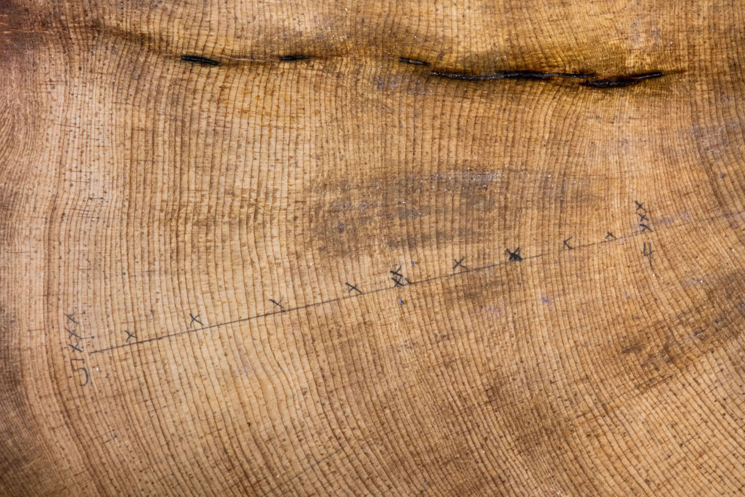
This tree ring core shows that the Colorado River Compact of 1922, which allocated water to Western states, was created in abnormally wet years, leading to overestimates of the water that would be available. PHOTO BY TED WOOD
A close-up of bristle cone tree rings with Xs marking 10-year spans. Information from tree rings give scientists data on precipitation and other climate information for each year of growth. PHOTO BY TED WOOD
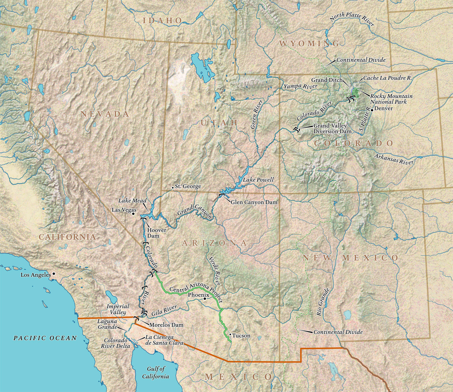
The Colorado flows 1,450 miles from its source in Colorado to the southwest, ending just short of the Gulf of California. MAP BY DAVID LINDROTH
Ted Wood (tedwoodphoto.com) is a photojournalist and multimedia producer based in Boulder, Colorado. He specializes in environmental and conservation stories, particularly in the western United States. His work has appeared in Vanity Fair, Smithsonian, Audubon, and dozens of other national and international publications. Wood is also the co-founder of The Story Group, a multimedia journalism company in Boulder.
As the Southwest faces rapid growth and unrelenting drought, the Colorado River is in crisis, with too many demands on its diminishing flow. Now those who depend on the river must confront the hard reality that their supply of Colorado water may be cut off.
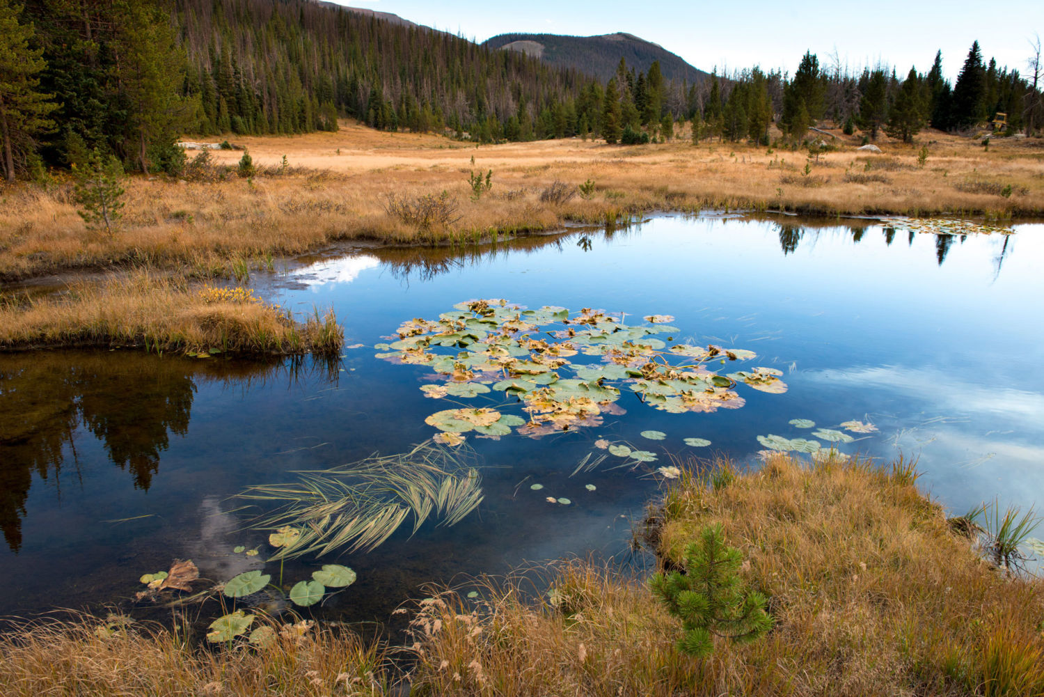
The beginnings of the mighty Colorado River on the west slope of Rocky Mountain National Park are humble. A large marsh creates a small trickle of a stream at La Poudre Pass, and thus begins the long, labyrinthine 1,450-mile journey of one of America’s great waterways.
Several miles later, in Rocky Mountain National Park’s Kawuneeche Valley, the Colorado River Trail allows hikers to walk along its course and, during low water, even jump across it. This valley is where the nascent river falls prey to its first diversion — 30 percent of its water is taken before it reaches the stream to irrigate distant fields.
The Never Summer Mountains tower over the the valley to the west. Cut across the face of these glacier-etched peaks is the Grand Ditch, an incision visible just above the timber line. The ditch collects water as the snow melts and, because it is higher in elevation than La Poudre Pass, funnels it 14 miles back across the Continental Divide, where it empties it into the headwaters of the Cache La Poudre River, which flows on to alfalfa and row crop farmers in eastern Colorado. Hand dug in the late 19th century with shovels and picks by Japanese crews, it was the first trans-basin diversion of the Colorado.
The headwaters of the Colorado River are in a marshy meadow in Rocky Mountain National Park. Photo: Ted Wood
The Colorado River gathers momentum in western Colorado, sea-green
and picking up a good deal of steam in its confluence with the Fraser,
Eagle, and Gunnison rivers. As it leaves Colorado and flows through
Utah, it joins forces with the Green River, a major tributary, which has
its origins in the dwindling glaciers atop Wyoming’s Wind River
Mountains, the second largest glacier field in the lower 48 states.
The now sediment-laden Colorado (“too thick to drink, too thin to plow” was the adage
about such rivers) gets reddish here, and earns its name – Colorado
means “reddish.” It heads in a southwestern direction through the slick
rock of Utah and northern Arizona, including its spectacular run through
the nearly 280-mile-long Grand Canyon, and then on to Las Vegas where
it makes a sharp turn south, first forming the border of Nevada and
Arizona and then the border of California and Arizona until it reaches
the Mexican border. There the Morelos Dam — half of it in Mexico and
half in the United States — captures the last drops of the Colorado’s
flow, and sends it off to Mexican farmers to irrigate alfalfa, cotton,
and asparagus, and to supply Mexicali, Tecate, and other cities and
towns with water.
While there are verdant farm fields south of the border here, it comes at a cost. The expansive Colorado River Delta — once a bird- and wildlife-rich oasis nourished by the river that Aldo Leopold described as a land of “a hundred green lagoons” — goes begging for water. And there is not a drop left to flow to the historic finish line at the Gulf of California, into which, long ago, the Colorado used to empty.
The Colorado flows 1,450 miles from its source in Colorado to the southwest, ending just short of the Gulf of California. Map by David Lindroth for Yale Environment 360
Nature, in fact, has been given short shrift all along the 1,450-mile-long Colorado. In order to support human life in the desert and near-desert through which it runs, the river is one of the most heavily engineered waterways in the world. Along its route, water is stored and siphoned, routed and piped, with a multi-billion dollar plumbing system — a “Cadillac Desert,” as Marc Reisner put it in the title of his landmark 1986 book. There are 15 large dams on the main stem of the river, and hundreds more on the tributaries.
The era of tapping the Colorado River, though, is coming to a close. This muddy river is one of the most contentious in the country — and growing more so by the day. It serves some 40 million people, and far more of its water is promised to users than flows between its banks — even in the best water years. And millions more people are projected to be added to the population served by the Colorado by 2050.
The hard lesson being learned is that even with the Colorado’s elaborate plumbing system, nature cannot be defied. If the over-allocation of the river weren’t problem enough, its best flow years appear to be behind it. The Colorado River Basin has been locked in the grip of a nearly unrelenting drought since 2000, and the two great water savings accounts on the river — Lake Mead and Lake Powell — are at all-time lows. An officially announced crisis could be at hand in the coming months.
Some scientists believe a long-term aridification driven by climate change may be taking place, a permanent drying of the West.
Meanwhile the Lower Basin states — Arizona, California, and Nevada — have, despite much debate, been unable to come up with a Drought Contingency Plan to keep water in Lake Mead below levels that would trigger a crisis and lead to mandatory cuts in water. And if the states do not agree on a plan by the end of this month, U.S. Bureau of Reclamation Commissioner Brenda Burman says she will step in and force hard decisions.
There are large, existential questions facing the 40 million people who depend on the river — there simply is not enough water for all who depend on it, and there will likely soon be even less.
Most of the water in the Colorado comes from snow that falls in the Rockies and is slowly released, a natural reservoir that disperses its bounty gradually, over months. But since 2000, the Colorado River Basin has been locked in what experts say is a long-term drought exacerbated by climate change, the most severe drought in the last 1,250 years, tree ring data shows. Snowfall since 2000 has been sketchy — last year it was just two-thirds of normal, tied for its record low. With warmer temperatures, more of the precipitation arrives as rain, which quickly runs off rather than being stored as mountain snow. Many water experts are deeply worried about the growing shortage of water from this combination of over-allocation and diminishing supply.
Water levels in Lake Mead at the Hoover Dam in Nevada have hit an all-time low.
There is tree ring data to show that multi-decadal mega-droughts have occurred before, one that lasted, during Roman Empire times, for more than half a century. The term drought, though, implies that someday the water shortage will be over. Some scientists believe a long-term, climate change-driven aridification may be taking place, a permanent drying of the West. That renders the uncertainty of water flow in the Colorado off the charts. While not ruling out all hope, experts have abandoned terms like “concerned” and “worrisome” and routinely use words like “dire” and “scary.”
“These conditions could mean a hell of a lot less water in the river,” said Jonathan Overpeck, an interdisciplinary climate scientist at the University of Michigan who has extensively studied the impacts of climate on the flow of the Colorado. “We’ve seen declines in flow of 20 percent, but it could get up to 50 percent or worse later in this century.”
Even in rock-ribbed conservative areas, those who use the water of the Colorado say they are already seeing things they have never seen before — this year state officials in Colorado cut off lower-priority irrigators on the Yampa River, a tributary of the Green, and recreation had to be halted, for example — and have grudgingly come to believe “there is something going on with the climate.”
If water cuts are mandated, some states will be required to send others their allotted water, whether they have it to spare or not.
As the authors of a 2015 study on the region’s climate future put it: “Our results point to a remarkably drier future that falls far outside the contemporary experience of natural and human systems in Western North America, conditions that may present a substantial challenge to adaptation.”
So there are conventions and meetings and papers being written throughout the Colorado Basin, seeking an agreeable adaptive future for a river in crisis. One of the big rubs in an incredibly complex debate is this: In 1922, California was booming and helping itself to an increasing share of the water, while other states were growing far more slowly. The other basin states wanted to assure their share before California could suck it up and, with guidance from then-Secretary of Commerce Herbert Hoover, created a Colorado River Compact that divvied up 15 million acre-feet of water — 7.5 million to the Upper Basin States and the same amount to Lower Basin States.
It’s well known now that this Law of the River was a product of irrational Manifest Destiny exuberance, a false premise based on unrealistic projections, because it was signed in one of the wettest periods on the river in centuries. Yet the actual amount apportioned among the states is more than 16 million acre-feet, 1.2 million acre-feet over the too-optimistic apportionment. These extravagant numbers are baked into the system, something known officially as a “structural deficit.”
St. George, Utah has been growing rapidly, with subdivisions and golf courses pushing into the desert. Its population has grown from 20,000 to 150,000 in the last 20 years. Photo by Ted Wood
Support for Aerial Photographs provided by Lighthawk
This winter is make or break for the short term. A crisis is underway — record low flows were seen throughout last summer and fall. Another low- snow winter could light the fuse of a major crisis — an escalating crescendo of emergencies ending in a “compact call” when the lower basin states call on the upper basin states to send them their legally mandated allotment of water — whether they have it to spare or not. All of the players along the river are jockeying for “water security,” an oft-heard term in the region these days.
Cities from Tucson, Arizona, to St. George, Utah, to Denver are booming and need more water to keep growing. Municipal officials across the basin are apprehensive about the future of their growth economy in a time of an increasing likelihood of limits.
Another friction point is the fact that the Upper Basin States — Wyoming, Colorado, New Mexico, and Utah — still have “paper water,” meaning water owed to them by the 1922 compact, which they have not yet taken out of the river. And while many experts say no new straws should be dipped into the river to suck more water out, even if a state is entitled, there are plans afoot to do just that, setting up even more contention and wranglings.
Speculators are quietly buying up farms with water rights and holding them for the day that the price of water soars.
The future of farms and ranches that depend on Colorado River water is most uncertain. Agriculture uses about 80 percent of the Colorado’s flow to irrigate 6 million acres of crops, the largest share of which is alfalfa grown to feed cattle; cities use just 10 percent. While agriculture’s rights are senior — it staked the first claims and so, by law, is the last to lose its water in a crunch — if the going gets tough and cities start running out of water, political and economic clout would favor the millions of people who live there. In that case, agriculture would start losing some of its allotment, either willingly or unwillingly.
“You don’t have to be a rocket scientist to see that there is going to be pressure on your water,” says Mark Harris, general manager of the Grand Valley Water Users Association, a group of irrigators in western Colorado trying to adapt to a new era. “We have a target on our back.” Dewatering agriculture could lead not only to the buying and drying of farms, but the collapse of many small towns whose raison d’être is growing food.
And then there is the recreation industry, a $26 billion part of the Colorado River economy. Last year, raft companies had to reduce their season and cut back the number of trips on the river because of diminished flows.
Meanwhile, speculators and investors have waded into this complex “Chinatown”-like scenario, and are playing a quiet, though growing, role. Hedge funds and other interests, a breed of vulture capitalists, are quietly buying up farms with water rights, and holding them for the day things become more dire and the price of an acre-foot of water soars.
The Colorado flows through Castle Valley, near Moab, Utah.
Lastly are the natural attributes of the Colorado River. The needs of fish, wildlife, and native flora have always been at the bottom of the priority list, lost to the needs of booming cities and thirsty crops. That’s changing, as a growing number of people and organizations are working to carve out a future for a more natural river — from the sandy beaches of the Grand Canyon, to the endangered fish along the river’s length, to the birds and jaguars of the Colorado River Delta in Mexico.
The bill for a century of over-optimism about what the river can provide is coming due. How the states will live within their shrinking water budget will depend on how severe the drought and drying of the West gets, of course. But however the climate scenario plays out, there is a good deal of pain and radical adaptation in store, from conservation, to large-scale water re-use, to the retirement of farms and ranches, and perhaps an end to some ways of life. Worst case, if the reservoirs ever hit “dead pool” — when levels drop too low for water to be piped out — many people in the region could become climate refugees.
“I hate to use the word dire, because it doesn’t do justice to the good-thinking people and problem solvers that exist in the basin, but I would say it is very serious,” said Brad Udall, a senior scientist at the Colorado Water Institute. “Climate change is unquantifiable and puts life- and economy-threatening risks on the table that need to be dealt with. It’s a really thorny problem.”
A farmer in Grand Junction, Colorado, works his alfalfa field, which is irrigated with water diverted from the Colorado River. To reduce water usage, some farmers are leaving their fields fallow in exchange for monetary compensation. PHOTO BY TED WOOD
Kayakers on the Green River, a main stem of the Colorado, at the Gates of Lodore in northwest Colorado. Low water levels have forced some bans on recreational uses. PHOTO BY TED WOOD
A white ring around the 112-mile perimeter of Lake Mead shows how far water levels have dropped because of drought conditions that have persisted since 2000. PHOTO BY TED WOOD
Development is mushrooming along Colorado’s Front Range north of Denver, with the water needs of the new communities being met by diversions from the Colorado River. PHOTO BY TED WOOD
The Colorado River passes through the Hualapai Indian Reservation in northern Arizona, west of Grand Canyon National Park. PHOTO BY TED WOOD
Farmworkers pick sweet corn in Colorado’s Gunnison Valley. The Gunnison is a major tributary of the Colorado, which it joins at Grand Junction. TED WOOD
The 80-mile-long All-American canal takes water from the Colorado River to California’s Imperial Valley, a major sources of U.S. fruits, vegetables, and cotton. PHOTO BY TED WOOD
The Morelos Dam at the U.S.-Mexico border is the last major diversion of Colorado River water, channeling water for the city of Mexicali and agricultural users in Mexico. PHOTO BY TED WOOD
The Colorado River once flowed into the Gulf of California, but now its dried-up delta is a desiccated landscape of old river channels, salt tidal flats, and mineral deposits. PHOTO BY TED WOOD
Ted Wood (tedwoodphoto.com) is a photojournalist and multimedia producer based in Boulder, Colorado. He specializes in environmental and conservation stories, particularly in the western United States. His work has appeared in Vanity Fair, Smithsonian, Audubon, and dozens of other national and international publications. Wood is also the co-founder of The Story Group, a multimedia journalism company in Boulder.
Fen soils are made of a rich, organic peat material that take thousands of years to form and require a constant groundwater source to survive. At the Rocky Mountain Fen Research Project, scientists transplanted fen soils from another site to the “receiver” site south of Leadville where they restored a groundwater spring to sustain the transplanted soils. Photo by Sarah Tory/Aspen Journalism
LAKE COUNTY — One morning last month, Brad Johnson arrived at a patch of rippling yellow grasses alongside U.S. 24, a few miles south of Leadville in the upper Arkansas River valley. Sandwiched among a cluster of abandoned ranch buildings, a string of power lines and a small pond, it is an unassuming place — except, of course, for its views of 14,000-foot peaks rising across the valley.
But appearances can be deceiving. The rather ordinary-looking property was a fen, which is a groundwater-fed wetland filled with organic “peat” soils that began forming during the last ice age and that give fens their springy feel.
“It’s like walking on a sponge,” Johnson said, marching across the marshy ground, stopping every now and then to point out a rare sedge or grass species.
Johnson was visiting the fen to record groundwater measurements before winter sets in. As the lead scientist for the Rocky Mountain Fen Research Project, Johnson is part of an effort spearheaded and paid for by Aurora Water and the Board of Water Works of Pueblo to study new ways to restore fens.
The research could help facilitate future water development in Colorado, such as the potential Whitney Reservoir project, part of a 20-year water-development plan from Aurora Water and Colorado Springs Utilities for the upper Eagle River watershed. The utilities, working together as Homestake Partners, are looking at building the reservoir in the Homestake Creek valley, south of Minturn, in an area that probably contains fens, which could hinder the project.
Aurora and Colorado Springs are working together on the reservoir project, and Aurora and Pueblo are funding the fens research. Although the Whitney project is not directly tied to the fen project, if the research efforts are successful, they could help Aurora and Colorado Springs secure a permit approval for the reservoir — and maybe alter the fate of an ecosystem.
Brad Johnson, a wetland ecologist for the Rocky Mountain Fen Research Project, takes groundwater measurements at the research site near Leadville, while his dogs, Katie and Hayden watch. The cities of Aurora and Colorado Springs are looking to develop additional water in Eagle County and divert it to the Front Range. Photo by Sarah Tory/Aspen Journalism
Irreplaceable resources
If you’ve walked through Colorado’s high country, chances are you’ve walked by a fen, which are among the state’s most biodiverse and fragile environments. To protect fens, the U.S. Fish and Wildlife Service and the Environmental Protection Agency drafted a “fen policy” in 1996. The policy, amended in 1999, determined that fens are irreplaceable resources because their soils take so long to regenerate. “On-site or in-kind replacement of peatlands is not possible,” the policy reads.
Inside the Fish and Wildlife Service, however, a different interpretation emerged. “Irreplaceable” became “unmitigable,” making it difficult or impossible to secure approval for any project that would severely impact fens.
Although Johnson is in favor of fen conservation, the Fish and Wildlife Service’s “unmitigable” interpretation bothered him. Not only was that status not supported by the fen policy itself, he believes saying “no” all the time is not in the best interest of fens.
“My fear is that if we don’t have the means of mitigating our impacts, we’ll just impact them,” he said.
Eventually, Johnson believes, conservationists will have to make some concessions to development. But by researching better mitigation techniques, he hopes he can help preserve fens in the long run.
Brad Johnson, the lead scientist for the Rocky Mountain Fen Research Project, at the project site in the Upper Arkansas River Valley. Launched by two Front Range water utilities in 2003, the project is studying a new way to mitigate potential impacts to fens, an ecologically rich and fragile wetland found throughout Colorados’ high country. Photo by Sarah Tory/Aspen Journalism
An organ transplant
For water utilities, fens have been particularly troublesome. Fens like to form in high-alpine valleys, the places best suited for dams and water reservoirs that take water from rivers mostly on the Western Slope and pump it over the mountains to supply the Front Range’s growing population.
But the fen policy has stymied many of the utilities’ plans to develop new water projects. Those defeats helped spur Front Range utilities to start researching new mitigation strategies that would help them comply with environmental regulations — and get around the fen policy.
“They wanted to figure out how to do this right so they could actually permit their projects,” Johnson said.
Through the fen-research project, Aurora and Pueblo saw an opportunity to address the fen policy’s requirement that a project offset unavoidable impacts to a fen by restoring an equivalent amount of fen elsewhere.
Since the fen project began 16 years ago, Aurora and Pueblo have invested $300,000 and $81,500 in the research, respectively. More recently, other funders have joined the effort, including Denver Water, Colorado Springs Utilities at about $10,000 each and the Colorado Water Conservation Board ($100,000).
After a number of fits and starts, Johnson three years ago settled on a design for the research that would test whether it’s ecologically possible to transplant fen soils from one location to another. First, Johnson restored the original groundwater spring at the old Hayden Ranch property. Then, he and a team of helpers removed blocks of soil from another degraded fen site and reassembled them, like an organ transplant, at the “receiver” site, where the restored spring now flows through veinlike cobble bars and sandbars, feeding the transplanted fen.
One of several potential dam sites on lower Homestake Creek. The resulting reservoir would flood fens upstream. The existing dam on upper Homestake Creek is visible in the distance. Photo by Brent Gardner-Smith/Aspen Journalism
Positive signs
It’s still too early to know whether the project could eventually serve as a fen-mitigation strategy for a new reservoir, but Johnson is optimistic about the results thus far. In 2017, after just one growing season, he was shocked to discover 67 different plant species growing at the transplanted fen site — compared with just 10 at the donor site. He was thrilled by the news. The data showed that the transplanted fen ecosystem is thriving.
That’s good news for utilities such as Aurora, too.
A week after Johnson visited the Rocky Mountain Fen Project site, Kathy Kitzmann gave a tour of the wetland-filled valley formed by Homestake Creek where Aurora and Colorado Springs are planning to build Whitney Reservoir.
Kitzmann, a water resources principal for Aurora Water, drove down the bumpy, snow-covered road that winds along the valley bottom, pointing to the two creeks that would — along with Homestake Creek and the Eagle River, near Camp Hale — help fill the reservoir. A pump station would send the water upvalley to the existing Homestake Reservoir and then through another series of tunnels to the Front Range.
In the lower part of the valley, Kitzmann stopped at the first of four potential reservoir sites — ranging in size from 6,000 acre-feet to 20,000 acre-feet — that the utilities have identified for the project and the wetlands it would inundate.
“You can sort of see why it wouldn’t be the best, just given the vastness of the wetlands,” Kitzmann said.
Farther along, the valley becomes more canyonlike, with higher rocky walls and fewer wetlands — probably offering a better reservoir site, said Kitzmann, although the permitting agencies won’t know for sure until they complete their initial feasibility studies.
A wetland area along Homestake Creek in an area that would be flooded by a potential Whitney Reservoir. The cities of Aurora and Colorado Springs are looking to develop additional water in Eagle County and divert it to the Front Range. By Brent Gardner-Smith/Aspen Journalism
Drilling application
In June, Aurora and Colorado Springs submitted a permit application to the U.S. Forest Service to perform exploratory drilling and other mapping and surveying work, but the agency has not yet approved the permit.
Potential fen impacts are just one of several environmental hurdles facing the project. One of the Whitney alternatives would encroach on the Holy Cross Wilderness. Aurora and Colorado Springs have proposed moving the wilderness boundary, if necessary, to accommodate the reservoir.
It’s also likely that the wetlands in the Homestake Valley contain fens, but until the utilities conduct wetland studies around the proposed reservoir sites next summer, the scope of the impacts remains uncertain.
Environmental groups including Colorado Headwaters, a nonprofit, oppose the Whitney Reservoir project, arguing that it would destroy one of the state’s most valuable wetlands, as well as an important habitat for wildlife and rare native plants.
In the meantime, Aurora is hopeful that Johnson’s research might one day help solve some of the environmental problems around new water development. “We are excited about proving that you can restore and rehabilitate fens,” Kitzmann said.
The dam in the Eagle River headwaters that forms Homestake Reservoir, which diverts water to the Front Range. Photo by Brent Gardner-Smith/Aspen Journalism
Inevitable impacts
But is a transplanted fen as good as not touching one in the first place?
A Fish and Wildlife Service spokesperson said fens are still designated a “Resource Category 1,” which means that the appropriate type of mitigation is avoidance, or “no loss.”
White River National Forest supervisor Scott Fitzwilliams echoed the spokesperson’s statement, noting that land managers place a high emphasis on protection for fens: “It’s really hard to replace a wetland in these high elevations.”
Johnson, asked whether he was worried that his research into fen mitigation might end up facilitating the kinds of projects that are most damaging to fens. He sighed. “I’m sensitive to that,” he said.
But like it or not, Johnson believes that more impacts to fens are inevitable. As Colorado’s population grows, water utilities will have to build new reservoirs, the state will need new roads and ski resorts will want to expand.
“I can’t argue with whether they should get built,” he said. “I’m just a wetlands guy.”
Editor’s note: Aspen Journalism collaborates with the Vail Daily and other Swift Communications newspapers on coverage of water and rivers. This story appeared in the Nov. 18 print edition of the Vail Daily.
This story was supported by The Water Desk and The Walton Family Foundation.
Gross Reservoir, in Boulder County, holds water diverted from the headwaters of the Colorado River on the West Slope. The reservoir is part of Denver Water’s storage system. Credit: Jerd Smith
Water sufficient for more than 1 million homes on the Front Range could be lost, and thousands of acres of farm land on both the Eastern and Western Slopes could go dry, if the state can’t supply enough water from the drought-stricken Colorado River to downstream states as it is legally required to do, according to a new study.
Among the study’s key findings:
In the next 25 years, if the state does nothing to set more water aside in Lake Powell, the Front Range could lose up to 97 percent of its Colorado River water.
All but two of the state’s eight major river basins, under that same “do nothing” scenario, also face dramatic water cutbacks.
If Colorado, Wyoming, Utah and New Mexico increase their water use by as little as 11.5 percent, as predictions indicate they will by 2037, the risk of a legal crisis spurring such cutbacks on the river doubles, rising from 39 percent to 78 percent, under one scenario, and 46 percent to 92 percent under another.
“Every water user in every river basin [linked to the Colorado] faces some risk,” said Andy Mueller, general manager of the Glenwood Springs-based Colorado River Water Conservation District, one of the sponsors of the Colorado River Risk Study, as it is known. The Durango-based Southwestern Water Conservation District also sponsored the work.
A worker cultivates the soil in a Herman Produce peach orchard near Palisade on Nov. 18, 2019. Credit: Ed Kosmicki
“That’s an important takeaway because when you begin to realize the extent of potential damage, whether it is on the West Slope or the Front Range, then we all come to the realization that we have a shared risk,” Mueller said.
Under the 1922 Colorado River Compact, the river’s supplies are divided between the four Upper Basin states (Wyoming, Utah, Colorado and New Mexico) and three Lower Basin states (California, Nevada and Arizona). The compact dictates that cities and farmers in the Upper Basin whose water rights were obtained after the compact was signed would have to give up some or all of their water to the Lower Basin if there isn’t enough water in Lake Powell to meet the terms of the compact. Colorado uses the most water of all the Upper Basin states and therefore faces the most risk.
The study was conducted by Boulder-based Hydros Consulting and released in June. It looked at different scenarios for the way river conditions and reductions to diversions could play out, as well as ways to reduce the risk cities and farms face, including spreading the cutbacks proportionately among all the river basins, something that isn’t typically done.
Scare tactics
Front Range water utilities are wary of the study and have begun a new round of analysis to determine if they agree with the results.
Alex Davis is a water attorney for the City of Aurora. At a recent forum on the risk study, she said that the chances of a Colorado River crisis were being exaggerated. And the study acknowledges that under some scenarios the risk of such a legal crisis is low.
“All of this talk is helpful to get people to think about the issue, but it also seems like a bit of scare tactics. If the Lower Basin states did try to do something, there would be a whole number of reasons [they would not get far],” she said.
Including the fact that they continue to overuse their share of the river by about 1.2 million acre-feet a year. Before Colorado and its northern neighbors were asked to cut back, the Lower Basin would have to do additional cutbacks as well, she said.
Who loses the most if doomsday strikes the Colorado River?
If drought and climate change continue to sap the river’s flows, and a legal crisis erupts with downstream states, six of the state’s eight major river basins could be forced to give up water. The Front Range and Eastern Plains are most vulnerable if shortages hit the river downstream and could lose as much as 97 percent of their Colorado River supplies. Credit: Chas Chamberlin
West meets east
Though the Colorado River flows west, and originates in Colorado’s Never Summer Mountains in Rocky Mountain National Park, a large chunk of its flows, more than 530,000 acre-feet, are pumped east over the Continental Divide to the state’s Front Range cities, including Denver, Colorado Springs, Pueblo, Boulder, Fort Collins and Broomfield, among others. That’s enough water to supply 1.06 million homes or to irrigate more than one-half million acres of crops.
Because these water users built their tunnels and reservoirs decades after the 1922 Compact was signed, they could be among the first to be cut off. Denver’s largest storage pool, Dillon Reservoir, was completed in the 1960s. East Slope cities and farmers would lose 97 percent of their Colorado River supplies if those diversions were completely shut down, according to the study.
“You have to start with the fact that 50 percent of the water on the Front Range comes from the West Slope. Should the Upper Basin fail to meet its delivery obligation, half of water use on the Front Range would be curtailed. That’s an enormous problem,” said Brad Udall, a senior climate and water scientist at Colorado State University’s Colorado Water Center.
Other parts of the state also face risk, some more than others. The Yampa River Basin, home to Steamboat Springs, would lose slightly more than 70,000 acre-feet of water, or 30 percent of its Colorado River supplies.
The Gunnison Basin, where agriculture controls historic water rights that pre-date the compact, is better protected, with the potential to lose just over 57,000 acre-feet of water, or 10 percent of its share of the river.
But a large swath of the southwestern part of the state would also be hard hit. Despite the historic farm water rights in this region, several small communities and irrigation districts built reservoirs after the compact was signed, just as cities did on the Front Range, meaning that those stored water supplies are also at high risk. In this basin, 178,000 acre-feet of water, roughly 36 percent of its Colorado River supplies, could be lost, according to the study.
The likelihood of ongoing drought and hotter summers only deepens the uneasiness over the river’s ability to produce the amount of water the state once relied on.
“We don’t expect to see cooler temperatures in the future, we expect to see warmer temps,” Mueller said. “If that is true, then we have to plan on reduced water supplies within our state.”
Blue Mesa Reservoir is Colorado’s largest reservoir, 20 miles long with a surface area of over 14 square miles. It was created by the damming of the Gunnison River by Blue Mesa Dam in 1966 as part of the Colorado River Storage Project, helping control the flow of water into the Colorado River. Credit: Dean Krakel
Saving more water?
The study comes as the Colorado Water Conservation Board (CWCB), the lead water policy agency in the state, is examining whether to launch a massive, voluntary conservation program that would allow the state and its neighbors to save some 500,000 acre-feet of water and store it in a newly authorized drought pool in Lake Powell. The pool, to be used only by the Upper Basin states, could help protect Colorado and its neighbors if drought and climate change continue to sap the river’s flows.
Michelle Garrison is a modeler with the CWCB who has analyzed the study’s results. She said the scenarios it considered are important for comparative purposes and may help the West Slope and Front Range collaborate on any water cutbacks, something that hasn’t always occurred in the past.
“It’s a tough one,” she said. “The hydrology in the Colorado River has always been extremely variable and it’s predicted to become even more variable. But I’m really pleased to see them sharing their results.”
In places like the Yampa Basin, if the state cut back water use based strictly on prior appropriation, where water right dates determine who gets water first in times of shortage, Stagecoach Reservoir, the most significant storage pool in the valley, could be shut off because its storage rights date only to the 1980s. And residents would be hard pressed to cope if another long-term drought drained the river and their only source of stored water was no longer able to refill.
Kevin McBride is manager of the Upper Yampa Water Conservancy District, which owns Stagecoach. He, like dozens of other water managers across the state, is still contemplating the options. (Editor’s note: McBride serves on the board of Water Education Colorado, which houses Fresh Water News.)
“Generally being safe from drought is what it’s all about,” McBride said. “But how do you get there?
“It’s complicated and it comes down to how it’s done.”
McBride and others on the West Slope are asking for another round of modeling that would examine more equitable ways to cut back water use, so that no one takes the brunt of the reductions.
With insurance, or without?
Others have suggested that the state should let the rules embedded in the 1922 Compact and Colorado’s water rights system play out, rather than creating an expensive, legally complex water conservation program.
Anne Castle is a senior fellow at the University of Colorado’s Getches-Wilkinson Center for Natural Resources who specializes in Colorado River issues. Going without a major conservation program carries its own set of very high risks, such as decades of expensive lawsuits or unplanned water shortages.
Over the next several months, the state will continue to examine how best to protect its Colorado River water as part of drought planning work it is engaged in with the other Upper Basin states. Late next year, all Colorado River Basin states will begin negotiating a new set of operating guidelines for the entire river system, designed to bring it back into balance and slash the risk of major cutbacks.
“Truly one of the points of this risk study is to make sure that anyone who is at risk understands the risk,” Mueller said. “If you’re a water planner, it may set off some alarm bells. But we don’t want people to panic. The hope is people will look at this and say, ‘Our community is at risk…what are we going to do about it?’”
Jerd Smith is editor of Fresh Water News. She can be reached at 720-398-6474, via email at jerd@wateredco.org or @jerd_smith.
This story originally appeared on Fresh Water News, an independent, non-partisan news initiative of Water Education Colorado. WEco is funded by multiple donors. Its editorial policy and donor list can be viewed at wateredco.org.
The construction of dams on rivers worldwide has stopped the natural flow of sand and silt to the sea—resulting in coastal wetland loss and disappearing beaches—as well as preventing fish from reaching vital spawning grounds. But when the decision is made to remove a dam it can be remarkably challenging. Just ask the people of Ventura, California, who’ve been trying for 20 years—and are not much closer to ditching a dam that supplies no water but packs a lot of downsides—and risk.
Bulrush and reeds grow on the Matilija Reservoir in Ventura County, California that’s filled with sediment. The scissors and dashed line grafitto have made the dam an icon in the removal movement. Photo by Frani Halperin/H2O Media, Ltd.
Ventura, Calif.—It’s a flawless sunny day in Ventura, California. In the coastal city, north of Los Angeles, surfers bob on boards watching the swells for the ideal wave. If you want a long ride, here at Surfers’ Point, where the Ventura River meets the ocean, is the place you want to be. It’s a classic California point break that creates waves surfers gravitate to up and the down the coast.
It’s a favorite spot for Paul Jenkin, who’s been surfing this break for over 30 years. But today he’s not here waiting for the perfect wave; he’s waiting for a better beach—or at least the beach that used to be here.
Jenkin is the campaign coordinator for the Surfrider Foundation, a nonprofit organization focused on the protection and enhancement of the world’s oceans, waves, and beaches. For 20 years he’s been working to restore the natural supply of sand and gravel to this cobbled beach that’s seen its parking lot and bike path crumble into the ocean. He says one of the concerns at Surfrider is that with sea level rise, recreational beaches are going to disappear. “We’re going to lose our surf spots and lose a place just to put a towel down on the sand.”
Rising sea levels along with coastal development are some of the threats to Surfers’ Point, but the real culprit is some 16 miles away in a mountain canyon far above the city—the Matilija Dam.
Matilija Dam
Matilija Dam was built in 1947, driven by farmers and ranchers in the nearby Ojai Valley, who wanted it for flood control and water supply. Peter Sheydeyi, deputy director of Ventura County Watershed Protection District, the agency that owns the dam, says Matilija originally had 7,000 acre-feet of storage. But over the last 70 years it has completely filled with sediment—some 8 million cubic yards of sand and gravel—enough to fill 800,000 dump trucks—that no longer flows to the beach.
Matilija Reservoir has filled with sediment, allowing grasses to grow on its surface. Photo by Paul Jenkin (August 2019)
Matilija Dam had bad juju right from the start. The Army Corps of Engineers warned the Ventura County Flood Control District not to build it, saying the surrounding steep landscape of coastal sage scrub and oak woodland was highly erodible and would fill the reservoir with sediment.
Then, during its construction, it was discovered the concrete used in the dam had a condition that would weaken over time. The original structure was 198 feet tall but was notched down in the 1960s and ’70s to 168 feet due to safety concerns. Those safety concerns continue to this day because this is California, where earthquakes are always a possibility. In 2018, Matilija Dam received a “poor” rating for seismic risk in a review by state’s Division of Safety of Dams (DSOD).
Lastly, before Matilija Dam was built, the Southern California steelhead (Oncorhynchus mykiss) would come upriver to spawn. But because the fish can no longer migrate to their historic freshwater habitats to reproduce to maintain or grow their populations, the trout has been listed as endangered. Sheydeyi, who’s managing the Matilija Dam Ecosystem Restoration Project for the county says if the dam were removed it’s believed that a good population of the fish would return to the upstream watershed.
Cut here to empty contents
Given the numerous downsides—impeded fish migration, beach erosion, and seismic risk—not to mention that it provides no water supply—Matilija Dam has been slated for removal, and among the graffiti painted all around the dam is a dashed line with a giant pair of scissors suggesting, “cut here” to empty its contents. The artwork has become iconic in the movement to remove obsolete dams and was featured in the documentary DamNation.
But unleashing sediment that’s accrued for over 70 years is not something you can do without a lot of planning, studies—and money. In 2000, Jenkin formed the Matilija Coalition to bring together the many non-governmental organizations interested in removing the dam, such as CalTrout and Friends of the River, two statewide organizations that were focused on restoring native steelhead. The outdoor retailer Patagonia, which is headquartered along the Ventura River in the city, has been a huge backer of the effort. Also, the Open Rivers Fund (a program of Resources Legacy Fund with support from the William and Flora Hewlett Foundation that aids local community efforts to remove obsolete dams, modernize infrastructure, and restore rivers across the western United States) stepped in to help.
And now—20 years, several studies, and over $20 million later—they might finally have a solution. The current proposal is to drill two 12-foot holes at the base of the dam, and then, during a moderately sized rain event open them up to flush the fine sediments downriver. The county would then—potentially the following summer—dismantle the dam once the pressure load was released. Of the 8 million cubic yards in the reservoir it’s estimated that only 2 million cubic yards would move downstream. The rest would be stabilized in place and be restored with native vegetation that would become a permanent part of the landscape. Sheydeyi hopes that after the dam is gone the area will be a recreational destination with trails, which will allow people “to enjoy the cool waters during the late summer months at Matilija Creek.”
But before the flushing event happens however, improvements downstream would be needed. It’s estimated that the river would rise two to six feet in elevation once the dam is removed, so that will require two new bridges and two new levees—something that will likely take at least a decade and somewhere in the neighborhood of $150 million to complete. Then, they wait for rain, which given California’s recent drought cycles could be a while.
A lesson for other dams
What ultimately happens at Matilija might be a lesson for the hundreds of other California dams, sitting on creeks and streams that drain to the ocean. A study done by Cope M. Willis and Gary B. Griggs at the University of California, Santa Cruz, found that statewide about 25 percent of sand that would have been delivered to the coast is now blocked by dams. In Southern California, where beaches are a huge part of the economy, it’s 50 percent.
All that trapped sediment also means reservoir capacity is shrinking. Toby Minear, a researcher at that Cooperative Institute for Research in Environmental Sciences (CIRES) at the University of Colorado, Boulder, estimated in a 2009 paper that statewide, reservoirs have likely filled with 2.1 billion cubic meters of sediment, decreasing total reservoir capacity by 4.5 percent. About 200 reservoirs have likely lost more than half their initial capacity to sedimentation.
Surfers’ Point Bike Path, January 2019. Photo by Paul Jenkin
Climate change
As the number of wildfires and extreme storms increase with climate change it will likely cause more sediment to move into reservoirs, further shrinking their capacity. Sediment transport in this fire-flood scenario is accelerated because burnt material is highly erodible and ready to be swept down hillsides with heavy rains. Sheydeyi says the 2017 Thomas Fire caused another influx of sediment and led to the growth bulrushes and grasses growing on the reservoir’s surface.
The lack of sediment moving downriver combined with sea level rise will exacerbate problems already occurring along the coast such as flooding, cliff erosion, and threats to infrastructure. Beaches may seem static—that the sand just stays put—but it’s always in motion due to waves, wind, and tides. Winter waves have high energy that pulls sand offshore, making beaches narrower. In the summer, sand is carried back onto beaches, widening them again.
But this cycle only continues when there is a steady supply of sand. As sea levels rise a deficit of protective sand will expose cliffs and development to further erosion and flooding. Additionally, overbuilt shorelines mean that beaches lack the room to migrate inland to accommodate higher water. It’s in this context that, in 2011, a working group, including Surfrider, city planners, the California Coastal Conservancy, the State Coastal Commission, the Ventura County Fairgrounds, and others completed the first phase of what they call the first “managed shoreline retreat” project in the state of California, where infrastructure is moved back out of harm’s way in lieu of armoring the shore with seawalls and rock revetments.
In phase 1 of the Surfers’ Point Managed Shoreline Retreat a 70- to 100-foot-wide stretch of sand dunes was engineered, underneath which rests an 8-foot-thick layer of imported river cobble. On the surface native plants and driftwood anchor the dunes in place. The project has gained recognition for coastal management in response to climate change, has been featured in numerous case studies, and serves as a model of sustainable shoreline management in the era of rising seas, according to the California Coastal Conservancy.
Surfers’ Point Managed Shoreline Retreat. Photo by Frani Halperin/H2O Media, Ltd.
An epic ride
If the various stakeholders involved in the Matilija Dam removal are able to raise the needed funds, the necessary infrastructure is completed, and a series of drenching storms hit the area—just how much sand would replenish the beach?
Jenkin says the initial assessment was that around 30 percent more sediment would come out of the river during each storm event, but they are currently completing studies to confirm that estimate. The fly in the ointment, he says, is that when the project was built they were predicting perhaps a foot-and-a-half of sea level rise by 2100. Now that could happen within the next decade or so. “Once we get four to five feet of sea level rise the whole California coast is going to dramatically change,” he says, adding that the dunes they’re constructing “are perhaps just buying time.”
Until then, he’s looking forward to a different experience at Surfers’ Point once the dam is removed, noting aerial photos taken back in the 1960s show that after big storm events a large sandbar forms at the river’s mouth. So, he says brightly, “we would anticipate—hopefully—a couple of epic days out here.”
Aquatic ecologist Bill Miller, left, and chair of the Pitkin County Healthy Streams Board Andre Wille stand on the banks of Castle Creek as Miller prepares to take macro-invertebrate samples. The county hired Miller to collect baseline data to ensure increased snowmaking on Aspen Mountain won’t harm the health of the stream. Photo by Heather Sackett/Aspen Journalism
ASPEN — On a recent snowy morning, aquatic ecologist Bill Miller dipped what’s known as a Hess sampler into the frigid waters of Castle Creek near Aspen.
Miller stirred up the streambed with his hands, funneling the rocks, sediment and leaves — along with macro-invertebrates such as insects and worms — into the collection container.
After putting the organic material into smaller jars and giving each one a squirt of alcohol as a preservative, he ferried them to a lab in Fort Collins. Scientists there will count the number and types of bugs in each sample.
“By the different species that are there, you can get a good indication of stream and water quality, and overall ecological function,” Miller said.
Miller’s work is part of a program that will monitor the health of Castle and Maroon creeks, ensuring that Aspen Skiing Co.’s increased water use for snowmaking on Aspen Mountain won’t harm the aquatic environment of the creeks. The stream-monitoring program was set out in September as a condition of Pitkin County’s approval of Skico’s Aspen Mountain Ski Area Master Plan.
“I think the idea of this is we don’t want the snowmaking to cause significant harm to the creeks,” said Andre Wille, chairman of Pitkin County Healthy Rivers board.
Aquatic ecologist Bill Miller shows the bugs and worms from Castle Creek that he collected with a Hess sampler. Starting in the 2020-21 season, Aspen Mountain will use an additional 57 acre-feet of water from city supplies, which come from Castle and Maroon creeks, for snowmaking per season. Photo by Heather Sackett/Aspen Journalism
Aspen Mountain expansion
As part of its planned expansion, Aspen Mountain will use an additional 57 acre-feet of water per season, bringing the total average snowmaking water use to roughly 257 acre-feet. For context, Wildcat Reservoir, which is visible from the Snowmass Ski Area, holds about 1,100 acre-feet of water.
Skico is expanding its snowmaking for the 2020-21 season on 53 acres near the summit of Aspen Mountain, which will make it easier to have reliable and consistent snow coverage to ensure a Thanksgiving opening. Skico draws its water for snowmaking on Aspen Mountain from the city’s treated municipal supply, which is from Castle and Maroon creeks.
When Skico makes snow in November and December, the upside is there are fewer municipal water users pulling from local streams — outdoor irrigation season is over and holiday crowds have yet to arrive —but snowmaking uses water when natural streamflows are at some of their lowest points of the year.
“We were definitely concerned with the possibility of too much water being taken out in those early months of the winter,” Wille said.
Miller collected samples from above and below the city’s diversion dams on both lower Castle and Maroon creeks. His samples will act as a baseline against which the condition of the streams in future — and perhaps drier — years will be measured.
According to the resolution approving Aspen Mountain’s master plan, if the county’s aquatic ecologist determines, in future years, that the additional water usage is having a negative effect on stream health, the county could limit Skico’s water use to historical levels — about 200 acre-feet a year.
Aquatic ecologist Bill Miller, left, shows chair of Pitkin County Healthy Streams Board Andre Wille the three samples of macro-invertebrates he collected from Castle Creek. Some say the instream flow water rights held by the Colorado Water Conservation Board don’t necessarily go far enough to protect stream health. Photo by Heather Sackett/Aspen Journalism
Instream flows
There is another safeguard to keep water in the river, but some say it may not go far enough to ensure stream health.
The Colorado Water Conservation Board, a state agency, holds instream-flow water rights on both Castle and Maroon creeks. And the state has determined that it requires at least 12 cubic feet per second of flowing water to protect the environment to “a reasonable degree” on lower Castle Creek and 14 cfs on lower Maroon Creek.
“We don’t feel it’s advisable to look at what the CWCB may have decreed in the past for a minimum instream flow,” said John Ely, Pitkin County attorney. “That’s not necessarily indicative from a scientific point of view of what is actually needed to maintain a healthy stream.”
That’s why the county hired Miller — who also is the longtime consulting biologist for the city of Aspen — to do its own assessment of stream health.
Ely said stream samples may not need to be taken every year — just in dry years when snowmaking could exacerbate already low flows. He estimated the annual cost of the monitoring program at about $5,000 to $10,000.
Jeff Hanle, Skico’s vice president of communications, said the company is taking steps to increase the efficiency of its on-mountain storage for snowmaking, such as adding two new ponds on Gent’s Ridge, so it won’t need to pull as much water from the city’s supply during the early season.
Although Skico and Pitkin County still need to work out the details of the stream-monitoring program, Hanle said the company is on board with preserving the ecological health of Castle and Maroon creeks.
“We would not make snow if it’s harming the stream, even if it could shorten a season,” he said. “We aren’t going to damage our home.”
Aspen Journalism collaborates with The Aspen Times and other Swift Communications newspapers on coverage of rivers and water. This story ran in the Nov. 11 edition of The Aspen Times.