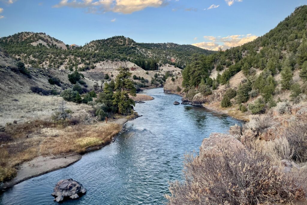
The Colorado River flows through Grand County, Colo. on Oct. 23, 2023. Negotiators from seven states remain at an impasse over how to share and conserve the river’s water despite four days of recent meetings together in Utah. (Alex Hager/KUNC)
It’s crunch time for negotiators from seven western states trying to strike a deal before Feb. 14 on how to share the dwindling Colorado River.
But four days of talks in a Salt Lake City conference room earlier this month did not appear to have sparked a breakthrough.
“We got tired of each other,” Utah’s negotiator, Gene Shawcroft, said Tuesday at a public board meeting, days after the meeting ended. “And two of the days, we made some progress, but one day we went backwards almost as much progress as we made in two and a half days.”
The states in the lower and upper basins remain at an impasse over how cuts to water use should be handled during times of drought.
A spokesperson for Colorado Gov. Jared Polis confirmed the meeting invitation Friday to KUNC and said in a statement that Polis “hopes to attend this meeting if it works for the other Governors.”
John Berggren, a water policy expert at Western Resource Advocates, said many of the scenarios on the table can only be taken if all the states in the basin agree to them.
“The fact that the states don’t have a seven state agreement right now means that we can’t consider some of these really good, new, innovative tools that are in some of the alternatives,” he said Tuesday. And so that’s that’s pretty frustrating.”
What could management of the vital waterway look like after the current rules expire in August?
Berggren, who got his Ph.D. at the University of Colorado focusing on sustainable water management in the Colorado River Basin, helped KUNC’s water desk summarize the five options on the table from the feds.
He said an eventual deal might incorporate pieces from several of the alternatives.
Basic coordination
This is the only path the feds say they currently have the legal power to take if the seven states fail to reach an agreement.
Berggren said this option would likely ‘normalize’ 1.48 million acre feet of water shortages each year in the lower basin states.
“And this would just basically say every year, that’s a given,” Berggren said.
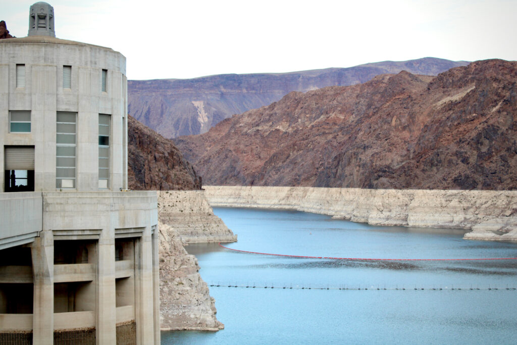
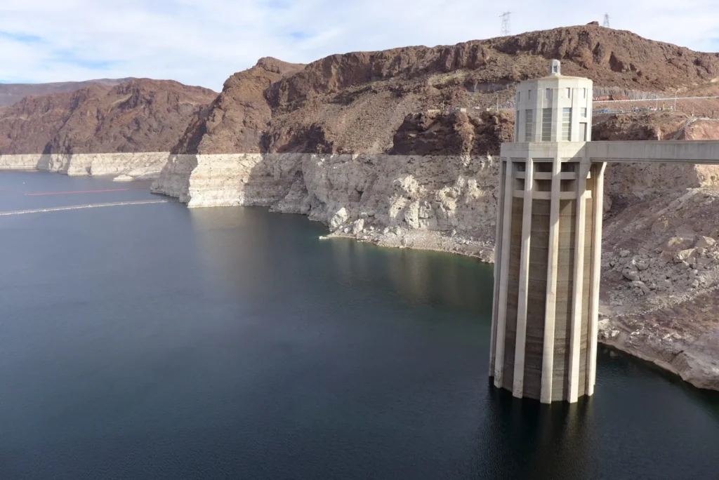
Water in Lake Mead sits low behind Hoover Dam on December 16, 2021. The nation’s largest reservoir, which has reached record-low levels in recent years, serves as the main source of water for the Las Vegas area. It is mostly filled with mountain snowmelt from Utah, Colorado, Wyoming and New Mexico. (Alex Hager/KUNC)
Water in Lake Mead sits low behind Hoover Dam on December 16, 2021. The nation’s largest reservoir, which has reached record-low levels in recent years, serves as the main source of water for the Las Vegas area. It is mostly filled with mountain snowmelt from Utah, Colorado, Wyoming and New Mexico.
A single acre foot is 326,000 gallons of water.
Upper basin states, including Colorado, would not be forced to contribute more water in dry years.
Berggren said this option “does not do enough.”
“There’s many years where the system crashes,” he said.
A crash means Lake Powell and Lake Mead reach deadpool, a scenario where they’re so critically low that hydroelectricity stops and water stops flowing through their dams.
Millions of water users in the west could see impacts.
Enhanced coordination
Berggren calls this plan ‘a little more innovative.’
Highlights include the power to use conservation pools that encourage and incentivize states and water users to find ways to save water.
That could mean the feds paying states to conserve water. Lower basin states could also put water they save in Lake Mead to stay there until they need it.
“It’s water security, because if we can save water today, we’ll put it into storage and we can withdraw it later when we need it,” Berggren said.
This option also includes contributions from the upper basin states each year that would gradually increase over time.
The Interior Department writes this option “seeks to protect critical infrastructure while benefitting key resources (such as environmental, hydropower, and recreation) through an approach to distributing storage between Lake Powell and Lake Mead that enhances the reservoirs’ abilities to support the Basin.”
No action
This plan might sound like the path with the least impact, but that’s far from the case.
This path would revert the operating procedures at Powell and Mead to what they were almost 20 years ago.
“It basically says Reclamation will shoot to release 8.23 million acre feet of water from Powell, and that’s kind of it,” Berggren said. “Not a lot of authority for lower basin shortages, not a lot of authority to modify your reservoir operations to try and prevent the worst from happening. No action very clearly crashes the system quickly, and no one wants it.”
As water levels in Lake Powell keep dropping, some say they could fall too low to pass through Glen Canyon Dam at sufficient levels. (Ted Wood/The Water Desk)
According to the Interior Department, “there would be no new mechanisms to proactively conserve and store water in Lake Powell or Lake Mead.”
This option was legally required to be included in the feds report on operating scenarios.
Maximum flexibility
This proposal was developed by a group of seven conservation groups.
Interior said this alternative is “designed to help stabilize system storage, incentive proactive water conservation, and extend the benefits of conservation and operational flexibility to a wide range of resources.”
It’s also designed to give dam operators more flexibility to respond to the impacts of climate change.
As water levels in Lake Powell keep dropping, some say they could fall too low to pass through Glen Canyon Dam at sufficient levels.
Berggren said this option allows water users to conserve water and store themit in reservoirs.
It would also change the way water releases are handled.
A “climate response indicator” would be introduced to help decide how much water should be released from Lake Powell.
“If the last three years have been really dry or exceptionally dry, then you adjust your Lake Powell releases,” he said.
Berggren and his environmental group, Western Resource Advocates, had a hand in developing this alternative along with the six other organizations.
All seven of the organizations that crafted the river management proposal have received funding from the Walton Family Foundation, which also supports KUNC’s Colorado River coverage.
Supply driven alternative
“All this does is say that what you release from Lake Powell down to Lake Mead is based on some percentage of the preceding three years,” Berggren said. “You look at the past three years, and you take some percentage of that, and that’s what you release from Glen Canyon Dam, and that’s basically it.”
He said the plan, which incorporates ideas from the states themselves, was nicknamed “the amicable divorce of the basins.”
“Because it was basically the upper basin will do its thing with Lake Powell and its upper basin reservoirs,” he said. “And then whatever gets released, lower basin deals with that, deals with Lake Mead, deals with lower basin shortages.”
Shortages in the lower basin could be up to 2.1 million acre feet a year in this scenario, according to the Interior Department.
This story is part of ongoing coverage of the Colorado River, produced by KUNC in Colorado and supported by the Walton Family Foundation. KUNC is solely responsible for its editorial coverage.
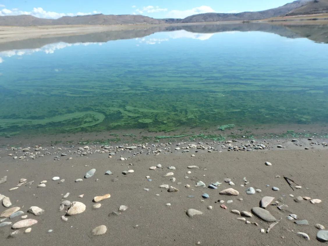
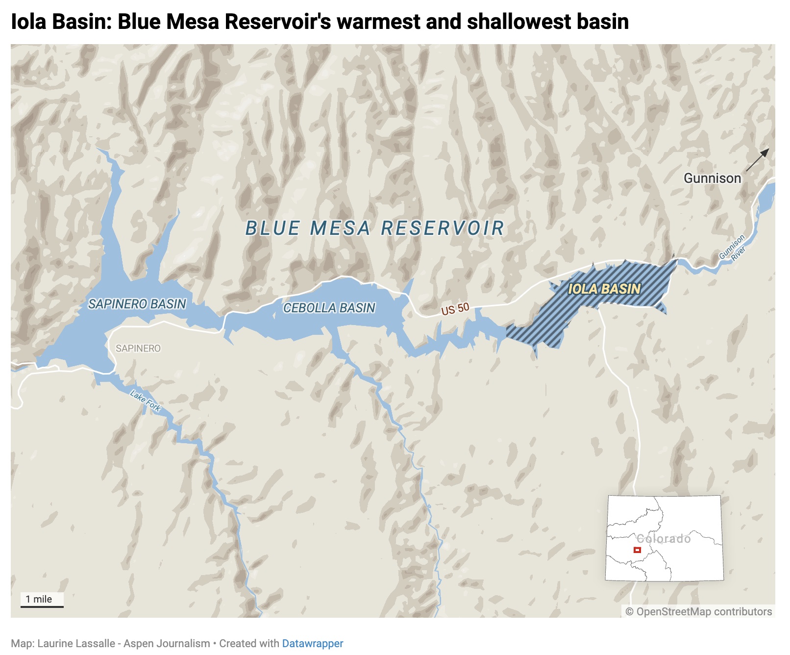
A toxic algal bloom in Iola Basin of Blue Mesa Reservoir in 2021. A new study says that keeping reservoir levels above a certain threshold could minimize the occurrence of these blooms. Credit: National Park Service
This story was originally published by Aspen Journalism on January 9, 2026.
A new study pinpoints the main cause of harmful algal blooms in Blue Mesa Reservoir, and includes a recommendation for a minimum water level to prevent them.
A study released in December by scientists at the U.S. Geological Survey and the National Park Service said the main driver for recent toxic harmful algal blooms in Blue Mesa is low reservoir levels, which create shallow and warm conditions favorable for algal growth. The study also says maintaining a water-level elevation above 7,470 feet might help minimize the occurrence of these blooms.
“When the reservoir gets below 7,470, which is 49 feet below full pool, every year that that happened during the growing season, the algae thrived and ended up producing toxins greater than health advisory,” said Katie Walton-Day, a research hydrologist with the USGS and a lead author on the study. “So the message is that that level is important, and I think more work needs to be done to understand the timing of that level.”
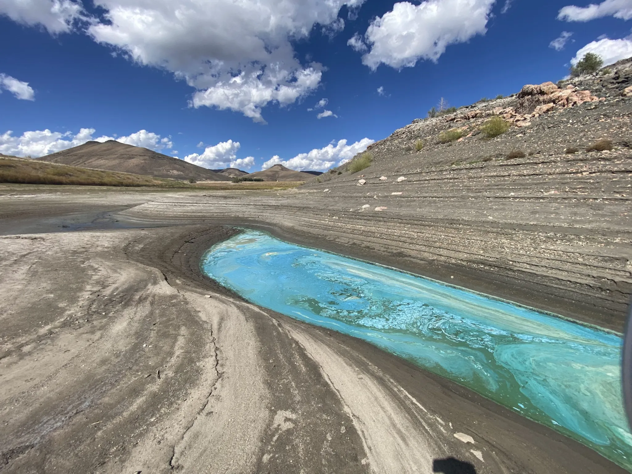
Blue-green algae that resembles pea soup or spilled paint on the water’s surface can form when nutrients are present and water temperatures are between 68 and 77 degrees Fahrenheit. These cyanobacteria blooms can be toxic to humans and animals, leading the park service to post warning signs to keep kids and pets out of the water in certain areas of Blue Mesa. These outbreaks can pose a threat to public health and negatively impact the local outdoor recreation economy.
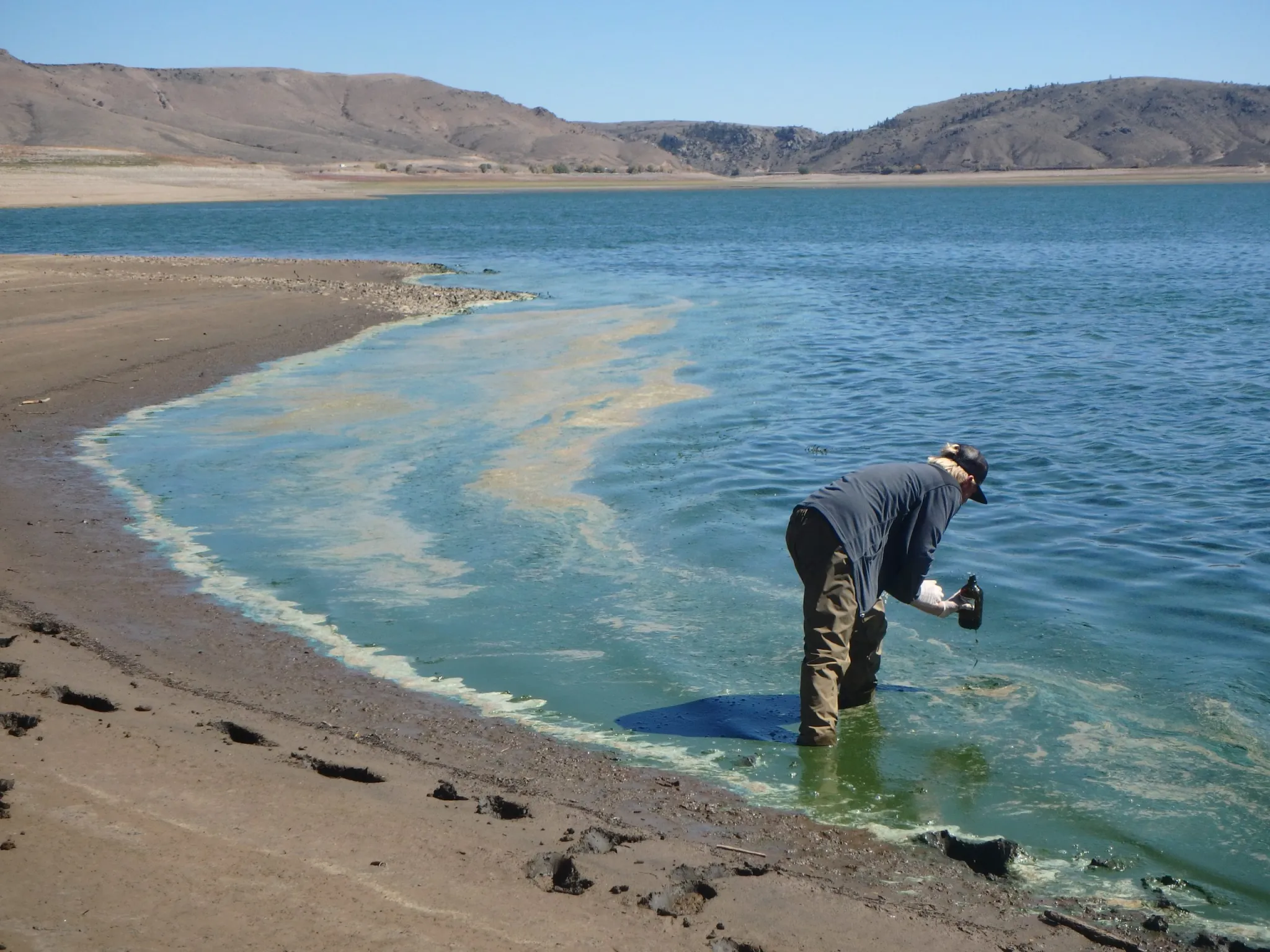
According to Walton-Day, beginning in 2018, toxic algae in the reservoir exceeded standards set by the Environmental Protection Agency and the Colorado Department of Public Health and Environment for recreational water quality and swimming, triggering the need for more research. Harmful algal blooms occurred again in 2021 and 2022. Scientists from USGS and the park service used remote sensing to detect the blooms and collected water quality data from 2021 to 2023 as part of the study.
Formed by damming the Gunnison River, Blue Mesa Reservoir is Colorado’s largest reservoir, with a capacity of about 940,000 acre-feet. Three separate basins make up the reservoir: Sapinero, Cebolla and Iola. Iola is the farthest upstream, the warmest and shallowest — and also the most likely to have toxic algal blooms.
“Iola develops these broad, shallow areas where things are warm and stagnant,” Walton-Day said. “We think that also contributes to the formation of algae.”
As near-daily afternoon winds kick up, they can stir up algae from the sediment on the bottom of the reservoir, further fueling the issue. The study also found no evidence that nutrients such as phosphorus and nitrogen were increasing, leaving low water levels as the likeliest main culprit of the blooms in recent years.
A cyan-colored algal mat area in a small inlet on the north shore of Iola Basin in Blue Mesa Reservoir in September 2022. Iola is the furthest upstream, shallowest and warmest of Blue Mesa’s three basins, and has the most toxic algal blooms. Credit: U.S. Geological Survey
More reservoir releases?
The Upper Gunnison Water Conservancy District helped fund the study by contributing $93,000 cash and in-kind donations, according to General Manager Sonja Chavez. Other sources of funding, in addition to the USGS and the park service, include the Colorado River Water Conservation District, Project 7 Water Authority, Gunnison County and Uncompahgre Valley Water Users Association.
In 2021, Blue Mesa’s marinas were forced to close early for the season because of low water levels caused by emergency releases from three reservoirs in the Upper Colorado River Basin: Blue Mesa, Navajo and Flaming Gorge. Water managers from Colorado, New Mexico, Utah and Wyoming were not happy with this unilateral action by the feds.
“They made those releases at a really horrible time here when water levels were low,” Chavez said. “You have to think about the economic impact to this community associated with those releases.”
But the study points to another reason for concern: The 36,000 acre-feet released from Blue Mesa contributed to a large reservoir dip, when water levels fell well below the crucial threshold for harmful algal blooms cited in the report of 7,470 feet.
“They promised us they won’t [take unilateral action] again, but there’s nothing that binds them to that verbal promise and now we have a new administration,” said John McClow, attorney for the conservancy district and an alternate representative to the Upper Colorado River Commission. “Reclamation is definitely looking at those Upper Initial Units as a resource to sustain Lake Powell.”
As water managers attempt to balance the need for water to boost Lake Powell, they now have another upstream impact to take into consideration. This year’s low snowpack and dismal projections mean there could be more releases from Blue Mesa in the future and, therefore, increased potential for more harmful algal blooms. In December, officials from the U.S. Bureau of Reclamation said releases from the three reservoirs — known as the Colorado River Storage Project Act reservoirs or the Upper Initial Units — are one of the tools the federal agency could use to prop up levels at Lake Powell to protect the ability to make hydropower at Glen Canyon Dam.
There’s a lot of uncertainty about how the Colorado River will be managed, reservoirs operated and shortages shared after 2026. Water managers from the seven states that share the river haven’t been able to find consensus about how to manage the river after the current guidelines expire at the end of the year.
And it’s unclear how much water the Bureau of Reclamation plans to release from each of the three upstream reservoirs or when. In a prepared statement, a spokesperson from the bureau said it is too early in the winter season to determine if additional upstream water releases will be needed and how much water those reservoirs will have available to release.
The bureau spokesperson said the agency does consider water quality and the prevention of toxic algal blooms when making decisions regarding reservoir releases, but that they must also “take into account the agency’s primary obligations, which include meeting downstream water deliveries for local irrigation districts with senior water rights to support agricultural needs, and fulfilling requirements related to endangered species protection.”
A National Park Service worker collects a toxin sample from an algal mat in Blue Mesa Reservoir in July 2021. A new study says low reservoir levels are the driving cause of harmful algal blooms in the reservoir. Credit: U.S. Geological Survey
Colorado River expert and author Eric Kuhn said that if reservoir releases happen in 2026, most of the water will come from Flaming Gorge.
“Unless things get really stormy in the next two months, we’re going to need a big DROA release,” Kuhn said, referring to the Drought Response Operations Agreement, which lays out actions each year to protect levels at Lake Powell. “Almost all of the water is going to come from Flaming Gorge. Simply, it’s a water-availability issue.”
With a capacity of nearly 3.8 million acre-feet, the reservoir that impounds the Green River on the Utah-Wyoming border stores much more water than either Blue Mesa or Navajo reservoirs.
Still, the prospect of more low water years in the future worries Chavez, whose specialty is limnology, or the study of freshwater lakes.
“Once you get these harmful algal blooms forming, all those algae die every year, they go back down to the bottom, and if you get the lake turnover, all that stuff gets remobilized throughout the system and you’re just causing a problem that’s self-feeding,” she said. “The more these reservoirs get tapped, the bigger this problem is going to become.”
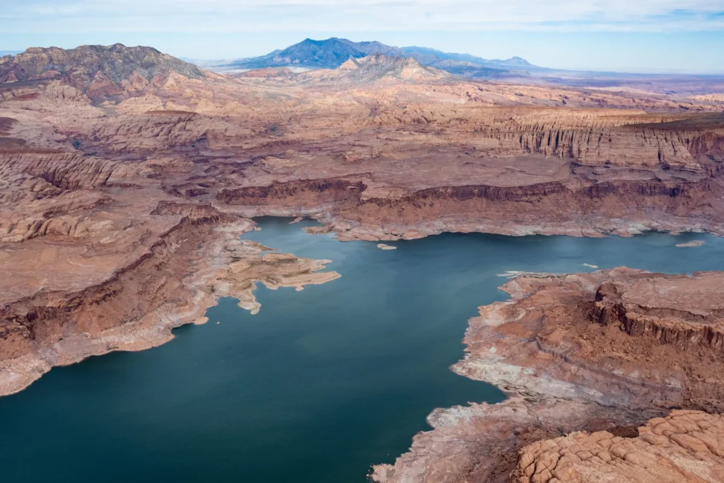
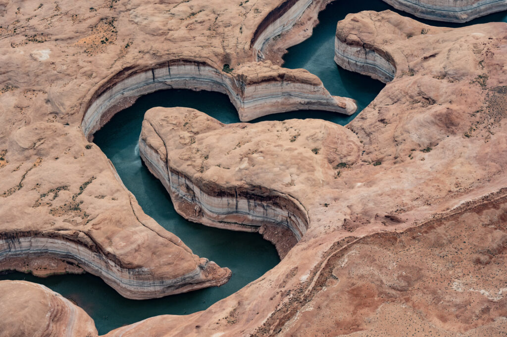
Lake Powell is seen from the air in October 2022. Three of the management options released by the feds have the option for an Upper Basin conservation pool in Lake Powell. Credit: Alexander Heilner/The Water Desk
This story was originally published by Aspen Journalism on January 15, 2026.
Federal officials have released detailed options for how the Colorado River could be managed in the future, pushing forward the planning process in the absence of a seven-state deal. But some Colorado River experts and water managers say cuts don’t go deep enough under some scenarios and flow estimates don’t accommodate future water scarcity driven by climate change.
On Jan. 9, the U.S. Bureau of Reclamation released a draft of its environmental impact statement, a document required by the National Environmental Policy Act, which lays out five alternatives for how to manage the river after the current guidelines expire at the end of the year. This move by the feds pushes the process forward even as the seven states that share the river continue negotiating how cuts would be shared and reservoirs operated in the future. If the states do make a deal, it would become the “preferred alternative” and plugged into the NEPA process.
“Given the importance of a consensus-based approach to operations for the stability of the system, Reclamation has not yet identified a preferred alternative,” Scott Cameron, the acting Reclamation commissioner, said in a press release. “However, Reclamation anticipates that when an agreement is reached, it will incorporate elements or variations of these five alternatives and will be fully analyzed in the final EIS, enabling the sustainable and effective management of the Colorado River.”
For more than two years, the Upper Basin (Colorado, New Mexico, Utah and Wyoming) and the Lower Basin (California, Arizona and Nevada) have been negotiating, with little progress, how to manage a dwindling resource in the face of an increasingly dry future. The 2007 guidelines that set annual Lake Powell and Lake Mead releases based on reservoir levels do not go far enough to prevent them from being drawn down during consecutive dry years, putting the water supply for 40 million people in the Southwest at risk.
The crisis has deepened in recent years, and in 2022, Lake Powell flirted with falling below a critical elevation to make hydropower. Recent projections from the U.S. Bureau of Reclamation show that it could be headed there again this year and in 2027.
John Berggren, regional policy manager with Western Resource Advocates, helped craft elements of one of the alternatives, Maximum Operational Flexibility, formerly called Cooperative Conservation.
“My initial takeaway is there’s a lot of good stuff in there,” Berggren said of the 1,600-page document, which includes 33 supporting and technical appendices. “Their goal was to have a wide range of alternatives to make sure they had EIS coverage for whatever decision they ended up with, and I think that there are a lot of innovative tools and policies and programs in some of them.”
The infamous bathtub ring could be seen near the Hoover Dam in December 2021. The U.S. Bureau of Reclamation has released a draft Environmental Impact Statement for post-2026 management of the river. Credit: Heather Sackett/Aspen Journalism
Alternatives
The first alternative is “no action,” meaning river operations would revert to pre-2007 guidance; officials have said this option must be included as a requirement of NEPA, but doesn’t meet the current needs.
The second alternative, Basic Coordination, can be implemented without an agreement from the states and represents what the feds can do under their existing authority. It would include Lower Basin cuts of up to 1.48 million acre-feet based on Lake Mead elevations; Lake Powell releases would be primarily 8.23 million acre-feet and could go as low as 7 million acre-feet. It would also include releases from upstream reservoirs Flaming Gorge, Blue Mesa and Navajo to feed Powell. But experts say this alternative does not go far enough to keep the system from crashing.
“It was pretty well known that the existing authorities that Reclamation has are probably not enough to protect the system,” Berggren said. “Especially given some of the hydrologies we expect to see, the Basic Coordination does not go far enough.”
The Enhanced Coordination Alternative would impose Lower Basin cuts of between 1.3 million and 3 million acre-feet that would be distributed pro-rata, based on each state’s existing water allocation. It would also include an Upper Basin conservation pool in Lake Powell that starts at up to 200,000 acre-feet a year and could increase up to 350,000 acre-feet after the first decade.
Under the Maximum Operational Flexibility Alternative, Lake Powell releases range from 5 million acre-feet to 11 million acre-feet, based on total system storage and recent hydrology, with Lower Basin cuts of up to 4 million acre-feet. It would also include an Upper Basin conservation pool of an average of 200,000 acre-feet a year.
These two alternatives perform the best at keeping Lake Powell above critical elevations in dry years, according to an analysis contained in the draft EIS.
“There are really only two of these scenarios that I think meet the definition of dealing with a very dry future: Enhanced Coordination and the Max Flexibility,” said Brad Udall, a senior water and climate research scientist at Colorado State University. “Those two kind of jump out at me as being different than the other ones in that they actually seem to have the least harmful outcomes, but the price for that are these really big shortages.”
The final scenario is the Supply Driven Alternative, which calls for maximum shortages of 2.1 million acre-feet and Lake Powell releases based on 65% of three-year natural flows at Lees Ferry. It also includes an Upper Basin conservation pool of up to 200,000 acre-feet a year. This option offers two different approaches to Lower Basin cuts: one based on priority where the oldest water rights get first use of the river, putting Arizona’s junior users on the chopping block, and one where cuts are distributed proportionally according to existing water allocations, meaning California could take the biggest hit.
This alternative is based on proposals submitted by each basin and discussions among the states and federal officials last spring. Udall said the cuts are not deep enough in this option.
“You can take the supply-driven one and change the max shortages from 2.1 million acre-feet up to 3 or 4 and it’s going to perform a lot like those other two,” he said. “I think what hinders it is just the fact that the shortages are not big enough to keep the basin in balance when push comes to shove.”
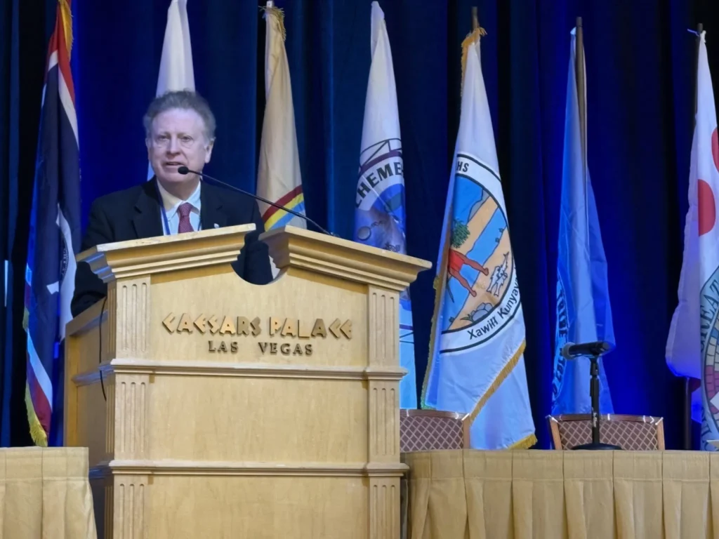
Reclamation’s Acting Commissioner Scott Cameron speaks at the Colorado River Water Users conference in Las Vegas in December 2025. The agency has released a draft Environmental Impact Statement, which outlines options for managing the river after this year. Credit: Heather Sackett/Aspen Journalism
Pivotal moment
In a prepared statement, Glenwood Springs-based Colorado River Water Conservation District officials expressed concern that the projected future river flows are too optimistic.
“We are concerned that the proposed alternatives do not accommodate the probable hydrological future identified by reliable climate science, which anticipates a river flowing at an average of 9-10 [million acre feet] a year,” the statement reads. “The Colorado River Basin has a history of ignoring likely hydrology, our policymakers should not carry this mistake forward in the next set of guidelines.”
The River District was also skeptical of the Upper Basin conservation pool in Lake Powell, which is included in three of the alternatives. Despite dabbling in experimental programs that pay farmers and ranchers to voluntarily cut back on their water use in recent years, conservation remains a contentious issue in the Upper Basin. Upper Basin water managers have said their states can’t conserve large volumes of water and that any program must be voluntary.
Over the course of 2023 and 2024, the System Conservation Pilot Program, which paid water users in the Upper Basin to cut back, saved about 101,000 acre-feet at a cost of $45 million.
The likeliest place to find water savings in Colorado is the 15-county Western Slope area represented by the River District. But if conservation programs are focused solely on this region, they could have negative impacts on rural agricultural communities, River District officials have said.
“Additionally, several alternatives include annual conservation contributions from the Upper Basin between [200,000 acre-feet] and [350,000 acre feet],” the River District’s statement reads. “We do not see how that is a realistic alternative given the natural availability of water in the Upper Basin, especially in dry years.”
In a prepared statement, Colorado officials said they were looking forward to reviewing the draft EIS.
“Colorado is committed to protecting our state’s significant rights and interests in the Colorado River and continues to work towards a consensus-based, supply-driven solution for the post-2026 operations of Lake Powell and Mead,” Colorado’s commissioner, Becky Mitchell, said in the statement.
The release of the draft EIS comes at a pivotal moment for the Colorado River Basin. The seven state representatives are under the gun to come up with a deal and have less than a month to present details of a plan by the feds’ Feb. 14 deadline. Federal officials have said they need a new plan in place by Oct. 1, the start of the next water year. This winter’s dismal snowpack and dire projections about spring runoff underscore the urgency for the states to come up with an agreement for a new management paradigm.
Over a string of recent dry years, periodic wet winters in 2019 and 2023 have bailed out the basin and offered a last-minute reprieve from the worst consequences of drought and climate change. But this year is different, Udall said.
“We’re now at the point where we’ve removed basically all resiliency from the system,” he said. “Between the EIS and this awful winter, some really tough decisions are going to be made. … Once we finally get to a consensus agreement, the river is going to look very, very different than it ever has.”
The draft EIS will be published in the Federal Register on Jan.16, initiating a 45-day comment period that will end March 2.
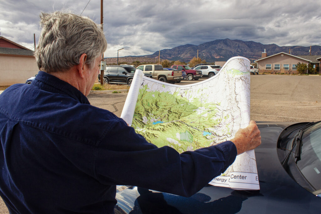
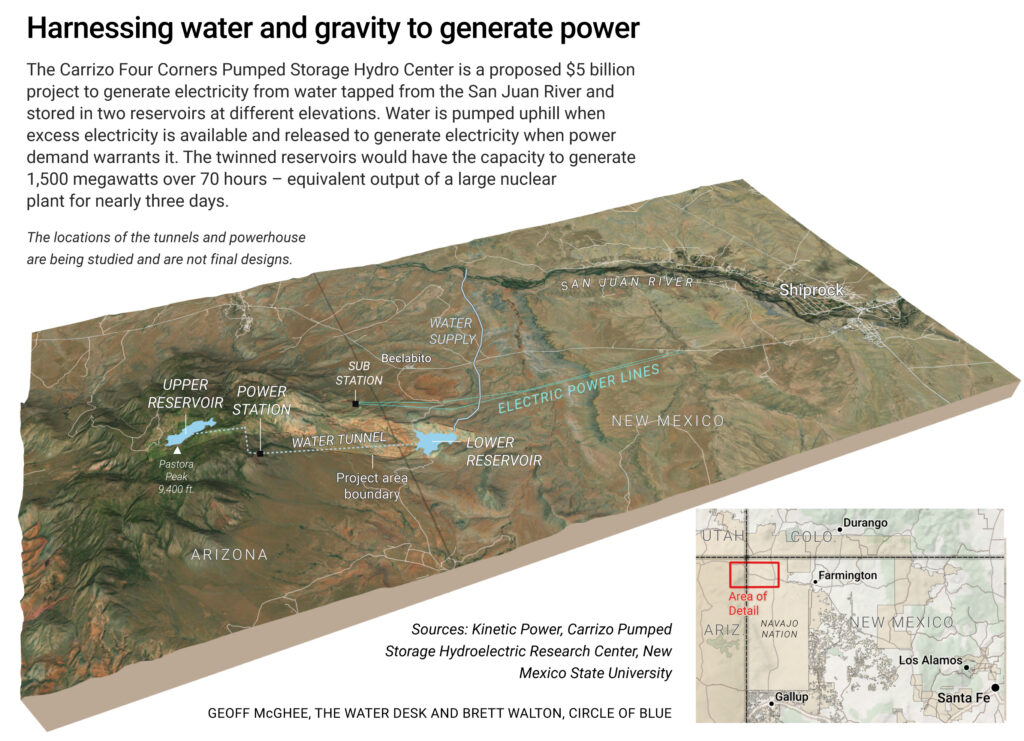
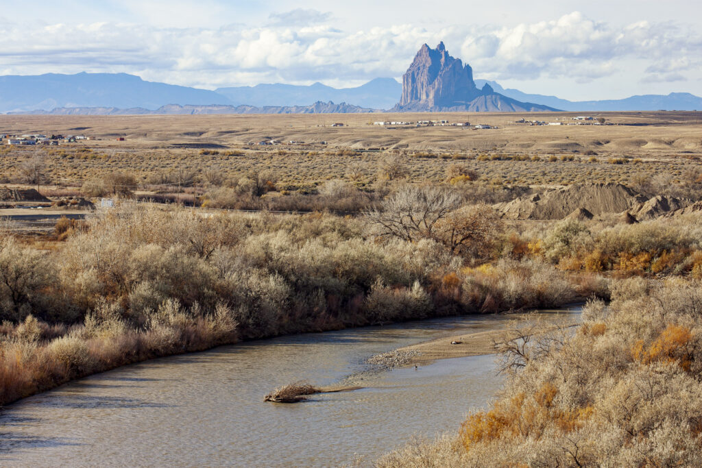
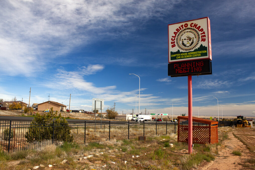
BECLABITO, N.M. – Standing in a breezy parking lot on Navajo land in the state’s far northwest corner, Tom Taylor looked toward the western horizon and then upwards at the furrowed mass of the Carrizo Mountains less than 10 miles away.
Water Desk Grantee Publication
This story was supported by the Water Desk’s grants program.
If all goes to plan, the infrastructure that could one day spill from the mountain’s flanks and through its core will become an essential piece of the region’s electric grid, able to store surplus electricity from renewable energy and other power sources for when it is needed later.
Fighting the wind that chilly November morning, Taylor used both hands to pin a detailed map against the hood of his Porsche Macan. A jumble of dashed lines and blue splotches representing proposed power lines, reservoirs, a water-supply pipeline, and access roads were printed atop the real-world geography on display in front of us.
“This will be a battery that lasts a long time,” Taylor said, holding tightly to the map.
The project is the $5 billion Carrizo Four Corners Pumped Storage Hydro Center, which is designed to be one of the largest long-duration energy storage projects in the country. Pumped storage moves water between two reservoirs at different elevations. Water is pumped uphill when excess electricity is available and released to generate electricity when power demand warrants it.
The $5 billion Carrizo Four Corners Pumped Storage Hydro Center is designed to be one of the largest long-duration energy storage projects in the country.
Taylor, a former mayor of Farmington and a state House representative from 2000 to 2014, is employed by Kinetic Power, the three-person, Santa Fe-based outfit behind the Carrizo proposal. The company sees the project as a way to make the region’s electric grid more durable and cost-effective, not only by smoothing the intermittent nature of wind and solar but also as a bulwark against energy emergencies like the winter storm in 2021 that caused blackouts and 246 deaths in Texas. The twinned reservoirs, using water sourced from a Colorado River tributary nearby, would have the capacity to generate 1,500 megawatts over 70 hours – a form of battery that could provide the equivalent output of a large nuclear plant for nearly three days.
“We believe that the key is delivering economic value,” said Thomas Conroy, Kinetic Power’s co-founder, who has four decades of experience developing energy projects.
What seems straightforward when placing lines on a map is much less so in three dimensions. Carrizo Four Corners, which is still in the exploratory stage and is at least five years away from breaking ground, has nearly as many questions as answers at this point. What is the geology within the Carrizo Mountains? Will it support a 3,300-foot-deep shaft, a subterranean powerhouse, and dam abutments? How will drought affect the water supply? What cultural sites and wildlife might be at risk from construction? What are the power market dynamics?
Answering those questions is the goal of a $7.1 million, two-and-a-half-year Department of Energy grant that Kinetic and its six university and research partners secured in August. (The state of New Mexico and the research partners are also contributing $7.1 million.) On the political side, will future Navajo administrations feel as favorably toward Carrizo as current president Buu Nygren?
The technical questions are but one piece of an ambitious project that touches many of the most pressing questions about natural resources in the American West today: energy development, water use, and the relationship between federal law and tribal law.
Connecting Water and Energy
Though the details are still to be worked out, the project can be described in broad strokes.
The Federal Energy Regulatory Commission, which oversees federal hydropower licensing, granted Kinetic a preliminary permit in 2021. In February 2025 FERC extended the permit, which allows for site investigations but no construction work, for another four years.
The company envisions two “off-channel” reservoirs that would not dam a flowing river. The lower reservoir will be near Beclabito. The upper, in the high reaches of the Carrizo Mountains. Both are on Navajo land, but on different sides of the Arizona-New Mexico border.
The powerhouse that holds the electricity-generating turbines will be located underground, some 3,300 feet below the upper reservoir. Some of the longest pumped storage tunnels in the country will be required to connect the reservoirs and the powerhouse.
Despite the geotechnical challenges, Conroy is particularly enthused by the site, which he said is the most optimal in Arizona and New Mexico – and possibly the entire country – to locate a pumped storage hydropower project.
The site stands out for four reasons, he said. It is near existing transmission corridors and grid connections due to the region’s legacy of enormous coal-fired power plants. And it will have a comparatively low capital cost for the energy it will produce.
The other two reasons relate to water. Because of the extreme height differential between the upper and lower reservoirs – almost three Empire State Buildings – less water will be required to produce a unit of energy than for reservoirs with a gentler gradient. And because the upper reservoir site is a deep canyon, surface area and thus evaporation will be minimized.
“Water is just top of mind here in the Southwest,” Conroy said. “And our project is as water-efficient as can be made.”
Water to fill the reservoirs would be drawn from the San Juan River, a tributary of the Colorado, via pipeline. The water would come from the Navajo Nation’s San Juan rights, which have been quantified but are not fully used.
How much water? In its FERC permit application, Kinetic estimated that the initial fill, which will take one and a half to two years, would require 38,300 acre-feet. To cover subsequent evaporation losses, the reservoirs would need to be topped up with 2,635 acre-feet per year. Those numbers will be refined in the feasibility studies.
“It’s what, about 1,300 acres of corn?” Taylor said, doing a rough mental calculation of the equivalent water consumption for the annual evaporation loss. “I think this is more valuable than 1,300 acres of corn.”
Saving for Tomorrow
So far the project has threaded the federal government’s fraught energy politics. The Trump administration is hostile to wind and solar, which in their eyes reek of liberal values. Two water-based technologies – hydropower and geothermal – have escaped condemnation and are listed in the administration’s energy dominance documents. The DOE grant that Carrizo secured is a holdover from the Biden administration’s infrastructure bill, which provided up to $10 million for feasibility studies for pumped storage projects that would store renewable energy generated on tribal lands.
Storage is the holy grail of renewable energy.
Storage is the holy grail of renewable energy. Human civilization has advanced, from the dawn of agriculture to the artificial intelligence revolution today, by being able to carry a surplus from one season and one year to the next. So it is with wind and solar. To maximize their utility and counteract their intermittent nature, engineers have been searching for cost-effective ways to store energy when the sun shines and when the wind blows for the days when neither of those things happen.
“If you want to improve the resiliency of the system, you either build more firm capacity instead of more renewable, or you build longer storage,” said Fengyu Wang, a New Mexico State University assistant professor who is the principal investigator for the DOE grant.
Storage has taken many forms. Some are fantastic mechanical configurations – lifting heavy objects and dropping them, or forcing air into caverns and releasing it. Thermal options use molten salt to trap the sun’s heat. The most familiar are batteries, which leverage chemical energy. But the most common, at least in the U.S., is pumped storage hydropower.
The 43 pumped storage facilities in the U.S. represent the bulk of the country’s utility-scale energy storage. They accounted for 88 percent of the total in 2024, according to Oak Ridge National Laboratory. That is changing quickly, however, as more battery storage comes online. The share for pumped storage was 96 percent in 2022.
Still, long-duration storage is where pumped storage shines. According to Oak Ridge, the median battery storage is two hours. For pumped storage, it is 12 hours. Longer duration provides more buffer, not only from day to day but also season to season.
In that regard, Carrizo would signify a huge leap. The only comparable pumped storage project under consideration in the U.S. is Cat Creek, in Idaho. Even though its duration is 121 hours, its generating capacity is less than half, at 720 megawatts.
Carrizo will have a different use case than other U.S. pumped storage projects, Conroy said. Many facilities have one customer and one generator. A nuclear plant, for instance, might be paired with a pumped storage system so that the nuclear plant can run continuously.
For Carrizo, there might be a consortium of utilities that have multiple generating sources feeding into this project and moving the water uphill. They would take delivery of that power across a large region with different climatic conditions and different needs for when and how they use the stored power. That means operating the facility will be more complicated than a traditional pumped storage project. One thing is certain, Conroy said: the Navajo will have an equity stake.
Tribal Outlook
Caution on the part of the Navajo would be understandable. The tribe’s lands have long been the center of energy developments with environmentally ruinous but economically helpful outcomes.
Uranium mining to fuel the Manhattan Project and then the nation’s reactors polluted rivers and groundwater, as did the coal mines that fed Four Corners Power Plant and the now-shuttered Navajo Generating Station and San Juan Generating Station. On the other hand, these developments provided employment and income. Navajo Mine, which supplies Four Corners Power Plant, accounts for about 35 percent of the Navajo Nation’s general fund.
Navajo and other tribal lands in the Four Corners region have been the target for a handful of pumped storage proposals in recent years. The Navajo Nation opposed three projects proposed for the Little Colorado River watershed, which were either withdrawn by the developer or denied a permit by FERC. Two other projects – Carrizo and Sweetwater, both using San Juan River water – are still in development. Sweetwater, a smaller project with eight hours duration, is co-developed by the Ute Mountain Ute Tribe and Gridflex Energy. A third project, Western Navajo Pumped Storage, which would be located near the former Navajo Generating Station, received a FERC preliminary permit in August.
Carrizo has not run into the same level of opposition as the other proposals. In part that is due to the proposed use of the San Juan River instead of groundwater, said Erika Pirotte, an assistant attorney general in the Navajo Nation’s water rights unit. Many Navajo communities rely on groundwater, and using it for pumped storage was viewed as unreasonable.
The lack of strong opposition is also because of Kinetic’s engagement with the Navajo Nation. The company has held meetings with the Beclabito, Red Valley, and Teec Nos Pos chapters, in addition to meetings with Navajo Nation agencies and Buu Nygren, the Navajo Nation president. Kinetic has a memorandum of understanding with Nygren, who also signed a letter of support for the project’s DOE grant application.
“We have the support of the council,” Conroy said. “We have a very high level of support from the president, and he is just extraordinarily interested in this project and seeing that it moves forward.”
From the Navajo perspective, what is interesting are the “ancillary benefits” that could come from the water supply pipeline, Pirotte said. Once the reservoirs are filled and the pipeline’s full capacity is not needed, the extra space could be repurposed for tribal water supply uses.
“That’s why the feasibility studies are really important for the Nation, because they help us understand to what extent Navajo Nation resources would be used for the project,” Pirotte said.
None of this is immediately around the corner, Conroy cautions. The DOE grant extends for more than two years. The FERC permitting process could be another two to four years. With Congress and the Trump administration talking about faster permitting and better coordination, that timeline is a best guess.
And then there is the question of tribal authority in the permitting process, not just for the Carrizo project but for other such developments. Will FERC abide by its 2024 stance that preliminary permits for hydropower projects on tribal lands require tribal consent? The Trump administration would like to see that policy scrapped. If FERC approves a project must a tribe assent to all the associated infrastructure? Will the Navajo be allowed to conduct reviews and issue permits?
And then there is construction, the biggest component. That will take four to six years, Conroy said.
Even on an ambitious timeline, Carrizo is not operating until the mid-2030s.
“I’m 77,” Taylor said. “I probably won’t see it.”
This story was produced by Circle of Blue, in partnership with The Water Desk at the University of Colorado Boulder’s Center for Environmental Journalism.
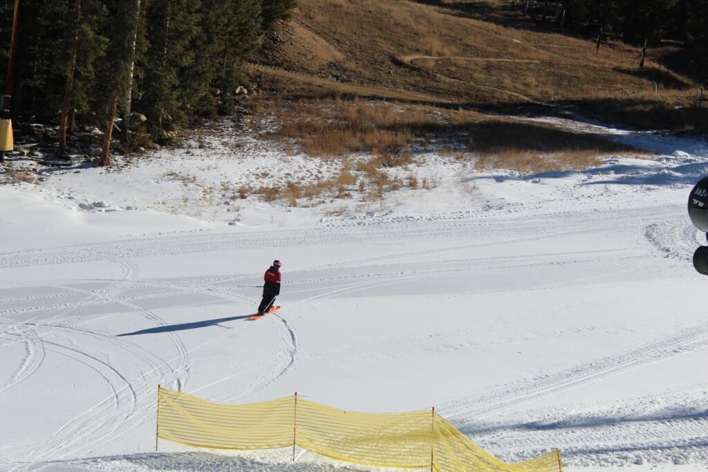
Schoolmarm, a beginner-friendly run at Keystone, offers views of Dillon Reservoir all the way down to the base of the mountain. Snowmaking guns line the run’s entire length, and use water from the reservoir for operations. (Caroline Llanes/Rocky Mountain Community Radio)
As guests ski and ride down Schoomarm, a stretch of beginner-friendly terrain at Keystone Resort in Colorado, they are treated to views of Dillon Reservoir nearly the whole way down. More eagle-eyed skiers and riders will notice that snowmaking machines line the run’s three miles, which spans from summit to base.
On a sunny, cloudless November day, it’s one of the resort’s only accessible ski runs with much of the credit going to those machines.
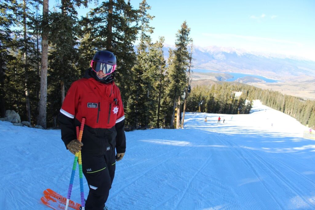
“It gives pretty much everybody the ability to ski here on day one,” said Kate Schifani, the resort’s senior director of mountain operations. She says Keystone is super focused on that early opening day.
“We are the first resort in the country to open,” she said, referring to the 2025 season. “So we put a lot of stock in what we can do early-season, and having great snowmaking helps us do that.”
It’s a familiar problem for Rocky Mountain ski resorts over the last 20 years, which have become increasingly prone to scant early season snow. Many have chosen to stick with their traditional opening days near the Thanksgiving holiday and take the gamble that snow might arrive in time. To match their guests’ demands for skiable acreage amid a warming climate, resorts are doubling down on snowmaking technology and acquiring the water rights needed to make it happen.
Winter is off to a slow start across the West this year. Snowpack is below average in every major river basin across the entire region. That’s a concern for ski resorts, many of which have delayed their opening days. That includes Jackson Hole in Wyoming, Alta in Utah, and Beaver Creek, just down the highway from Keystone.
Keystone’s Kate Schifani skis over to one of the resort’s pumphouses, which transports water to its snowmaking machines. The slow start to winter meant that in November, large patches of mountain still had no snow cover. (Caroline Llanes/Rocky Mountain Community Radio)
Human-caused climate change has changed the way precipitation falls in the mountains, especially in autumn. As more early season storm clouds bring rain instead of snow, resorts are increasingly relying on snowmaking to give their guests the ability to ski at all.
But this year, it wasn’t just a lack of snow that caused resorts headaches. November was warm as well, which also affects snowmaking operations. Throughout the Upper Colorado River Basin, temperatures were anywhere from five to eight degrees above average, with much of Utah setting records. Denver logged its warmest November day ever this year.
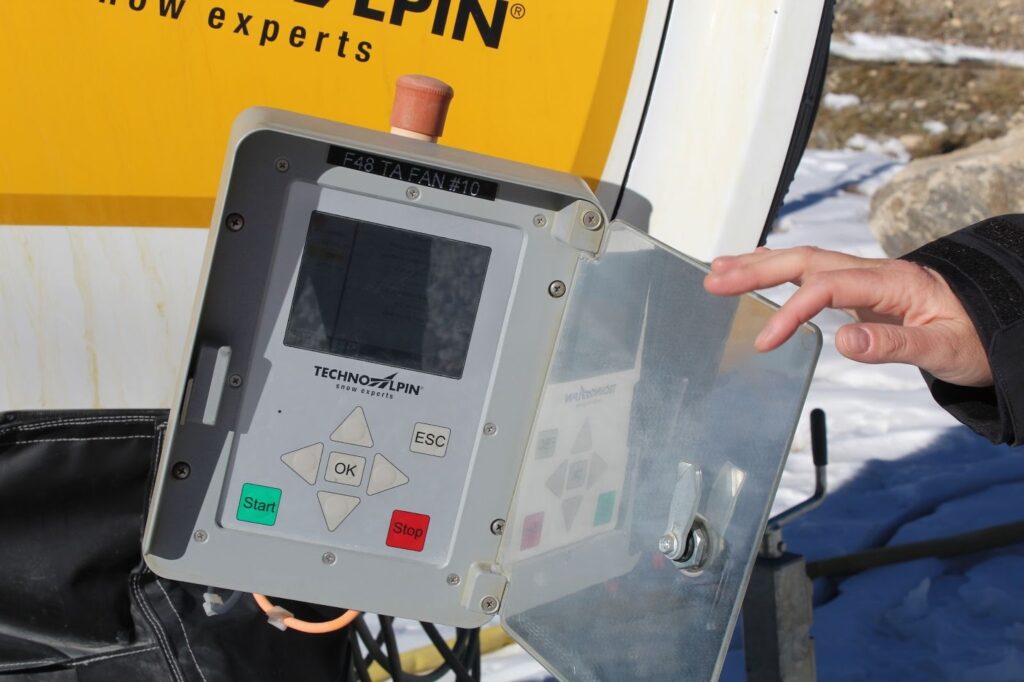
Schifani said ideally, snowmaking happens when it’s colder than 28 degrees.
“So it’s 32.7 degrees right now,” she said, checking the temperature on a monitor attached to one of the snow guns at the top of the River Run gondola. “So we’re just a little too warm for snowmaking.”
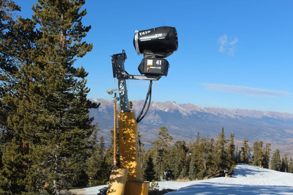
Keystone made upgrades to its snowmaking system in 2019, so all of its guns are relatively new. Each one has a weather system built into it, detecting temperature and relative humidity. They’re all automated, so when it finally drops below 28 degrees, the guns turn on with a loud rumble.
Schifani shows where the weather systems on Keystone’s snow guns are located. These systems allow the gun to sense when it’s cold enough to make snow, and they turn on automatically. (Caroline Llanes/Rocky Mountain Community Radio)
“This gun will know as it gets colder, we can add more water, we can make more snow,” Schifani explained. “As it gets warmer, we cut back on the water, we make a little bit less snow until it gets too warm for us to make snow at all.”
Once it’s cold enough, man-made snow takes about two parts compressed air and one part water. Unlike other uses in the West that transport water over long distances to sprawling cities or faraway farm fields, snowmaking keeps water close to where it originated.
Steven Fassnacht, a professor of snow hydrology at Colorado State University, said that about 80% of the water used in snowmaking goes back into the watershed it came from.
Snow guns line Keystone’s three-mile beginner run, Schoolmarm, for a consistent skiing experience from top to bottom. (Caroline Llanes/Rocky Mountain Community Radio)
“(Ski resorts) are taking water out of the river, out of a reservoir… and they’re putting it on the mountain and they’re storing it somewhere different for the winter,” he said. “So the actual use, we call it consumptive use, the amount of water that leaves the system is relatively small.”
But that use still matters in a region where every drop of water is accounted for. Fassnacht said it will matter even more as the region’s climate gets warmer and drier, and as competition for water ramps up.
“In drier conditions, maybe that water use—possibly, likely—that consumptive use is actually going to increase,” he said. “And it may be harder to actually get that water out of the system to put on the mountains.”
Ski areas’ water usage can get contentious. Telluride Resort is currently in a dispute with the town of Mountain Village over its water use, and a federal court recently dismissed a lawsuit from Purgatory, a resort near Durango, over accessing decades-old groundwater rights on Forest Service land.
Chris Cushing is a principal with the consulting firm SE Group, which works on mountain planning for resorts across the country.
He recently worked with Deer Valley in Utah on a massive expansion: the resort added ten new chairlifts and doubled its skiable terrain, which it plans to open this season — with a state of the art snowmaking system.
“It’s just massive, it’s literally building a new ski resort,” he said of the expansion, which is called East Village.
Cushing says the expansion was only possible because the land acquired by Deer Valley already had water rights allocated to it — a calculation many other resorts he works with are having to factor in their plans as well.
“Absolutely the first question I ask is, ‘what’s your water situation?’” he said.
Long-term drought means ski resorts aren’t just in the game of acquiring new supplies, but also how to make the water they do have go further.
Kate Schifani, Keystone’s senior mountain operations director, oversees the resort’s snowmaking. She says Schoolmarm is prioritized for snowmaking, so guests of all skill levels can get in on the early season action. (Caroline Llanes/Rocky Mountain Community Radio)
In 2023, Keystone added a new chairlift, providing skiers and riders easier access to its Bergman Bowl, which used to be an area only hikers could reach. Schifani says the resort expanded its snowmaking system to blanket that area at will too.
“But for perspective, that didn’t take any more water than we had previously used because we just got better at using what we already have,” she said.
It’s not yet clear what this winter will bring for the ski industry, but resorts, like other water users across the West, will have to prepare for the reality of doing more with less.
This story was produced in partnership with The Water Desk at the University of Colorado Boulder Center for Environmental Journalism.
Copyright 2025 Rocky Mountain Community Radio. This story was shared via Rocky Mountain Community Radio, a network of public media stations in Colorado, Wyoming, Utah, and New Mexico, including Aspen Public Radio.
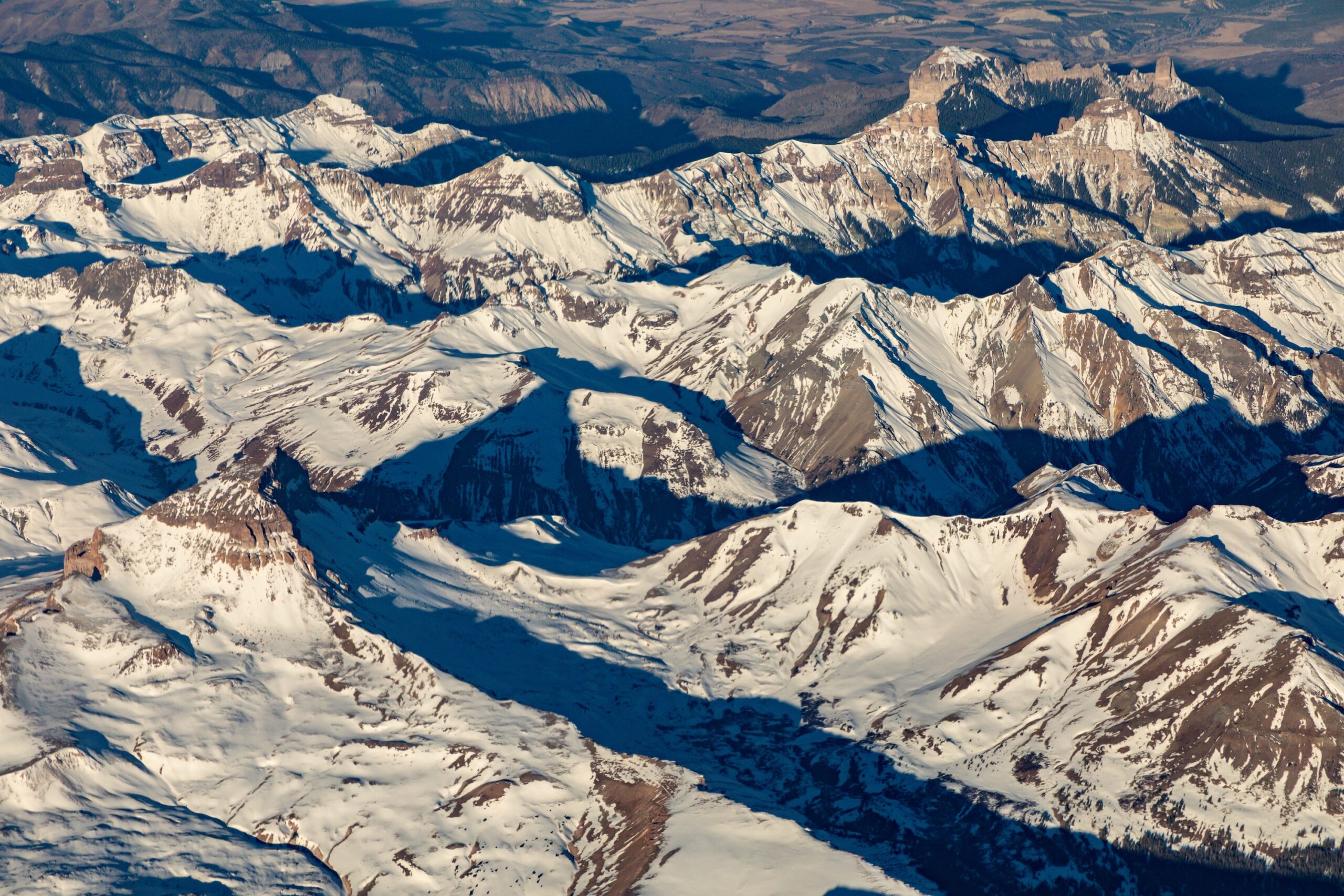
Aerial view of the snowpack in the San Juan Mountains of southwest Colorado on Dec. 3, 2021. Scientists and water managers use a variety of methods to monitor the snowpack, which supplies most of the water flowing in many Western streams and rivers. Photo by Mitch Tobin/The Water Desk.
A controversial recent study highlights an old truth about the American West’s snowpack: it’s difficult to measure—and just as hard to forecast how much of its water will ultimately reach tens of millions of people and vast swaths of farmland.
Water managers have increasingly turned to aircraft that use lasers to gauge the snowpack across entire basins. But the Aug. 15 scientific paper argues for a less expensive strategy: focusing new monitoring efforts on a select number of locations known as “hotspots” that excel at predicting how much water will run off from the snowpack—a frozen reservoir that can change dramatically over short distances.
Snowfall rates vary widely with elevation, and the amount of water locked in falling snowflakes shifts from storm to storm.
On the ground, snow accumulation depends on the wind, the forest canopy overhead, the exposure to the sun and the amount of dust that lands on the snowpack. Even a homeowner armed with a ruler can find very different snow depths depending on where they poke in their backyard.
For water providers, knowing how much water is stored in the snowpack is essential. In much of the West, snowmelt supplies most of the runoff that flows through streams, rivers, reservoirs, irrigation canals and household faucets.
If water managers overestimate the snowpack, their customers can be left high and dry later in the year. But if analysts underestimate streamflows, reservoirs can fill faster than expected—raising the risk of disastrous flooding.
With climate change making the snowpack less reliable and redefining what “normal” means, the pressure on forecasters is intensifying in a rapidly growing region with a well-documented gap between water supply and demand. Even a perfect knowledge of the snowpack’s water content doesn’t guarantee accurate streamflow projections because factors such as soil moisture, groundwater levels and late-season weather cloud the picture.
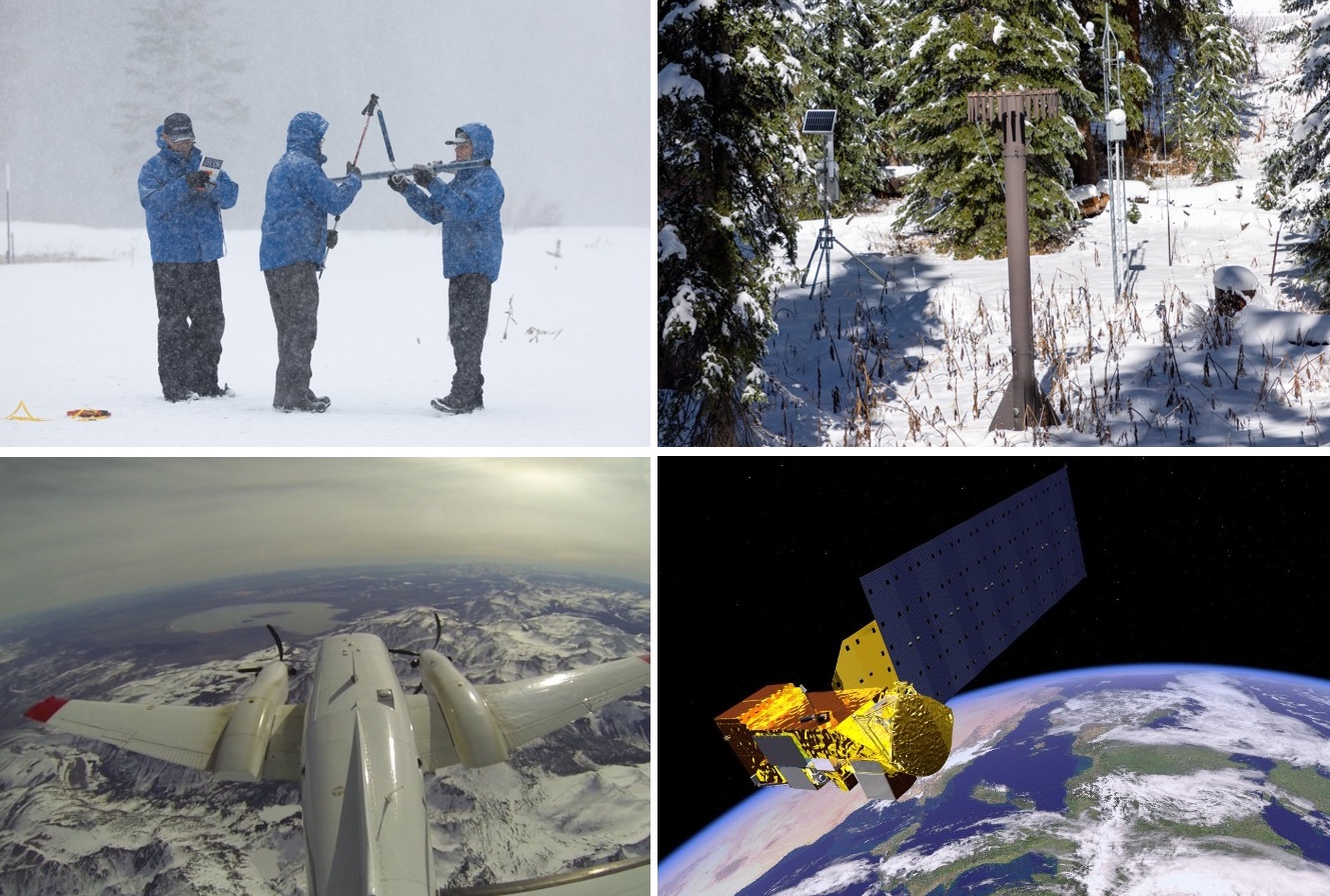
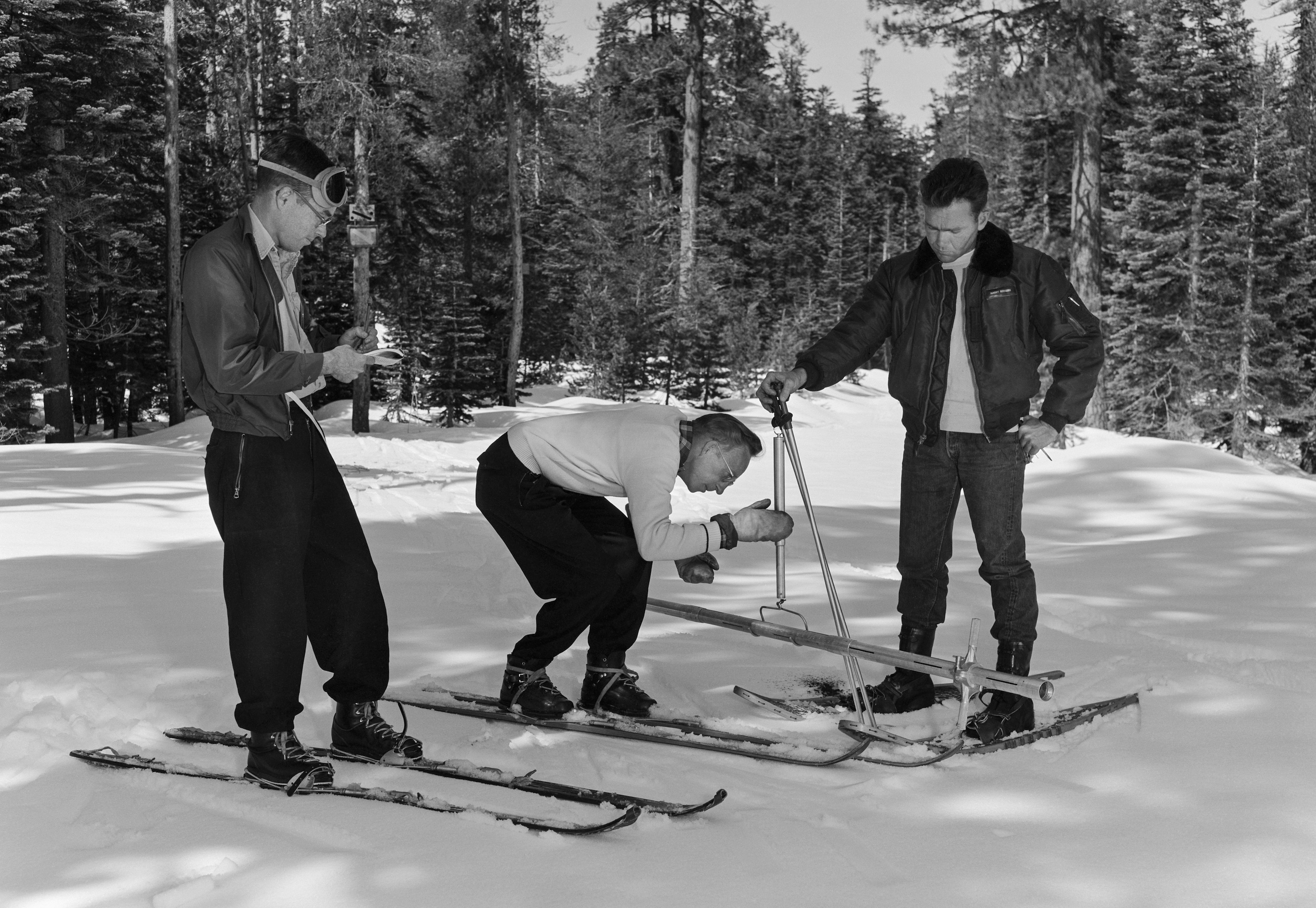
Scientists and water managers, aware of the high stakes, began formally measuring the snowpack to make water forecasts more than a century ago. They selected key locations in the high country, plunged hollow metal tubes into the snow and weighed the extracted cores to calculate the water content—a technique still used extensively today.
During the late 20th century, officials installed hundreds of automated stations across the West’s watersheds as part of the SNOTEL network. These sites use “snow pillows” to measure the weight of the overlying snow and estimate its water content. Forecasters then correlate these long-term snow records with historical streamflows to predict a basin’s water supply.
In the 21st century, airborne snow surveys have expanded rapidly. Aircraft equipped with lidar—a laser-based technology—precisely map the snow depth across entire watersheds while an onboard spectrometer scans the snowpack’s reflectivity. Snow depth is determined by subtracting lidar readings taken when snow is absent from those taken when snow is present. Scientists combine those measurements with estimates and observations of snow density to calculate the water content, known as the snow water equivalent.
Satellites also provide valuable data on the snowpack, especially its extent on the ground, but reliably measuring snow water equivalent from space remains elusive. Clouds and forests can also obscure or complicate a satellite’s view.
Four ways scientists monitor the snowpack. Clockwise from upper left: a manual snow-course survey (California Department of Water Resources); an automated SNOTEL station (Mitch Tobin/The Water Desk); an illustration of a satellite carrying the MODIS instrument (NASA); and airborne mapping (NASA).
While technologies that estimate an entire watershed’s snowpack are on the rise, the recent hotspots study argues that water forecasters could gain crucial insights by targeting future monitoring at a limited set of locations.
The authors say these 62-acre hotspots not only are strong predictors of how much water will run off in the spring and summer, but also could be more cost-effective than mapping the snowpack across a whole watershed using aircraft. That approach has become more common due to the work of Airborne Snow Observatories, Inc. (ASO), a company that spun out of research at NASA’s Jet Propulsion Laboratory.
“The greatest gains in water supply prediction come from leveraging existing stations and expanding snow measurements to the right places, rather than everywhere,” the authors write in Communications Earth & Environment.
But in the tight-knit world of Western snow science, the paper has sparked pushback from supporters of airborne snow monitoring.
Jeff Deems, a co-founder of ASO, said the paper is a “statistical curiosity” and criticized both its methodology and the conclusions it draws about snowpack monitoring.
“Our datasets have become the gold standard, the benchmark against which others are evaluated,” Deems said.
The Colorado Airborne Snow Measurement (CASM) program produced a strongly worded critique of the study, which used a proxy for the ASO data, rather than actual measurements from aircraft.
“Although this paper is published in a well-known journal, it makes unsupported, misleading and editorialized claims about the cost, value, and performance of airborne lidar for streamflow forecasting,” said the rebuttal from CASM, a group of stakeholders whose planning team includes ASO, water providers, the Colorado Water Conservation Board (CWCB) and other organizations. “The authors make a series of critical logic and analysis errors which when combined with their over-broad conclusions result in a very misleading paper.”
But study co-author Cam Wobus wrote in an email that the paper “might have struck a nerve” because “it showed that wall to wall measurement of snow may not be needed to create more accurate water supply forecasts, which ASO could have perceived as a threat to their business model.”
Despite the sharp differences among snow researchers, experts agree there’s no silver bullet for monitoring the snowpack or predicting streamflows. As warming temperatures and evolving storm patterns continue to transform the snowpack, both old-school methods and newer technologies will be needed to better manage the region’s scarce water resources.
“Snowpack estimation and streamflow forecasting is a vast and unsolved field of research,” the CWCB wrote in response to questions from The Water Desk.
Although CWCB’s logo was included at the bottom of CASM’s rebuttal, the agency said in an email that the document “should not be misconstrued as an official position statement” and that “CWCB has acted as a funding and coordination partner” to CASM.
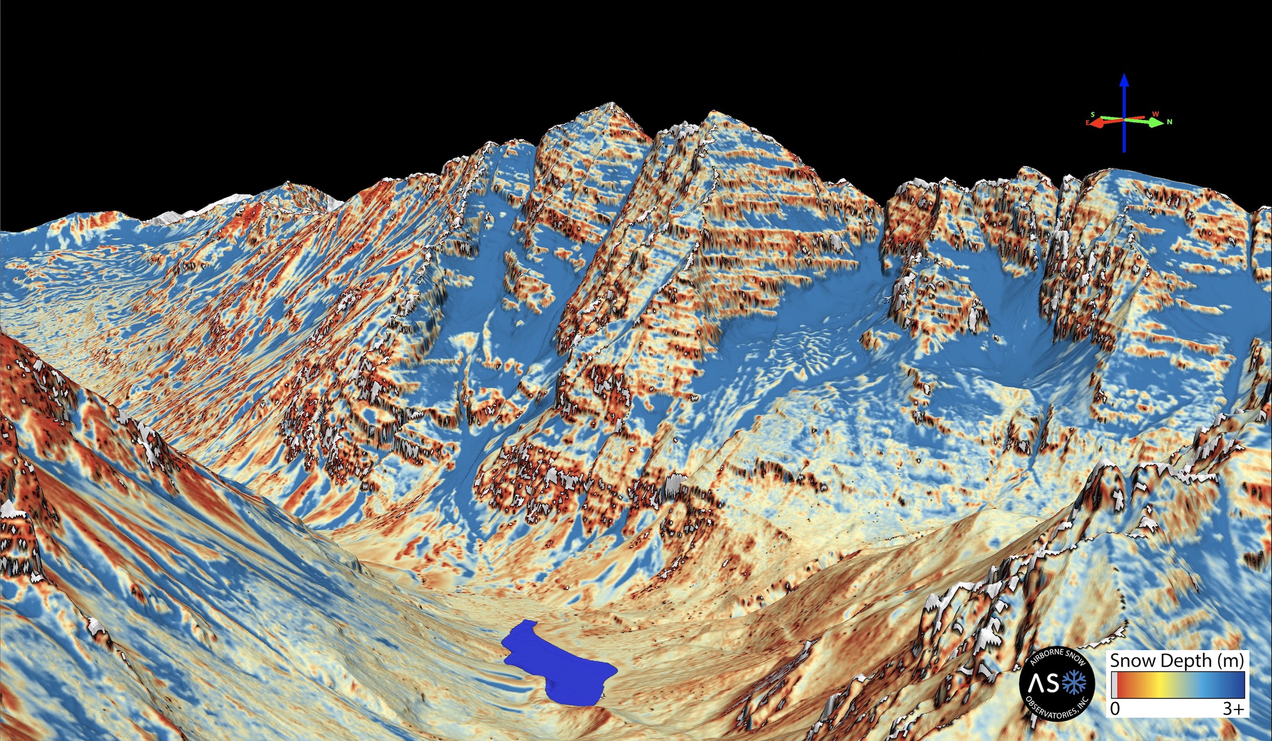
An airborne survey created this map of snow depth for Colorado’s Maroon Bells on April 9, 2024. Source: ASO.
Searching for snowpack hotspots
The hotspots study set out to test an intuitive idea: in high-elevation watersheds, the snowpack in certain locations can be especially useful for predicting streamflow.
“There are places within drainage basins that, if you train your water-supply forecast on the snow record in those locations, you’ll have a better forecast than if you use the basin average,” said co-author Eric Small, a professor of geological sciences at the University of Colorado Boulder.
“If you think about a drainage basin, there’s going to be places in that drainage basin where there’s not a lot of snow, or there’s not much connection between the snowmelt and the runoff,” Small said. “There’s going to be other places in the basin where there is a lot of snow and a lot of connectivity between the snowmelt and the runoff. So it should not be a surprise that there’s locations within a basin that are more predictive of this seasonal water supply.”
In general, locations with the deepest, most persistent snow are more likely to be hotspots.
“Anyone who’s seen a basin in Colorado and sees the south-facing slopes that are bare of snow and the north-facing slopes that have snow three feet deep in the springtime recognizes that once you take an average across all of that, the stuff on the south-facing slopes isn’t going to matter at all,” said Wobus, a principal at CK Blueshift, LLC, a consulting firm that works on water and climate issues.
“It’s silly to fly an entire basin if 30% of that basin doesn’t have any snow on it, so that’s an easy fix right there,” Wobus said.
While hotspots typically accumulate lots of snow, what’s happening beneath the snowpack is just as important. “The hotspots are locations where there’s both a lot of water, and when it melts, a large fraction of that water would get into the stream,” Small said.
Hotspots tend to have shallow or relatively stable groundwater storage and soil moisture levels that don’t vary year to year.
“The hotspots are places where there’s either enough snow or minimal enough variations in storage that the water is getting to the stream and the water is getting to the stream at the right timescale,” Small said.
Each basin may have numerous hotspots. “The hotspots weren’t unicorns,” Small said. “There were many possible hotspots. We had an objective measure to choose the official hotspot in the paper, but you could have chosen many other locations that were also predictive.”
Once a hotspot is identified, the authors outline several potential ways to tap its predictive power. One option is to add a new SNOTEL station at the site, although that may not be feasible because of the terrain or land protections. Another possibility is to use remote sensing from a plane or a drone. The authors write that one or two flight paths that observe the hotspot could gather data “at a substantially lower cost than more conventional wall-to-wall basin coverage.”
Even recreationists could help gather data from snowpack hotspots. “You could use citizen science to do it. You could send a bunch of backcountry skiers out to your location for fun, give them an app,” Small said. “They’re probably already going there. If you saw where people were skiing, they would probably have mapped out the hotspots already.”
A shortcut, or a statistical trap?
Critics of the hotspots paper agree that some parts of a watershed can carry more predictive weight for streamflows than others.
“It’s not a new concept, and it’s a very seductive one. It’s essentially the premise behind the SNOTEL network,” Deems said.
But to some scientists who dispute the study, hotspots can hide as much as they reveal—and potentially mislead water managers as the West’s climate evolves and as the hydrology of high-country landscapes is reshaped by disturbances, such as the increasing frequency of wildfires.
“Even if they did everything right—found these hotspots—the likelihood of them retaining the same statistical predictive power going forward is essentially nil,” Deems said.
The rebuttals to the paper have challenged both its analysis and the real-world implications the authors infer from their results.
Noah Molotch, a professor of geography at the University of Colorado Boulder and director of the Mountain Hydrology Group at the Institute of Arctic and Alpine Research, said “the study doesn’t accurately portray the direction that water managers have been moving for a couple of decades now.”
“My concern there is that it takes us further down the path of being blind to the spatial patterns that govern water supply and that can lead to surprises for water managers,” Molotch said.
Although the hotspots study has implications for airborne snowpack monitoring, the paper didn’t analyze data gathered by aircraft, which has been collected only in select watersheds and over a shorter time period than the authors examined.
Instead, one of the ways the researchers probed the snowpack in 390 basins in the West was to combine satellite data from 2001 to 2023 with historical weather data. The satellite images, collected by the MODIS instruments aboard two NASA spacecraft, show the fraction of each pixel covered by snow and the reflectivity of the snowpack, among other metrics. Each pixel is a square with 500-meter (1,640-foot) edges.
The authors argue that this type of data serves as a reasonable “proxy” for the basin-wide estimates that could be obtained from prospective satellite missions and current airborne monitoring. Small said five different datasets were examined, and all showed similar results.
But the CASM critique argues that the proxy dataset has “a demonstrated average error of 35% (ranging from 20-60%)” when compared to airborne lidar, and its much coarser resolution further limits its utility.
The paper’s authors “make the assertion that that dataset has been shown to be accurate and, in their language, therefore serves as a reliable proxy for airborne lidar,” Deems said. “That assertion is incorrect, and that undercuts the entire rest of the paper, sadly.”
Deems said the study used the date of snow disappearance to back-calculate how much snow was there while also “blending in an atmospheric model precipitation product, which is highly uncertain.”
By contrast, Deems said, ASO creates “a highly accurate map of snow depth throughout the watershed,” which is then paired with estimates of snow density informed by SNOTEL measurements and hand-dug snow pits. What emerges, he said, is a basin-scale estimate of snow water equivalent that’s within about 1% of the actual volume.
“That’s better than we can measure streamflow,” Deems said.
A video from Colorado’s Northern Water explains how the utility uses ASO data.
Clashes over the merits of datasets are grist for the academic mill, but critics raise a broader concern: the paper takes a retrospective look at snowpack-streamflow relationships in an age of extreme weather and shifting baselines.
Scientists have an awkward name for this pivotal issue: “stationarity.” In simple terms, it’s the assumption that the past is a reliable guide to the future. But just as mutual-fund disclaimers warn that past performance is no guarantee of future returns, climate change is making historical patterns less trustworthy.
Storm tracks are migrating. Warmer temperatures mean more winter rain and less snow. Rising evaporation rates are drying out soils. And both the timing and volume of runoff are in flux as the weather changes and high-elevation wildfires remake watersheds.
One widely cited 2008 paper in the journal Science framed the problem bluntly with its title: “Stationarity Is Dead: Whither Water Management?”
The hotspots strategy, according to the CASM rebuttal, “does not test whether those sites remain predictive under shifting climate conditions or extreme events” and “what looks like a hotspot in the historical record may fail under current or future conditions.”
What to do with hotspots?
On a practical level, the hotspots paper argues that snow researchers and water managers could mine these locations for essential data by installing additional SNOTEL stations or using remote sensing. But critics say several big hurdles stand in the way of implementation, many of which are acknowledged in the study.
First, a hotspot with 500-meter edges covers nearly 2.7 million square feet, but the snowpack may vary greatly within that footprint. Where in that area should a new SNOTEL monitoring station go? Cost is another concern. “Installing and maintaining a station is not cheap either—$100,000 easily between gear and personnel time and maintenance,” Deems said.
Second, terrain and land-use rules can make installation impractical or illegal. “In many cases, it’s going to be impossible to put a station there, either because it’s sloped and the snow pillows don’t work on slopes, or because it’s in the wilderness or in avalanche terrain or something like that,” Deems said. Drone flights—another potential monitoring tool—are also prohibited in federal wilderness and face their own logistical challenges.
Third, any new station only generates data going forward. It doesn’t provide the long historical record that water managers need to train their models and make streamflow predictions. “It’s not going to be useful until you probably get about 30 years of data,” Molotch said, “and then let’s think about how much the climate may have changed over those three decades.”
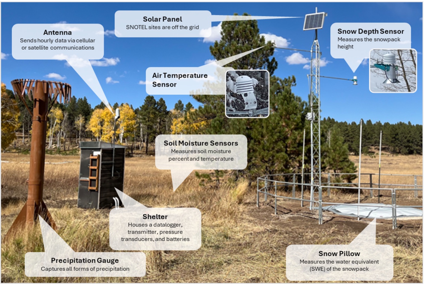
The components in a typical SNOTEL station. Source: Natural Resources Conservation Service.
At its core, the dispute over hotspots reflects a long-standing divide in hydrology. One camp relies on statistically based approaches, such as using a select number of “index” sites to measure the snowpack and predict streamflow based on historical records. Another paradigm favors physically based methods that employ the laws of physics to account for the coming and going of water molecules in a basin, such as using aircraft to map the snowpack.
“Historically, we’ve increasingly been moving toward physically based approaches in hydrology,” Molotch said. “At some point, we may have a complete passing of the baton toward physically based approaches. I don’t know if and when that will be in our future, but I think that that is the way that things are migrating over time.”
Small said that ASO data “will give you the total number of water molecules in a basin” if you accept their snow density model, but that’s only part of the story. To predict streamflow, forecasters must account for other factors, including how much water is lost to the atmosphere when it evaporates, transpires from plants or converts directly from ice to water vapor, a process known as sublimation. Soil moisture and groundwater levels also shape the hydrologic cycle.
“The total volume of water in the snowpack is not hugely predictive of streamflow compared to what you get from the hotspots, and that has to be the case,” Small said. “If you have any variations in the basin from evapotranspiration or soil moisture storage or groundwater storage—that has to be the outcome. And I think we probably should have said that in the first sentence of the paper.”
Using an “all of the above” approach
Denver Water describes the snowpack in the mountains west of the city as the utility’s biggest reservoir. To supply its 1.5 million customers, Denver Water uses a variety of techniques to track the snowpack, including manual measurements, automated SNOTEL stations, ASO flights above key watersheds and satellite data that is blended into reports that Molotch and colleagues generate at the University of Colorado Boulder.
“We take an all of the above approach,” said Taylor Winchell, climate change adaptation program lead at Denver Water. “We think that all of these systems really have their place and are all important in giving us the full picture of the snowpack that we’re hoping to gather to help us make confident decisions.”
Each type of snow monitoring has its benefits and limitations. “They each fill a gap that the other doesn’t,” Winchell said.
The SNOTEL system, for example, can provide hourly or daily readings of the snowpack and offers long historical records, but it only measures conditions at a single point. The stations also tend to sit in mid-elevation clearings that are easy to access, so they don’t necessarily reflect the diversity of the West’s terrain and overlying snowpack.
“We often don’t have measurements at those higher elevations, and it kind of leaves a blind spot in our understanding of the snowpack,” Winchell said.
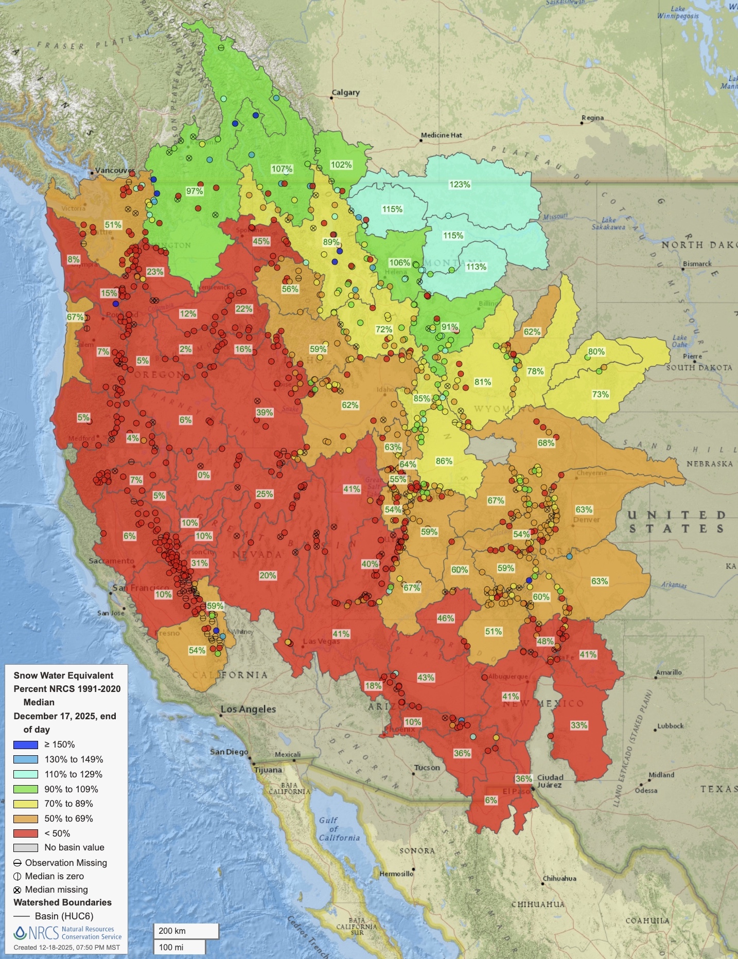
Snow water equivalent on Dec. 17, 2025. Source: Natural Resources Conservation Service.
Like many water providers in the West, Denver Water has been grappling with a growing mismatch between snowpack levels and the amount of water that eventually reaches streams and rivers in the spring and summer.
“We just don’t quite expect the same amount of streamflow production nowadays as we would’ve historically with similar levels of snowpack,” Winchell said, noting the influence of soil moisture levels, evaporation and sublimation. “We can’t go off the same assumptions that we might’ve had in the past, and so every year it creates this kind of new and intensified challenge to understand how the snowpack is going to translate into streamflow.”
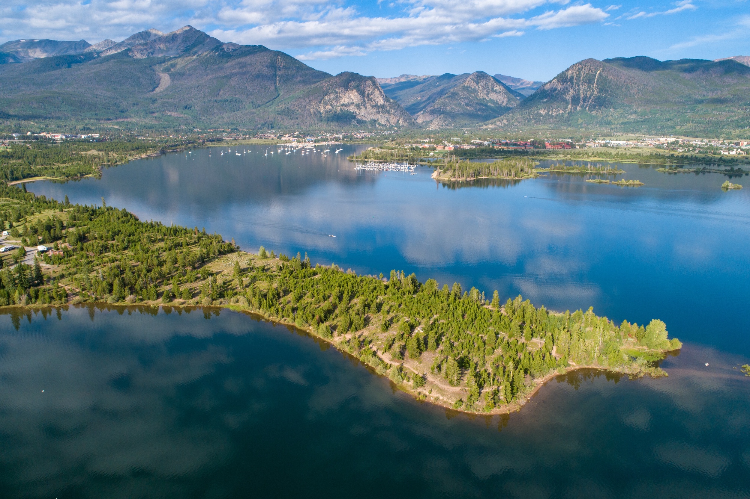
Denver Water has used ASO data since 2019 and spent an average of about $200,000 per year on the airborne surveys. That first year, ASO surveyed the watershed around Dillon Reservoir—a linchpin in the utility’s supply that collects runoff west of the Continental Divide so that it can be pumped through a 23-mile tunnel bored beneath the Rocky Mountains and reach the east side of the Divide, where most of Colorado’s population lives.
“With those flights, we saw kind of immediately the high value of this information for our decision-making processes,” Winchell said. ASO found the snowpack was bigger than what Denver Water expected, Winchell said, so the utility “immediately increased outflows from Dillon Reservoir so that we’d be able to capture that snowpack without flooding downstream of the reservoir.”
ASO’s high-resolution data is valuable for Denver Water because it “fills in the gaps between those station measurements,” Winchell said.
In the large watersheds that supply the utility, “you can have storms and snow patterns that are quite different from one side of the watershed to the other, and you might have different diversion systems in each part of that watershed,” Winchell said. “You might have had a forest fire in one part of the watershed that impacts the snowmelt within that sub-watershed. So really being able to have that detailed picture of the full watershed, we do find value in that.”
But the cost of airborne surveys remains a critical issue.
“It’s still been a struggle year over year to get the funding needed even to fly what we see as the baseline number of useful flights,” Winchell said. “There’s still a lot of room for both adding additional flights in watersheds that are already being flown, as well as conducting ASO flights in watersheds throughout the state that don’t currently have ASO flights.”
Costs versus benefits
In Colorado, CASM was formed in part to secure additional funding to expand ASO flights above the state. CASM’s annual budget in 2025 was $4.5 million, with state funding accounting for 52% and the rest from federal, local and other sources.
The U.S. House of Representatives recently passed bipartisan legislation that would reauthorize and update the federal Snow Water Supply Forecasting Program “to incorporate modern technologies, including LiDAR and satellite imagery, to improve the accuracy of snowpack and water-supply predictions,” according to sponsor Jeff Hurd, R-Colo.
Backers of airborne surveys acknowledge that flights aren’t cheap—two flights over a basin can cost a couple of hundred thousand dollars per year—but they say the data can generate far greater benefits. A more precise read on the snowpack can prevent flooding and allow water managers to devote excess supplies to groundwater recharge. Conversely, advance warning of shortages can help avoid disruptions for both agricultural and urban water users.
“The value of these data can be off the charts,” Deems said, with some case studies from California showing a return on investment between 50 and 200 to one.
In the headwaters of Northern California’s Feather River, which supplies the California State Water Project, Deems said ASO’s data improved water management. In 2021, the year before ASO’s flights began, water managers “thought they had a decent snowpack,” Deems said, but they had to dramatically scale back allocations, eventually to zero, “because the water just didn’t show up,” causing significant impacts to farmers and other water users.
“The following year, we started flying in the Feather River,” Deems said. “Our February flight showed that they had half the water they thought they had, so it looked like essentially a repeat of the prior year, except this time they knew about it in February, rather than finding out about it when the water didn’t show up at the stream gauge in July.”
ASO flights have helped Denver Water predict runoff into Dillon Reservoir, which collects water before it’s pumped through a 23-mile tunnel under the Continental Divide to supply the utility’s customers. Photo by Ted Wood/The Water Desk.
The future of snowpack monitoring
Looking ahead, the stakes are only growing for snowpack monitoring and streamflow forecasting as the climate warms and the West continues to add new water users.
Despite their varying views, snow experts agree that a diversity of approaches will be needed in the foreseeable future. The hotspots study authors see value in the ASO flights, and backers of airborne surveys would like to see more SNOTEL stations.
“We are first in line to advocate for more observations, especially if they can be in environments that are different than the current set of observations covers,” Deems said.
The question, Wobus said, is “how do we use combinations of advanced monitoring technologies like lidar and satellite observations and things like that in a framework that will help you improve water supply forecasts without having to measure everything?”
“There’s a lot of room to improve the economics of snow monitoring,” Wobus said. “If we’re talking about the difference between flying every basin once a year and getting total coverage at a cost of, let’s say $10 million a year for the state of Colorado, versus adding a few more SNOTEL stations in a few places where you really need it—there’s a lot of real estate in between those two things.”
Snowpack monitoring in the Sierra Nevada in 1960. Nowadays, skis are wider, and researchers typically don’t wear jeans into the backcountry, but the technique for manually measuring the snow’s water content has changed little. Source: California Department of Water Resources.
When ASO maps the snowpack in an entire basin, its aircraft flies back and forth in a pattern often likened to mowing a lawn. Small and Wobus said that one way to save money would be to do more limited flights and use machine learning—a type of artificial intelligence—to extrapolate the results.
“If you fly one strip and combine that with a machine-learning model, you can get like 98% of the way there, and you can save a whole boatload of money,” Wobus said. “You could just fly a straight line across the state of Colorado and then turn around and fly back and get almost as much information as you’re getting by flying like a lawnmower back and forth across the basin.”
But some backers of airborne mapping are skeptical.
“That would be bringing a lack of confidence back into the system, and that’s a difficult thing to ask a water manager to accept, especially after we’ve shown what’s possible,” Deems said.
Drones have also become part of snow hydrologists’ toolbox. While the hotspots paper argues that using lidar technology mounted on drones would be less costly than flying large aircraft, that approach “does not reflect the logistical and financial realities of operating such a program in Colorado’s mountain environments,” according to CWCB.
“Drone-based lidar systems require extensive permitting, frequent flights due to limited range and battery life, and highly trained operators to meet accuracy standards comparable to crewed aircraft,” CWCB wrote. “No program currently exists with the resources, planning, or data management structure to deploy drone surveys at the basin scale needed for operational water forecasting.”
For many snow hydrologists, the holy grail would be to launch a dedicated satellite that could look down from space and estimate the water content of the snowpack around the planet using, for example, microwave sensors. But that’s literally a heavy lift.
“There’s lots in the works,” Deems said. “But the global solution is pretty elusive, and folks have been trying to do this for decades.”
The technology exists today to measure snow water equivalent with a satellite, “but not everywhere and not all the time,” Molotch said. One major obstacle is that satellite monitoring may not work when the snowpack is wet, which is especially vexing in the warmer, maritime snowpacks near the West Coast.
“Snowpack conditions in the Sierra Nevada of California can be wet at any time of year between storms when the sun’s out and it starts to warm up,” Molotch said. “As the climate warms, we would expect that snow wetness will be increasingly problematic for microwave remote-sensing techniques. But I think on the positive side, if we’re able to make snow water equivalent measurements in some locations, that helps us provide information for models that can fill in the gaps.”
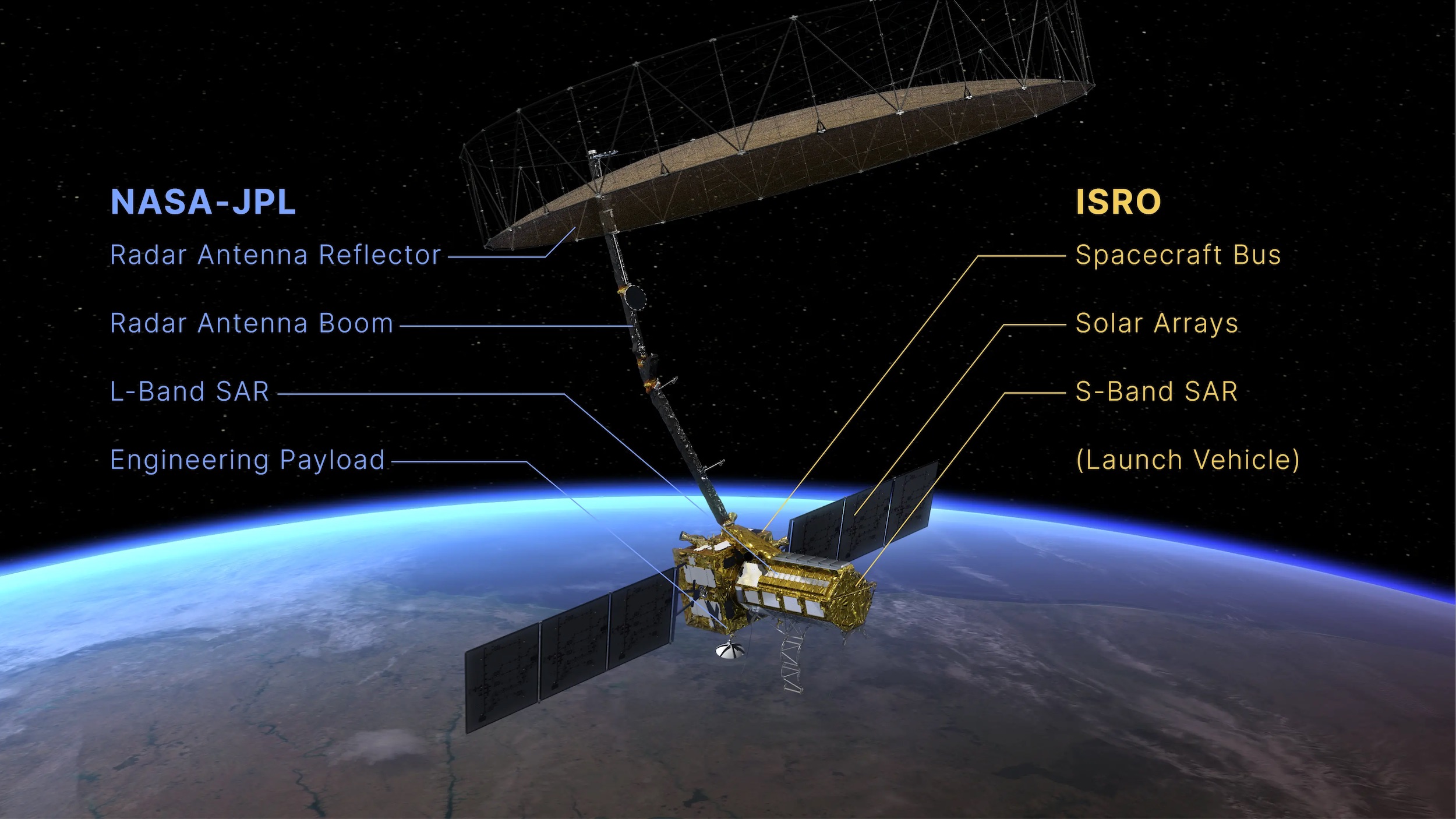
In July, NASA and India’s space agency launched NISAR, a new radar satellite built to track how Earth’s surface is evolving. While not dedicated to monitoring the snowpack, the mission will measure changes in snow, glaciers, sea ice, ice sheets and permafrost. Operating day or night, NISAR’s signals can penetrate clouds, and the satellite will observe nearly the entire Earth’s surface twice every 12 days.
Illustration of the new NISAR satellite. Spacecraft hold promise for measuring the West’s snowpack but face challenges of their own. Source: NASA.
The NISAR mission “introduces a promising avenue for cost-effective, large-scale snow depth and snow water equivalent” estimates, according to a January study in Frontiers in Remote Sensing. A 2024 paper in Geophysical Research Letters concluded that NISAR offers a “promising path toward global snowpack monitoring.” While errors increase in forests with a denser canopy, the 2024 study said the satellite “may be feasible for snowpack monitoring in sparse to moderate forest cover.”
What research and data would deepen understanding of the snowpack in the future?
“Where to begin?” Winchell said with a laugh.
In addition to having more manual measurements, more SNOTEL stations, more ASO flights and even a citizen-science effort, Winchell said better knowledge of snowpack temperatures would be helpful to Denver Water because that “provides a really strong indication of when the snowpack is ready to melt.” Additional soil moisture data could also improve the utility’s forecasts of how the snowpack translates into streamflows.
“The field of snowpack research is just a crucial field with really lots of exciting work ahead, especially as these new, really high-value, high-accuracy datasets are coming into play,” Winchell said. “I think decades into the future we’ll wonder how people really went about managing the snowpack water supplies without this information.”
Aerial view of the Rocky Mountain snowpack over central Colorado on Dec. 3, 2024. Photo by Mitch Tobin/The Water Desk.
This story was produced and distributed by The Water Desk at the University of Colorado Boulder’s Center for Environmental Journalism.
Editor’s note: Two of the co-authors of the hotspots paper and one of the critics of the study are affiliated with the University of Colorado Boulder. The Water Desk is also based at the University of Colorado Boulder but operates as an editorially independent journalism initiativeand is solely responsible for its content.
Elephant Butte Reservoir, along the Rio Grande near Truth or Consequences, N.M., in August 2022. (Mitch Tobin/The Water Desk)
This program is no longer open to applications.
The Water Desk is excited to announce an in-person training and workshop for journalists interested in covering the Rio Grande watershed to be held in El Paso, Texas.
The Rio Grande faces significant challenges: climate change, aridification, pollution, development, population growth, invasive species and more. The river forms a portion of the U.S.-Mexico border and is a critical water supply for three U.S. states—Colorado, New Mexico and Texas. As supplies shrink and tensions ramp up, litigation among the river’s users continues to make headlines. Tense diplomatic relations between the U.S. and Mexico are affecting the Rio Grande as well.
To equip journalists to better understand the river’s current and future challenges, The Water Desk will host a training program for journalists in El Paso, Texas, on March 25-27, 2026. Participating journalists will hear from legal experts, tribal leaders, environmental advocates and other speakers who can shed light on the Rio Grande.
We will select up to 15 participants who represent diversity in geography, race, gender and journalistic medium. Travel, lodging, meals and other expenses will be covered for all attendees. Additional funding for story coverage after the training will be made available. The program will begin the evening of March 25 and conclude in the afternoon on March 27.
The Thornburg Foundation, a Santa Fe-based family foundation, is providing the financial support to make this training possible, while the program’s content is the sole responsibility of The Water Desk. Deadline for applications is Monday, January 12, 2026 at 11:59 pm Mountain.
Testimonials from journalist-participants at our 2025 Rio Grande workshop, held in Albuquerque, New Mexico:
“The most valuable part of the workshop was the boost of inspiration and support I got from spending 2.5 days with other passionate journalists and advocates.”
“I loved the collaboration opportunities, I loved the speakers, I loved the venue, I loved the opportunity. The whole thing was the best part of my journalistic year and was truly the jump start I needed.”
“I came for the information, but found that in the end the most valuable part of the workshop were the new relationships with fellow journalists I came away with.”
A welcome sign in Price reminds residents to save water, Sept. 30, 2025. Consistent messaging is likely one of the reasons Carbon County has become a leading county for conservation in Utah. (David Condos/KUER)
Water Desk Grantee Publication
This story was supported by the Water Desk’s grants program.
One size fits all. That’s great for hats in the Zion National Park gift shop but not for water conservation goals.
So at the start of this decade — and for the first time — Utah figured it would ditch that statewide approach and set goals that account for regional differences in water supplies and uses.
After all, life in Salt Lake County isn’t like living in the eastern rural counties along the Colorado border. Water, as it turns out, “is very hyperlocal,” said Candice Hasenyager, director of the Utah Division of Water Resources.
To meet a statewide conservation goal of 16%, the decade-long effort aims to reduce the water used in homes, schools and businesses. Individual targets were set for each county to make it happen. Farm irrigation isn’t part of it — there are other ways to save water there. While it’s true that most of Utah’s water goes to agriculture, “ag is not always where the people are,” Hasenyager said. So, how Utahns conserve in cities and towns still matters.
Halfway through the initiative, however, the results are mixed.
“There are some areas that have already exceeded the goals, which is great,” Hasenyager said. “Then there are other areas that we know need to do a lot more work.”
Fifteen of Utah’s 29 counties have reached their annual 2030 goals at least once in the past two years. That list of success stories ranges from the most populated county, Salt Lake, to the least, Daggett. Washington, Iron and Tooele counties hit their targets in at least one recent year, too. But 14 other counties have not, including Weber, Juab and Box Elder.
Four rural counties in Utah’s Colorado River Basin — Carbon, Duchesne, Uintah and Wayne — are a microcosm of the state’s successes and struggles.
Take Carbon County and its goal is to use an average of 239 gallons per person per day by 2030. That would be an 11% decrease from the 267 gallons it used in 2015, the state’s baseline year for the reduction targets.
In 2024, the county used 197 gallons per person per day, the fifth lowest rate in the state. That’s even less per capita than urban Salt Lake and Utah counties. So, they beat their goal last year.
Uintah met its goal in 2023, years ahead of the deadline.
It’s a different story for Duchesne and Wayne. Both are using more water than they did a decade ago.
Talking about saving water matters
Seemingly similar counties — like, say, Duchesne and Uintah or Salt Lake and Weber — have seen very different outcomes. The reasons behind such disparities range from money to lot sizes to local economies.
It also comes down to the priorities of local leaders and how they talk about saving water. Ultimately, that trickles down to influence people’s behavior.
“People need to be convinced there’s a need and a purpose for undertaking water conservation activities,” said Joanna Endter-Wada, a Utah State University water policy and sociology of conservation researcher.
It can take time — years — for the message to sink in and shift a community’s culture. So, how long and how vigorously a county has emphasized conservation can make a difference.
Wayne County uses more water per person than any other part of Utah, in excess of 900 gallons per capita per day.
That doesn’t surprise Mickey Wright, a retired software engineer who’s the mayor of Torrey. It’s a town of 332 people near Capitol Reef National Park.
“I think our focus hasn’t been enough on water,” Wright said. To him, the biggest barrier to conservation is shifting from an individualistic to collective mindset.
“We don’t think of ourselves as being that significant, that my little bit doesn’t have that much effect.”
Mayor Mickey Wright walks across a patch of grass near Torrey’s city office, Sept. 29, 2025. The town plans to replace the grass with desert landscaping next year to start setting a better example with water conservation. (David Condos)
Wright grew up in rural southern Colorado and remembers a life of water rationing. When he first came to Utah to meet his wife’s family, he was struck by all the green lawns.
Now, he wants Torrey to start setting a better example.
Outside the old fire station repurposed as the city office, Wright walked across a patch of grass whose days are numbered. By next spring, he said it’ll become a high desert garden with native grasses and flowers. The idea is to inspire residents and businesses to do something similar.
Wright remains hopeful Wayne County can turn things around and hit its goal in the next five years, but he acknowledges change can be difficult. When he pitched a grass removal rebate program earlier in his term, he had a hard time getting support.
But the alternative to conservation is expensive. Torrey will need more water as it grows, the mayor said, which would require pipeline projects to bring it in that could easily top $5 million.
“The less water we use, the less millions we’ve got to go find,” Wright said. “That’s the argument I’ve got to make.”
People are trying to start a similar conversation to the north of Wayne in Duchesne County. It uses the sixth most water per capita in Utah and would need to cut back by more than 40% to reach its 2030 goal.
They’re part of the Central Utah Water Conservancy District, which stretches from Orem to the Colorado border. That’s a lot of ground to cover, so Savannah Peterson, one of the district’s water conservation programs coordinators, knows she needs to speak everyone’s language.
“Using words like ‘xeriscaping’ or ‘waterwise’ in more urban areas is a really popular thing. But in our rural areas, we talk about ‘drought resiliency,’” Peterson said. “We’re trying to meet people where they are in terms of their understanding of the water situation.”
Savannah Peterson of the Central Utah Water Conservancy District checks on flowers growing in a waterwise garden outside the district’s office in Duchesne, Oct. 3, 2025. (David Condos)
The district already offers rebates to help Duchesne residents replace leaky toilets, upgrade sprinkler controls or remove thirsty lawns. But folks often think of those programs as a city thing, and they may not even realize it’s available to them.
“Water districts have sometimes been seen as the bad guy,” she said. “But we want to make sure that people know we’re a resource.”
Over the past decade, his team has worked to dispel common myths, like the thought that conserving locally means sending more water downstream to California. The reality, he said, is that saving water stores it in Uintah’s reservoirs.
As drought set in this spring, his district raised its rates and told customers why.
“People don’t like being told what to do, and so my message to that is: We don’t tell them what to do. We explain the situation and let them pick,” Goodrich said.
That meant choosing between paying a higher bill or trying to cut back, he said, “but if they don’t understand the underlying reason for it, they’re not going to do it.”
Uintah’s local efforts appear to be paying off. It hit the state’s 2030 goal in 2023 with 209 gallons per capita per day, before slipping back above the target line in 2024.
Between the higher water rates and a new outreach plan of radio ads, text messages and flyers, Goodrich said his district has cut water use by roughly another 20% this year.
It’s great to see how far Uintah has come with conservation, Goodrich said, but it’s no time to rest on their laurels.
“We are doing a pretty good job. We can do better,” he said. “This year was the year that we said we have to do better, because we just don’t have the water.”
Ryan Goodrich of the Ashley Valley water district stands next to Ashley Creek, Oct. 2, 2025. This tributary of the Green River provides water for communities around Vernal, but it has run low this year because of drought. (David Condos)
The size of a community’s wallet matters, too
Clear, consistent communication isn’t the only thing that can help residents save more water. Small towns may have just one person managing their water system, Endter-Wada said, while bigger cities have a whole staff of water conservation experts.
The more resources a community has, the more likely they’ll be able to implement conservation efforts such as lawn replacement incentives and hiring employees to manage those programs.
“At the end of the day,” Hasenyager, the state water director, said, “conservation costs money.”
There are real barriers in places with fewer people and smaller budgets. That’s the case in Myton, a town of 662 in Duchesne County.
Water is so vital to life in this part of northeast Utah that Myton showcases a ragged wooden pipeline from the early 20th century in its museum. But even the pipes that carry Myton’s water into town today have problems. Many are nearing 50 years old and leak badly, Mayor Kathleen Cooper said. Those pipes routinely lost more than a fifth of the town’s water over the past decade.
But Myton doesn’t have the money to replace them.
“I don’t know who you blame,” Cooper said. “All I know is that I need water pipes, and we only have 600 people.”
Myton Mayor Kathleen Cooper stands next to an old water pipeline in the town’s historical museum, Oct. 1, 2025. She says many of the town’s current pipes leak badly, but Myton doesn’t have the money to replace them. (David Condos)
Around a quarter of the town’s residents live below the poverty line. That’s more than triple the state average. It also overlaps with Ute tribal land and around one-sixth of its residents are Native.
“We don’t have a bunch of oil barons living in Myton that could raise our property rates so that we would get more money,” Cooper said. “So, we have to rely heavily on grants.”
And those federal funds dwindle by the second, she said.
On top of that, small towns face a competitive disadvantage. If they apply for grants, Endter-Wada said, they’re often up against urban and suburban communities that hire outside consultants to juice up their proposals.
When rural areas do get their hands on the money, it’s easy to see the impact. Look at the town of Helper, in Carbon County, just south of Duchesne.
Along a highway in Price Canyon, Mayor Lenise Peterman rested her hand on a rusted pile of scrap from a pipeline that brought water to town for 70 years. Before they replaced it, the town of 2,680 people lost about half its water before it ever made it to someone’s kitchen sink.
Helper made it happen thanks to $3.4 million in federal post-pandemic funds. That’s nearly double the town’s entire annual budget, Peterman said.
“We were fortunate to get that funding and to make it happen,” she said.
“We knew we weren’t doing that well,” the mayor added. “It wasn’t that we weren’t trying, it was that the infrastructure was failing us.”
With the new pipe installed, Helper can focus on next steps for saving more water. For example, the mayor wants to start a program in the local schools to teach kids about conservation.
The project to replace Helper’s leaky water pipeline cost more than twice the town’s annual budget, said Mayor Lenise Peterman, seen here at the project site Oct. 1, 2025. The water-saving project might not have happened without millions in federal funds. (David Condos)
The nearby town of Price also has a leaky pipeline that’s nearly a century old. City council member Terry Willis said they recently snagged around $5 million in grants and $10 million in loans to replace it.
“When you have to say millions, it makes your heart beat a little bit and makes your stomach churn a little bit,” Willis said. “But it’s the reality of what it is.”
Price and Helper are both in Carbon County, which has already met its 2030 goal.
Between hotter, drier weather and concerns about the future of the Colorado River, there’s urgency for communities to keep going.
“We watch the climate change, and it has continued to change since I’ve lived here,” Willis said as she stood next to the Price River, which can dry up during drought. So, conservation has to be at “the forefront of everything we do. Because without water, the community will fail.”
Mayor Cooper said Myton has applied for federal and state checks, too. In the past couple of years, the town has gotten outside funds to replace water meters and launch an app for residents to check their water use.
She wants to do more, though. And hasn’t given up yet.
“I’m always hopeful,” Cooper said with a laugh. “You have to be in Myton. That’s all we have left is hope.”
Price city council member Terry Willis stands next to the Price River, Sept. 30, 2025. The river provides water for the city’s supply, but parts of it can dry up during drought years. (David Condos)
When water props up rural economies and larger homes
In 2023, homes were the top water users in Uintah and Carbon counties’ municipal districts. Most commercial, institutional and industrial customers didn’t come close.
Residential was also the leading user in every Wayne County district except one. That was in Torrey, Capitol Reef National Park’s gateway town, where the commercial sector used the most.
That likely points to one influencing factor: tourism. People staying at hotels, resorts and RV parks may use Torrey’s water, but they aren’t counted in its population.
Visitors spent $54.8 million in Wayne County in 2023, according to data from the Kem C. Gardner Policy Institute. That means tourism brought in $21,720 per resident — significantly higher than tourism’s relative impact in Duchesne ($2,581 per resident), Carbon ($4,309) or Uintah ($6,253).
Wayne has a small population, 2,543, and visitors could have an outsized impact on its per capita numbers. Still, a small number of residents hasn’t stopped neighboring Garfield County — home to 5,115 people and Bryce Canyon National Park — from decreasing its water use since 2015, while Wayne’s has gone up.
Duchesne may not have as much tourism, but it ranks high for fossil fuel extraction. In a 2021 letter to President Joe Biden, local leaders described the county as Utah’s top crude oil producer and No. 3 for natural gas.
In Duchesne’s Johnson Water Improvement District, industrial customers used 689,441,942 gallons 2023. That’s more than five times what the district’s residents used that year and nearly twice as much as all the homes in Roosevelt, the county’s largest city. On its website, the district says it provides a “substantial amount of water” to the oil and gas industry.
Other industrial uses, such as data centers and processing plants, can have similar impacts on water in rural areas, Endter-Wada said.
“So, it’s really not just a reflection on the individual behaviors of the residents in the area, but it reflects the economy as a whole,” she said.
When water props up the local economy, it is hard to cut back. That illustrates why it’s important to be cautious about the types of new industries Utah leaders welcome, Hasenyager said.
Large rural lot sizes also skew the data, Endter-Wada said, because more than half of Utah’s residential water gets sprayed onto lawns and gardens. If you have a family of five living on a small tract in the city, they’re likely to use less water than a family of five on a sprawling property in the country.
“Distribute that water use over a smaller population,” Endter-Wada said and “you’ll see greater gallons per capita per day numbers.”
Wayne has the largest average lot size in Utah, more than triple Salt Lake County’s, according to state data. Duchesne’s lot sizes are in the middle of the pack — similar to the average in Utah County and smaller than Uintah’s.
Another factor is that the state has to estimate much of Wayne’s water use, Hasenyager said, because there aren’t enough meters tracking the actual gallons. Installing measuring devices for all of Utah’s secondary water systems, which generally go to landscaping, is another state goal for 2030.
Until then, there may be some farm irrigation inadvertently counted with the county’s city water.
“I’m pretty convinced that [Wayne’s data] has agricultural water in it, and we need to try to dig into that,” Hasenyager said
The state is also digging into potential changes to the 2030 goals.
Right now, the target reductions are based on each county’s average water use from 2015. The state may soon use the average from 2015 to 2019 as the baseline instead. That change would bring Wayne and Duchesne closer to hitting the mark, but their 2024 water use would still be significantly higher than those updated goals.
Utah may also start using a percentage to reflect how close each county is to its goal, Hasenyager said, rather than the specific amount of water it uses.
Other changes have already happened. In 2025, the Legislature directed Utah’s five most populous counties to report their consumptive water use, rather than total water use. That allows a county to subtract return flows — the gallons that go back into the water system — from its sum and results in a lower per capita figure. This story relies on the total water use for those five counties rather than consumptive use to maintain a direct comparison with the counties’ data from 2015-2019 and with the data from the other 24 counties.
Despite around half the state’s counties falling short of their 2030 goals so far, Hasenyager said Utah is in a much better place than it was five years ago.
“There are more programs now than ever before that are encouraging water conservation from all different levels — from the state, from the districts, from the local water suppliers,” she said. “So, I’m really hopeful and confident that more of our counties will meet those 2030 goals.”
There’s no penalty for those who don’t meet their goals by the end of the decade. But communities who aren’t careful with their water, Hasenyager said, could face natural consequences in such a dry state.
Listen to this series by David Condos
Part 1
Utah has county-by-county water goals. Is your county hitting them?
Part 2
How we talk about conservation in Utah
Part 3
“At the end of the day, conservation costs money.”
Love storytelling? Curious about how water shapes life in the West? Want to work with a small team of journalists who are fascinated by the snowpack, rivers, reservoirs, and the stories behind them?
The Water Desk at the University of Colorado Boulder’s Center for Environmental Journalism is looking for a Spring 2026 Intern, and we’d love to hear from you.
As our intern, you’ll work alongside The Water Desk’s leaders, helping track water news, supporting reporting projects, writing your own stories, and contributing ideas to strengthen coverage of one of the West’s most important issues.
What you’ll do:
Dig into research for your own stories and our team’s special projects
Support our social media, website updates, and general communications
Help wrangle details for journalism training programs and workshops
Contribute to brainstorming sessions and team discussions
Bring curiosity and creativity to everything you do
What we’re looking for:
Strong writing skills and a sharp eye for detail
Genuine interest in journalism, water, climate, or environmental issues
A student who’s organized, comfortable working independently, and eager to learn
Bonus points if you’ve dabbled in reporting, photography, video, data analysis and visualization, or digital communications
This paid internship is open to CU Boulder students and offers flexible hours (approximately 10-15 per week) throughout the spring semester. It’s a great opportunity to build real-world experience in environmental journalism, storytelling, and digital media.
Ready to apply?
Fill out this online application, which asks for your résumé, a brief cover letter, and two work samples.
Come help us tell the story of water in the West.
Deadline for submissions: December 31, 2025 at 11:59 p.m. MT
A high-severity burn in Colorado’s Rocky Mountains. Wildfires are altering the snowpack, a crucial source of water in the West. Photo by Arielle Koshkin.
As the American West warms due to climate change, wildfires are increasingly burning in higher-elevation mountains, charring the watersheds where the region’s vital snowpack accumulates.
A new study has found that in the immediate aftermath of fires across the region, the snowpack disappears earlier in burned areas. This change can threaten forest health and affect the downstream farms, cities and species that rely on the snowpack for their water, according to other research.
Scientists who study the effects of wildfires on the snowpack and streamflows are finding that the story is complex and nuanced. The impacts can vary greatly across the West’s diverse ecosystems and topography. Plus, each wildfire burns differently, so the severity of the blaze is another critical factor.
While streamflow volume typically increases after a wildfire, the peak flows come earlier in the season, and the water may be clogged with sediment that can harm wildlife and water infrastructure.
The new study, published in the September 17 issue of Science Advances, used satellite data to track when the snowpack disappeared each season and examined how that timing changed after a fire burned through forests. The research also concluded that warming temperatures due to climate change will further accelerate post-fire melting.
In the first year after a fire, the researchers found that under average winter conditions, snow melts earlier in 99% of the snow zone. “Postfire snow cover loss is more extreme in relatively low-elevation, warm environments compared to that in high-elevation, cold regions,” wrote the researchers from the Colorado School of Mines and the University of Colorado Boulder’s Institute of Arctic and Alpine Research.
The loss of the forest canopy due to a fire can actually increase snow accumulation on the ground below because scorched trees that are missing branches and needles intercept fewer falling snowflakes. But opening up the canopy changes the flow of energy in the forest by exposing the underlying snowpack to more solar radiation that can melt the snow.
Wildfires also cause soot and darkened debris to fall on the snowpack, which reduces its reflectivity, allows more heat to be absorbed and leads to quicker melting. Burned forests are also more susceptible to wind, which can further erode the snowpack.
“It’s basically just a big energy balance puzzle, but it seems like that increase in sunlight and decrease in the reflectivity of the snow are both leading to (an) earlier snow disappearance date,” said lead author Arielle Koshkin, a doctoral candidate in hydrologic science and engineering at the Colorado School of Mines. “Even if we do see more snowfall in the forest, it’s not overriding those energy balance changes.”
The study notes that previous research has found that the acreage of Western forests burned in the seasonal snow zone increased by up to 9% annually between 1984 and 2017, with the biggest rise in burned area occurring above an elevation of 2,500 meters (8,202 feet).
“Fire is burning higher and higher in elevation, which increases this overlap between where burned forests are and where it snows,” Koshkin said.
Stephanie Kampf, a professor of watershed science at Colorado State University who wasn’t involved in the study, said the findings are “pretty consistent with prior research” showing that snow disappears earlier after a fire and that lower-elevation locations with more “transitional” snowpacks are more vulnerable. “This study shows it really nicely with a big dataset,” Kampf said.
Climate change speeds up melting
Looking ahead, the authors project that post-fire melting will accelerate further as the West gets hotter due to rising atmospheric levels of greenhouse gases. If warming increases by 2 degrees Celsius—something that’s possible by the middle of the 21st century under some emissions scenarios—“73% of the snow zone would experience more extreme earlier postfire snowmelt compared to historically average conditions,” according to the paper.
“Under two degrees (Celsius) warming, the areas that already showed large changes are going to show even larger changes,” Koshkin said. “That warming is going to really have (an) impact on those warmer snow climates. So think maritime, Cascades, Sierras, comparative to the higher, colder, Rocky Mountain West.”
Previous research has also looked at what happens to the snowpack after a fire and found that the snow disappearance date moves up four to 23 days. Some of those studies have used ground-based observations, but the papers typically focused on one to three fires. Other research has examined snowpack readings from the automated SNOTEL network, but those snow sensors are usually placed in gaps in the forest canopy and may not capture the diversity of the West’s landscapes.
This new study relies on images captured by the MODIS instruments aboard two satellites to provide a Westwide look at wildfire’s effects. Currently, satellites cannot measure the water content of the snowpack, known as the snow water equivalent. But repeated satellite imagery can detect whether snow is present on the ground, allowing researchers to measure when the snowpack disappears during the year.
“I was really interested in seeing if we could leverage remote sensing to look at it on a pixel-by-pixel scale across the whole Western United States to really try to understand, are we seeing the same responses in the Pacific Northwest as in Colorado?” Koshkin said.
Each pixel in the MODIS satellite imagery represents a square on the ground with 500-meter (1,640-foot) edges. That’s a somewhat coarse resolution for measuring the snowpack, which can vary dramatically over very short distances, but the satellites provide daily or near-daily coverage.
While satellite data offers broad coverage of the region, it has significant limitations.
“The satellites can’t really peek underneath the forest canopy,” said Anne Nolin, a professor in the geography department at the University of Nevada, Reno, who wasn’t involved in the study. (Koshkin is a former student of Nolin’s.) “The other issue is that the satellite data can’t measure snow at times when there’s rain occurring or anytime there’s cloudiness. And so if you have a rain-on-snow event that’s changing your snowpack, which we’re having more and more, and which we would anticipate to occur more frequently, then you’re probably missing short-term changes in snowpack.”
Nolin said that the satellite-based estimates of the snowpack were “likely to be inaccurate in places where you have remaining forest, and especially in low-elevation snow zones and under warmer winter conditions.” That’s because previous studies have found that in warmer forests, the snow melts off under the canopy early, but it’s retained in the gaps between the trees, so the algorithm used to process the satellite imagery can overestimate the amount of snow in the pixel. “There’s less snow there than you think,” Nolin said.
Stark regional differences
Elevation, temperature, burn severity, vegetation type and the amount of incoming solar radiation are among the drivers explaining when the snow disappears. The variability of these factors across the West may help explain why previous studies have found such a wide range in the timing of the snow disappearance date.
“Everywhere we looked was disappearing earlier, but there were these kind of hotspots that disappeared way earlier,” Koshkin said. “I think the disruption in streamflow from these earlier melting-out pixels will be much more significant in Oregon, Washington and California.”
Wildfires had the biggest effect on the snowpack during the first five years after the blaze. In the first year after a fire, the snow disappearance date advanced by an average of 3.3 days. That might not sound like much, but the figure is just an average for the entire West—in some parts of Northern California and Oregon, the snow disappeared up to two weeks earlier.
Over time, the effects of fire declined. Ten winters after a blaze, for example, the average snow disappearance date moved up by less than a day.
While the advance of the snow disappearance date was most pronounced at lower elevations, the snowpack actually persisted slightly longer in some burned areas in Colorado and Utah, where the colder temperatures at higher elevations can insulate the snowpack from changes.
The finding that some higher elevation locations had a later snow disappearance date “would definitely be something to explore because everything that we know so far suggests that snow disappearance should be earlier after a fire,” Kampf said.
Higher elevations may be less vulnerable to an early disappearance of the snowpack due to late-season storms. “Here in Colorado,” Kampf said, “we get a fair amount of spring snow, and so that’s one of the reasons why we’re not as sensitive because sometimes that snow just comes in May and it resets everything and you don’t see the big change in snow disappearance date.”
Another factor in explaining the regional differences is the West’s diversity of vegetation. “The forests are different in places that are colder, so you have different tree species and different densities of forest and different ecosystems in general,” Nolin said. “The northern tier of states and the high country—that’s where you would be probably seeing the least amount of change. It doesn’t mean, though, that you have the least amount of fire because some of these places, especially in places like Idaho and Washington state, have significant amount of fire, and there’s some interesting studies that have shown earlier snowmelt in those locations as well.”
A large burn scar in the Northern Rocky Mountains. Post-fire changes to the snowpack vary significantly across the West’s diverse landscapes. Photo by Arielle Koshkin.
How wildfires change streamflow
Previous research has found that wildfires can significantly alter the timing and magnitude of runoff in burned watersheds, but scientists are still unraveling the details.
“If you burn down the forest, you don’t have as many trees that are using that water,” Nolin said. “You probably expect the streamflow to be earlier because the snow’s melting off earlier.”
Fires can not only kill trees and ground cover that would absorb water—they can also eliminate organic material in the soil, which causes the ground to become more water repellent and makes the snowmelt more likely to run off into streams.
A 2022 study that examined 72 forested basins that burned across the West found that average streamflow was significantly higher after a wildfire for an average of six years. The increase in streamflow was greater in areas where the extent of wildfire was larger. That study also found that the annual acreage burned by wildfires in the West skyrocketed by more than 1,100% from 1984 to 2020.
Kampf said more research is needed to understand how streamflow changes after a fire. “We don’t have all those interactions figured out yet, but there have been some studies that have shown that streamflow actually decreases after fire,” Kampf said. “We certainly know it will affect streamflow timing, but the amount of streamflow we’re less sure.”
Fire intensity is one key determinant of subsequent streamflow.
“If the forest is totally torched, then the increased solar radiation that’s coming into the snowpack is going to have a much bigger effect than if the trees still have live branches on them,” Kampf said. “Similarly, when you get down to the soil, if the soil is totally burned to a crisp, then its infiltration impacts will be much greater than if a lot of the litter and other stuff in the soil is still there.”
Nolin said she would have liked to see the authors distinguish between areas of high, moderate and low burn intensity.
“When you see photographs of burned areas, we tend to show the photos that are most dramatic with just charred trunks that have (been) left behind, but in fact, most fires are mainly low to moderate burn severity that maintain the forest canopy,” Nolin said. “To not distinguish between different burn severities and to indicate that it’s all about the canopy being burned off and all of this carbon shedding on the snow—I think that stretches the results.”
The speed of vegetation recovery also shapes how the snowpack and streamflows respond to wildfire over time.
“If it’s a forest type where the vegetation can respond quickly and come back, that’s going to be a really different response than if the vegetation is slow to grow,” Kampf said. “Here in Colorado, we have some fires where it’s not coming back as forest at all, and where there are just no seedlings, and so we would expect the fire effect on snow to persist for a long time because we just don’t have trees coming back.”
The post-fire effects on streamflow tend to be localized, so it can be difficult to detect their effects on major river basins.
“Even though the fires we’ve been experiencing have been really large, they’re still not huge compared to the size of the watershed as a whole,” Kampf said. “If you looked at something like the Colorado River Basin, it might be hard to detect the fire effect on the flow because there’s such a huge area that’s contributing to that flow. So in terms of how water is managed in forecasting and dam operations, I don’t think we’re there yet in terms of knowing how to account for fire.”
A major worry for water managers is the threat of high-intensity fires burning through dense stands of forest in the watersheds above their systems.
“Those are places that water managers are concerned about because if the forest burns, then they experience problems with post-fire erosion and sedimentation and harms to water infrastructure, so it’s kind of a different side of the water management issue,” Kampf said.
Impacts on ecosystems
Besides posing challenges for water managers, wildfires can have profound effects on wildlife and forest health.
For aquatic ecosystems, “having a shift in the timing of when flow is coming in could also have an impact,” Kampf said, but “probably the greater impact is when that flow is bringing in with it a lot of sediments that are changing the habitat more profoundly.”
More rapid melting of the snowpack after a fire can also lead to a longer dry season for forests.
“If the snow disappears earlier, plants will start greening up sooner,” Kampf said. “If they’re not getting a lot of summer rain, they may find drier conditions later in the growing season that can stress plants.”
In addition to snow disappearing earlier due to fires, Nolin said the weather in November is getting drier. “If you have an earlier snow disappearance date and a later snowfall date, that dry season’s really getting quite a bit longer, and so it means that you have a decline in forest health and you also have an increase in the potential” for a longer fire season, Nolin said.
How burned ecosystems will respond to fire remains an open question as the climate continues to warm. In many parts of the West, decades have passed since flames swept through a forest, but trees have yet to return.
The burned trees may be centuries old, “and the climate was different than when those little seedlings sprouted and became the big trees that ultimately were involved in the fire,” Nolin said. “They grew initially under a different climate, and we don’t have that climate anymore, so we might see a lot more shrubs.”
Nolin said the paper “used a very simplistic approach to looking at future impacts on snow” by only examining what will happen under 2 degrees Celsius of warming. Climate change will also alter such factors as relative humidity and precipitation, so including these other effects “would’ve been more nuanced and perhaps a little more supportable,” Nolin said. She would have liked to see the results for various temperature increases up to 4 degrees Celsius, noting that mountains are warming faster due to climate change, and a key question is whether rain or snow will fall under warmer conditions.
“Just having a single temperature change to look at helps us understand the impacts of temperature, and that’s great, but there is a lot more to be done in this area,” Nolin said.
This story was produced and distributed by The Water Desk at the University of Colorado Boulder’s Center for Environmental Journalism.