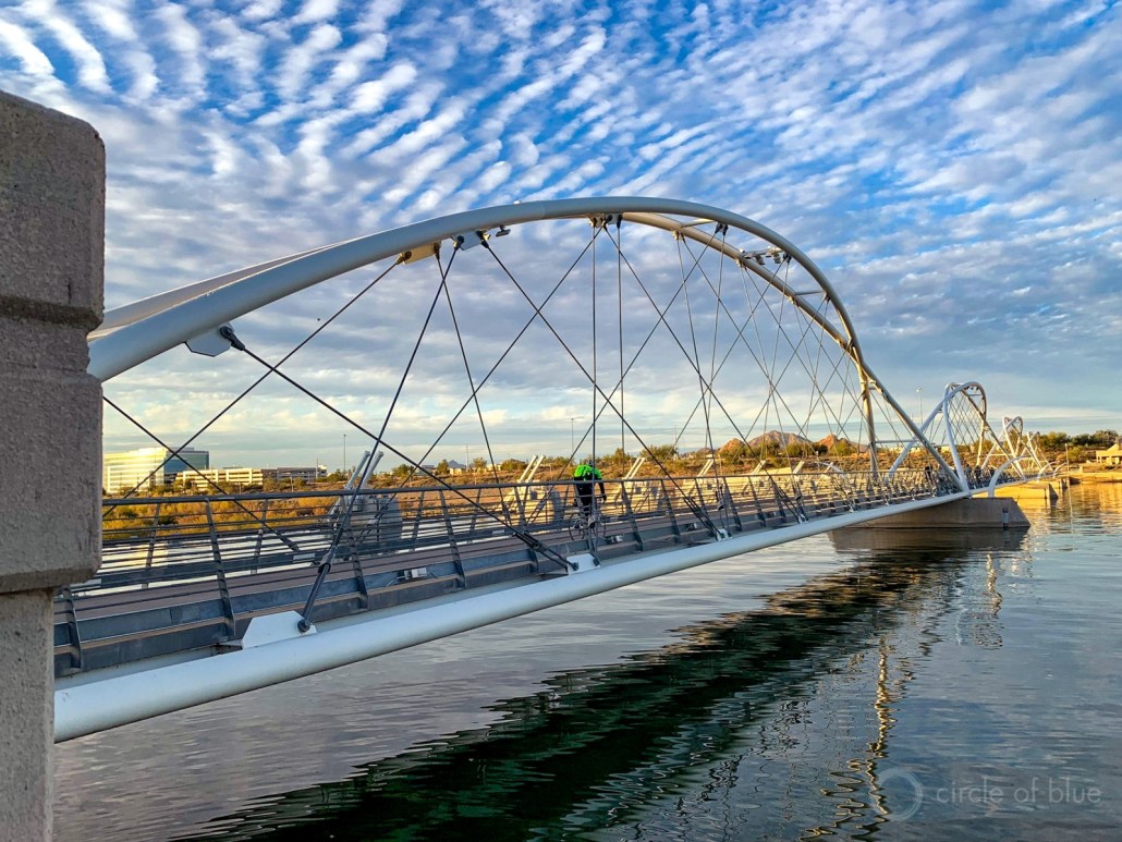
Construction workers build a single family home in Castle Rock. The community needs new surface water supplies to reduce its reliance on non-renewable groundwater. Credit: Jerd Smith
Douglas County officials said Tuesday they would not use their COVID-relief funding to help finance a controversial $400 million-plus proposal to export farm water from the San Luis Valley to their fast-growing, water-short region.
In a statement the commissioners said the federal rules would not allow the funds to be spent to help finance early work on the proposed project, and that it faced too many legal hurdles to justify the time and money the county would need to devote to it.
The county made public Tuesday two extensive legal memos, based on its outside attorneys’ review of engineering, and legal and regulatory requirements the project would have to adhere to in order to proceed. The memos formed the basis for the county’s rejection of the funding request.
“The Board of Douglas County Commissioners has made the decision, based on objective legal recommendations from outside counsel, that American Rescue Plan Act (ARPA) funds are inapplicable to the RWR proposal and that RWR has significant additional hurdles to overcome in order to demonstrate not only a ‘do no harm’ approach, but also a ‘win-win’ for Douglas County and the San Luis Valley,” the board said.
The proposal comes from Renewable Water Resources (RWR), a well-connected Denver development firm that includes former Colorado Gov. Bill Owens.
Among other things, the memos said that RWR’s claim that there was enough water in the valley’s aquifers to support the export plan, was incorrect, based on hydrologic models presented over the course of several public work sessions.
The county’s attorneys also said the proposal did not comply with the Colorado Water Plan, which outlines how the state will meet future water needs. That lack of compliance means that Douglas County would likely not win any potential state funding for the export proposal.
County Commissioner Lora Thomas came out against the idea early, with Commissioner Abe Layden joining her this week in voting against the proposal. Commissioner George Teal voted for the proposal.
“I am ecstatic that I got a second vote to stop it,” Thomas said. “The hurdles are too steep for us to get over. I don’t see a future for it.”
RWR declined an interview request regarding the decision, but in a statement it said it planned to continue working with the county to see if the legal concerns raised could be resolved.
“Our team is eager to address the county’s remaining questions as raised in the legal analysis. We are confident in our ability to mitigate any areas of concern,” it said.
Opposition to the proposal sprang up quickly last December after RWR submitted its $10 million funding request to the commissioners.
Critics, including the Rio Grande Water Conservation District in Alamosa, argued that no water should be taken from the San Luis Valley because it is already facing major water shortages due to the ongoing drought and over-pumping of its aquifers by growers. The valley faces a looming well-shutdown if it can’t reduce its water use enough to bring its fragile water system back into balance.
RWR said its plan to shut down agricultural wells could help the valley, but many disagreed.
State Sen. Cleave Simpson, who also manages the Rio Grande Water Conservation District, said in a statement that he was pleased with Douglas County’s decision. “This is good news for the San Luis Valley and it speaks to the hundreds and perhaps thousands of people who spoke out against this unviable proposal.”
Environmental groups also came out in opposition, as have numerous elected leaders including Democrats Gov. Jared Polis, Attorney General Phil Weiser, U.S. Sens. John Hickenlooper and Michael Bennet, as well as Republican U.S. Rep. Lauren Boebert, who represents the valley.
Douglas County does not deliver water to its residents, but relies on more than a dozen individual communities and water districts to provide that service. And they are all facing the need to develop new water supplies.
But two of the largest providers, Parker Water & Sanitation District and Castle Rock Water, have said they would not support the RWR proposal because they had already spent millions of dollars developing new, more sustainable, politically acceptable projects. Those projects include a South Platte River pipeline that is being developed in partnership with farmers in the northeastern corner of the state.
What comes next for RWR’s proposal isn’t clear yet. RWR spokeswoman Monica McCafferty said the firm’s attorneys were still reviewing the legal memos the county released Tuesday.
RWR has said previously that it might ask lawmakers to change state water laws to remove some of the legal barriers to its proposal.
Jerd Smith is editor of Fresh Water News. She can be reached at 720-398-6474, via email at jerd@wateredco.org or @jerd_smith.
Fresh Water News is an independent, nonpartisan news initiative of Water Education Colorado. WEco is funded by multiple donors. Our editorial policy and donor list can be viewed at wateredco.org
The Water Desk’s mission is to increase the volume, depth and power of journalism connected to Western water issues. We’re an initiative of the Center for Environmental Journalism at the University of Colorado Boulder. The Water Desk launched in April 2019 with support from the Walton Family Foundation. We maintain a strict editorial firewall between our funders and our journalism.
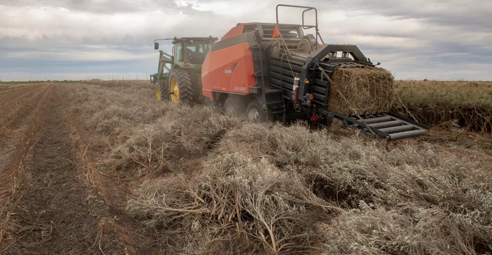
Paul Sanchez drives the custom guayule bailer from the Bridgestone Guayule Research Farm to harvest a field of guayule on a test field outside Stanfield, Arizona. The bailer is designed to cut through the woody stem of the guayule plant that would otherwise destroy a traditional bailer. Bill Hatcher
On a spring day that would have seemed abnormally hot anywhere else, I went rumbling down dirt roads south of Phoenix in search of an answer to a question that had been dogging me. The West is mired in a water crisis that’s difficult to fully comprehend. More than 40 million people in seven states and two countries depend on the Colorado River, and its waters are depleting at a terrifying rate. Since the 1900s, flows have decreased by 20 percent, a drop largely associated with climate change. Experts say the situation will only get worse.
For decades, leaders have sought a way to equitably share what’s left of the shrinking supply, but there has always been one stubborn sticking point: Farmers consume three-quarters of the region’s precious water, often to grow thirsty, inedible crops like cotton and hay. Many of them have been here for a century or more, and they aren’t about to leave. So, why can’t they grow something that sucks less water?
Outside Eloy, I drove past miles of empty fields riddled with Land for Sale signs. These farms had been hit hard by recent cutbacks in the delivery of Colorado River water, upon which they had relied since the 1980s. Those who were still in the game were scraping by and bracing for more rationing. Eventually, I came to a chain-link gate with a warning: “Watch out for snakes.” Behind it, I found a 300-acre desert laboratory operated by the Japanese-owned Bridgestone Corporation where a small team was toiling away, in some sense, on the same question.
The compound was nothing like the farms of fluffy cotton and bright green alfalfa I was used to seeing in central Arizona. A ring of barbed wire contained a stucco building with offices, meeting rooms, and a greenhouse where geneticists in white coats peered through microscopes. Out back, rows of ragged shrubs grew at varying heights. This was guayule (pronounced why-oo-lee), a plant native to Southwestern deserts that happens to produce latex. From this unassuming outpost, Bridgestone was trying to establish the country’s sole domestic source for the kind of high-grade natural rubber used in airplane tires and surgical gloves—and they were doing it with a crop accustomed to drought.
“This is a big investment,” said Dave Dierig, the farm’s trim and stoic manager, though he stopped short of naming a number.
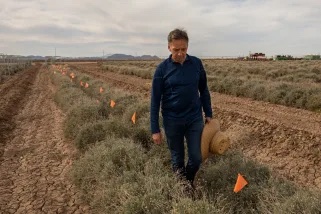
Dr. David Dierig walks along a row of guayule plants at the Bridgestone Guayule Research Farm. Bill Hatcher
The company intends to disrupt a supply line that has for more than a century been milking rubber from musty tropical forests and shift it to the middle of the searing desert. To succeed, this laboratory will have to develop a wundercrop that produces high rubber yields with relatively minuscule amounts of water. But that’s just the start. Bridgestone will also have to develop guayule-specific farm equipment and convince Arizona’s farmers—who cling proudly to their role in providing food and fiber for American families—to produce something that can be neither eaten nor worn. Many companies and the US government have already tried and failed.
“You can’t do it and make a buck. Good luck to the guy who says he can. But I think he’s dreaming,” Goodyear spokesman Hank Inman told the Los Angeles Times in 1988, the same year his company threw in the towel on its own guayule scheme.
And yet Dierig, who is also a plant breeder, was adamant that this time would be different. Bridgestone produced the first tires made entirely of guayule rubber back in 2015, and a couple years later received a $15 million grant from the USDA to continue its research. In 2021, the company announced an extension of those laboratory experiments, a breakthrough in its genetic research, and a commitment to opening a commercial processing facility in Arizona by 2026.
Squinting across a sea of teal shrubs, I thought: This is what adaptation to climate change looks like in Arizona. While coastal cities erect seawalls, river towns construct wetlands to absorb floods, and Californians thin their forests of tinder, desert farmers search for a crop that can survive 114-degree days on less than four inches of rain a year and still throw off enough cash to run their air conditioning.
And if this crop wasn’t it, well, then understanding exactly why might still help thousands of farmers—and the agriculture industry as a whole—carve a path toward sustainability in the desert.
Dierig bent over a guayule bush, tore off a woody stem, and showed me the dense hairs and waxy coating that keep moisture from escaping its leaflets. “There’s no other crop like guayule,” he explained. “It’s a true desert shrub” that just happens to produce latex. Beneath our feet, the densely planted shrubs sent their taproots 20 feet down toward moisture, a trick that allows them to survive prolonged periods without rain. Guayule needs about 3.5 acre feet of water each year (an acre foot is enough to cover one acre of land a foot deep), which is at least half a foot less than cotton and nearly two feet less than alfalfa. Dierig’s team is working to shave off another six inches while also increasing yield.
A thousand years ago, people indigenous to the Sonoran Desert chewed the shrub’s stems to release their latex and collected it in balls they might have played with. Archeologists found one of those at a dig just a few miles away. Considering that latex accounts for little more than 8 percent of the plant’s total biomass, it is astonishing that, within the hundred or so acres of guayule spread out before us, we were looking at enough rubber to make about 1,000 tires.
There are hundreds of plants that produce rubber, most likely as a defense against disease or parasites, but just a few that produce the kind of rubber needed to make tires and high-grade latex. Of those, guayule is the only plant adapted to arid environments. Today, about 90 percent of America’s natural rubber comes from hevea trees planted across some 27,000 square miles in Southeast Asia, accounting for three quarters of the world’s total production. This concentration exposes global stocks to disease and U.S. companies to market fluctuations. It’s not surprising, then, that Americans have been trying to drum up a domestic supply for some time.
In the 1920s a blight hit Brazil’s hevea tree plantations and the U.S. government started growing guayule, but it soon gave up the effort. In 1940, when Japan invaded Indochina and blocked access to that region’s hevea, the U.S. government planted about 30,000 acres of guayule, then burned 21 million pounds of it when the war ended and it became clear that tapping foreign stocks was far easier, in the short term, than establishing a domestic supply. Thirty years later, during the Arab oil embargo, the U.S. gave the shrub another abbreviated attempt in search of synthetic polymers. On each occasion, guayule projects were abandoned in favor of other more attractive crops or as soon as the price of imported rubber dropped. Sustainable production never took root.
Now, Bridgestone has made significant genetic breakthroughs and desert farmers are more desperate than ever for a way to stay in business. Might things be different this time around?
Rimjhim Aggarwal, a sustainability researcher at Arizona State University, told me that the region hasn’t taken alternatives seriously in the past. “Now that the water restrictions are here, I think we need to look deeper into other options,” she said. And in light of the food shortages seen in Phoenix during the pandemic, Aggarwal said it’s critical that agriculture doesn’t disappear from the central valley. Even if you can’t eat it, guayule is a high-value crop with a buyer in the wings, and it might provide a cash stream that keeps farmland in production.
In August of 2021, the U.S. Bureau of Reclamation announced the long-dreaded news: Cutbacks of Colorado River water were necessary to avert a larger catastrophe, and thanks to a byzantine web of 20th-century water laws, and a running list of court decisions and backdoor agreements, hundreds of farmers in central Arizona had drawn short straws. In 2023, this sliver of the state’s $23-billion agriculture industry would lose its entire allotment of river water.
The farmers knew this was coming. Those who haven’t sold out are fallowing (leaving unplanted) as much as 40 percent of their fields. Some have invested in drip irrigation systems, high-tech field moisture monitoring, and less-thirsty varieties of staple crops. Many more are, for the first time in decades, pumping groundwater—with limitations—from already stressed aquifers. And a few have even tried planting alternatives like barley and hemp. But so far, no new crop has lived up to its boosters’ hype, and most growers are sticking with what they know, as long as the water flows.
“There’s no point in growing something you can’t sell,” said Gary Deen, and he should know. From silver mining to cotton farming, Deen’s family has cashed in on some of rural Arizona’s most lucrative industries. I met him at the entrance to his 400-acre farm beneath a tree filled with so many warbling meadowlarks that I could hardly hear him recap the past hundred years of the state’s economic evolution.
Deen began growing Bridgestone’s guayule in 2015, but he hasn’t yet uprooted his wheat, cotton, or hay. The company planted 40 acres of its experimental crop on his land, managed the weeds, harvested the shrub, and paid him for the yield as if it were cotton. Bridgestone has been careful about setting farmer expectations too high, though.
Farmer Gary Deen walks a flooded irrigated field in Eloy, Arizona, where he once grew guayule that is being prepared for a cotton crop. Bill Hatcher
Past attempts put the cart before the horse, Dierig said. They gave experimental seeds to farmers prior to ensuring a long-term market. Now, working from seeds preserved at a national seed bank in Colorado and with two additional proprietary varieties, his team has mapped the DNA of different guayule strains to identify and select for traits like drought tolerance and the highest yield. Bridgestone also grows shrubs at satellite outposts to find varieties that can withstand frigid winters in upper elevations, since guayule takes two years to mature and the company intends to grow in Texas, California, and Mexico.
While Deen showed me around his farm, a custom-made prototype baler tore through a field of the stuff, which looked like an unruly weed beside his rows of orderly wheat. Guayule’s woody stems easily throttle conventional balers, so Bridgestone is also developing new harvesting equipment tailored to the shrub. Even the seeds, which are five times smaller than rice, needed a special wax coating to keep them from glomming together during planting.
Bridgestone has navigated these upfront hurdles because it sees so much potential on the back end, Dierig said at his laboratory. Domestic production will reduce the $1.4 billion a year that’s currently spent importing natural rubber to the U.S. But tires are just part of the picture. Bridgestone is building an ecosystem of markets, which includes the largest chemical company in Italy, to ensure farmers have plenty of reasons to grow lots of guayule.
Once completed, its new Arizona processing facility will be able to transform 1,000 tons of biomass daily into multiple high-value products, including latex for use in hypoallergenic surgical gloves (a $28-billion global industry), resin for use in adhesives, binders for asphalt, and terpenes for insecticides. Once these chemical compounds are separated, the remaining woody fibers, which account for about 80 percent of a shrub’s total mass, will end up as biofuel.
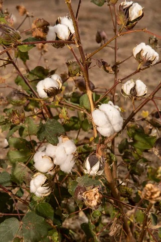
A cotton plant outside Eloy, Arizona a town in Southern Arizona that was almost renamed Cotton City in the early 1900’s. Bill Hatcher
For Deen, whose arrangement with Bridgestone ended after the company switched to using farmland closer to the desert lab, the best part of the deal was getting paid up front. That level of certainty is rare in a world where crop prices fluctuate and acts of God seem to be happening more often. Still, Bridgestone is scrambling to enlist enough growers.
“We’re paying a premium because we’re new,” Dierig said, but the company expects guayule to soon stand on its own—no premium, and no support for cultivation and harvest. To meet and sustain his commercial production goals, Dierig needs to have 10,000 acres in the ground by 2024 and another 10,000 acres the next year. There are only about 200 acres planted now.
“If we could find a crop that’s a low-water user, like guayule, that we can make money on, year in and year out, we’re going to be all over it,” said Dan Thelander, an elder statesman of Arizona agriculture whose family grows on about 5,000 acres in the central valley. They will plant around 40 acres for Bridgestone this spring.
Said Thelander, who has been involved in discussions of water shortages for years, “Everybody’s feeling the pain, but I can tell you that agriculture in Pinal County is gonna feel a lot more pain than anyone else.” As farmers fallow land, he explained, “there will be more laborers not getting paychecks; then they’re not buying things in stores—the fertilizer, the seed, the pesticide, the tractors, equipment, and repair.” A crop like guayule might lessen the strain on farmers and also buoy this weary community.
The Thelanders could handle 1,000 acres of guayule, but Dierig wants to keep initial production spread across many small parcels to hedge his bets against the region’s patchy rainfall patterns. That means winning buy-in from a small army of farmers accustomed, over the generations, to growing either cotton or hay, which they steadily sell to local dairies and ranchers, or to overseas customers who pay set rates for cheap grass.
Dierig and his team give presentations at Bridgestone’s farm to win new converts, and they’ve garnered a commitment from the Gila River Indian Community, whose tribal growers are entitled to more Colorado River water than any other central valley farmers. Cropping decisions are often determined by tradition, however, which puts guayule at a distinct disadvantage.
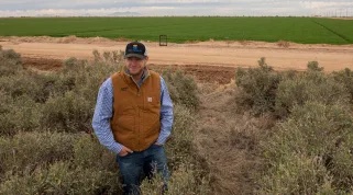
Farmer Will Thelander stands in a field of guayule south of Phoenix, Arizona. Bill Hatcher
When Eloy was established, in 1918, locals lobbied to name it “Cotton City.” A century later, the lucrative crop is still a winner: in 2019, farmers planted 85,500 acres of cotton in Pinal County, bringing in $92 million in revenue. Pinal ranks 10th among the nation’s cotton-growing counties. At his farm’s office, Deen proudly displayed a fibrous cotton tuft atop a hunk of silver ore. This cultural inclination presents an obstacle for Bridgestone, but so do the economics.
Tractors, fuel, seed, fertilizer, water—everything has grown more expensive lately, but land most of all. Thanks to Arizona’s fervent drive to build tract housing and strip malls, its average price of cropland, at $7,700 an acre, surpasses that of all Mountain West states (Idaho is a distant second at $4,450 an acre). And because most central Arizona farmers lease rather than own the land they grow on, many are hesitant to take risks that might delay their rent payments, especially with developers circling the perimeters, licking their chops. That said, as long as Bridgestone is paying cotton prices and guayule uses less water than cotton, farmers could grow more guayule than cotton on what water they have and make more money.
But it’s not that simple.
Pinal farmers also receive more federal funding than do farmers in any other Arizona county, and water-loving cotton is more heavily subsidized than any other crop in the state. Nationwide since the early 2000s, direct subsidies—paid at a set rate every year regardless of conditions—have largely been replaced by federally funded (and taxpayer supported) crop insurance payments, which compensate farmers if they experience a loss in crop yield or a decline in revenue. From 2000 to 2020, crop insurance paid to Pinal farmers rose from $3.2 million to $24.6 million, according to data collected by the Environmental Working Group. Three quarters of that money was paid to cotton growers to cover their losses, and half of those losses were caused by a “failure of irrigation supply.”
Might this government support nudge a farmer toward sticking with water-intensive cotton despite the extreme drought?
“Crop insurance is not intended to discourage or encourage the plantings of specific crops, but is simply there as a tool for growers of these crops,” explained Jeff Yasui, the USDA’s director of risk management for the Southwest. “The availability of the program does not consider water issues or the disbursement of subsidies.”
Leaves and dry flower stalks of guayule plants at the Bridgestone Guayule Research Farm in Eloy, Arizona. Bill Hatcher
In recent papers, however, agricultural economists have argued that the USDA’s crop insurance program disincentivizes experimentation with measures that might help farmers adapt to climate change. Even programs that encourage climate-smart tactics, like planting cover crops, can be less lucrative than insurance claims. Last year, Stanford University researchers reported that 14 percent of the $140 billion in crop insurance paid to farmers between 1991 and 2017 could be attributed to losses associated with temperature increases.
If the government is serious about helping desert farmers adapt to drought, it might invest as much in adaptation as it does in subsidizing the status quo. In the latest Farm Bill, the USDA provided support for some projects aimed at climate adaptation—like the $15 million Bridgestone received to help with research—and President Biden’s infrastructure bill earmarked more than $8 billion to update and augment water infrastructure in the West. But once Bridgestone stops paying its current premium, there will be little incentive for farmers who want to swap bags of cotton seeds for tiny grains of guayule.
I didn’t expect to find a silver bullet for the West’s water crisis at Bridgestone’s desert laboratory, and I didn’t. Clearly, guayule has enormous potential, otherwise the tire company, the US government, public universities, and so many others wouldn’t bother with it. It’s also true that Arizona’s farmers are heavily invested in crops that make little sense in a landscape facing megadrought. But decades of dam building, canal laying, deal striking, and subsidy paying have made the desert hospitable enough. And 300 days of sun make it a hell of a place to grow just about anything, anyway.
As one farmer explained after a long day of harvesting hay, “We have so many more costs here, but we can produce better yields per acre, and we can produce better quality because of our climate. If I was a supreme ruler of the world, there wouldn’t be anybody living in this goddamn state except farmers and ranchers.”
In the cities and suburbs, I’ve met many who would similarly like to have Arizona to themselves. For the time being, though, we all have to share it. And as long as that’s the case, we’d be better off designing a sustainable future together rather than holding our breath until the water runs out.
This article was supported by The Water Desk at the Center for Environmental Journalism, University of Colorado Boulder.
The Water Desk’s mission is to increase the volume, depth and power of journalism connected to Western water issues. We’re an initiative of the Center for Environmental Journalism at the University of Colorado Boulder. The Water Desk launched in April 2019 with support from the Walton Family Foundation. We maintain a strict editorial firewall between our funders and our journalism.
The Colorado General Assembly adjourned its 2022 session on May 11. Among the water bills that passed, four share a common theme—funding. A rare confluence of new revenue sources led to strong bipartisan support of bills dealing with groundwater compact compliance and sustainability, state water plan projects, wildfire mitigation and watershed restoration, and urban turf replacement. A bill designed to strengthen Colorado’s water speculation laws failed.
Groundwater compact compliance and sustainability
Senate Bill 28 creates a Groundwater Compact Compliance and Sustainability Fund to help pay for the purchase and retirement of wells and irrigated acreage in the Republican and Rio Grande basins in northeast and south-central Colorado. It appropriates into the fund $60 million in federal American Rescue Plan Act (ARPA) revenue that had been transferred into the state’s Economic Recovery and Relief Cash Fund. The Colorado Water Conservation Board (CWCB) will distribute the money based on recommendations from the Republican River Water Conservation District and the Rio Grande Water Conservation District, with approval by the state engineer. These are one-time dollars that must be obligated by the end of 2024; if not spent by then, they will be used to support the state water plan.
The bill seeks to reduce groundwater pumping connected to surface water flows in the Republican River to comply with a compact among Colorado, Kansas and Nebraska. It will also help meet aquifer sustainability standards required by state statute and rules in the Rio Grande Basin, home to the San Luis Valley. To achieve those goals, 25,000 acres of irrigated land must be retired in the Republican Basin, and 40,000 acres in the Rio Grande, by 2029. If the targets are not met, the state engineer may have no choice but to shut down wells without compensation.
Sen. Cleave Simpson, R-Alamosa, general manager of the Rio Grande Water Conservation District, noted that agricultural production coming out of the two basins benefits the overall state economy, not just the local communities. “The state has some skin in the game,” he said, and the availability of ARPA revenue “presented a once-in-a-lifetime opportunity” to support the districts.
Simpson emphasized that neither district is looking for a handout. The Republican has already assessed its water users over $140 million since 2004 to retire irrigated land and purchase or lease surface and groundwater to meet Colorado’s water delivery obligations. The Rio Grande district has taxed its farmers nearly $70 million since 2006 to take irrigated land out of production and has cut groundwater pumping by a third. Simpson requested $80 million from the Economic Recovery Task Force and, by demonstrating the interconnectivity between the state and local economies and the commitment already shown by the districts—along with strong bipartisan support from legislators—was able to secure the $60 million appropriation.
State water plan projects
Each year the Colorado General Assembly considers the CWCB’s “projects bill,” which, among other things, has included appropriations from CWCB’s Construction Fund to support grants for projects that help implement the state water plan in recent years. The funding source for those grants is different this year, with gambling revenue from Proposition DD, which the electorate passed in 2019, becoming available for the first time. Proposition DD legalized sports betting and levied a 10% tax on sports betting proceeds, with the majority of that revenue going into the Water Plan Implementation Cash Fund.
House Bill 1316 appropriates $8.2 million from the fund for grants to help implement the state water plan; $7.2 million of that amount is from sports betting revenue. Rep. Marc Catlin, R-Montrose, said, “This is the first appropriation of funds from Proposition DD … and it looks like it’s starting to grow into what we had hoped.”
The bill also appropriates $2 million to CWCB from its Construction Fund to help the Republican River Water Conservation District retire irrigated acreage. Rod Lenz, district president, said the district has doubled its water use fee on irrigators but that “we’re in need of short-term funding while we wait for that rate increase.” The $2 million in state revenue will help the district meet its 2024 interim target of retiring 10,000 acres of the 25,000 acres necessary to comply with the Republican River Compact by 2029. This is on top of the funds the district will receive from Senate Bill 28.
Wildfire mitigation and watershed restoration
Like Senate Bill 28, House Bill 1379 takes advantage of ARPA revenue by appropriating $20 million from the Economic Recovery and Relief Cash Fund for projects to restore, mitigate and protect watersheds from damage caused by wildfire-induced erosion and flooding. Testimony on the bill in the House Agriculture, Livestock & Water Committee emphasized how investing mitigation dollars now helps avoid spending even more on very expensive recovery efforts later.
The bill allocates $3 million to the Healthy Forests and Vibrant Communities Fund to help communities reduce wildfire risks by promoting watershed resilience. It moves $2 million into the Wildfire Mitigation Capacity Development Fund for wildfire mitigation and fuel reduction projects. And $15 million goes to CWCB to fund watershed restoration and flood mitigation projects, and to help local governments and other entities apply for federal grants under the Infrastructure Investment and Jobs Act related to water and natural resources management.
Turf replacement
While most of the focus at the Capitol in reducing water use has been on agriculture through retiring irrigated farmland, House Bill 1151 elevates urban turf replacement in importance. The bill requires CWCB to develop a statewide program to provide financial incentives for residential, commercial, institutional and industrial property owners to voluntarily replace non-native grasses with water-wise landscaping. It appropriates $2 million in general funds to a newly created Turf Replacement Fund and authorizes local governments, nonprofits and other entities to apply to CWCB for grants to help finance their programs. Landscape contractors, to whom individuals can apply for money to replace their lawns, are also eligible.
Rep. Catlin pointed out that “50% of the water that comes from the tap and goes through the meter and into the house is used outside.”
“We’re building ourselves a shortage,” he warned, “by continuing to use treated water for irrigation.” Rep. Dylan Roberts, D-Avon, added, “For too long the Western Slope and the Eastern Plains have borne the brunt of water conservation … but this is a bill that will give the tools to metro areas for them to play their fair part in this problem that is our drought.”
Investment water speculation
Senate Bill 29 was an attempt to strengthen protections against investment water speculation, defined as the purchase of agricultural water rights “with the intent, at the time of purchase, to profit from an increase in the water’s value in a subsequent transaction, such as the sale or lease of the water, or by receiving payment from another person for nonuse of all or a portion of the water.” It was aimed at curbing outside investors who may have little or no interest in agriculture from using the water right to maximize its value as the price of water increases during drought. It authorized the state engineer to investigate complaints of investment water speculation and, if found, to levy fines and prohibit the buyer from purchasing additional water rights for two years without the state engineer’s approval.
The 2021 interim Water Resources Review Committee recommended the bill, but it was never viewed as more than a “placeholder.” Sen. Kerry Donovan, D-Vail, a co-sponsor of the bill, expressed her disappointment that the bill did not generate more engagement between the water community and policymakers. “I was certainly hopeful that by having a bill we would force conversation,” she said, “but it did not result in having some forthright ‘let’s get around a table and hammer this out.’” Members struggled with trying to balance concerns over speculation with protecting property rights. Sen. Don Coram, R-Montrose, the other co-sponsor of the bill, emphasized, “We are certainly not trying to take a farmer’s or rancher’s ability away from selling that water. In many cases that is their 401K, their retirement.”
Opposition from water user groups in the Senate Agriculture & Natural Resources Committee sent a clear message: Existing legal requirements provide the necessary safeguards to address water speculation. Travis Smith, representing the Colorado Water Congress, said what’s needed is “having more voices, taking more time.”
Senate Bill 29 was amended to strike the language in the bill and refer the issue to interim study. Sen. Jerry Sonnenberg, R-Sterling, who was chairing the committee, expressed his frustration: “We have an ineffective water group that won’t have a conversation with lawmakers anymore. When they have a bill they just take a position and quit working with people.”
With that said he carried the bill over for further consideration, effectively killing it since this was the last committee meeting of the year. It’s unclear whether the issue will be studied this interim since it’s an election year and fewer committee meetings will be held.
Larry Morandi was formerly director of State Policy Research with the National Conference of State Legislatures in Denver, and is a frequent contributor to Fresh Water News. He can be reached at larrymorandi@comcast.net.
Fresh Water News is an independent, nonpartisan news initiative of Water Education Colorado. WEco is funded by multiple donors. Our editorial policy and donor list can be viewed at wateredco.org.
The Water Desk’s mission is to increase the volume, depth and power of journalism connected to Western water issues. We’re an initiative of the Center for Environmental Journalism at the University of Colorado Boulder. The Water Desk launched in April 2019 with support from the Walton Family Foundation. We maintain a strict editorial firewall between our funders and our journalism.
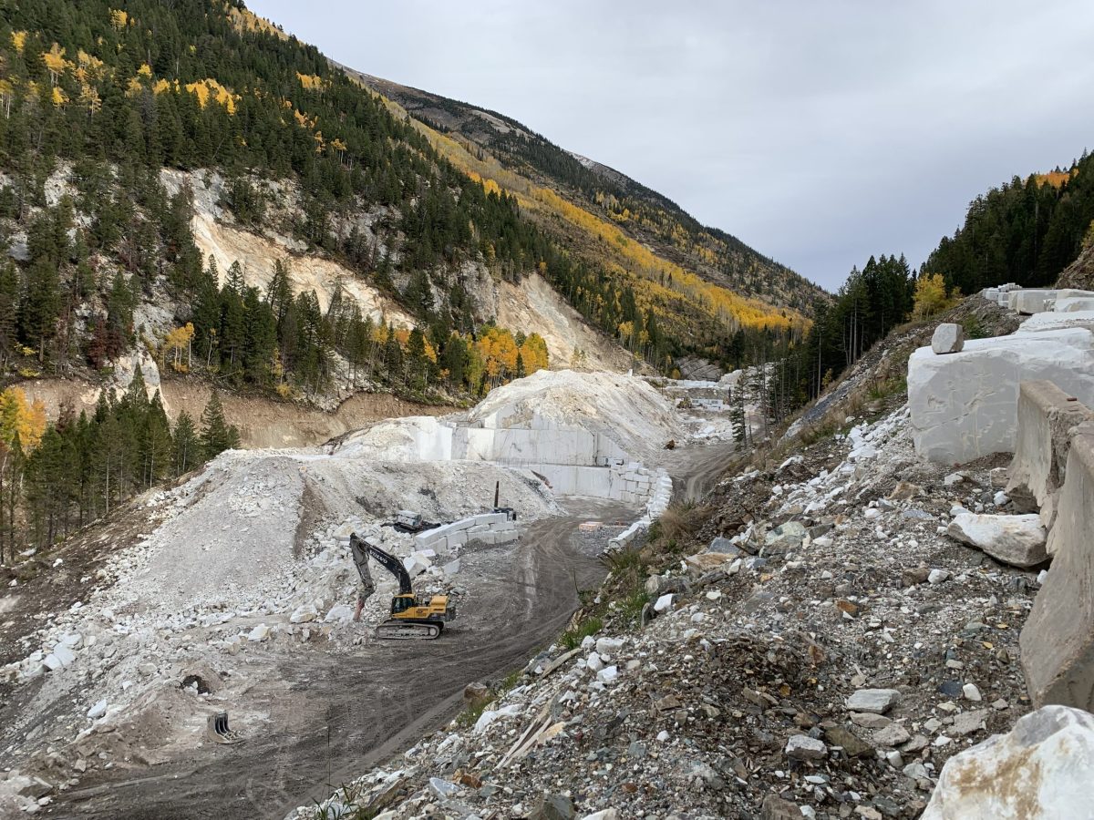
Part of the mining operations at the marble quarry as seen from a path above the quarry in September 2021. The quarry operators will have to comply with 10 special conditions as part of their permit from the U.S. Army Corps of Engineers. CREDIT: HEATHER SACKETT/ASPEN JOURNALISM
MARBLE —As a fix for violating the Clean Water Act in 2018, the operators of a local marble quarry must construct a culvert and bridge and rehabilitate the stream they illegally diverted, according to the U.S. Army Corps of Engineers.
Colorado Stone Quarries, which operates the Pride of America Mine perched 3 miles above the town of Marble on County Road 3C, diverted Yule Creek, a tributary of the Crystal River, into a new channel to make way for a mining road without first obtaining a permit from the U.S. Army Corps of Engineers.
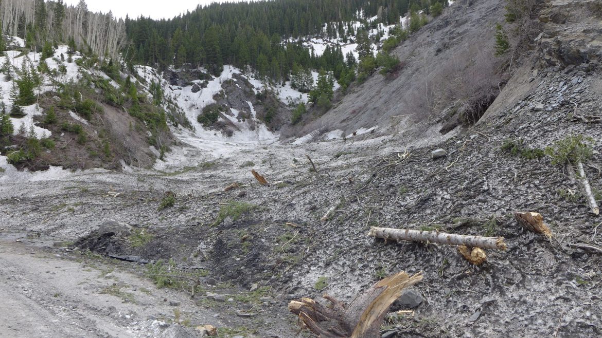
As compensatory mitigation required by the Army Corps, the mining company will have to improve and monitor for five years the affected stretch of Yule Creek. CSQ will also need to make major improvements to a culvert and a bridge where the Mud Gulch drainage intersects County Road 3C, about six-tenths of a mile downhill from the quarry.
These are two of 10 special conditions that the mining company must meet as part of its 404 individual permit issued by the Army Corps in February. The Mud Gulch work must be approved by Gunnison County and the U.S. Forest Service, and must be completed by February 2024.
Ben Wilson, project manager with the Army Corps, said the new 72-inch-diameter culvert and bridge will allow sediment to flow more easily under the road and down Mud Gulch, which is prone to mudslides. Mud Gulch intersects with Yule Creek downstream from the quarry and upstream of Yule Creek’s confluence with the Crystal River.
“They are reworking it almost completely to be a flow-through system that offers an ecological benefit of restoring that section of stream,” Wilson said. “It’s all about offsetting the ecological functional loss that was associated with the main project.”
The mining company said the Army Corps required them to choose compensatory mitigation that was “in-kind” to the impacts on Yule Creek and as close as possible to the affected area.
“Improvements to the Mud Gulch area will return the drainage back to its original flow path and provides a solution that is mutually beneficial to Gunnison County, the (Army Corps), the USFS and CSQ’s neighbors along County Road 3C,” CSQ General Manager Jean St. Onge said in an email. “These benefits will positively impact the wildlife and vegetative communities of the Yule Creek Valley.”
St. Onge said the construction work on Mud Gulch and Yule Creek stream restoration will begin in late summer or early fall.
In the fall of 2018, CSQ diverted about 1,700 linear feet of Yule Creek from its natural channel — located on the west side of Franklin Ridge, a rock outcropping — to the east side of the ridge. Operators used explosives to fill the original western channel with 97,000 cubic yards of material, including marble blocks.
Although this move probably spared Yule Creek the impacts of a diesel spill in October 2019, it was done without the proper permits or oversight, which the Army Corps determined violated the Clean Water Act.
Under Section 404 of the Clean Water Act, a project requires a permit from the Army Corps if it includes the discharge of dredged or fill materials into waters such as rivers, streams and wetlands. This is the permit that the Army Corps recently retroactively issued to CSQ, which contains the 10 special conditions.
Mud Gulch, which crosses County Road 3c about six-tenths of a mile from the quarry entrance, was still full of snow and branches in early May. CSQ will construct a new culvert and bridge to allow sediment to pass under the road as part of compensatory mitigation for violating the Clean Water Act. CREDIT: HEATHER SACKETT/ASPEN JOURNALISM
Yule Creek will remain in new channel
When the violation first came to the attention of the Army Corps, there was discussion about whether CSQ should return the stream to its original channel or leave it in the new eastern alignment. CSQ argued that it should remain in the new alignment, and the Army Corps agreed. Wilson said leaving Yule Creek in the eastern channel is what the agency calls the Least Environmentally Damaging Practicable Alternative, or LEDPA, which still allows CSQ to meet its project goals.
“We understand that leaving it in place is probably ecologically better now that it has already occurred,” he said.
CSQ will have to do ecological enhancement on the new stream channel by adding woody debris, creating pools and riffles, and planting willows, and then will have to monitor the channel for five years.
According to the other special conditions of the permit, CSQ also has to comply with state water-quality standards, post additional financial assurance to the tune of $235,430, submit annual reports to the Army Corps and implement an agreement with the State Historic Preservation Office, which includes adding interpretive signage in the form of bronze panels detailing the historic significance of the quarry.
To further compensate for the loss of aquatic resources, CSQ must establish a total of 11 acres of a preserved buffer along part of the creek where no further human disturbance can occur.
St. Onge said CSQ is committed to following each of the special conditions required by the Army Corps.
Environmentalists disappointed
Pitkin County and local environmentalists questioned whether the mitigation meets the requirements of the Clean Water Act and goes far enough to make up for the damage to Yule Creek. John Armstrong, president of the Crystal Valley Environmental Protection Association, said the conditions of the Army Corps permit are woefully inadequate in addressing the gravity of the situation.
“It just encourages the philosophy to ask forgiveness instead of permission to do things right in the first place,” Armstrong said. “It’s a real affront to the environmental community.”
He said the Mud Gulch area is a low priority for CVEPA and he would have liked to see mitigation occur at one of a number of sites downstream in the Crystal River Valley that need improving. In December 2020, CVEPA, along with Pitkin County and other groups, submitted comments to the Army Corps suggesting possible areas for restoration.
Kate Hudson, a resident of the Crystal River Valley and western U.S. coordinator for Waterkeeper Alliance, agreed. She said the requirements may not be enough to deter future violations or potential violators.
“I am very concerned that at the end of the day, what this company has been required to do by the Army Corps is not going to be sufficient to instill respect for our laws that are designed to protect our waterways.”
Pitkin County Attorney Laura Maker questioned whether the mitigation meets the requirements of the Clean Water Act.
“Whether or not (the Mud Gulch project) represents the best for the watershed, I don’t think that has been fully vetted,” she said.
The quarry site and Yule Creek are in Gunnison County, but the creek is a tributary of the Crystal River, which flows through Pitkin County.
The Pride of America Mine, known locally as the Yule Quarry, has been the source of marble for many well-known monuments, including the Lincoln Memorial, the Tomb of the Unknown Soldier and the Colorado Capitol. In 2016, the state Division of Reclamation, Mining and Safety granted the quarry a permit for a 114-acre expansion for a total of 124 permitted acres. CSQ officials say there is enough marble in its quarries to continue mining at the current rate for more than 100 years.
Aspen Journalism covers water and rivers in collaboration with The Aspen Times. This story ran in the May 14 edition of The Aspen Times.
The Water Desk’s mission is to increase the volume, depth and power of journalism connected to Western water issues. We’re an initiative of the Center for Environmental Journalism at the University of Colorado Boulder. The Water Desk launched in April 2019 with support from the Walton Family Foundation. We maintain a strict editorial firewall between our funders and our journalism.
Climate change, extractive industries and population growth threaten New Mexico’s water supplies, especially for indigenous communities. We talk to advocate Julia Bernal about potential solutions to these inequities.
Julia Bernal Julia Bernal is an expert and advocate on New Mexico water issues. Her work focuses on oil and gas development. She is an enrolled tribal member at Sandia Pueblo and is also from Taos Pueblo and the Yuchi-Creek Nations of Oklahoma. Starts at 1:05
If you’re interested in appearing on the show, please contact Water Desk Director Mitch Tobin at mitchtobin@colorado.edu. If you’d like to share your comments and questions, you can reach us at waterdesk@colorado.edu, or on Twitter and Facebook.
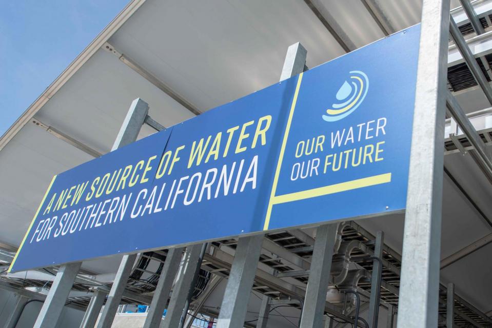
Metropolitan Water District’s advanced water treatment demonstration plant in Carson. (Source: Metropolitan Water District of Southern California)
By Nick Cahill
Momentum is building for a unique interstate deal that aims to transform wastewater from Southern California homes and business into relief for the stressed Colorado River. The collaborative effort to add resiliency to a river suffering from overuse, drought and climate change is being shaped across state lines by some of the West’s largest water agencies.
Southern California’s giant wholesaler, Metropolitan Water District, claims a multi-billion-dollar water recycling proposal will not only create a new local source for its 19 million customers, but allow it to share part of its Colorado River supply with other parched river partners already facing their own cutbacks. To advance what would become the nation’s largest wastewater recycling facility, Metropolitan is securing financial aid from other major Colorado River users in Nevada and Arizona in return for giving them portions of its river supply. Amid critically low reservoir levels and the first-ever shortage declaration on the Colorado River, water managers and experts are touting the interstate deal as a prime example of the team effort required to safeguard the future of this iconic Southwestern river and the people who rely on it.
“It’s a really interesting and innovative approach around partnerships,” said Heather Cooley, research director with the Pacific Institute, an Oakland-based water policy center. “Something we haven’t yet seen.”
Thus far the project appears long on support, but there are some potential impediments, such as whether the next set of river operating guidelines due in place by 2026 will allow the partners’ proposed long-term interstate water exchanges. Additionally, California regulators must clear the way for Metropolitan and others in the state to put the recycled supply directly into the drinking water system.
Aid for the struggling Colorado
Metropolitan pitched the ambitious wastewater recycling proposal more than a decade ago, but the project gained steam recently amid increasingly dry conditions across two of its key water sources in California’s Sierra Nevada and Colorado River Basin. Water interests along the lower Colorado River Basin have for several years discussed how they might augment the river’s shrinking flows. As it turned out, the Lower Basin’s next potential augmentation project is being hatched more than 200 miles away near the coast of California.
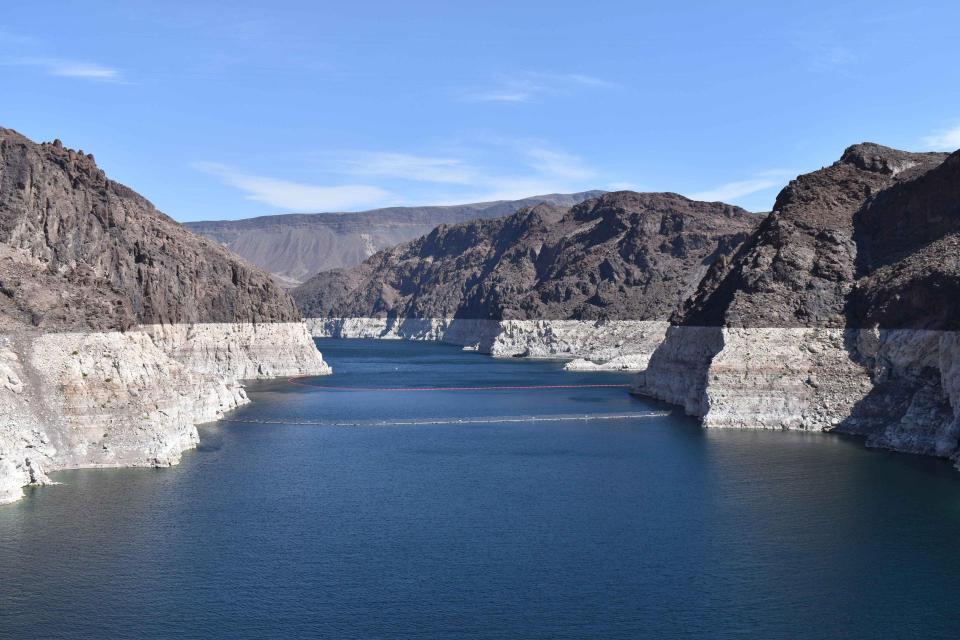
The mineralized white “bathtub ring” along Lake Mead’s edge shows the effects of more than two decades of drought along the Colorado River. (Source: Water Education Foundation)
Southern Nevada Water Authority, the Central Arizona Project and the Arizona Department of Water Resources have agreed to spend up to a combined $12 million to assist Metropolitan with environmental review, almost half of the total planning cost. If the project isn’t built, or if operating agreements aren’t finalized, Metropolitan would refund the agencies’ contributions. However, if the Nevada and Arizona agencies stay on to help build the final project, they will gain to-be-determined slices of Metropolitan’s annual share of Colorado River water.
The partnering agencies are currently grappling with major cuts to their own Colorado River supply, and more are on the horizon.
Last summer, the Bureau of Reclamation declared a first-ever shortage in the Lower Colorado Basin, requiring Arizona to slash its annual take of the river by 18 percent and Nevada by 7 percent in 2022. But the mandated cuts have done little to protect water levels at the river’s two main reservoirs, Lake Mead and Lake Powell, and now federal officials are on the verge of implementing a fresh round of unprecedented reductions that stand to affect supply for the Lower Basin states.
Metropolitan’s assistant general manager calls the deal a win-win for Southern California and the Southwest.
“The idea of the program is that in return for their co-investment to make this facility a reality, we would back off some of our Colorado supply,” Deven Upadhyay said. “It becomes one component of potential augmentation on the river to help others out.”
Boosting water security
At full capacity, Metropolitan’s wastewater recycling plant could produce up to 168,000 acre-feet a year. However, Upadhyay said Metropolitan doesn’t plan to make a corresponding amount of its river share available to the out-of-state investors.
But gaining even a sliver of Metropolitan’s Colorado River supply could boost water security for arid Arizona and Nevada.
“We’re at a point in this Basin where we can’t afford to not look at reasonable ideas,” said Colby Pellegrino, deputy general manager of resources for the Southern Nevada Water Authority.
Contract details haven’t been finalized but Pellegrino estimates SNWA could secure between 25,000-35,000 additional acre-feet annually, or around 10 percent of its yearly river apportionment. In Las Vegas, one acre-foot of water is enough to serve two households for more than a year, though officials are continually striving to reduce per capita water use.
Meanwhile SNWA, which relies heavily on Lake Mead to serve its more than 2 million customers in the fast-growing Las Vegas area, appears wholly interested in seeing the project through. It has already earmarked up to $750 million for Metropolitan’s proposal or other recycling projects. Such a major investment would require a long-term operating contract potentially in the 20- to 30-year range, Pellegrino said.
The partnership also figures to afford some long-term water security for Arizona, which takes the biggest hit of any state when shortages are declared on the Colorado River. Currently Arizona is grappling with how to cut 512,000 acre-feet and it faces further reductions if Lake Mead’s elevation drops below 1,045 feet and a Tier 2 shortage is triggered, a scenario the Bureau of Reclamation projects could happen by May 2023.
Gaining reliable access to Metropolitan’s river allotment could help Arizona address growing demand from municipal and industrial users, said Sarah Porter, director of the Kyl Center for Water Policy at Arizona State University. Porter applauded the multi-state collaboration, saying the recycling project and other augmentation ideas, like a proposed binational desalination plant along the Sea of Cortez in Mexico, could add flexibility to a system that serves 40 million people from Denver to San Diego and irrigates more than 4 million acres of farmland.
“It’s a huge amount of water,” Porter said of the potential yield of Metropolitan’s project for urban Southern California. “That’s one more community that relies on the Colorado River that has another degree of resilience.”
Water Treatment Plant would flow to various sites for use in replenishing groundwater or delivery to water treatment plants for distribution to ultimate users. (Source: Metropolitan Water District of Southern California)
A promising leap in reuse
California already has a rich legacy of turning wastewater into high-quality water suitable for a variety of uses including agricultural, groundwater recharge and outdoor irrigation. In 2020 the state used more than 700,000 acre-feet in recycled water, much of it going to golf courses, farms and some indirect potable uses. But experts say California can greatly expand the output through a recycling technology Metropolitan is currently ginning up support for.
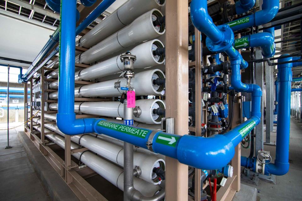
Deemed “direct potable reuse,” the method treats wastewater through a three-step purification process involving membrane bioreactors, reverse osmosis and ultraviolet light disinfection. Unlike conventional systems where treated wastewater is put into underground basins until needed such as how Orange County handles it, direct potable reuse supplies could go straight into the drinking water system.
Filtration pipes at Metropolitan Water District of Southern California’s wastewater recycling demonstration plant. (Source: Metropolitan Water District of Southern California)
Direct potable reuse, however, is not currently permitted in California, but the State Water Resources Control Board is expected to finalize regulations by December 2023. To prove to regulators and the public that the process is safe and viable, Metropolitan has been compiling water quality data from a demonstration facility in Carson since 2019.
The technology is a great match with a county like Los Angeles where most of the treated wastewater currently goes into the ocean, said Cooley, with the Pacific Institute. With imported water becoming increasingly unreliable, she said it was critical for Southern California to pursue new recycling projects, noting the region currently reuses only 29 percent of its effluent.
“There are lots of opportunities if we start thinking outside the box more and really look beyond individual agency service areas,” Cooley said. “We’re going to have to do more of that to address the challenges that we now face.”
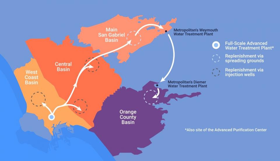
Once California gives the green light, Metropolitan says it will build a facility near the demonstration facility in Carson that could produce up to 150 million gallons a day of potable water or enough to serve more than 500,000 households, using wastewater from a nearby plant operated by the Los Angeles County Sanitation Districts. Purified water from the new recycling plant would be delivered to four of the region’s groundwater basins for later use and two of Metropolitan’s existing treatment plants via approximately 60 miles of new pipelines for further distribution in its service area.
Overcoming sticker shock
Neither construction nor the new water will be cheap.
In 2018 Metropolitan pegged construction costs at $3.4 billion, but inflation could spike the final price tag to $4 billion by the 2032 projected completion date. As for water prices, Metropolitan currently charges its member agencies around $1,100 per acre-foot of treated water; the new supply will likely run more than $1,800 per acre-foot.
Metropolitan Water District’s advanced water treatment demonstration plant in Carson. (Source: Metropolitan Water District of Southern California)
Upadhyay, the Metropolitan official, downplayed the difference by saying cost concerns are relatively minor compared to the damaging effects climate change is having on the Colorado River and Sierra Nevada watersheds it relies on for imported water. He added the agency is hoping to reduce the impact on member agencies with contributions from the out-of-state partners. In addition, it has asked the California Legislature to contribute $500 million. Metropolitan also is exploring the possibility of similar partnerships with users of California’s State Water Project, but no contracts have been signed, Upadhyay said.
“It’s not like we can go out and acquire more imported supply,” Upadhyay said. “Going forward, we really need to be looking here at home.”
That sentiment is shared among some agricultural interests in the basin, including Bart Fisher, vice president of the Palo Verde Irrigation District Board of Trustees. Fisher, who farms on the west side of the Colorado River near Blythe, Calif., called urban water recycling efforts the “wave of the future” and noted Palo Verde farmers have been utilizing water reuse techniques for decades.
“These urban projects have major implications for the Lower Basin,” he said. “It will alleviate some of the pressure we are feeling.”
Finding ways to work together
It’s unclear whether current operating guidelines for the river allow the sort of interstate exchange being proposed. But the partners say the concept shares ties with the intent of previously enacted conservation programs like the 2007 Intentionally Created Surplus, a water banking program intended to boost storage in Lake Mead. They hope guidance for interstate exchanges will be explicitly included in the next set of river operating guidelines that have to be finalized by 2026.
“It would behoove all of us to have a candid conversation in the renegotiations about that, make sure we have the rules spelled out,” said Pellegrino, SNWA deputy general manager.
Colby Pellegrino, deputy general manager, Southern Nevada Water Authority (Source: Southern Nevada Water Authority)
The 20-plus year megadrought is forcing all users in the Lower Basin to get creative in developing ways to stretch their shares of the Colorado River. And the clock is ticking.
Last month water levels at Lake Powell fell to a historic low and are still hovering near the minimum elevation level at which Glen Canyon Dam can generate electricity for more than 5 million homes and businesses across the West. The Bureau of Reclamation expects the combined storage at Lake Powell and Lake Mead to drop below 30 percent by late 2022 due to declining inflows of runoff.
Metropolitan’s wastewater recycling plant won’t cure all the Lower Basin’s myriad water troubles. But Colorado River veterans say the proposal is a welcome sign of progress, nonetheless.
“It’s good to see this multi-state collaboration and that’s what we do need,” said Porter, with Arizona State’s Kyl Center. “It’s better for everyone if we can find these ways to work together.”
Know someone else who wants to stay connected with water in the West? Encourage them to sign up for Western Water, and follow us on Facebook , Twitter, LinkedIn and Instagram.
The Water Desk’s mission is to increase the volume, depth and power of journalism connected to Western water issues. We’re an initiative of the Center for Environmental Journalism at the University of Colorado Boulder. The Water Desk launched in April 2019 with support from the Walton Family Foundation. We maintain a strict editorial firewall between our funders and our journalism.
Boaters float the Yampa River in northwest Colorado in May 2021. A recent report on stream management plans found that although they were set out to address flow needs for environmental and recreation purposes, only a small percentage have done that. CREDIT: HEATHER SACKETT/ASPEN JOURNALISM
Among the goals of Colorado’s 2015 Water Plan was to focus more attention on “non-consumptive” water uses — environmental and recreation water needs — through stream management planning.
The basic idea of a stream management plan, or SMP, according to the Colorado Water Conservation Board, is when stakeholders convene to evaluate the ecological conditions of their local river to identify flow needs to support environmental and recreational water uses.
The goal was to turn some attention on non-consumptive water needs and try to address the gap between how much water is in the stream and how much is needed for a healthy environment and a good recreational experience.
“The environment and recreation are too critical to Colorado’s brand not to have robust objectives; a strong Colorado environment is critical to the economy and way of life,” reads the Water Plan, referring to the need for SMPs. The Water Plan’s objective was to cover 80% of locally prioritized rivers with an SMP by 2030.
But according to a recent River Network report on the 26 SMPs completed or in progress statewide as of September 2021, in some cases the process seems to have been taken over by agricultural interests, watering down what was supposed to have been a tool specifically for the benefit of non-consumptive water uses.
“A pillar of CWCB’s grant guidance for stream management planning is to ‘identify flows needed to support environmental and recreational water uses,’” the report reads. “This pursuit — as a primary SMP focus — has not been consistent and has proven problematic and even unpopular among participating stakeholders.”
Most SMPs evaluate flow regimes, but don’t make recommendations for a specific target flow. Of all the 269 project recommendations, just 6% focused on environmental flow targets and only 1% focused on recreation flow targets. In contrast, 14% of recommendations involved agriculture diversion reconstructions, the largest percentage of recommendations.
And although there are many recommendations for projects like stream restoration (11%) and recreation enhancements (7%), putting a number on how much water a stream needs for environmental or recreation purposes is rare. Projects tend to focus on physical modifications to the stream channel and not necessarily how to get more water into that stream channel.
“This was something I was afraid was going to happen,” said Ken Neubecker, retired Colorado projects director for American Rivers and former Colorado Basin Roundtable member. “I am a little disappointed. Yes, you’ve got to have the other stakeholders engaged, but the original intent with stream management planning was that it should primarily be addressing the environment and recreation needs of a certain stream reach.”
This Parshall flume measuring device is being installed on a ditch on Morrisania Mesa. Ditch inventories, funded in part with state grant money, are becoming popular aspects of stream management plans. CREDIT: HEATHER SACKETT/ASPEN JOURNALISM
Bringing ag to the table
Nicole Seltzer is the Colorado River basin program director with River Network, the organization that produced the report and which works to protect and restore rivers. She said there are multiple factors as to why more environmental flow recommendations haven’t yet come out of the SMP process, including a lack of stream gauge data on some tributaries. But a main reason is because it’s a sensitive topic that has to be navigated carefully.
“Sometimes you have to let go of the conversations that are super divisive in order to keep your group together and keep making progress on other things,” Seltzer said. “I think that we’ve seen that the conversation around environmental flow goals and how you meet those goals is sensitive and it has the ability sometimes to derail the entire process.”
That divisiveness reveals the tension between traditional water users like agricultural producers, who take water out of the rivers, and recreational and environmental water advocates, whose goal is to keep water in the river. Environmental and recreation groups have historically not played as big a role in water planning as agricultural and municipal water managers. The SMP process was supposed to be a way to legitimize and enhance their role.
But because agriculture controls the oldest water rights and makes up the largest slice of water use in Colorado — 86% according to numbers provided by the state — some SMP stakeholder groups realized they couldn’t make progress without including agriculture representatives.
“Our organization very quickly realized if you’re going to get anywhere environmentally, you don’t just want to operate in a vacuum,” said Richard Van Gytenbeek, Colorado River basin outreach coordinator for environmental group Trout Unlimited, and a Colorado Basin Roundtable member. “You’ve got to bring your municipal and agriculture folks to the table.”
In some cases, what started out as an SMP morphed into an IWMP — Integrated Water Management Plans — so named because they integrate the “non-consumptive” environmental and recreation water uses and the “consumptive” agricultural uses.
The Colorado Basin Roundtable adopted the term IWMP in place of SMP in 2016 and defined the primary goal of an IWMP as “identifying opportunities to meet environmental flow needs along with needs of agriculture, municipal, industrial and residential water users.” The roundtable’s choice to use the term IWMP was in response to concerns that stream management planning could emphasize environmental and recreational water needs in a way that might negatively impact agricultural water users and other interests.
The IWMP undertaken by the Middle Colorado Watershed Council was one of these that started out as an SMP and then expanded the scope to incorporate agricultural interests. The Book Cliff, South Side and Mount Sopris conservation districts tackled the agriculture portion, which included an agricultural water use analysis and inventories of 59 ditches. The individual results of the ditch inventories were not made publicly available, despite being publicly funded.
The final action plan outlines 55 recommendations, including six which it says address protection of flows. These include doing a survey of boaters and anglers to see what their flow preferences are, installing more stream gauges on local tributaries of the Colorado River and supporting the Colorado River District as they work to keep water on the Western Slope.
The idea was that a watershed council, environmental group or other organization would come up with a way to prioritize local streams and get to work creating SMPs for 80% of the ones they deem to be high priority. But since there was no standardized way to do this across the state, streams in areas with environmentally focused watershed organizations tend to have SMPs, while those without them don’t.
Multi-benefit projects
Many of the projects recommended in the SMPs are “multi-beneficial,” meaning they benefit multiple water user groups: agriculture, environment, recreation, municipal, industrial. Checking more category boxes for a project can sometimes aid in getting grant funding.
Often, the thinking around a diversion reconstruction or other improvements to irrigation infrastructure is that it can help irrigators more effectively get water out of the river. At the same time, a project could also create a safer passage for boaters or better fish habitat. But these multi-beneficial projects can also have a downside.
“There is an argument that focusing on multibenefit projects that primarily benefit water users dilutes environmental and recreational flow objectives,” the River Network report reads.
And the tools for boosting river flows are few. While some SMPs are motivated by needing to meet federal requirements, for example keeping enough water in the chronically dry 15-mile reach of the Colorado River in the Grand Valley for the benefit of endangered fish, this is not common, according to the report.
“In most communities, the only options for pursuing flow-driven outcomes are expensive infrastructure (e.g. ditch piping) or tools for leaving excess water in the river (e.g. water leasing),” the report reads.
The idea is that when irrigators have more efficient diversions, they don’t need to take as much water from the river, leaving more for the benefit of the environment and recreation. But whether that actually happens or not is unclear.
CWCB Watershed Protection Director Chris Sturm said that addressing flow needs is not the only metric of success for an SMP or a project. If a project results in any kind of physical benefit to the stream, it can be considered a win. He said by and large the SMPs are accomplishing what they set out to do.
“Stream management planning is not all about identifying what the flow needs are,” Sturm said. “I think what our stakeholders are doing is they are finding a path towards trusting each other enough to get to those discussions about flow needs. And it’s being done in a way where they are partnering on projects like diversion reconstructions, which is why you see so many of them.”
Although low flow is not the only issue for the environment and recreation communities, it is often the biggest; other problems like high water temperatures are partly a result of there not being enough water in the river.
“I would say recreation in Colorado is more threatened by diminishing streamflow,” said Hattie Johnson, southern Rockies stewardship director with American Whitewater. “You can fix the navigation hazard, but if there’s no water in the river to float down it, it doesn’t matter. I think the flow aspect of it is much more dire.”
Raymond Langstaff, president of the Book Cliff Conservation District, speaks at a River District meeting in May 2022. Langstaff participated in creating the IWMP for the Middle Colorado because, he said, “ag has a target on their back for water.” CREDIT: HEATHER SACKETT/ASPEN JOURNALISM
Agriculture has the bulk of the water
Raymond Langstaff is the president of the Bookcliff Conservation District, which extends roughly between Glenwood Springs and Parachute, mostly on the north side of Interstate 70. His organization, along with the Mount Sopris and South Side conservation districts, led the agriculture portion of the IWMP process for the Middle Colorado region.
“One of the reasons we got involved is because we have a target on our back for water,” Langstaff said. “The bottom line is ag has the bulk of the water. When people need water, where are they going to go? They are going to go to ag to get the water.”
And agricultural water users are feeling the squeeze from drought and climate change too. Langstaff, a retired engineer with the U.S. Forest Service, has a place on Dry Rifle Creek that has been in his family since 1951. He irrigates about 22 acres of grass and alfalfa with water from the Grass Valley Canal and sells the bales of hay to horse owners.
This year, the number of days he is allowed to use water from the local irrigation water project dropped from 50 to 35 this year. If the water gets cut more, he may do one fewer cutting of hay. And irrigators on the south side of the Colorado River have it even worse.
“If you live on Divide Creek, chances are you will be out of water somewhere around the Fourth of July,” he said.
One of the ideas behind the ditch inventory, in which irrigators got an analysis of their system and potential areas of improvement, was that they would result in efficiency projects that would benefit the irrigator and could also leave more water in streams for the benefit of the environment.
But Langstaff is skeptical that agriculture projects will automatically lead to more water in streams. If agricultural producers can more easily get access to their full water right by making efficiency improvements, they will probably take advantage of that by using all of their water, he said.
“It’s a false hope they might be able to free up a little more water to leave in the river,” Langstaff said. “If you get more efficient, you get to water more times. And it’s their water and they have the right to use it.”
The results of a 2019 survey about SMPs by the Colorado Cattlemen’s Ag Water Network seems to confirm that sentiment. More than half of respondents said the amount of water available to them was a challenge. Survey responses also indicated that more acres would be irrigated and more acres would be more fully irrigated if more water was available for diversion.
If environmental and recreation groups want more water to stay in the river, it will require paying agricultural water users, Langstaff said.
“If you want ag to let water stay in the stream, you’re going to have to compensate somehow,” he said. “If you’re in the ag business exclusively, you need every nickel and dime.”
Boaters on the Yampa River in May 2021. Stream management plans were originally intended to address flow needs for recreation and environmental water uses, but traditional water uses like agriculture often participate in the process too. CREDIT: HEATHER SACKETT/ASPEN JOURNALISM
A way forward
The actions of diverters often have the biggest influence on the health of rivers and the quantity of water in them. And as the flows of the Colorado River and its tributaries continue to decline due to climate change, there will be even less water to go around.
In the hierarchy of water uses in Colorado, environmental and recreation interests have taken a back seat to traditional water uses like agriculture. Under the bedrock principle of Colorado water law, prior appropriation, the oldest water rights — typically agricultural water rights — get first use of the river.
The only way to secure a water right specifically for the environment is through an instream flow right, which is held exclusively by the CWCB to “preserve the natural environment to a reasonable degree.” Although the state has ISF rights on nearly 1,700 stream segments around Colorado, they date to the 1970s and later, making them very junior to most agricultural and municipal water rights, and thus limiting their ability to keep water in the stream.
As for recreation, a handful of communities around the state hold what’s known as a recreational in-channel diversion, or RICD, around which they have built a whitewater park or play waves primarily for kayakers. But in a nod to traditional water users, these rights often end up making concessions to future water development. Two bills floated by recreation proponents that aimed to secure water for recreation purposes have stalled in 2021 and 2022.
But most environmental and recreation groups still say that cooperation among all water users within the existing constraints is the best way forward and insist they are making inroads.
“If you’re an environmental advocate you do the best operating in the system that exists, and the system that exists is Colorado water law,” Van Gytenbeek said. “You have to work with water rights holders to see if there’s flexibility in their operations. It’s not a perfect world and it can be very frustrating if you are a kayaker or a fisherman. But we are making progress by collaborating.”
The Water Desk’s mission is to increase the volume, depth and power of journalism connected to Western water issues. We’re an initiative of the Center for Environmental Journalism at the University of Colorado Boulder. The Water Desk launched in April 2019 with support from the Walton Family Foundation. We maintain a strict editorial firewall between our funders and our journalism.
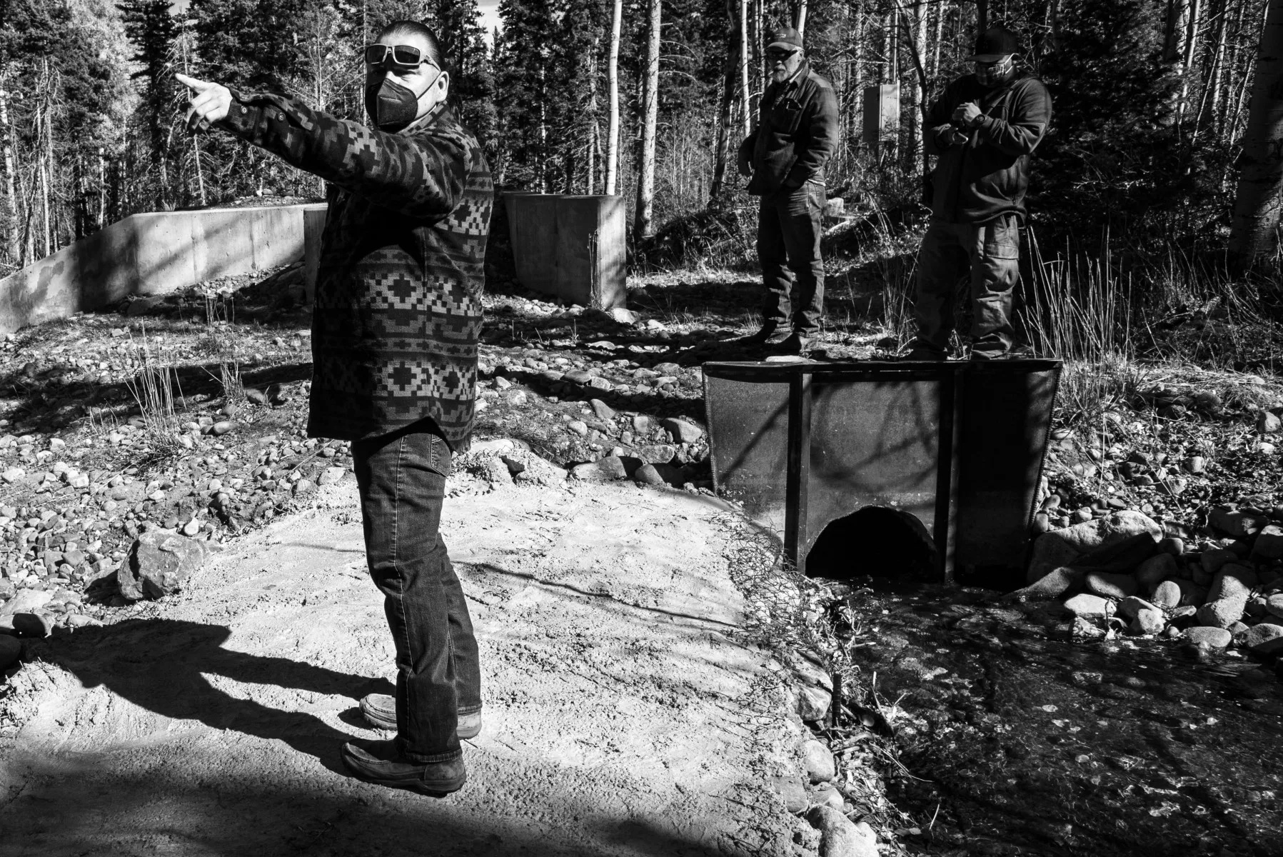
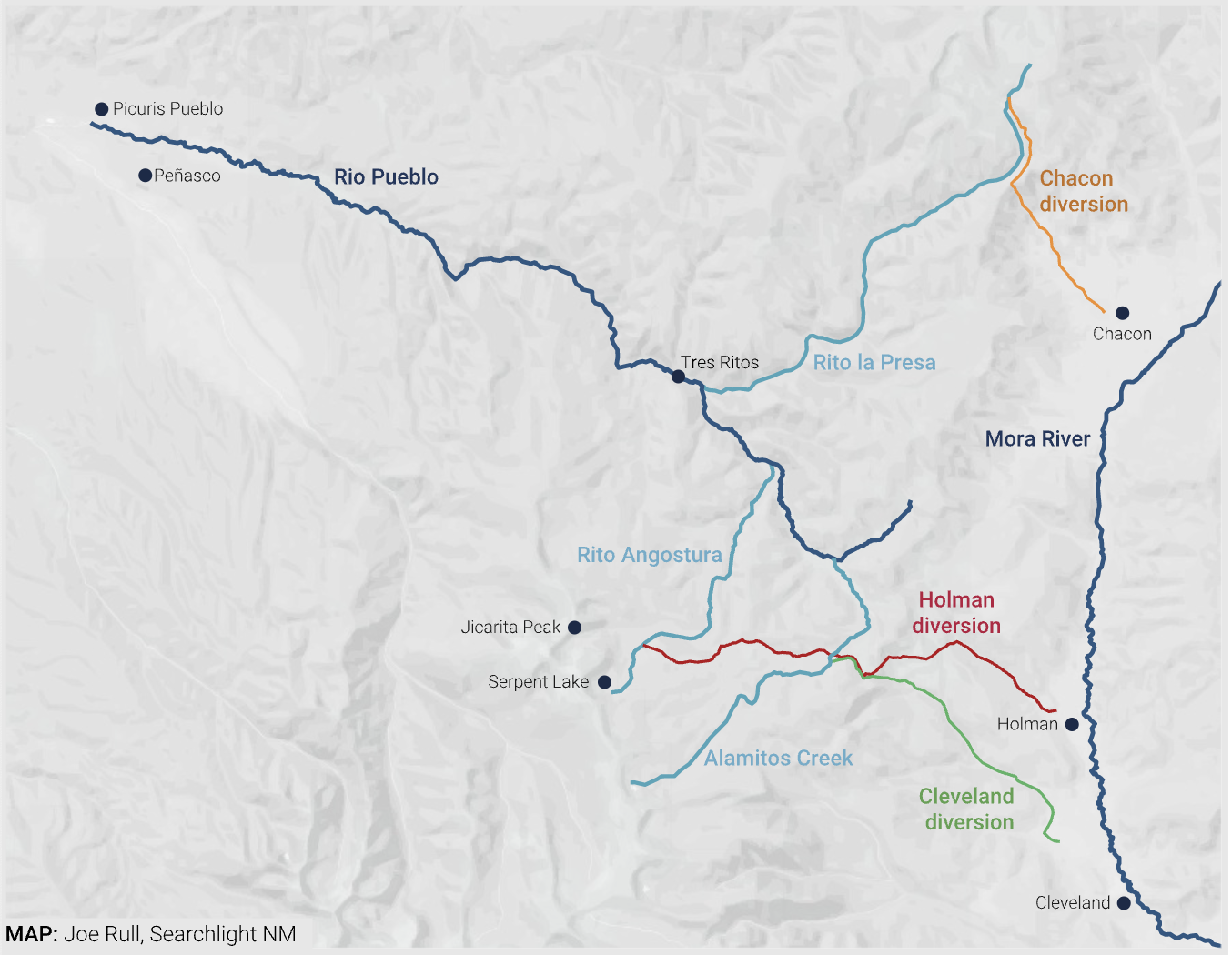
On a sunny day in late October, a handful of people from Picuris Pueblo drove to Carson National Forest and parked their vehicles off a dirt road that reaches into the Sangre de Cristo Mountains. They walked east for a few minutes, to Alamitos Creek, some 16 miles from the pueblo’s boundary. Among them was the pueblo’s governor, Craig Quanchello, who led the way through a grove of conifers and aspens on the eastern slope of Jicarita Peak. Though Quanchello and his companions, including other members of the tribal administration, had heard rumors about what they had come to see, they were not entirely prepared for it.
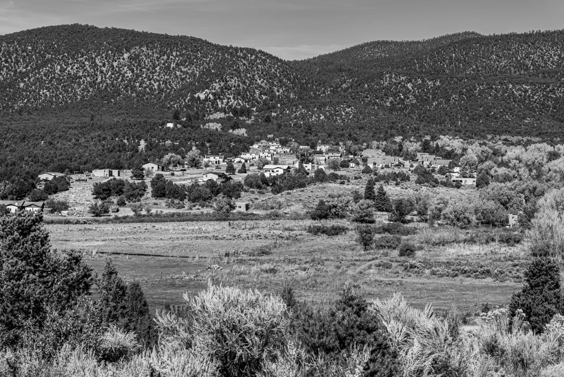
If nature had its way, Alamitos Creek would merge with the Rio Pueblo, which flows through Picuris Pueblo. But a diversion on the stream at 9,800 feet above sea level shunts its water into a ditch and over a mountain pass instead. The creek drops into the Mora Valley near the town of Cleveland, where livestock graze in scenic pastures, huge piles of firewood are heaped beside homes, and an abundance of old adobe architecture creates the sense of a place strongly connected to its past. The water from the Alamitos is absorbed by fields and gardens there.
Picuris Pueblo
Over the past 12 or so years, irrigators in Cleveland have transformed the diversion from a set of leaky wooden boards to a wall of stacked sandbags to an embankment of large rocks. At the end of September, a month before the team from Picuris visited, the berm had been plastered over with cement. There was no opening, not even a headgate, in the direction of the Rio Pueblo. While water from the Alamitos coursed down the ditch toward Cleveland, the creek bed that runs to the river was dry.
Seeing the cement work for the first time, a palpable swell of outrage arose within the group. It was one more insult to the tribe, one further violation of their sacred lands, one more unilateral move by irrigators to assert permanent control over water that the pueblo leadership claims has been stolen from them for the past 200 years.
A headgate in Cleveland splits water carried from Alamitos Creek between the Encinal and Cañoncito acequias.
“It’s time to take it into our own hands,” Quanchello said, meaning destroy the diversion with heavy machinery and redirect the Alamitos back into its natural channel. “If Mora wants to fight, so be it.
“It’s going to get dirty,” he added soberly. “Someone’s going to get hurt.”
A few weeks later, on or just before Nov. 13, the cemented berm was smashed open. A hundred or so yards away, a huge mound of dirt and rocks had been piled in front of the headgate for a different diversion, one that sends water to the community of Holman, also in the Mora Valley. No one has claimed responsibility for the potentially illegal act of vandalism. “Everyone knows who has motive,” said John Romero, water rights division director at the Office of the State Engineer (OSE), which manages New Mexico’s waters. “But I’m not going to speculate.”
The steep divide
There are three diversions that take water away from the Rio Pueblo watershed and deliver it to the Mora Valley. All of them pre-date New Mexico statehood, as does Picuris Pueblo’s opposition to them. The one on the Alamitos feeds two acequias, or irrigation ditches, in Cleveland, and was built sometime around 1820 — three decades before the area was ceded by Mexico to the United States. The second diversion, created in 1865, moves water from the Rito la Presa, over a steep divide and into two acequias in the tiny hamlet of Chacon. The third, which became operational in 1882, captures the Rito Angostura and sends it to Holman. Together, they irrigate some 1,900 acres in the agricultural-rich Mora Valley, serving 143 users, or parciantes.
Picuris wants to see all three diversions dismantled and the streams returned to their natural courses. This could bring substantially higher flows to the pueblo, where about 250 of some 385 tribal members live on the same land that their ancestors have called home for the past millennium. Doing so, however, could critically impact the residents in the Mora Valley who have relied on these waters for generations, today primarily to grow hay.
“Without this supplemental water, we wouldn’t make it,” said 79-year-old Eufracio Vigil, whose family has been in Chacon for five generations and who has personally helped maintain the local acequias since the 1950s.
Eufracio Vigil of Chacon is secretary treasurer of Acequia del Rito y la Sierra. “We only get water from May or maybe June, and it’s done by the end of July. …If Picuris is hurting, it doesn’t mean we’re taking their water – it means we’re hurting too. Without this supplemental water, we wouldn’t make it.”
While the dispute over the diversions is emblematic of simmering water conflicts across the drought-stricken American West — as well as broader conversations about righting historical wrongs against Indigenous peoples — it is also uniquely New Mexican. Complex and vague water laws regarding pueblos, acequias and natural streams make the prospect of pursuing a legal settlement monumentally daunting for all sides. The possibility of reaching a sharing agreement, in which Mora would receive less water but Picuris wouldn’t get it all, has been rejected by the pueblo and some of the irrigators.
‘El agua es vida’
In the high desert valleys of New Mexico, the saying “el agua es vida” — water is life — is a self-apparent truism. Where water flows, things grow, creating green ribbons that trace the outlines of rivers and streams. These fertile floodplains are often framed by dry, rocky hills and mesas speckled with hardy piñon trees, juniper and cacti.
Holman, in the Mora Valley
Beginning in the late 16th century, Spanish colonists created a system of gravity-fed acequias in New Mexico to grow food and fodder. About 700 acequias currently operate in the state, according to the New Mexico Acequia Association. In many communities, they are seen as crucial not only to the survival of fields and orchards, but also to centuries-old local traditions — to the very soul of a place. The annual spring limpia (ditch cleaning); the opening of headgates; the dialogues about water-sharing arrangements in times of drought; the sight of water flowing like capillaries through towns, around farm plots — or in the case of Las Trampas, down a flume carved from tree trunks — are all part of what makes New Mexico New Mexico, especially in its small villages.
Typically, each acequia operates within a single watershed: water is channeled from a river to fields that lie alongside it. All of the water remains within the same hydrological system. But the three diversions at the heart of the dispute between Picuris and irrigators in the Mora Valley are different. The irrigators take water that belongs to the Rio Pueblo — which is part of the Rio Grande Basin — and move it to the Mora River, in the Arkansas River Basin. This strikes Picuris as ecologically and spiritually criminal.
“They’re killing the land, killing the environment,” Quanchello said at Alamitos Creek. He made a sweeping gesture to indicate the entirety of the landscape: “This is our homeland. It’s all significant to us,” he said. “Our herbs and traditional medicines and spiritual plants are being depleted because they need water. You can’t just replace this stuff.”
“Water is vital from a spiritual perspective,” said Picuris Tribal Interpreter Cecilia Shields, one of the group at the creek with Quanchello. “And these waters, which flow from around Serpent Lake, are particularly sacred. It’s a place of prayer, a place where our people pilgrimage, our center place,” she explained. “The whole of Jicarita Peak and what the mountain holds are all sacred, and to remove things from it” — as the diversions do — “is to cut off the balance. The people of Mora taking the water, it’s a desecration. It’s heartbreaking.
“We have no issues with anyone on our same watershed,” Shields added. “Of course we’ll share with them, but not with users taking the water where it wouldn’t naturally go.”
Picuris Pueblo Tribal Interpreter Cecilia Shields looks at the dry Alamitos Creek bed, just below the diversion to Cleveland. “We’re still subject to colonial systems, like the Forest Service and the acequia associations, but we are the sovereign nation,” she said. “We’re trying to work with the state on a government-to-government level, but nothing happens. We’ve been dealing with this for years, and it has to stop. Now we know how to read their language, to use litigation, we have heavy machinery — we’re not just weak little Indians.”
Long battles, harsh betrayals
Picuris first lodged protests against the diversions to Cleveland and Chacon as early as the late 1860s. They were summarily ignored. When the Holman ditch became operational in 1882, the pueblo, with the help of Indian Agent Benjamin Thomas, promptly pursued a lawsuit in district court.
In a betrayal that stings to this day, the attorney assigned by the Department of Justice to represent Picuris in the suit simply never showed up in court. This was a “disaster” for Picuris, Malcolm Ebright — a lawyer who has worked with pueblos and acequias — wrote in a 2017 article for the New Mexico Historical Review. Unable to find anyone willing to take their case, it was ultimately dismissed in 1885.
Records from the lawsuit contribute both clarity and confusion to the history of the diversions. While filings in the case clearly stated Picuris’ objections to all three ditches and the harm they were causing the pueblo, the remedy they sought specifically requested an injunction only against the one to Holman. Additionally, the Indian agent wrote that Antonio Olguín, who founded the community of Cleveland, “was allowed [by Picuris] to take this water” when he masterminded the first diversion. Irrigators in Cleveland today take those words as proof that they did not steal the water. It is a position with which Ebright, a noted author of books on pueblo history, tends to agree. “There doesn’t appear to have been any protest against it at the time of construction,” he said in an interview.
Serpent Lake, elevation 11,750 feet, is sacred to Picuris Pueblo, as are the springs below it, which feed Alamitos Creek and Rito Angostura. “This is our Blue Lake,” Quanchello said, referring to the lake sacred to Taos Pueblo, which was returned to the tribe in 1970 by an act of Congress.
Picuris flatly rejects this conclusion, pointing out that there is nothing in the historical record that corroborates Thomas’ statement. “There is no documentation showing that we gave them any water,” Quanchello said. “And even if so, we would never have given them permission to take an entire stream! Our elders tell us that their elders had told them that our people have always wanted the water back.”
‘Difficult to convince non-Indians’
There are no simple paths forward for Picuris. Pressing their claims in court today would require filing for an adjudication to determine how much water they are legally entitled to. It’s a process that can cost millions of dollars and take decades to resolve. “Most adjudication cases outlive the judges and lawyers on them,” said Richard Hughes, a lawyer and water-rights expert who has represented several pueblos. He is currently working on cases that were first filed in the 1960s.
“Complicated cases like this one require lots of expert work — from the historical to the hydrological. It gets very expensive,” Hughes said. But, he noted, voluntary water-sharing agreements aren’t easily reached, either. “If you don’t have legal proceedings ongoing, it’s difficult to convince non-Indians that you have any leverage against them. It’s difficult to convince people who have been using this water for over a century to give up some of what they have.”
Official statistics that accurately convey just how much water is being diverted from the Rio Pueblo to the Mora River don’t exist. One former president of the Embudo Valley Regional Acequia Association, however, has pored over the available data, comparing flows on the Rio Pueblo with flows into the diversions. “Fifteen to 20 percent of all the water that should be going into the Rio Pueblo is going to Mora,” Robert Templeton concluded. But the reality is worse than those numbers imply: “In drought years, over 50 percent of the water goes to Mora during the peak irrigating season of June and July — and climate change means more drought years.” He estimates that “more than half a million acre-feet of water” has been diverted over the years — which could fill a lake the size of the Santa Fe Plaza to a depth of 94 miles.
Templeton’s assessment is not without its critics. Among them is Romero of the OSE. “Robert Templeton interpreted the flow data incorrectly,” Romero said in an interview, though he couldn’t point to any specific errors in Templeton’s calculations.
What matters, Romero said, is not what percentage of the Rio Pueblo’s natural flow is being diverted, but how much water Picuris is actually receiving, and whether that’s sufficient to meet the pueblo’s needs. To create a fair solution, “You have to look at the whole system,” which would include all of the water in all the tributaries feeding the river, he said. “We need more streamflow data over a longer period of time. We’re trying to find out how much boost the [diverted] streams would provide if added to the Rio Pueblo. Right now, I really have no idea.”
Paula Garcia, executive director of the New Mexico Acequia Association, asked, “How do we, as Chicanos, as New Mexicans, make this right for Indigenous people? We see ourselves as victims of Manifest Destiny, but there’s another layer of oppression that pueblos had to survive that we should be mindful of. …Can we have more compassion?”
First come, first served
When there’s not enough water to go around, rights to it are allocated on a first come, first served basis: Whoever has been using it the longest has a stronger claim than those who began using it later. In times of drought, the “senior” can make a priority call, and the “juniors” may then have to cut their usual allotment.
Paula Garcia, executive director of the New Mexico Acequia Association, whose family has lived in the Mora Valley since the 1860s, put it bluntly: “There is no debate. Picuris has senior water rights. They’ve been here since time immemorial.” As Garcia sees it, “The people on the acequias don’t understand water law — that you can’t fight with the pueblos the way you can fight with other acequias.”
Antonio Medina, 83, a long-time officer on Acequia Encinal, in Cleveland, holds a cane carved by his grandfather in 1920, with reliefs of a rattlesnake and a lizard. He staunchly defends the diversions: “We are an established institution.”
The president of Acequia Encinal, in Cleveland, acknowledges that Picuris has senior rights, while staunchly defending the diversions. From his home overlooking a sweep of fields irrigated by the ditch, 83-year-old Antonio Medina said, “I believe that Mora is pretty conscious of pueblo rights. And they’ve always been very respectful of our rights, and very kind.” As proof, he said that Picuris has not once made a priority call. (Respect has nothing to do with it, according to tribal interpreter Shields: If Picuris made a priority call, it would legitimize Mora’s claim to the water, and the pueblo would rather struggle with less water than validate the diversions.)
There was an attempt in recent years to create a task force to explore the possibility of soothing tensions with the pueblo, comprised of representatives from all the Mora acequias fed by the diversions, Garcia noted. But it collapsed due to infighting, amid accusations that they were stealing water from each other.
Jimmy Sanchez, from Holman, a fifth-generation mayordomo on Acequia de la Sierra, wants to share more water with Picuris Pueblo.
The Cleveland diversion, which feeds the Cañoncito and Encinal acequias, now blocks water from flowing not only into the Rio Pueblo, but also into Holman’s ditch, the Acequia de la Sierra. Parciantes in Holman are furious. “Cañoncito and Encinal are robbing the ecosystem, the wetlands, Picuris and la Sierra,” said Jimmy Sanchez, a fifth-generation mayordomo (watermaster) on the Holman acequia. “They reinforced their diversion so it now takes the entire Alamitos, with nothing going to us or Picuris. Our acequia declaration, which was filed in 1935, says that la Sierra is partly fed by Alamitos. They’re taking more than their share. Picuris’ fight should be with them, not with us.”
The Cañoncito acequia leadership is unapologetic. Barbara Bradshaw, a retired nurse, has been its treasurer since 2013, the year after she moved to Cleveland with her husband Larry, a retired insurance salesman who is Cañoncito’s mayordomo. When asked how a fair resolution to the dispute might look, Barbara replied in an email, “I would say that the resolution needs to be legal and follow established New Mexico water law. Fair, like beauty, may be in the eyes of the beholder.” She added: “We are legally entitled to divert all of the water that our culvert will carry.”
Romero of the OSE disagrees. “Barbara is wrong,” he said. “They can’t just take the whole stream. Holman and the Rio Pueblo have a right to some of that water.” The OSE is going to take action, Romero continued. “We’re getting our legal team together. We’re going to do something. It’s the right thing to do.”
The OSE’s intentions, however, have not been communicated to Picuris, where official inaction has instilled a sense that the Mora irrigators can act with impunity. “Who does enforcement?” Quanchello asked, rhetorically. “What’s going on is blatantly wrong and no one is willing to make it right. We’re going to have to take it into our own hands.”
Everyone involved assumes that Picuris did just that when the diversions were damaged in November.
Sanchez assesses the mound of dirt and rock that buried the headgate to the ditch to Holman.
While assessing the towering mound of earth and rock recently pushed in front of his acequia’s headgate, Sanchez shook his head and spoke with a combination of anger, sadness, and bewilderment. “I don’t know why they did this to us,” he said. “I’ve said that I want to share the waters. I want peace and stability. There’s enough water to share, but Cañoncito-Encinal isn’t letting it through.”
Sharing the water, most outside observers agree, is the only way to untangle this knot. “There has to be some middle ground,” said Ebright. “That’s the traditional way of doing things in New Mexico, going back hundreds of years.”
To that end, Romero said the OSE is hoping to hold a meeting before the end of the year, to bring all of the parties together and discuss taking steps toward sharing the water equitably.
Picuris, however, is in no mood to pursue sharing agreements at the moment. “Mora got the water for the last 200 years. We’ll take it for the next 200,” said Quanchello. “Then maybe we’ll talk about sharing.”
For now, Picuris still has nothing to share. Within days of the breach of the berm, the damage was repaired, forcing Alamitos Creek toward Cleveland once again, leaving the streambed dry.
Picuris Pueblo Governor Craig Quanchello stands in the dry bed of Alamitos Creek, just below the diversion to Cleveland.
The Water Desk’s mission is to increase the volume, depth and power of journalism connected to Western water issues. We’re an initiative of the Center for Environmental Journalism at the University of Colorado Boulder. The Water Desk launched in April 2019 with support from the Walton Family Foundation. We maintain a strict editorial firewall between our funders and our journalism.
New water recycling plants, fast-acting conservation programs, and repair of leaky reservoirs and pipelines will help restore the drought-stricken Colorado River system, federal officials said Tuesday.
Those actions, along with decisions last week to send 500,000 acre-feet of water from Utah’s Flaming Gorge Reservoir to Lake Powell, and to hold 500,000 acre-feet of additional water in Powell, will help stabilize the rapidly deteriorating river system.
“We are taking extraordinary actions today because now is the time to do more. We do not have time to waste,” Trujillo said.
Speaking for the first time publicly about the emergency decisions, U.S. Assistant Secretary of the Interior for Water and Science Tanya Trujillo said Tuesday that while the river system is struggling, there is also more money available than ever before to begin stabilizing the river, thanks to millions of dollars now available under federal infrastructure funding.
She said the water being added to Lake Powell will give federal water managers and scientists 12 months to figure out how to operate the system with significantly less water than it has ever had.
The Colorado River Basin covers seven states, as well as Mexico. The basin is divided into an Upper Basin — Colorado, Wyoming, Utah and New Mexico — and Lower Basin — Arizona, California and Nevada.
Its two largest storage reservoirs, lakes Mead and Powell, have been sapped by a series of ultra-dry years. Now the two lakes are at the lowest levels since they began filling, respectively, in the 1930s and 1960s.
Combined, the two reservoirs are less than 30% full.
Hydropower production at Lake Powell, which provides clean electricity to millions across the seven-state Colorado River Basin, has been declining for several years. As water levels have dropped, the turbines work less efficiently. This year power production sank to a new low, generating just 47% of the power it did before this 20-year-drought spell took hold in 2002.
Though the Colorado River system is struggling, for the first time agencies have enough federal funding to pay for more water conservation in Arizona, California and Nevada; to repair aging, leaky pipelines and reservoirs; and, most importantly, to build new water recycling plants, Trujillo said.
Trujillo said some $200 million in funding was set aside for critical water conservation efforts in Arizona, California and Nevada late last year, and that millions more is available for all the states in the basin under the new federal infrastructure funding approved by Congress.
“This may help us increase water recycling,” she said. “And [recycled water] may be the only source of new water we have available.”
With the coming 12-months expected to be dry again, water users are worried that no one has identified a long-term solution, or set of solutions, to bring the river back into balance.
Water For Colorado is a coalition of nine environmental organizations that advocate for sustainable water use. It said work to resolve the Colorado River crisis needs to move faster.
“A future of hotter, drier conditions has arrived. We must immediately accelerate the pace and scale of collaborative solutions to successfully reduce the basin’s long-term risks, including greater conservation by all sectors throughout the Colorado River Basin,” the coalition said in a statement.
“Our coalition is committed to identifying and developing tools to respond to extreme climatic conditions for the benefit of all within the basin so that emergency actions like the ones made today do not become the norm.”
Jerd Smith is editor of Fresh Water News. She can be reached at 720-398-6474, via email at jerd@wateredco.org or @jerd_smith.
Fresh Water News is an independent, nonpartisan news initiative of Water Education Colorado. WEco is funded by multiple donors. Our editorial policy and donor list can be viewed at wateredco.org
The Water Desk’s mission is to increase the volume, depth and power of journalism connected to Western water issues. We’re an initiative of the Center for Environmental Journalism at the University of Colorado Boulder. The Water Desk launched in April 2019 with support from the Walton Family Foundation. We maintain a strict editorial firewall between our funders and our journalism.
By Keith Schneider, Circle of Blue – March 28, 2022
The Biggest Dry: Arizona, third of three reports. Read the rest of the series here.
PHOENIX – On a Saturday morning in late January a chill wind kicks up dust on the high desert ridge north of Scottsdale where wood skeletons of new homes appear above the mesquite and cactus of the Rio Verde Foothills. Along Rio Verde Drive a white tent marks the corner where Karen Nabity and Jennifer Simpson, longtime Foothills residents, collect petition signatures to head off a water emergency bearing down on them and hundreds of their neighbors.
Last year Scottsdale authorities, concerned about the effects of the megadrought and the August 2021 federal Colorado River water shortage declaration, decided to protect the city’s 241,000 residents. They issued an order under Scottsdale’s drought management plan that will bar tanker trucks from using a city-owned depot to haul water to homes outside the city limit. Rio Verde Foothills, where Nabity, Simpson and at least 500 other homeowners rely on the depot for their drinking water, falls into that category. The city set a December 31, 2022 deadline for the water shut off.
Scottsdale’s water shut down and Rio Verde Foothills’ scramble for a new supply is unique to Arizona at the moment. However, the significance of the community’s encounter with the real-life menace of drought and shrinking groundwater reserves is more than a one-off water shortage event. It is a flashing red warning that Arizona’s growth-centered economic determinism is crashing hard into severe ecological constraints.
What’s happening in the million-dollar homes of Rio Verde Foothills, one of the Phoenix metropolitan region’s choice places to live, is a future shock “buyer beware” scenario certain to be replicated over the next several decades in many other Arizona communities contending with urgent water constraints.
About 50 miles south, another scenario of 21st century Arizona is taking shape. The nearly 23,000-member Gila River Indian Community is modernizing: adding to its group of casinos, preparing to expand its irrigated farm acres, and elevating its influence in Arizona’s politics and economy. It’s doing so by virtue of one of the most secure and abundant water supplies in Arizona and the entire Southwest.
Following decades of brutal discrimination and abuse by white settlers and state authorities during which the two Gila River tribes’ rights to their historic water supply were not honored, Congress approved an agreement between the United States and the State of Arizona that essentially guarantees tribal access to 653,500 acre-feet of water per year. That amounts to 213 billion gallons, or three times more water than industry and the 1 million residents of the Tucson metropolitan region use in a year. Almost half, or 311,000 acre-feet, comes from the Colorado River. Much of the rest comes from groundwater and reservoir storage on the Salt, Verde, and Gila rivers east of Phoenix.
Tribal leaders did not respond to requests for interviews. But from previous statements by tribal leaders and in interviews with state water authorities, it is clear that the Gila River Indian Community, or GRIC, is using its abundant water to build a new age of wealth and influence on the 372,000-acre reservation south of Phoenix. GRIC is constructing a federally-financed irrigation network to increase farming operations to 75,000 ancestral acres from the current 35,000. It negotiated lucrative agreements to lease water to Phoenix, Chandler, and other communities. It is also marketing water that it stores in aquifers to willing suburbs and subdivision builders interested in long-term leases.
Since 2016, GRIC has played a central role in storing over 370,000 acre-feet of water in Lake Mead, plus 130,000 more acre-feet this year to keep lake levels high enough to prevent a water shortage declaration more dire than the one the federal government issued last August. GRIC received $274 per acre-foot from the state and federal governments. In short, ample and secure water supply is the basis of the community’s plan to rebuild the vitality of its 8,000 year-old desert civilization that was ruined in the 20th century.
The water-abundant and thriving Gila River Indian Community amounts to one bookend scenario of Arizona’s 21st century condition. The other bookend is the arid Rio Verde Foothills, where government decisions and meteorological disruptions trap residents in a water-related crisis that heat and drought aggravated, and state law did not anticipate.
In 1980, Arizona enacted an innovative groundwater management program intended to ensure adequate reserves of water for rapid home development and expansive population growth by designating four regions from Prescott to Tucson as Active Management Areas. (Santa Cruz, the fifth AMA, was carved out from the Tucson AMA in 1994.) The program included two important exemptions, however: its provisions did not apply to groundwater withdrawals outside of the AMAs. And within the AMA boundaries, owners of private wells that pumped less than 35 gallons per minute — in other words, many of the wells drilled for the state’s exploding residential real estate markets — did not come under state oversight.
In 1995, the law set in place a consumer protection measure to require developers building subdivisions in AMAs with six or more homes to assure buyers that their houses had a 100-year supply of water. But the requirement did not apply for residential construction projects with less than six homes. Builders constructing individual homes, or clusters of five homes or less in an AMA, avoided the 100-year water requirement. Outside the AMAs, groundwater safeguards did not apply, creating what amounted to a home construction free-for-all.
Little more than 40 years after the statute was enacted and less than 30 years after the 100-year assured water supply rules were adopted, the subdivision and private well waivers have resulted in Rio Verde’s emergency. They also influenced a boom in home construction that has caused — and continues to cause — thousands of wells to fail inside and outside of AMAs. It is clearer by the day that, without significant strengthening, the state’s water management program is becoming increasingly irrelevant. The emergence of serious instances of water shortage from Kingman in the north, to the Chino Valley north of Prescott, to Cochise County in Arizona’s southeast has prompted civic campaigns for reform. They have yet to attract sufficient legislative support.
That seems certain to change. And soon, because of climate change.
This year alone, the latest scientifically respected studies reveal a number of disconcerting findings. The megadrought that has Arizona in its tightening grip is the worst in 1200 years. Climate change is responsible for at least 40 percent of the decline in Colorado River water supplies. And the Southwest, like other desert regions, is getting steadily hotter, drier, and more dangerous. Though future weather conditions are always difficult to accurately predict, a worst-case scenario for Arizona looks like this: Population growth stops. Residents start to migrate in droves away from the stifling hot and dry state. Home values collapse. The state enters an era of relentless decline. By 2060, according to several published projections, extreme heat and water scarcity could make Phoenix one of the continent’s most uninhabitable places.
It’s not much of a reach to conclude that Arizona is at the intersection of two paths to the future. By mid-century it will be a model of desert dwelling resiliency. Or it will be a weakened civilization that is starting to waste away.
When asked what the future portends, none of the senior state water management authorities interviewed for this project delivered a firm projection. But in 2014, as the megadrought was exerting its unmistakable influence on water supplies, the Arizona Department of Water Resources prepared “Arizona’s Next Century,” a well-regarded “strategic vision” for future water supply.
The report’s authors projected colliding trend lines of rapid growth and declining water supply that plainly showed that the status quo will not hold in Arizona. According to the study’s findings:
— Over 3 million more people are expected to live in Arizona by 2035, or 40 percent more than the 7.1 million who reside there today. By 2060, Arizona could be home to an additional 6 million people.
— As a result of anticipated population growth, annual water demand in Arizona will increase 1.2 million to 1.6 million acre-feet, or 17 percent to 22 percent above 2022 demand.
— By 2060, the population in the seven states served by the Colorado River, which supplied almost 40 percent of Arizona’s water until this year, could increase to 76 million, nearly double the number today.
— Demand for Colorado River water from its seven basin states is anticipated to increase by mid-century to 18 million to 20 million acre-feet, a nearly 70 percent increase from now. But due to drought, climate change, and extreme heat, the water supply from the Colorado River will drop to roughly 9.4 million acre-feet, 25 percent lower than today.
Taken as a whole, the data mean that Arizona’s share of the Colorado River will likely shrink to less than half the current 2.8 million acre-feet allotment. Arizona will rely much more heavily on its finite groundwater reserves to support population growth, residential construction, and new business starts that state officials continue to encourage. And though Arizona has stored over 13 million acre-feet of water underground to supplement supply during years of water shortage, never since statehood in 1912 has Arizona encountered such a long and deep period of water scarcity that science predicts will grow steadily more severe.
It’s not at all difficult to project that “home buyer beware” warnings will be emailed, Tweeted, Instagrammed, Tiktoked, and taped to bulletin boards in many more communities than Rio Verde Foothills, Cochise County, north Chino Valley, Kingman, and Flagstaff, where water wells are failing.
Unless.
Unless, said the authors of “Arizona’s Next Century,” the state’s Native American tribes make much more of their secure yearly right to 1.9 million acre-feet available for sale or lease. And unless Arizona’s elected officials, water authorities, and engineers develop and quickly execute an array of policy changes and infrastructure projects that converge over the next generation to head off calamity.
Those steps include amending existing water laws or enacting new laws to increase water efficiency and conservation, more stringently oversee groundwater use in and outside the Active Management Areas, and make it much easier to move available water around the state. Another idea, already in place in Las Vegas and Aurora, Col. is to ban grass and “non-functional turf” because half of U.S. urban water use goes to maintaining outdoor spaces. Austin, Tex. is developing systems within its own buildings to stop flushing potable water down the toilet. Instead, the city turns wastewater into greywater for various uses inside and outdoors, a practice that could reduce demand by another half.
The Next Century authors also called for somehow increasing the state’s water supply, as it did in the 20th century. A favored proposal is to construct desalination plants. “Arizona’s future success is tethered to how effectively we continue to manage our water resources and develop new water supplies and infrastructure,” they wrote. “Yet, our present success cannot sustain Arizona’s economic development forever.”
The response by state leaders to the 2014 study has been methodical but by no means urgent. Republican Gov. Doug Ducey formed expert committees. Finding more water is their most popular option. Last year, Ducey convinced the Legislature to invest $160 million to investigate “augmentation,” which is Arizona’s term for developing new sources of water.
This year, the governor proposed establishing a new state agency, the Arizona Water Authority, to pursue new supplies and also asked the Legislature for $1 billion more, framing the request around the need to build a desalination plant, perhaps in Mexican waters, to produce 250,000 acre-feet a year.
Other ideas for securing Arizona’s water supply — regulating groundwater use in rural areas, metering private water wells, increasing use of recycled wastewater, restricting natural grass lawns, and imposing land use and urban design requirements to collect and store stormwater — haven’t reached nearly the same level of clarity and legislative purpose.
There’s a reason for that. Regulatory changes in water policy and practice are some of the steepest cliffs in Arizona’s political landscape. Any proposal judged by lawmakers to challenge property rights, raise costs, and impede growth is dead on arrival in the Legislature. Such proposals generate powerful winds of opposition in the executive offices of home builders, chambers of commerce, and every other economic development agency.
Arizona’s leaders and communities vow to continue growing. One prominent example is Buckeye, a suburb in the desert west of Phoenix that is one of the country’s fastest growing cities. Buckeye supplies over 11,000 acre-feet of water annually to its 97,000 residents and businesses, according to city figures.
Buckeye has enough land — and its current leaders sufficient moxie — to welcome 900,000 more residents by mid-century. At current rates of water consumption, Buckeye would need over 100,000 acre-feet annually, or 90,000 acre-feet more water than today.
Where will it come from? The city’s latest master water plan includes a lengthy list of potential water sources that are either unreliable (Colorado River), difficult to secure and transport, and certainly more expensive.
One idea, for example, is to help finance construction that will raise the height of 83-year-old Bartlett Dam, located east of Phoenix, to add 130,000 acre-feet to Bartlett Lake’s storage capacity. Whatever portion of the added supply that Buckeye gains would then be transported to the city over 100 miles through existing canals.
Another idea is to build a treatment plant to remove salts and impurities from a brackish aquifer within the city limits to use as water for landscaping, and maybe for drinking water.
Two more ideas involve purchasing groundwater from basins distant from Buckeye and transporting it by pipe and the Central Arizona Project (CAP) aqueduct to the city. Sounds simple in concept. In real-life application it’s not. The administrative challenges, water leasing contracts, and infrastructure requirements are costly and tricky.
One of those sources is the Harquahala groundwater basin beneath the desert further west of Buckeye, in Maricopa County. The state says it holds a total of 15.5 million acre-feet, though not nearly all of that can be recovered. If Buckeye relies on the Harquahala basin for most of the 90,000 acre-feet it will need, that represents perhaps a 50-year supply. Existing state law requires subdivision builders in Buckeye to assure they have a 100-year supply of water before they can begin construction. Harquahala, in effect, helps a bit in meeting that requirement. Buckeye needs more than Harquahala for its new sources of water.
Second, transporting groundwater out of the Harquahala basin to Buckeye involves 1) building a 30-mile long pipeline, 2) transporting water via the Central Arizona Project (CAP) canal, and 3) paying a fortune for the water.
The first obstacle likely requires a formal environmental assessment, or a more complex environmental impact statement required for state, and perhaps the federal government’s review and approval.
Transporting water in the CAP is similarly complex. It involves review and approval by the director of the Department of Water Resources and the U.S. secretary of the Interior. Following those approvals, Buckeye would need to negotiate and sign a wheeling contract approved by the federal Bureau of Reclamation and the leadership board that oversees the CAP.
The third element, actually gaining access to Harquahala groundwater, significantly raises the cost of water in Buckeye. Buyers seeking a long-term lease for Harquahala water told Circle of Blue that the current price quote is a one-time fee of $7,000 to $10,000 an acre foot, or somewhere between $500 million and $1 billion.
When asked whether Buckeye will have sufficient supplies of water to meet the demand of 1 million residents, Annie DeChance, the city’s communications manager, did not hesitate. “Absolutely,” she replied. “We have the water we need. We are aware of the complexities and challenges.”
The majestic Four Peaks mountain range was painted in a luminous morning shade of purple the day Karen Nabity and Jennifer Simpson collected petition signatures in support of a plan to secure a permanent source of Rio Verde Foothills water. Nabity and Simpson had waded into the complexity of Arizona law and regulation, and the rugged terrain of politics, to find a solution. They are leading a local campaign to establish a domestic water improvement district, in effect a state-sanctioned community utility would have the authority to negotiate agreements to secure an alternative source of water.
It’s a big idea for a distinctive Arizona community. Beneath Rio Verde Foothills lie groundwater supplies that never were robust. Some of the community’s homes were built without wells and buyers knew they would always rely on trucked water. Most others had private wells that delivered sufficient water.
But as development occurred, competition from new homes put pressure on the aquifer. Private wells failed and more homes turned to water hauling. Then came the megadrought, which eliminated most of the natural aquifer recharge, and dried up hundreds more private wells.
At least a quarter of Rio Verde’s 2,100 homes, Nabity said, are supplied with water by tanker trucks filled at Scottsdale’s water fill station, about 10 miles away. It’s enough water in a water-scarce era for Scottsdale to pay attention — 38 million gallons or 117 acre-feet annually and increasing. City authorities last year told Rio Verde residents their access to the depot would stop at the end of this year.
Water shortage emergencies like the one occurring north of Phoenix were not supposed to happen in Arizona. The 1980 groundwater law, plus provisions put in place in 1995, required home builders to prove that a 100-year supply of water was available before construction could start. But the 1995 rules exempted construction projects with fewer than six homes, and the 1980 law exempted wells that pump less than 35 gallons per minute. Both decisions enabled builders and buyers to avoid regulatory constraints and accelerate development.
Homes and property in the community are now valued at $1.3 billion, according to Maricopa County records. Rio Verde residents are encountering a new truth about vulnerability that less fortunate people already knew: wealth and stature are no match for water scarcity.
Nabity and Simpson, real estate professionals, propose a difficult legal and logistical solution that also has encountered some local opposition. The proposed community water district, a unit of government enabled by state law, gives homeowners the legal authority to collaborate and secure a new source of water.
The steps to formally establish the district and then acquire the new source are intricate and formidable without a deadline. Nabity and Simpson formed a non-profit, RVF Water Resources, Inc., to raise money and collect signatures on the petition to meet the legal requirements for establishing the water district. If the district is approved members will pay $1,000 per home to become district members and get the project started.
In its most basic outline, the community needs Maricopa County to approve the water district’s formation. It hasn’t yet due to opposition from some Rio Verde homeowners. Following that step, the district’s leaders, among them Nabity and Simpson, need to find a source of water. They are talking with water developers in the Harquahala groundwater basin to buy land with water rights to 200 acre-feet annually. That would mean piping it under Interstate 10 and into the CAP for transport. Both steps require intensive federal review. The total cost of the water lease, legal counsel, engineering, construction, and transportation could well exceed $4 million, plus the monthly cost of administration and hauling water to their homes. The Rio Verde Foothills homeowners also need to build a new community water depot where trucks can fill their tanks. The earliest all of this could occur, Nabity says, is 2026.
So she and Simpson opened a second path to end the water emergency – negotiating one-year water leases for 170 acre-feet from the Gila River Indian Community or another tribe that already is delivering water to Phoenix-area communities through the CAP. The one-year lease of tribal water, plus transportation and treatment to drinking water standards will be roughly $250,000.
It’s a full-time job without pay. “Did we ever think we’d be leading this charge?” remarked Nabity. “Never. Not even close.”
One more significant impediment. In order to meet Scottsdale’s December 31 deadline, the Rio Verde Foothills residents have until June 30 to negotiate and sign separate contracts for water supply with a tribe, and with Scottsdale to receive and treat the new supply. If those steps are completed the city told Nabity it will suspend the December 31 shutoff deadline and allow tanker trucks to use the fill station.
“It’s such a critical time crunch. I can’t even tell you,” Nabity said.
What’s happening in the Rio Verde Foothills — the causes of the emergency, the arduous path to solutions — is a small act in the mammoth, momentous, water shortage epic unfolding in Arizona. The state’s powerful resolve to keep growing is confronting much more potent limits on its water supply, the essential resource for attracting and supporting a civilization that is now at the peak of its human appeal and economic influence.
Extreme heat and deeper drought are forcing a reckoning. Over the next generation governments, farms, residents, and businesses will have to adjust to the new conditions. The challenge is immense. The bar for measuring success is high and terrifically difficult, especially viewed in this era of disruption, diversion, and dissent.
What will Arizona be like in 2060?
A reasonable projection is a state of active farm regions — Yuma, Pinal County, and Native American reservations — that cultivate half the number of irrigated acres that they do now.
The Tucson and Phoenix metro areas are smaller in order to better balance demand and available water supply. Homeowners and small businesses pay more for water than they do for electricity, a factor in diminishing the region’s economic competitiveness and residential allure.
Native American tribes that hold 2 million acre-feet of secure water rights will have built impressive desert economies and elevated to the top tier of policy influence and economic wealth.
Beaten by heat and drought, Arizona’s rural regions are a scorched landscape of expanding desert and empty towns where farmers and residents once lived in more hospitable conditions.
This project was made possible by a fellowship awarded by Stanford University’s Bill Lane Center for The American West.
The Water Desk’s mission is to increase the volume, depth and power of journalism connected to Western water issues. We’re an initiative of the Center for Environmental Journalism at the University of Colorado Boulder. The Water Desk launched in April 2019 with support from the Walton Family Foundation. We maintain a strict editorial firewall between our funders and our journalism.