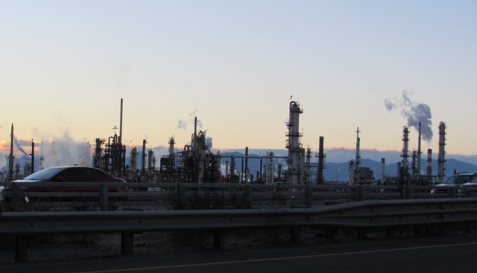
Sunset in Commerce City, a fast-growing industrialized suburb just north of Denver where residents have coped for years with high levels of water and air pollution. Credit: Jerd Smith, Fresh Water News
By Jerd Smith
To better protect low-income, non-English speaking communities from environmental harm caused by industrial contamination and air and water pollution, the state should create an entity to coordinate environmental justice work among state agencies, according to recommendations from a special task force.
It should also use new community outreach tools, such as interpreters, bus tickets and childcare, to bring affected residents in to the work to advise on policy and rulemaking on environmental issues.
In 2021, Colorado lawmakers approved The Environmental Justice Act, which includes a permanent 22-member Environmental Justice Advisory Board. The board is charged with helping ensure that poor communities, as well as communities of color, are included in setting policy and that they benefit from efforts to clean up air and water in their neighborhoods and from fines levied on polluters.
In a day-long meeting Tuesday the board discussed several recommendations made by the task force that are intended to help the state fine tune and strengthen its environmental justice work.
The task force, also created by the act, finished its work late last year. Its recommendations ultimately would have to be approved by the legislature before any of them are implemented, according to Lubna Ahmed, an environmental justice policy advisor to the Colorado Department of Public Health and Environment, which houses the advisory board. When that might occur isn’t clear yet.
Newly elected State Rep. Elizabeth Vasquez, a democrat from the West Slope’s House District 57, which includes Glenwood Springs, said she is looking forward to reviewing any recommendations that may come to the legislature this year.
She said ensuring state agency-wide coordination of environmental justice work is critical. “The equity piece has been missing in Colorado,” Vasquez said, “especially as we think of everyone having access to clean air and clean water, which is not a reality in many places in this state.”
Vasquez also said using new models of community engagement will be key in bringing justice to these communities.
“I come from grassroots organizing. That model is needed at every level of government,” she said.
Key to the state’s efforts is how to define which communities are likely to be “disproportionately impacted,” by pollution. This designation is important because it allows communities to qualify for grants and imposes rules on state agencies for community outreach and data analysis, among other things.
In the act, lawmakers defined these communities as those in census block groups that are either more than 40% low income, more than 40% people of color, or more than 40% burdened by housing costs. Communities with a history of environmental contamination and where economics have contributed to poor public health are also included in the definition.
Other key work of the advisory board is reviewing and approving grant applications for community based environmental justice programs.
The board is accepting the first round of applications through Feb. 3. Information on the application process can be found here. It plans to award $1 million this year. More money will be provided in subsequent years, eventually reaching $2.5 million, which will be derived from penalty revenues, according to a CDPHE spokeswoman.
But the ongoing environmental justice work will likely require more funding from state lawmakers, according to the task force.
Rep. Vasquez said she would support any effort to secure additional funding.
“We need to invest in things that are a priority for us,” she said. “Sometimes changes are costly. I know that we have to be smart and find that money.”
Jerd Smith is editor of Fresh Water News. She can be reached at 720-398-6474, via email at jerd@wateredco.org or @jerd_smith.
Fresh Water News is an independent, nonpartisan news initiative of Water Education Colorado. WEco is funded by multiple donors. Our editorial policy and donor list can be viewed at wateredco.org.
The Water Desk’s mission is to increase the volume, depth and power of journalism connected to Western water issues. We’re an initiative of the Center for Environmental Journalism at the University of Colorado Boulder. The Water Desk launched in April 2019 with support from the Walton Family Foundation. We maintain a strict editorial firewall between our funders and our journalism.
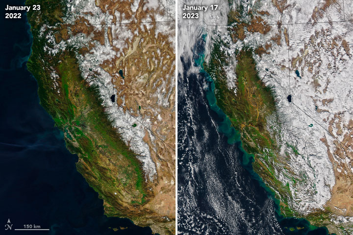
Before and after images acquired by NASA’s Aqua satellite reveal the impact of the storms that drenched California between Dec. 27 and Jan. 16. Snowpack is much more extensive on Jan. 17, 2023 (right) than on Jan. 23, 2022 (left). After all the precipitation this year, green swirls of sediment can also be seen billowing into the Pacific Ocean. (Please see below for an animation of these two images. Credit: NASA Earth Observatory)
By Tom Yulsman
The La Niña threepeat wasn’t supposed to turn out like this. The third La Niña winter in a row was expected to drive rain and snow away from much of California, significantly worsening an already brutal drought.
Instead, nine atmospheric river storms battered the state from Dec. 27 to Jan. 16, triggering flooding, mudslides, sinkholes — and, tragically, at least 20 deaths. Some areas received close to their annual precipitation in just those three weeks. Averaged over the entire state, the precipitation totaled 11.47 inches, according to the Weather Prediction Center of the National Weather Service. That’s nearly 50 percent of the precipitation the state receives in an entire water year.
The atmospheric rivers also pumped copious moisture into the Colorado River Basin, with many locations seeing their wettest or near-wettest conditions on record for January, according to the Colorado Basin River Forecast Center. In a tweet, the center noted that “if conditions hold through winter, we can expect above-average streamflow forecasts throughout the #ColoradoRiver Basin.”
But that’s a big “if.” And even above-average streamflow wouldn’t be enough to reverse the fortunes of a vast region of the West starved for water over the course of years. “To begin to alleviate long-term hydrologic drought and contribute to spring and summer runoff, snow needs to continue to accumulate during the winter,” notes a special drought status update published Jan. 24 by NOAA. Moreover, it will take above-average precipitation over the next three to five years, plus better management of water consumption, “to completely alleviate long-term hydrologic drought,” the update states.
An animation of two images captured by NASA’s Aqua satellite shows a huge difference in snow cover stretching from California’s Sierra Nevada range east into the Great Basin. The “before” image was acquired on Jan. 23, 2022, and the other on Jan. 17, 2023. As of Jan. 22 this year, the snow water equivalent for the California region was 215 percent of average for the date. But dry and warm conditions in coming months could erase these gains. (Credit: Images from NASA. Animation by Tom Yulsman)
All in all, the drenching we saw in late December through mid-January seemed much more like an El Niño, La Niña’s opposite. What happened?
A simple answer is that when it comes to weather, stuff just happens — La Niña be damned.
“Sometimes other processes can intervene and overwhelm the signal from La Niña,” says Marty Ralph, Director of the Center for Western Weather and Water Extremes at the Scripps Institution of Oceanography. “That’s how the atmosphere works.”
But what about the details? Just how did La Niña’s signal get overwhelmed? To understand that, it helps to consider these five things: different dimensions of time, a game of chance, a roiling cauldron, a butterfly, and us — specifically, the impact we’re having on the climate.
First off, just what is La Niña and how does it influence our weather?
In a nutshell, La Niña and El Niño comprise one of our planet’s most consequential climate phenomena: the see-sawing El Niño-Southern Oscillation, or ENSO. La Niña itself is characterized by cooler than normal sea surface temperatures along the equator in the Pacific Ocean. This is accompanied by changes to wind and storm patterns, including atmospheric rivers — long columns of moisture that can carry the equivalent of 15 times the average flow of water at the mouth of the Mississippi River.
“Atmospheric rivers impacting the North American West Coast typically occur in the wintertime,” says Marybeth Arcodia, an expert in climate variability at Colorado State University. So the fact that they occurred this winter is not unusual.
But one impact of La Niña is a tendency for a strong ridge of high atmospheric pressure to form over the northeast Pacific Ocean. This, in turns, shifts storm tracks northward, favoring wet winters in the Northwest and dry winters from roughly the southern half of California into the Southwest, across to Texas, and beyond. (For the northern half of California, there are typically equal chances for a dry or wet winter during a La Niña.)
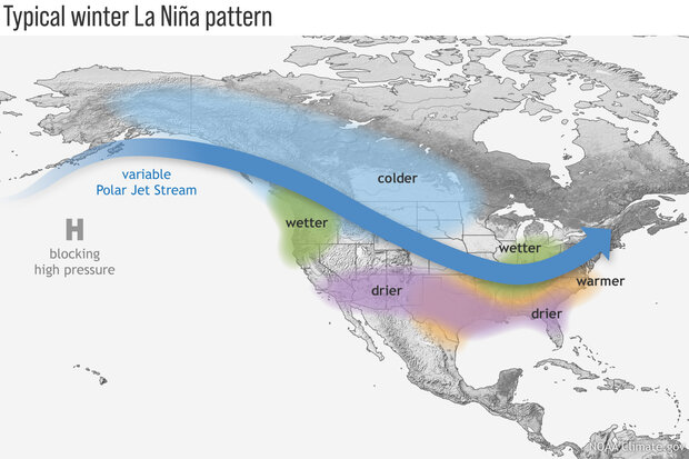
La Niña tends to result in strong ridge of high atmospheric pressure in the Northeast Pacific. Like a boulder in a river, it changes the flow of storms as they approach North America, favoring wet winters in the Northwest and dry winters across the southern United States. But in late December through mid-January, this typical La Niña pattern wasn’t in place. (Credit: NOAA)
Yet as 2022 transitioned to 2023, all of California got drenched. And that brings us to different dimensions of time.
La Niña occurs on a timescale that stretches over the course of entire seasons — and with this La Niña, three years. Meanwhile, “the flooding from these atmospheric rivers has happened in just a matter of weeks,” Arcodia observes.
Her point is that a climate phenomenon like La Niña works over a much longer period than individual storms, which happen day-to-day and week-to-week. In fact, for the first two years of this La Niña threepeat, much of California and the southwestern United States were starved of winter precipitation. But on the shorter timescale of a few weeks in December and January, individual weather events managed to punch through La Niña’s longer-term influence.
“If you have a La Niña ridge of high pressure off the West Coast, sometimes an atmospheric river can cut under it for a day or two and pummel Southern California,” Ralph says.
But in this case, of course, there was a parade of those rivers for three straight weeks. To delve more deeply into how this happened, let’s consider a simple game of roulette.
When played in a casino, you have a greater than 97 percent chance of losing a bet in roulette. But that doesn’t mean you can never win. If you had enough money to keep trying, sooner or later you’d probably cash in.
Similarly, just because the odds tilt against the southern half of California winning a lot of moisture during a La Niña winter doesn’t mean it will never experience a moisture win. The climate phenomenon comes with no guarantees, only odds. That point is driven home by the La Niña winter of 2016-2017, when all of the Golden State won the precipitation jackpot and went on to experience its third wettest year on record.
So, at a simple level, California’s experience during late December through mid-January is just one of those things that happens from time to time, due to an unlikely but entirely possible throw of the atmospheric dice. (Once again, stuff happens…)
But to answer the more complex question of just how short-term weather patterns ganged up to overcome the odds imposed by La Niña, let’s take a step back to consider the big picture — and how it resembles a pot of bubbling liquid.
Seen from space, rushing atmospheric rivers, whirling bomb cyclones, and blossoming supercell thunderstorms can leave the impression that the atmosphere we live in is indeed akin to a cauldron of roiling stew. And that’s not so far off the mark. From the point of view of physics, the atmosphere acts as a liquid, with the sun providing the flame to get things going. But even as we’re drenched, whipped, and often scared out of our wits by severe weather, we may well be unaware of features in the atmospheric cauldron that drive storms toward us.
These drivers include the constant bubbling up and down of atmospheric pressure. When a high pressure area is born, it typically grows into an elongated shape — a ridge in the atmosphere — with winds circulating around it in a clockwise direction. After California’s onslaught of storms ended in January, a La Niña-like ridge of high pressure became ensconced along the U.S. West Coast, bringing fair weather and shunting rainfall far to the north. (Will it stay there? Keep reading…)
By contrast, an area of low pressure typically takes the form of trough — which is why meteorologists call it just that. In the Northern Hemisphere, winds around a low within a trough flow counterclockwise, often bringing stormy weather.
Ridges and troughs are outlined by the flow of the jet stream, a relatively narrow band of strong wind in the upper levels of the atmosphere. (There are actually multiple jet streams; I’m talking about what’s known as the “polar” jet stream.)
The pattern is akin to ocean waves. And like ocean waves, the ridges and troughs normally aren’t stationary. Although sometimes they can become stuck, most of the time, they move, just like ocean waves, progressing slowly from west to east, dissipating and reforming, all the way around the globe. (The flow of air in the jet stream itself is much faster than the stately procession of the ridges and troughs themselves.)
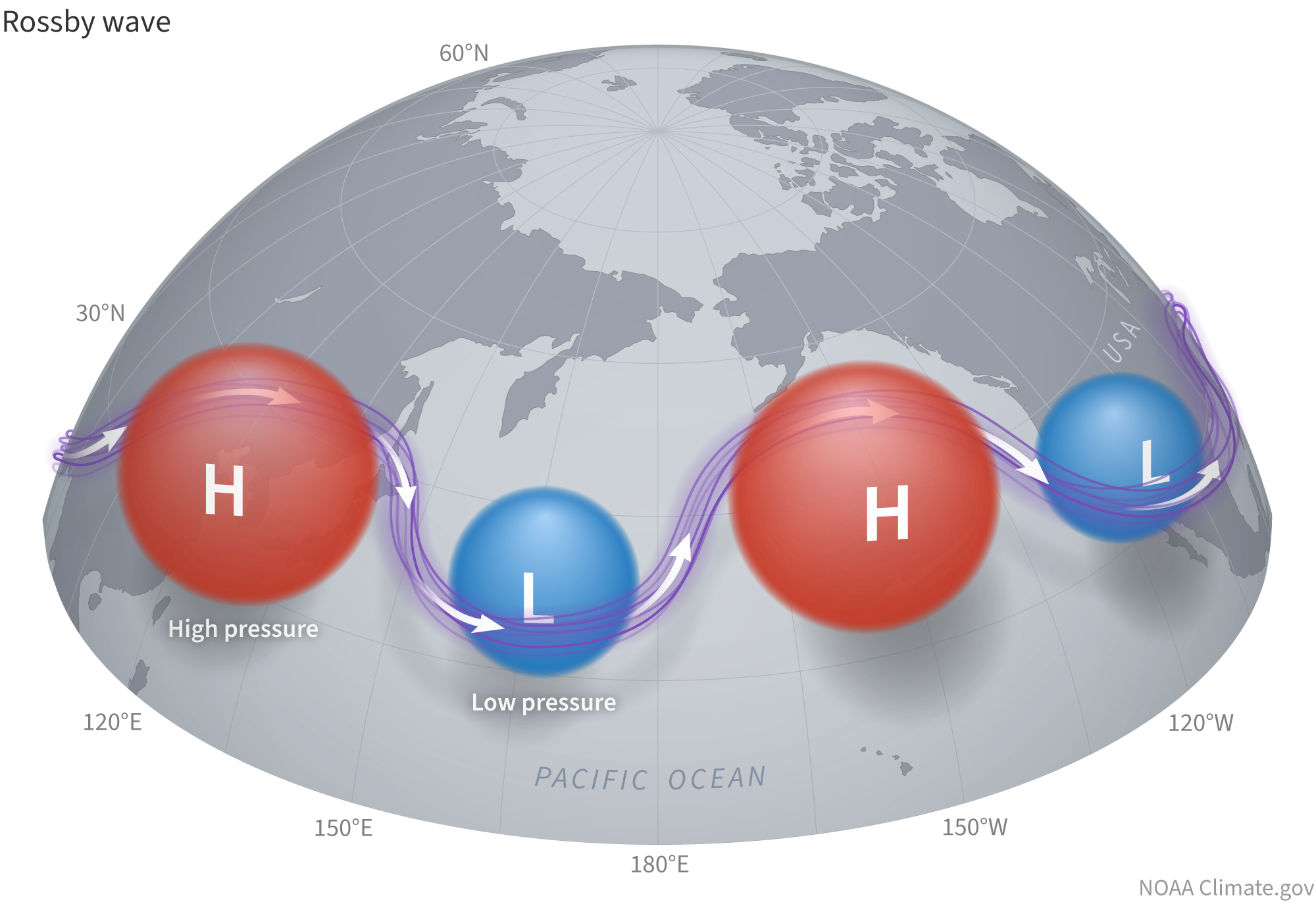
These large-scale features don’t just look like waves. They are waves — in the atmospheric cauldron. Scientists call them Rossby waves, after meteorologist Carl-Gustaf Arvid Rossby, who first identified them.
When a Rossby wave perturbs the Northern Hemisphere mid-latitude jet stream, warmer, high-pressure air is transported poleward into the wave crests, which are called ridges. Cooler, lower-pressure air is transported equatorward into the troughs. (Credit: NOAA Climate.gov)
“Rossby waves and the jet stream are two separate, but intimately connected, entities,” says Breanna Zavadoff, an atmospheric scientist at the University of Miami. As the waves form, grow, shrink, move, and reform, they interact with the jet stream, affecting where it is positioned and how wavy it is, thereby shaping the weather we experience.
During winter in La Niña years, these interactions tend to produce a wavier pattern than in neutral years. And in the Pacific, that wavy pattern often results in the persistent ridge of high pressure over the northeastern part of the ocean. Combined with other factors, this can help funnel very moist winds from the subtropics near Hawaii into atmospheric rivers aimed at the Pacific Northwest.
As you might imagine, a bubbling up or down of pressure can occur here, there, or anywhere, either by chance, or possibly even due to us. (More about that in just a bit.) And with just that small change in initial conditions, a chain of events can be touched off in the atmosphere that eventually has big effects thousands of miles away.
Something like that happened a few weeks before California’s battering by atmospheric rivers: a bubbling up of strong thunderstorm activity in the Indian Ocean. It was part of a phenomenon called the Madden-Julian Oscillation, or MJO, and Ralph believes it played a major role in what happened.
Whereas La Niña, and its opposite, El Niño, are stationary, and occur on a timescale of entire seasons, MJO moves, and its impacts occur more on a weekly timescale. It consists of a disturbance of clouds, rainfall, winds, and pressure changes that moves eastward in the tropics, circling the entire globe in about 30 to 60 days, on average.
The storminess Ralph observed in the Indian Ocean was part of this pattern. As it moved east into the tropical Pacific, thunderstorm activity caused water vapor to rise high into the atmosphere. As the water vapor cooled at altitude and condensed to form billowing clouds, large amounts of latent heat were released.
“This is a massive forcing of the atmosphere in a manner that sends Rossby waves to the northeast in the Pacific Basin,” Ralph says. And as we’ve seen, these waves — troughs and ridges — play a leading role in the weather we experience. That includes where atmospheric rivers, or ARs, make landfall.
But the MJO phenomenon doesn’t always result in the southern part of California getting drenched. Other factors play a role too, and the interplay is complex. Ralph and his colleagues at Scripps have developed a tool designed to tease apart the details of that interplay and thereby enable forecasters to better predict what might happen when an MJO is in place.
“We’re just kicking the tires on it right now,” he says. The goal is to use the tool “to determine whether the odds are tilting toward ARs two to three weeks ahead.”
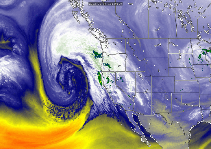
In early January, after the MJO storminess moved from the Indian Ocean into the tropical Pacific, a now infamous bomb cyclone erupted and moved toward California. “Its minimum air pressure plummeted by about 3 percent in 24 hours, signifying a vacuum-like ingestion of air… resulting in strong inward winds,” wrote Washington Post meteorologist Matthew Cappucci and science journalist Diana Leonard at the time.
An infrared view of water vapor in the atmosphere acquired by the GOES-18 satellite, overlaid with NEXRAD weather radar data. This combination shows the impact of the bomb cyclone and atmospheric river storm that battered California and other parts of the West Coast on Jan. 4 and 5. (Credit: SSEC RealEarth)
This vacuuming in of air by the storm happened in a trough bounded by a very big downward dip of the jet stream that wound up ideally positioned to direct rivers of moisture from the subtropics into California. In subsequent weeks, new storms formed and helped direct yet more atmospheric rivers over the state.
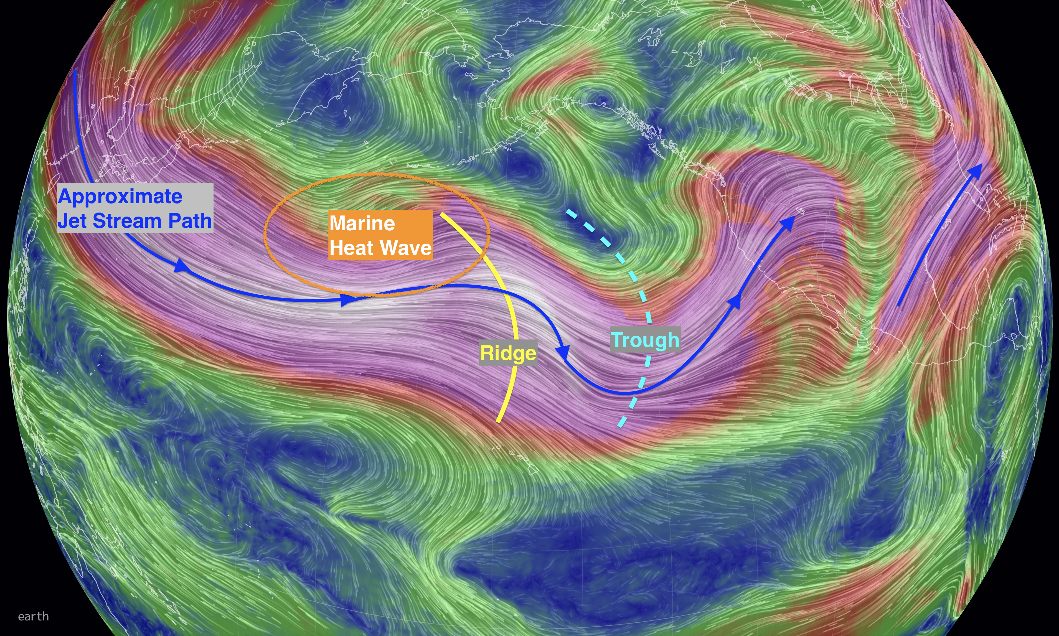
The eastward-moving disturbance of the MJO cited by Marty Ralph may not have been the only factor at play. As California was getting hammered, Jennifer Francis, Senior Scientist at the Woodwell Climate Research Center, was taking note of another phenomenon far from California: a sprawling area of abnormally warm surface water called a “marine heatwave” in the northern Pacific, south of Alaska’s Aleutian Islands. She also noted that the typical wavy pattern of the jet stream during a La Niña was not in place.
The jet stream was flowing straight east from Japan at the time. “But when it hits the heatwave area, it buckles,” Francis said in an email message. “A ridge forms over the heatwave, and then a trough forms downstream,” to the east. This pattern persisted, with the trough “creating the parade of storms striking the U.S. west coast.”
Roughly approximated here are the locations of a marine heatwave in the northern Pacific, a ridge of high atmospheric pressure, and a low-pressure trough, along with the path of the jet stream, on Jan. 9, 2023. This pattern helped direct a river of atmospheric moisture at California. (Credit: earth.nullschool.net with annotations by Tom Yulsman)
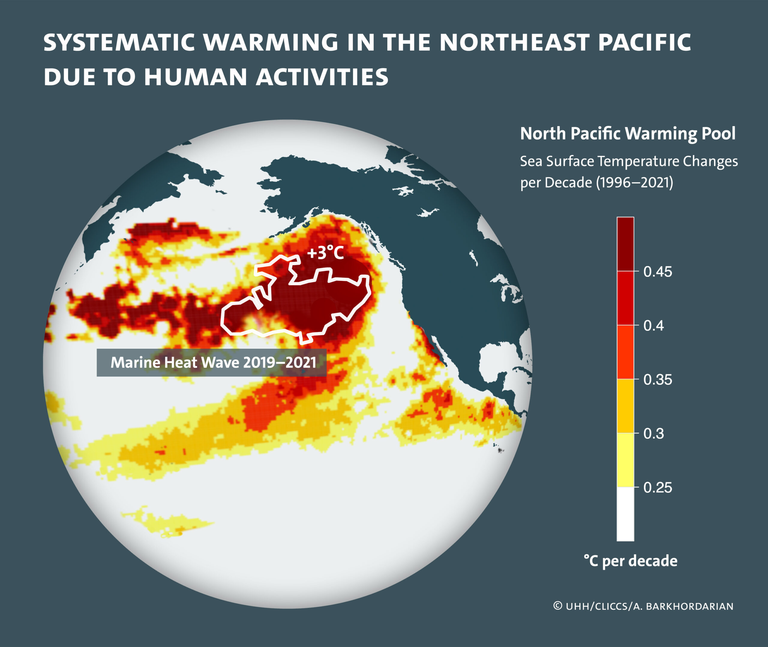
Climate change may well have something to do with this. Scientists recently discovered a pool of warming water in the northern Pacific sprawling across more than 1.1 million square miles — an area equivalent to about a third of the contiguous United States. Using observations and computer modeling, the researchers investigated what was behind this “warming pool.” They concluded that increasing greenhouse gas levels in the atmosphere have been a key cause. Another human influence — this one laudable — played a role too: decreases in aerosol pollution from industry and vehicles.
The warming pool has had significant impacts on the region. For example, over the last two decades, summers have averaged 1.5 °C warmer and 37 days longer, according to the researchers. They also found that the warming pool has been encouraging the formation of marine heatwaves — along with weather-altering ridges of high atmospheric pressure above them — like the one noted by Jennifer Francis.
With greenhouse gas levels in the atmosphere continuing to rise, we can well imagine what’s to come. “This warming pool will continue to increase the water temperature in the future, increasing both the frequency and intensity of local marine heatwaves,” says lead author Armineh Barkhordarian of the University of Hamburg, quoted in a release.
Francis agrees: “I think ocean heatwaves will only increase in frequency, intensity, and spatial extent as we continue to augment concentrations of greenhouse gases.”
Given what we’ve seen this year and in the past from marine heat waves, it’s plausible that weather impacts could grow even more intense as they worsen. What might that mean for California? It’s difficult to say, according to Francis. So many different factors are at play that it will take further research to tease out what the impacts might be, and where and when they might occur.
Regardless, what happened in December and January does provide some solace: The intensity of California’s drought has eased somewhat, depleted reservoirs have gotten desperately needed inflows, and a healthy snowpack has built up in the Sierra Nevada Range, and to the east. Even so, California’s water woes continue. As of Jan. 17, more than 90 percent of the state was still in drought.
It’s possible that the current dry pattern along the West Coast will continue, and conditions will look a whole lot more like La Niña in the remaining months of winter and heading into spring. That would undercut gains that California and parts of the Colorado River Basin have made so far. There’s ample precedent for this. In December 2021, parts of the Sierra experienced record snowfall, despite La Niña. But then conditions took a radical turn, with the driest January, February, and March in more than 100 years.
At the same time, there is a glimmer of hope for a different outcome. “There are some very preliminary hints of a shift,” with increased activity of atmospheric rivers coming in February, Ralph says. The caveat is that when looking ahead more than about a week, uncertainties mount, so the shift may not pan out. “But the odds are in favor of getting back into a wet mode.”
Let’s hope it happens more gently this time.
The Water Desk’s mission is to increase the volume, depth and power of journalism connected to Western water issues. We’re an initiative of the Center for Environmental Journalism at the University of Colorado Boulder. The Water Desk launched in April 2019 with support from the Walton Family Foundation. We maintain a strict editorial firewall between our funders and our journalism.
Autumn view of the wetlands and cottonwood groves in the Yampa River basin at Carpenter Ranch, located west of Steamboat Springs, Colorado. Photo courtesy of The Nature Conservancy
By Caitlin Coleman
A race is on to determine which wetlands and other waters will be protected under the Clean Water Act, the law that regulates the discharge of pollutants into the nation’s water. At issue is not only the protection of water bodies but also clarity for farmers, ranchers, developers, and others who question whether the actions they take on their lands require a federal permit.
On October 3, the U.S. Supreme Court heard Sackett v. EPA, a case that asks whether certain wetlands are protected under the Clean Water Act and how that should be determined. The Supreme Court offers no specific timeline as to when it will release an opinion, aside from by the end of this term in June 2023, or sooner, but likely not before January 2023.
“The magnitude of this Supreme Court case can’t be overstated,” said Ashley House, director of public policy national affairs for the Colorado Farm Bureau. “It’s a matter of food security.” But it’s also a matter of protecting the state and nation’s water resources.
In Colorado there is no state program to protect certain wetlands and waterways from dredging, filling and other damage if they’re not covered by the Clean Water Act. The state has always relied on the federal government’s program for dredge and fill permits, though it could develop its own protections if needed.
Over the past seven years, the test for which water bodies are protected under the Clean Water Act has changed three times – with each new presidential administration – as certain categories of wetlands and ephemeral streams have been revised in and out of the definition for “waters of the United States,” also known as WOTUS, a federal status that extends them protections under the Clean Water Act.
Now, the U.S. Environmental Protection Agency and the Army Corps of Engineers are developing another new rule that would also clarify which waters are protected from pollutants under the act. The agencies’ final rule was submitted in September 2022 and, according to EPA, the agencies plan to issue the rule by the end of the year.
Recent changes to the definition of WOTUS occurred in 2015, 2020 and 2021, with another likely coming in 2022. Those recent definitions for what qualifies have bounced between broader and narrower.
“A narrow definition of waters of the U.S. leaves an incredibly important water resource value unprotected by federal law — which is basically uniform across the nation — and then it’s up to the states to decide what to do, and some states won’t decide to protect those areas at all,” said Joro Walker, general counsel with Western Resource Advocates.
The 2020 definition, for example, excluded all ephemeral waterways and some wetlands. Ephemeral streams represent more than 25% of Colorado’s stream miles, according to Colorado Trout Unlimited.
But farmers and ranchers, developers, and other business owners worry the broader definition would mean federal involvement in day-to-day decisions around their properties, or the need to consult a lawyer on something like driving across an ephemeral stream or running water through an irrigation ditch every few years. The 2015 rule included a broad definition and has been referred to as a federal “overreach.” Sen. John Barrasso (R-Wyo.) said in 2019 that the rule would have put “backyard ponds, puddles, and prairie potholes under Washington’s control.”
Now though, the Colorado Farm Bureau and others who are regulated are calling for clarity and security, something they hope the Supreme Court will provide.
“It’s hard to know what is covered,” said Travis Vincent, general counsel and director of public policy state affairs for the Colorado Farm Bureau. “We want a more bright-lined test so our members have a better understanding of when their property or something on their property would be regulated under WOTUS.”
The organization is also looking for more stability.
“On the existential level it creates a lot of anxiety when you have changes to the definition with every changing administration. There’s a sense of anxiety with all producers,” said House. “Producers need accountability and also regulatory consistency.”
Currently, EPA and the Army Corps of Engineers are relying on the definition that was in place through 2015, which they call a “familiar approach” that will “support a stable implementation of ‘waters of the United States’” while EPA and the Army Corps continue their rulemaking.
According to a statement issued by EPA, the new rule will include “amendments to reflect the agencies’ determination of the statutory limits on the scope of the ‘waters of the United States’ informed by Supreme Court precedent, the best available science, and the agencies’ experience and technical expertise.”
But the Supreme Court’s decision could change that. If the Supreme Court issues a decision before EPA finalizes its rule, the agency would likely need to adjust its rule before issuing it. If EPA’s call comes first, it could render the court’s decision moot, or mean that the agencies need to go back to the drawing board after the court’s decision is released. Both the court’s opinion and the rulemaking could affect EPA’s regulatory process and the level of protection that water bodies receive.
“We are in a very dynamic situation with the rule and have been for a number of years,” says Trisha Oeth, director of environmental health and protection at the Colorado Department of Public Health and Environment. “I think all interests would benefit from certainty and stability in this area, so we continue to watch it very closely and have been having conversations with stakeholders here in Colorado to figure out, long term, what is the right path for us.”
In Colorado, not all changes to the rule have been implemented. A month after the 2020 revision took effect, which rolled back protections, Colorado filed a legal challenge. According to Colorado’s Water Quality Control Division, some 25% to 50% of Colorado streams, lakes and wetlands could have been impacted by the 2020 rule. Colorado’s attorneys initially secured a stay on enacting the new rule and absorbing more enforcement responsibilities, but that ruling was vacated by the Tenth Circuit Court in March 2021.
In 2021, the nation reverted back to the pre-2015 rule but just after that, in January 2022 the Supreme Court agreed to review Sackett v. EPA, which questions whether certain wetlands are waters of the United States. The Sacketts own land in Idaho which lies across from wetlands and drains into a tributary that feeds Priest Lake. They had long been trying to build there but EPA and the Army Corps of Engineers found that the dredging and filling of construction would affect the tributary and lake.
When the case went to the U.S. Court of Appeals, the court upheld EPA’s conclusion, based on a test established through a 2006 Supreme Court case, Rapanos v. United States, in which Justice Kennedy argued that the Army Corps of Engineers should determine whether the water at issue possesses a “significant nexus” to waters that are navigable when determining whether a water body meets the definition of WOTUS.
But in the Rapanos case, justices failed to achieve a majority opinion on the WOTUS test. This has left, as the Sacketts have said, a landscape of “fruitless confusion, conflict, and litigation.”
The Sacketts appealed the Court of Appeals’ decision to the Supreme Court. The Sacketts aren’t alone in standing up to EPA on its decision. In April 2022, the Colorado Farm Bureau joined 19 other state Farm Bureaus in filing a brief with the court in support of the Sacketts.
More than 40 additional briefs in support of either EPA or the Sacketts have been filed by many other parties, including the State of Colorado, which filed a brief in June arguing for broad protection of waters and for the use of the “significant nexus” test in determining which waters to protect.
Although the court has heard oral arguments, it remains unclear where the justices will side and whether they will come together to provide a new, definitive test for WOTUS jurisdiction.
“It’s hard to speculate on what the [U.S. Supreme Court decision] is going to look like,” said Oeth. “If the outcome were to change the definition of WOTUS or add a new test for what WOTUS includes, that could have an impact here in Colorado.” If a new definition were to apply to fewer water bodies than it does now, that would mean that Colorado waters would have less protection than they do today, she said.
Elizabeth Miller contributed to this report.
Caitlin Coleman is a contributor to Fresh Water News and is editor of Water Education Colorado’s Headwaters Magazine. She can be reached at caitlin@wateredco.org.
Fresh Water News is an independent, nonpartisan news initiative of Water Education Colorado. WEco is funded by multiple donors. Our editorial policy and donor list can be viewed at wateredco.org
The Water Desk’s mission is to increase the volume, depth and power of journalism connected to Western water issues. We’re an initiative of the Center for Environmental Journalism at the University of Colorado Boulder. The Water Desk launched in April 2019 with support from the Walton Family Foundation. We maintain a strict editorial firewall between our funders and our journalism.
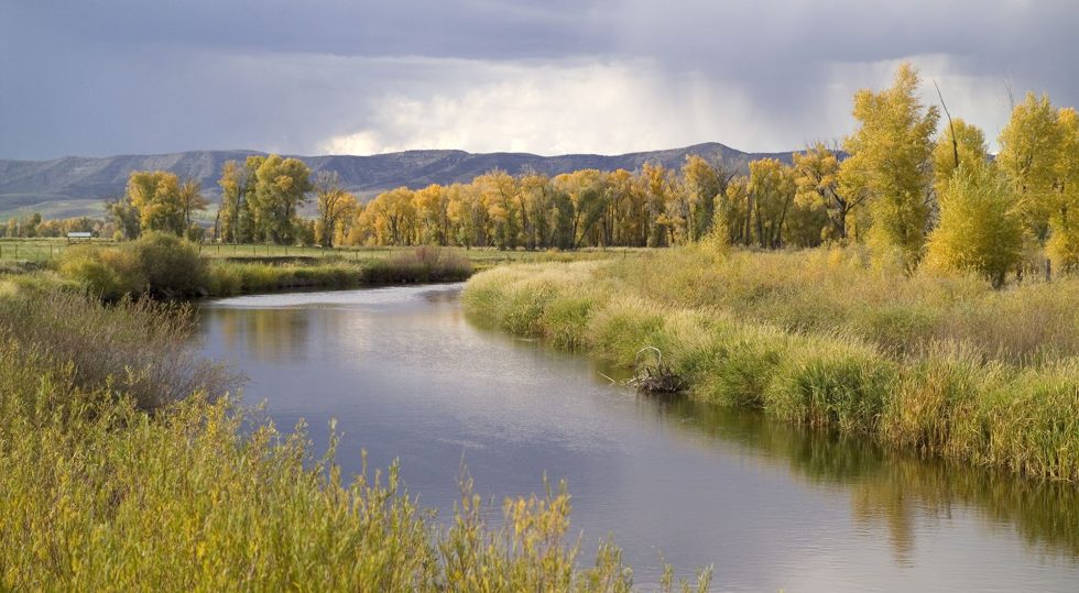
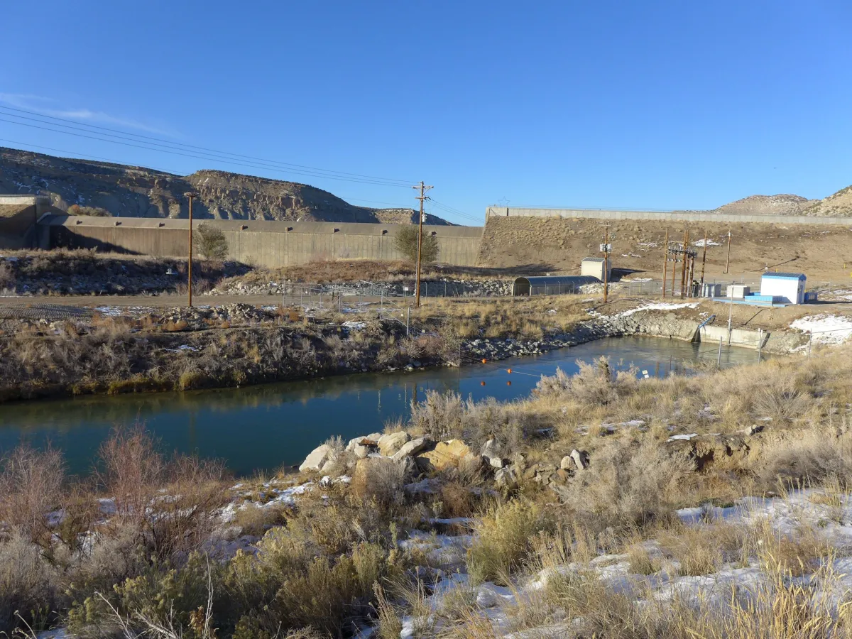
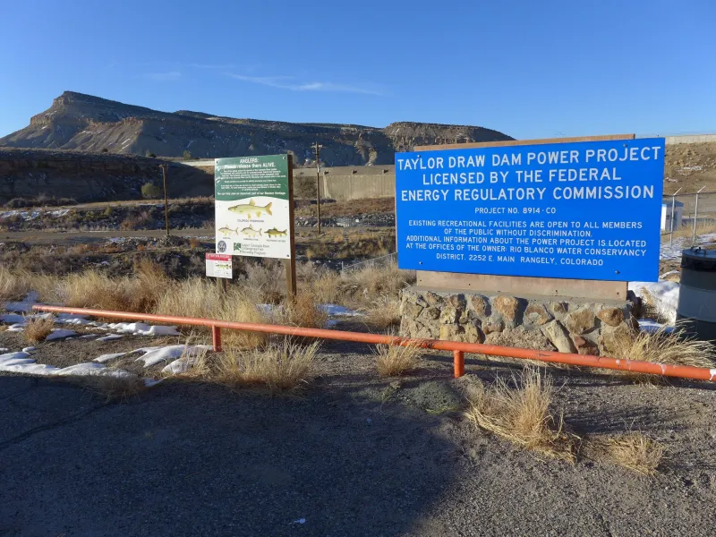
Taylor Draw Dam on the White River in northwest Colorado forms Kenney Reservoir. The dam has a hydropower facility tied to a 1966 water right for 620 cfs. CREDIT: HEATHER SACKETT/ASPEN JOURNALISM
By Heather Sackett
A water conservancy district has put a call on the White River, an action that has the potential to alter the system for other water users.
On Dec. 1, the Rangely-based Rio Blanco Water Conservancy District placed a call for its water right of 620 cubic feet per second at the Taylor Draw Dam hydroelectric plant, which the district owns and operates. It is only the second-ever call on the White River. A call occurs when a water rights holder isn’t getting the full amount of water to which they are entitled and upstream water users are shut off or “curtailed” so that the downstream user can get their full amount.
“I think maybe it’s a little strong to say it’s going to be life-changing, but it’s going to be significant, especially if we start seeing a call year-round,” said Colorado Division of Water Resources Division 6 Engineer Erin Light. “I think it could really change the regime that everyone in that basin is accustomed to. I think there’s not much question that the basin would become overappropriated.”
DWR designated the nearby Yampa River basin as overappropriated earlier this year, which means that there’s more water on paper than real water in the system at certain times of year and new well users will have to get a water-replacement plan, known as an augmentation plan.
Under Colorado water law, older water rights get first use of the river. In this case, water users junior to the district’s 1966 water right are being shut off. This time of year, that mostly means some industrial users and those who pull water from the river to water their livestock but who don’t have a water right for that specific use, Light said.
Under Colorado water law, watering livestock from ditches during irrigation season is included under an irrigation water right. But in the winter, when fields are not being irrigated, ranchers need a separate decree specifically for livestock watering if they want to continue using their ditches to water the animals.
The Rangely-based Rio Blanco Water Conservancy District has placed a call on the White River for its 620-cfs water right at the hydropower plant. Division of Water Resources staff have shut off water to some upstream users who water their livestock with ditches in the winter.CREDIT: HEATHER SACKETT/ASPEN JOURNALISM
Reduced hydropower revenues
According to a news release from the district, the ongoing drought has significantly reduced seasonal inflows into Kenney Reservoir, which has reduced power production at the dam. According to the district, electricity production has been reduced by 35%, which has reduced the district’s revenues.
District General Manager Alden Vanden Brink said in an email that the district’s full water right was not being met several months out of the year and that the call will remain on until the full water right or capacity of the turbine is met. The district also has a 1982 water right for 125 cfs.
The news release said the district is sensitive to the hardships that the call may have on other water users and is working to create a White River augmentation plan, with a backup water supply for junior users.
Light said her office has curtailed about 10 ditches and two industrial water users since the call came Dec. 1, but assuming the call will be on whenever the river flows at less than 620 cfs, there will be more water rights and water usage curtailed in the summer and fall. During the irrigation season, there will be about 500 ditches and pumps that water commissioners will have to visit to see how much water they are using and whether they are using it legally, she said.
The U.S. Geological Survey stream gauge on the White River above Rangely is currently ice-affected and not giving a reading, but Light said she is certain that the 620-cfs water right at the dam is still not being met, even with curtailing upstream junior users. The river is probably running at about 300 cfs going into Kenney Reservoir, she said. Stream gauge data over the last half dozen years show that outside of seasonal peak flows, the White River near Rangely normally runs below 620 cfs.
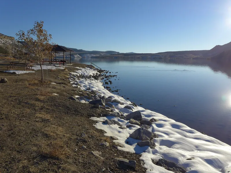
Kenney Reservoir, five miles east of Rangely, in October 2020. The Rio Blanco Water Conservancy District owns and operates the reservoir.CREDIT: HEATHER SACKETT/ASPEN JOURNALISM
Wake-up call
The White River flows from the Flat Tops west through Meeker and Rangely to its confluence with the Green River in Utah. This sparsely populated basin has seen little regulatory oversight from the state, and water users could generally take as much water as they needed. But that is changing. For the past few years, Division 6 staffers have been pushing water users to install measuring devices on their ditches and canals.
“In Division 6, our basin that has the most number of structures by far without measuring devices is the White River,” Light said. “Unfortunately, probably at the onset of this call in the summer, we will be shutting people off without measuring devices.”
Will Myers is an engineer and rancher on the Williams Fork, a tributary of the Yampa River, and he also serves as the agriculture representative on the Yampa/White/Green Basin Roundtable. Getting a water court decree for stock watering is the best way for agricultural producers to protect their practices, he said, especially in an area not used to strict administration by state officials because there has historically been enough water to go around.
“Any time you have something like this happen, it’s kind of a wake-up call for those in the ag community,” Myers said. “Just because you’ve always done something doesn’t mean you’re not susceptible to an actual legit administrative call.”
Ongoing drought and the impacts of a warming climate are at least partially fueling a trend in never-before-seen calls in parts of western Colorado. In 2018, the Yampa River saw its first-ever call, and the Crystal River saw its first-ever senior irrigation call.
“If that’s indeed true — that we are going to continue to see a drying climate — we are going to continue to see senior water rights not being met,” Light said. “I think that’s become clearly evident in the last four years.”
Aspen Journalism covers water and rivers in collaboration with The Aspen Times. This story ran in the Dec. 12 edition of Steamboat Pilot & Today and the Craig Press.
The Water Desk’s mission is to increase the volume, depth and power of journalism connected to Western water issues. We’re an initiative of the Center for Environmental Journalism at the University of Colorado Boulder. The Water Desk launched in April 2019 with support from the Walton Family Foundation. We maintain a strict editorial firewall between our funders and our journalism.
River guide John Saunders paddles a boat down the Yampa River in May 2021. Colorado’s recreation community is asking the state for more inclusion in the updated Water Plan, a final draft of which is scheduled to be released in early January.
By Heather Sackett
Colorado’s river recreation community is asking for more recognition in the update to the state’s Water Plan.
In a Sept. 30 comment letter addressed to the Colorado Water Conservation Board Director Rebecca Mitchell and Gov. Jared Polis, a group of recreation, environmental conservation organizations and local businesses ask for river recreation to play a more prominent role in the roadmap for Colorado’s water future.
“Adequate flows to sustain recreation and environmental water needs must be a top priority for CWCB,” the letter reads. “As the update notes, climate change and aridification will contribute to significant temperature-driven river flow declines, disproportionately impacting recreation and river health.”
State officials in July released the second iteration of the Colorado Water Plan, a 239-page document that lays out four interconnected areas for action: vibrant communities, robust agriculture, thriving watersheds and resilient planning. The update to the original 2015 plan is a roadmap for how to manage Colorado’s water under future climate change and drought scenarios. CWCB staff said they are currently reviewing the 1,376 comments with about 2,000 observations and suggested revisions they received during the 90-day public comment period, which ended Sept. 30.
In the Colorado water world, recreation usually is lumped together with the environment as a “non-consumptive” use since both seek to keep water in the stream. But signatories to the letter say that grouping overlooks the importance of recreation to the economy.
“We are always talking about environment and recreation together because they are so interconnected, but in doing so we miss out on the larger picture of the importance of recreation and really the economic development aspect of it,” said Hattie Johnson, southern Rockies stewardship director of American Whitewater. “There is special care and special consideration that require a different way of looking at recreation that we feel is still lacking in the update.”
The letter gives six recommendations to better integrate recreation into the Water Plan: reaffirm that water-based recreation is not in conflict with other water uses; include the Colorado Outdoor Recreation Industry Office (OREC) as a collaborating agency; add a CWCB recreation liaison; address recreation flows and temperatures; include recreation in watershed planning; and approach storage and water development in a way that won’t negatively impact flows for recreation.
Despite its contribution to Colorado’s outdoor culture, tourism economy and lifestyle, recreation has struggled to find a foothold in the state’s system of water rights, which was established over a century ago and still reflects the values of that time. Colorado water law prioritizes the oldest water rights, which usually belong to agriculture and cities.
As coal mines close, some communities like Craig are turning toward healthy rivers as a way to transition from extractive industries to an outdoor-recreation-based economy.
“It’s important to note that recreation is a pretty important stream use for a lot of communities on the Front Range and West Slope,” said Bart Miller, healthy rivers program director for Western Resource Advocates. “Just having vibrant rivers running through town not just for people to go and float on, but for businesses and boardwalks and the heart of town for a lot of places.”
The update to the Water Plan recognizes that climate change presents a threat to the long-term viability of water-based outdoor recreation. Some communities like Steamboat Springs, where the Yampa River through town has been closed to recreation in recent summers due to high temperatures exacerbated by low flows, are already feeling the effects. Recreation proponents asked CWCB to address this issue.
“We recommend that the final update include specific actions CWCB will take to address recreation flows, including mitigating summer recreation closures caused by high water temperatures and better quantifying the gap for recreational and environmental flow needs,” the letter reads.
The upstream wave at the Roaring Fork Whitewater Park in Basalt is tied to a recreational in-channel diversion water right. As the only way to ensure a water right for recreation, it is an imperfect tool with some drawbacks.CREDIT: HEATHER SACKETT/ASPEN JOURNALISM
RICDs are imperfect tool
Neither of two recent proposals from recreation proponents — one that would have tied water rights to a natural stream feature and one that would have designated stream reaches for recreation, allowing them to lease water to boost flows — gained wide support from water users or legislators.
Currently the only way to keep water in rivers for boaters is for a local government to get a recreational in-channel diversion (RICD) water right for a human-made wave or whitewater park. But recreation proponents say this method is an imperfect tool. The process of securing the rights can be met with opposition and take years in water court. RICD water rights also sometimes end up making concessions to future water development.
Building the wave features is expensive, meaning a RICD water right may be out of reach for less-affluent communities. Pitkin County has spent more than $3 million on constructing and subsequently fixing its two waves with a RICD water right in the Roaring Fork River near Basalt; the project had an initial budget of $770,000.
The letter also suggests adding a staff position at CWCB to focus on solving the flows challenge and guiding the RICD program.
“A big idea we included was this idea of a recreation liaison,” said Alex Funk, director of water resources and senior counsel at the Theodore Roosevelt Conservation Partnership. “Having someone at CWCB that’s basically your recreation expert, someone that can handle the RICD program, work with the OREC office, someone who is more dedicated to that community and thinking through those things.”
The letter also recommends that recreation be included into watershed planning, specifically by including environmental and recreation flow target recommendations in stream management plans. The 2015 Water Plan had a goal of covering at least 80% of the state’s priority streams with SMPs. And although one of the original goals of these SMPs was to identify flow needs for recreational water uses, only 1% of the plans completed so far did so. In some cases, the SMP process was taken over by agricultural interests, watering down what was supposed to be a tool specifically for the benefit of non-consumptive water uses.
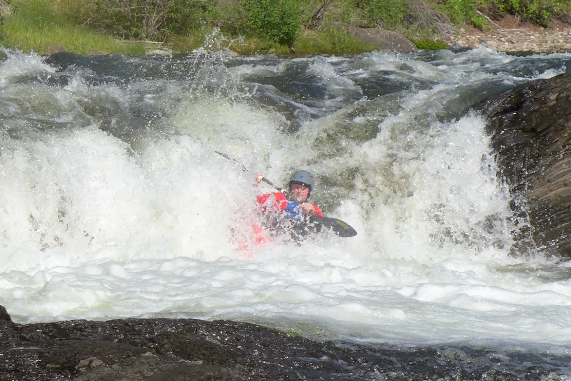
A kayaker runs the 6-foot drop of Slaughterhouse Falls on the Roaring Fork River near Aspen in June 2021. Recreation proponents gave six recommendations to the CWCB to better elevate recreation in the update to Colorado’s Water Plan.CREDIT: BRENT GARDNER-SMITH/ASPEN JOURNALISM
Coalition letter
The comment letter from recreation proponents was an add-on to a more-lengthy submission from the Water for Colorado coalition, which is made up of representatives of environmental advocacy groups including American Rivers, Audubon Rockies, The Nature Conservancy, Trout Unlimited and others.
Recreation was one of three key areas the 40-page letter focused its recommendations on. The letter lays out the criticism that environment and recreation are a secondary focus of the plan and that watershed health is merely “considered” in state water resource planning.
“While we agree that should be a minimum requirement, it doesn’t go nearly far enough,” the letter reads. “Environmental flows and watershed health must also be a coequal goal of state water resource planning itself — not just a secondary consideration.”
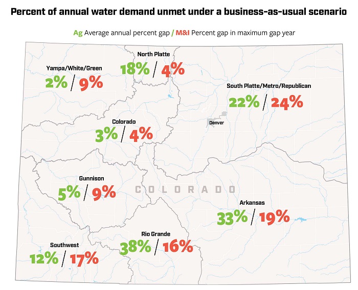
The update to the Water Plan lays out projected future “gaps” — the shortage between supply and demand — for agriculture and cities, but not for recreation or the environment.
“There’s not much detail about the volumes of water that are missing or needed,” Miller said. “We’ve got plenty of streams around the state that are short, and we will need to figure out how to improve their health through creative ways of reducing out-of-stream uses.”
CWCB Section Chief for Water Supply Planning Russ Sands said staff appreciates the in-depth feedback from the recreation community.
Sands acknowledged that although there are several locations across Colorado where non-consumptive streamflow needs have been identified, they have not been quantified statewide in the same way as they have been for agricultural or municipal demands. CWCB may revisit addressing those gaps during the next update to the Water Plan, he said.
Sands emphasized the fundamental need for the Water Plan to promote projects that benefit multiple water user groups: agriculture, the environment, recreation and cities.
“Climate change presents a long-term threat to the viability of all sectors of water use,” he said in an emailed statement. “The most promising tool to address this is radical collaboration.”
The final draft of the updated Water Plan is expected by early January.
The Water Desk’s mission is to increase the volume, depth and power of journalism connected to Western water issues. We’re an initiative of the Center for Environmental Journalism at the University of Colorado Boulder. The Water Desk launched in April 2019 with support from the Walton Family Foundation. We maintain a strict editorial firewall between our funders and our journalism.
Cattle of the Bow & Arrow herd, graze in a frosted corn field on the 7,770 acre Ute Mountain Ute Farm & Ranch Enterprise near Towoac, Colorado. About 700 head of cattle, graze on the farm and ranch lands during the winter. During the summer the herd is moved to mountain pastures. (Dean Krakel photo, special to EWC)
By Allen Best
At Spring Born, a greenhouse in western Colorado near Silt, you see few, if any, dirty fingernails. Why would you? Hands never touch soil in this 113,400-square-foot greenhouse.
You do see automation, long trays filled with peat sliding on conveyors under computer-programmed seeding devices. Once impregnated, the trays roll into the greenhouse.
Thirty days after sprouting, trays of green and red lettuce, kale, arugula, and mustard greens slide from the greenhouse to be shorn, weighed and sealed in plastic clamshell packages. Hands never touch the produce.
Spring Born says it needs 95% less water compared to leafy greens grown using Colorado River water a thousand miles downstream in Arizona and California. That region supplies more than 90% of the nation’s lettuce. At Silt, the water comes from two shallow wells that plumb the riverine aquifer of the Colorado River, delivering about 20 gallons per minute. The water is then treated before it is piped into the greenhouse. This is agriculture like nowhere else.
The all-mechanized operations at Spring Born’s large greenhouse near Silt, Colo., produce leafy greens by maximizing the use of water. Spring Born says it needs 95% less water compared to greens grown using Colorado River water 1,000 miles downstream in Arizona and California.From the Hip Photo courtesy of Spring Born.
Great precautions are taken to avoid contamination and prevent the spread of pathogens. Those entering the greenhouse must don protective equipment.
There’s no opportunity for passing birds or critters to leave droppings. As such, there is no need for chlorine washes, which most operations use to disinfect. Those washes also dry out the greenery, shortening the shelf life and making it less tasty. The Spring Born packages have an advertised shelf life of 23 days.
Spring Born likely constitutes the most capital-intensive agricultural enterprise in Colorado. Total investment in the 250-acre operation, which also includes traditional hay farming and cattle production, has been $30 million. The technology and engineering come from Europe, which has 30 such greenhouses. The United States has a handful.
Agribusiness in Colorado generates $47 billion in economic activity but it ties to one reality: The future is one of less water. So how exactly can agriculture use water more judiciously?
The Thirsty Future
A Desert Research Institute study published in April 2022 concluded that the warming atmosphere is a thirstier one. Modeling in the study suggests that crops in some parts of Colorado already need 8% to 15% more water than 40 years ago. Agricultural adaptations to use less water are happening out of necessity.
Colorado has warmed about 2.5 degrees Fahrenheit in the last 120 years. Warming has accelerated, with the five hottest summers on record occurring since 2000.
Higher temperatures impact the amount of snowfall and amount of snowpack converted to water runoff. “As the climate warms, crops and forested ecosystems alike use water more rapidly,” says Peter Goble, a research associate at the Colorado Climate Center. “As a result, a higher fraction of our precipitation goes into feeding thirsty soils and a lower fraction into filling our lakes, streams and reservoirs. Essentially, a warmer future is a drier future.”
This year was a good example of the drying trend.
Snowpack was around average in the San Juan Mountains, but spring arrived hot and windy. Snow was all but gone by late May, surpassed in its hurried departure only in 2018 and 2002. Farmers dependent on water from the Dolores River, still reeling from last year’s meager supplies, were required to accept lesser supplies yet again as the growing season began this year.
The Ute Mountain Ute Farm and Ranch Enterprise, the most southwesterly agriculture operation in Colorado, expected less than 30% of its regular water delivery from McPhee Reservoir. This was on top of a marginal year in 2021, too. Simon Martinez, general manager of the operation, said just 15 of the 110 center pivots had crops under cultivation in early June. Employment was cut in half, and the 650-head cow-calf operation had been slimmed to 570.
Pressured by compacts
The warming climate is not alone in spurring adaptations. In many river basins, irrigators must also worry about delivery of water to downstream states specified by interstate compacts.
Water conservation districts formed in the last 20 years are paying farmers to decrease pumping and planting to save the water that remains in the aquifers, comply with compacts, and transition to less water use.
Directors of the Republican River Water Conservation District, in northeastern Colorado were successful in voluntarily retiring 4,000 acres by June 2020. They are confident about retiring 10,000 acres in the area between Wray and Burlington before 2025. They’re less sure of achieving the 25,000 acres that compact compliance will require by 2029.
Rio Grande Water Conservation District directors in south-central Colorado have an even greater lift. They must figure out how to retire 40,000 irrigated acres by 2029. They’re at 13,000.
High commodity prices have discouraged farmer participation. The pot of local, state and federal money hasn’t been sufficient to fund high enough incentives to compete with commodity pricing. A bill, SB22-028, Groundwater Compact Compliance Fund, which passed in the Colorado Legislature in May, will allocate $60 million to both the Republican and Rio Grande basins to help them comply with interstate river compacts by reducing the acreage outlined above. The law says that if voluntary reductions cannot be attained, Colorado may resort to mandatory reductions in groundwater extraction.
From Sprinklers to New Crops
Even as center-pivot sprinklers are removed in the Republican River Basin and San Luis Valley, they are going up in the Grand Valley of western Colorado. There, instead of drafting groundwater, they are distributing Colorado River water, because they are reducing labor costs and reducing water use.
The geography of the valley from Palisade to Fruita and Loma does not immediately favor center pivots. They work best as a pie within a square, a full 40 or 160 acres. Parcels in the Grand Valley tend to be more rectangular. That means a pivot can arc maybe three-quarters of a circle. That slows the payoff on investment.
Why the pivot, so to speak, on pivots? Perry Cabot, a water resource specialist with Colorado State University’s Western Colorado Research Center near Fruita, sees two, sometimes overlapping, motivations. (Cabot also serves on the Water Education Colorado Board of Trustees.)
The greater motivation is the desire to save labor. That itself is good, he says, because the investment reflects an intention to continue farming. “People are obviously doing it for the long haul,” he says.
The other motivation appears to be water related. “The feedback I get is, to paraphrase the farmers, at some point in the future we are going to have less water to farm with and so we must prepare for that,” Cabot says.
Incremental improvements have improved efficiency. Experiments at the CSU research center in Walsh have shown conclusively the advantage of long-drop nozzles that spray the water just a couple feet off the ground, reducing evaporation.
Jason Lorenz with Agro Engineering talks about irrigation, soil moisture and chemistry during a soil workshop for students in Colorado’s San Luis Valley.Courtesy of AgroEngineering.
Technology can help perfect a producer’s irrigation set up. Consider work in the San Luis Valley by Agro Engineering, crop consultants who seek to assist growers in producing maximum value with minimum water application. Potatoes, the valley’s largest cash crop, thrive in warm, but not hot, days and cool nights. They need 16 to 18 inches of water per year, of which 13 to 15 inches comes from irrigation. This includes two inches applied during planting, to moisten soils sufficiently for germination. They do not do well with too much water, explains Jason Lorenz, an agricultural engineer who is a partner in the firm. That, and the need to align use with legal requirements, gives growers compelling reason to closely monitor water.
The company uses aerial surveys conducted from airplanes to analyze whether the desired uniformity is being achieved. The latest advancement, multispectral aerial photography, enables the detection of green, red and near-infrared light levels. These images indicate the amount of vegetative biomass, vegetative vigor, and the greenness of the leaves. Variations show where crops are healthier and where there are problems, including insects and diseases, water quality, or soil chemistry problems.
Any discussion of water and agriculture in Colorado must include a focus on corn. In 2021, according to the U.S. Department of Agriculture, almost 1.4 million acres in the state were devoted to corn, with well more than half of that irrigated.
Corn is also thirsty. So far, efforts to produce corn with less water have come up short, says Colorado State University water resources specialist Joel Schneekloth. But if corn still needs the same amount of water, researchers have succeeded in producing greater yields.
How about alternatives to corn? Sunflowers, used to make cooking oil but also for confections, came on strong, but acreage shrank from 132,000 acres to 59,000 acres statewide between 2010 and 2019. For farmers, corn pays far better.
Quinoa may be possible. It consumes less water. But no evidence has emerged that it’s viable in eastern Colorado. The demand is small. Demand also remains small for black-eyed peas, which a bean processing facility in Sterling accepts along with pinto, navy and other beans.
“We can find low-water crops, but they just don’t have huge markets,” explains Schneekloth who conducts studies for the Republican and South Platte basins at a research station in Akron. There has to be enough production to justify processing facilities, he said. One such processing facility proximate to the Ogallala aquifer in Colorado—it was in Goodland, Kansas—closed because it didn’t have enough business.
Nearly all of the corn in Colorado is grown to feed livestock. What if, instead of eating beef or pork, we ate plant-based substitutes? The shift, says Schneekloth, would save water. It takes seven pounds of forage and grain to produce one pound of meat. For a meat substitute, it’s closer to one for one. But that tradeoff isn’t that simple in most places. Much of the cattle raised in Colorado start on rangeland, feeding off of unirrigated forage, which is not suitable for crop production.
Besides, Schneekloth says he has a hard time imagining a mass migration to meat substitutes in the near future. Plant-based substitutes cost far more and the product, to many people, remains unsatisfactory. “Mass migration will be a hard one to sell,” he says. “Maybe eventually, but it won’t happen for a long time, I don’t think.”
Healthier Soils
Soil health has emerged as a lively new frontier of research and practice and the integration of livestock and crop production is one of its tenets—manure adds nutrients to the soil and builds organic matter, improving soil health.
Soil, unlike dirt, is alive. It’s full of organisms, necessary for growing plants. Wiggling worms demonstrate fecund soil, but most networking occurs on the microscopic level. This organic matter is rich with fungi and bacteria. Iowa’s rich soils have organic content of up to 9%. The native soils of Colorado’s Eastern Plains might have originally had 5%. The farms of southeastern Colorado now have 1% to 3%.
Derek Heckman is on a quest to boost the organic matter of his soil to 5% or even higher. It matters because water matters entirely on the 500 acres he farms in southeastern Colorado, just west of Lamar.
Derek Heckman, who farms near Lamar in eastern Colorado, is implementing various soil health practices to build the organic matter of his soil, improve water retention, and stretch limited water supplies farther. Photo by Allen Best.
“Water is the limiting factor for our farms a majority of the time,” he explains. “We are never able to put on enough water.”
Heckman’s water comes from the Fort Lyon Canal, which takes out from the Arkansas River near La Junta. In a good year, he says, his land can get 25 to 30 runs from the ditch. Last year he got 16 runs. This year? As of early May, Heckman was expecting no more than 10 runs.
“The more organic matter there is, the more the moisture-holding capacity of the soil,” he explains. This is particularly important as water supplies dwindle during the hot days of summer.
“Let’s say we have 105 degrees every day for two weeks,” says Heckman. “Organic content of your soil of 3% might allow you to go four additional days without irrigation and without having potential yield loss or, even worse, crops loss.”
Heckman, 31, practices regenerative agriculture.
In explaining this, Heckman shies away from the word sustainable. It’s too limiting, he says. “I don’t want to just sustain what I’m doing. Regenerative is bringing the soil back to life.”
Growing corn in the traditional way involved plowing fields before planting. The working of the field might involve five passes by a tractor, compacting the soil and reducing its porosity. The plows disrupt microbial life.
For several decades, farmers and scientists have been exploring the benefits of less intrusive tilling of the soil. Beginning about 20 years ago, Heckman’s father was one of them. The scientific literature is becoming robust on the benefits of what is generically called “conservation tillage.”
Irrigated corn fields of eastern Colorado can require 10% less irrigation water depending upon tillage and residue management practices, according to a 2020 paper published by Schneekloth and others.
Heckman experiments continuously, trying to find the best balance of cover crops, minimal tilling, and the right mix of chemicals.
“A lot of guys are comfortable with what grandpa did and what dad did, and that’s what they do,” he says. “I want to see changes in our operation.”
On the Western Slope, soil health restoration is being tested in an experiment on sagebrush-dominated rangelands south of Montrose. Ken Holsinger, an ecologist with the U.S. Bureau of Land Management, says the intent is to restore diversity to the lands and improve the water-holding capacity of the soil.
Holsinger says the federal land was likely harmed by improper livestock grazing, particularly prior to adoption of the Taylor Grazing Act in 1934, but may well have continued until the 1970s prior to implementing modern grazing practices.
This experiment consists of a pair of one-acre plots that have lost their topsoil and have become dominated by sagebrush and invasive vegetation. Such lands produce 200 to 300 pounds of forage per acre but should be producing 800 to 1,000 pounds per acre of native grasses. The soil will be amended with nutrients to restart the carbon cycle. Afterward, 50% of the sagebrush will be removed.
“We are looking at restarting the carbon cycle and ultimately holding more water in the soil profile,” says Holsinger.
One way these enhanced, restored soils help is by preventing the monsoonal rains that western Colorado typically gets in summer from washing soil into creeks and rivers, muddying the water. If the experiment proves successful, then the task will be to cost-effectively scale it up, ideally to the watershed level.
Back in Silt, at the site of Spring Born, Charles Barr, the company’s owner, speaks to the need for innovation. “That will be the model going forward for all of these agricultural areas,” he says. “They have to find new sources of revenue, they have to find new ways of doing business, and they have to find new ways to conserve water.”
An earlier version of this article appeared in the Summer 2022 edition of Headwaters magazine.
Allen Best grew up in eastern Colorado, where both sets of grandparents were farmers. Best writes about the energy transition in Colorado and beyond at BigPivots.com.
Fresh Water News is an independent, nonpartisan news initiative of Water Education Colorado. WEco is funded by multiple donors. Our editorial policy and donor list can be viewed at wateredco.org
The Water Desk’s mission is to increase the volume, depth and power of journalism connected to Western water issues. We’re an initiative of the Center for Environmental Journalism at the University of Colorado Boulder. The Water Desk launched in April 2019 with support from the Walton Family Foundation. We maintain a strict editorial firewall between our funders and our journalism.
This article is the first in a series supported by The Water Desk, an independent journalism initiative based at the University of Colorado Boulder’s Center for Environmental Journalism.This story was originally published by the Salt Lake Tribune on Nov. 24, 2022 and is republished with permission.
Mount Carmel • When the water is running through the ditches connecting her fields to Virgin River tributaries, Dusty Reese and her family don’t get a lot of sleep.
Lacking a pressurized irrigation system, the Kane County ranchers roam the alfalfa fields guiding where the water goes to ensure the fields are flood irrigated as efficiently as possible. The process can go well into the night.
“It’s really hard to control your water,” says Reese during a recent tour of one of her stubbled plots in Utah’s Long Valley, not long after bringing in the last harvest of the season. “It is not something you can just turn on and leave like a wheel line or a pivot. You actually have to walk up and down your field to check and make sure that the water is getting where it needs to go and [dig] with a shovel.”
The Utah Farm Bureau’s Kane County president, Reese, and her husband John farm and run cattle in this 13-mile-long valley framing the Virgin River’s east fork as it flows between the Markagunt and Paunsaugunt plateaus, the top two steps of the Grand Staircase.
It’s a place of bucolic beauty where artist Maynard Dixon lived in the 1940s creating his famous landscape paintings at a rustic retreat he built not far from where the Reeses now work the soil. Small farms line the valley bottom, looking much the way it looked during Dixon’s time.
But these days, growers have an increasingly complicated relationship with the liquid asset so vital to their survival. As Utah’s climate changes, less water is available, while municipal and industrial demands keep growing and lakes shrivel into puddles.
“The key question is how do we save the Great Salt Lake and all the darts and arrows point back to agriculture,” one Farm Bureau official said at a recent public meeting.
450,000 gallons to produce a ton
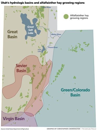
The Reeses are among the state’s 9,300 family hay-growing operations, which consume most of Utah’s water resources. Alfalfa and other types of hay are by far Utah’s most valuable agricultural crop, worth nearly half a billion dollars last year. But that represents just 0.2% of the state’s gross domestic product — on par with revenue generated by amusement parks.
The 2.4 million tons of annual hay the state produces plays a vital role supporting Utah’s agricultural economy, especially ranchers and dairies, but it comes at a price, experts say.
While Utah’s urban dwellers must rein in their notoriously high use of water, the state won’t solve its water woes without serious concessions from the agricultural sector, according to University of Utah economics professor Gabriel Lozada.
Alfalfa and hay account for 68% of the 5.1 million acre-feet of water diverted every year in Utah, Lozada’s research has found. That means it takes 1.38 acre-feet, or about 450,000 gallons, to produce a ton of alfalfa — about as much water as two Utah homes typically use in a year. (An acre-foot is the amount of water it takes to cover one acre of land with one foot of water.)
According to federal data, 29% of Utah’s hay harvest, by value, is exported overseas, with about two-thirds going to China. Up to 1 million acre-feet were used to produce this hay, depending on how many tons this share of the harvest’s value represents, according to Lozada’s calculations.
Could Utah put that water to better use elsewhere without leaving agriculture producers high and dry?
Lozada and others think so, but it would require overhauling Utah’s 19th-century water law so that farmers are rewarded for using less water, and reducing subsidies on the water they are entitled to use.
“Lots of people have warm and generous feelings towards farmers and rural life, but the vast majority of Utahns live in cities and suburbs,” Lozada said. “If you look at what generates the economic vitality of the state, it’s not our farming sector. It’s services, tech, health care, education, retail and transportation.”
That’s not to say that agriculture does not make critical and irreplaceable contributions to Utah’s overall quality of life. Irrigated alfalfa provides numerous environmental and social benefits that are tricky to quantify, but the cost of devoting so much water to a single crop is becoming increasingly and painfully clear as Utah’s water supplies get depleted.
Hidden costs
Scientific studies link Great Salt Lake’s record low water levels to upstream diversions, most of which are feeding agriculture in the Weber, Bear and Provo basins. Saving the lake, which supports $1.3 billion in economic output and internationally significant migratory bird habitat, has become a top priority among state leaders.
Driven also by unrelenting drought, dropping lake levels are not only disrupting robust brine shrimp and mineral industries, but they could also tee up an air quality nightmare for Utah’s urban corridor should exposed lakebed sediments become airborne.
“In economics, by definition, you’re trading off one good thing against another good thing. There are lots of good things about large, prosperous agricultural sectors and stable rural communities,” Lozada says. “But the cost of that, frankly, given the aridification of our climate, is probably horrendous degradation of the quality of life on the Wasatch Front.”
Lozada’s point isn’t to pit urban against rural communities, but rather to encourage reforms so that rural prosperity doesn’t come at the expense of the downstream environment and Utah cities, or vice versa.
Good for the soil
Hay grows on nearly three-fourths of Utah’s 1.1 million acres of irrigated croplands, although that share fluctuates year to year as alfalfa goes in and out of rotation with other crops, like triticale, a wheat hybrid, or corn.
Before laying blame for Utah’s water woes on alfalfa, agronomists say, it’s important to note the pivotal role this high-protein plant plays in rural communities, not to mention its broad environmental benefits.
“It’s a universal feed for cows, horses, goats, anything, and it has the protein that a lot of animals can accept and do really well on,” says fourth-generation Sanpete County rancher Stan Jensen. ” I don’t know of another crop around here that would bring in the yield and the income and serve as many purposes as alfalfa.”
He devotes 100 of his farm’s 500 acres to alfalfa. He estimates 5 feet of water are applied to every inch of land that grows the crop, an amount equal to 160 million gallons.
When managed properly, alfalfa cultivation improves soil and reduces carbon emissions, according to Tony Richards, who heads the Utah Department of Agriculture and Food’s (UDAF) soil health program.
As a perennial legume, alfalfa plants fix nitrogen into the soil and they need to be replanted just once every 5 to 10 years. Accordingly, alfalfa requires far less fertilizer and tilling than most other crops, which lessens its environmental footprint and keeps more carbon and nutrients in the ground.
After five or more years of harvesting from the same alfalfa plants over and over, farmers usually switch to corn or some other crop that draws from the nitrogen from the soil for a few years before replanting the alfalfa. And some farmers grow hay grasses and alfalfa together in ways that maximize yields.
“You can run an alfalfa stand for its whole life and never put any nitrogen [fertilizer] on it,” Richards says. “In a soil health context, alfalfa is a great crop.”
And the plants’ taproots extend up to 15 feet into the ground, which benefits the soil in other ways.
“You have this big root line going all the way down. It’s seeking deeper water so it can go through resiliency with drought,” Larsen says, “but at the same time it is creating a channel that water can infiltrate down through the soil better.”
These deep roots, in other words, enable the ground to absorb water more quickly, which also reduces erosion.
“If we do have a 1-inch rainstorm, are you able to infiltrate all of that inch or is it leaving your field, going somewhere else and taking soil with it as usually is the case?” Richards says. “That infiltration is critical because that water that goes down deep, it also recharges the aquifer. It’s what creates our springs.”
Why alfalfa works for Utah growers
Though it requires lots of water, alfalfa is a good fit with the West’s high-elevation landscapes, according to Ryan Larsen, a Utah State University economics professor.
On Utah’s high-elevation arid steppe, alfalfa is often grown where the land can’t support other crops profitably, particularly in Millard and Iron counties.
“There’s not really much else you could do on that land,” Larsen says. “Alfalfa really is our way of extracting the most value from this land.”
This crop is typically harvested two to four times a year, yielding on average around 3.8 tons per acre. How much depends on availability of water, timing of the harvests and the farmers’ goals, according to rancher Clay Hansen.
“If you cut it earlier, it can create a higher value feed, but there’s less tonnage of product. Or you can wait a little longer and get more tonnage at a lower value,” Hansen says, “or sometimes try to shoot that in the middle where we’re trying to do a little bit of both, so it wouldn’t be uncommon to get four cuttings right here.”
Near the Reeses’ Long Valley farm, Hansen helps manage the alfalfa operations connected to the vast Esplin Livestock Co. operation, which runs cattle on 183,000 acres of public and private land. Hansen’s 200-acre farm grows alfalfa in rotation with other grasses and grains, like sorghum, triticale, oats and barley.
“We’re trying to make sure that we have one or two pieces coming out of alfalfa and going into alfalfa all the time,” Hansen says, “We don’t want our whole farm in one stage because that puts us at really high risk, so we try to be very spread out.”
He aims to harvest 6 tons per acre each year, but how much depends on the weather. A rainstorm can boost a crop or turn a harvest “to junk,” depending on when it hits.
“We can get into that rainy monsoon pattern that we need so badly, but it really ruined a lot of hay,” he says. “Because we couldn’t get it cut at the right time, it had to sit in the field to dry out where it got rained on.”
Like the Esplin operation, the Reeses raise alfalfa to support their livestock operation when rangeland forage is poor or to bridge gaps in their seasonal public lands grazing windows.
“Ideally, we don’t ever want to have to feed our cattle hay. We’re hoping to keep them out grazing the whole year,” Reese says. “But as we’ve seen in the past few years [of drought], we often have to supplement and it has the protein and the nutrients that our animals need to grow.”
Larsen estimates that at least half of Utah’s harvest remains in the state, with the higher quality alfalfas going to the dairies and lower quality going to feed livestock on the range.
“In Millard County, rural Box Elder, rural Iron County, alfalfa production is really what fuels all those communities. If you take that away, I don’t think there’s enough there to support them,” Larsen says. “Our Utah producers would have to have to ship that in from somewhere, which would add additional financial burden, which could lead to them going out of business just because their cost of production would be so high.”
A path forward
Growers can reduce water waste by lining canals and ditches, leveling fields, and investing in pressurized systems, like wheel lines or pivots.
UDAF is helping farmers cover these investments through its water optimization grant program, which covers half the cost of qualifying projects. The state has set aside $70 million in American Rescue Plan Act money for these grants, but that sum will barely put a dent in the need.
Program director Jay Olsen estimates it would take $5 to $7 billion to optimize all 18,000 Utah farms’ use of irrigation water, and the costs keep going up every year.
For Reese, there is only so much she can do to cut water use. Without a reservoir to store the Virgin’s flow, pressurized systems are out of the question for many Long Valley growers.
Two canal companies deliver the water from nearby streams to the Reeses’ five fields spanning 80 acres. The volume of water their company’s shares give them varies from year to year, but Reese doesn’t know exactly how much water floods their fields.
When it’s their turn to irrigate, the ditch gates open for a set period of time then they close. No one is measuring.
“This year, we didn’t have very much water,” Reese says. “A lot of our successful crop production was because of monsoonal rains, not because of what came down the ditch.”
Misaligned incentives
Agricultural producers tend to hold the most senior water rights where they operate and have little reason to use less than their allotted share. In fact, using less puts their water rights at risk under Utah water law.
“You have to prove that you have been using your water, even if you own the water rights,” Reese says. “If you’re not pulling out the water, if you’re not using it, the state will come in and take it to someone else, so most agriculturalists will always use all of their water.”
As growers are not rewarded for conserving water, nor are they penalized for overusing it. This is because growers don’t actually pay for the water they use; they pay a price per share in canal companies, which remains the same regardless of how much water is delivered to their fields. Those payments cover the canals’ debt obligations, operations and upkeep, but not for the water itself.
“What farmers are doing is what’s economically rational given their incentives,” Lozada says. “If you are a farmer, what is your most important input? Water, and it is essentially free, except for the small cost of conveyance and transportation. Surely you would use a whole lot of it. You’d be dumb not to and that’s the situation that we put farmers in.”
(Trent Nelson | The Salt Lake Tribune) Clay Hansen walks through an alfalfa field on his family’s farm in Mt. Carmel on Thursday, Nov. 10, 2022.
Today, legislative reforms are in the works that would enable farmers to temporarily forgo their water or lease it without risking losing their water rights.
“If we put a price on water or we subsidize farmers to not use water, we don’t have to use persuasion anymore. The price system is going to do it,” Lozada says. “If it’s going to profit the farmer more to sell his water to the state than to use it to grow alfalfa, then that’s what he’s going to do.”
But are dry farms what Utahns want? Agriculture’s defenders argue everyone benefits when productive agriculture preserves open space and wildlife habitat near cities. Alfalfa supports farmers in the Heber, Ogden, Weber, Cache and Long valleys who may otherwise sell their land to real estate developers.
More subdivisions would sprawl into Utah’s scenic getaways and the more remote towns would empty out. It’s fair to say rural Utah would look vastly different without alfalfa, and not for the better in Dusty Reese’s view.
“Most of us are hoping that our kids can come back and work on the farm. There’s not a lot of job opportunities in these rural areas, and agriculture is one of them,” Reese says. “When you take away agriculture and you take away the logging, that’s created ghost towns in those areas because there’s no opportunity for people to work in the community and to work with and on the land.”
The Water Desk’s mission is to increase the volume, depth and power of journalism connected to Western water issues. We’re an initiative of the Center for Environmental Journalism at the University of Colorado Boulder. The Water Desk launched in April 2019 with support from the Walton Family Foundation. We maintain a strict editorial firewall between our funders and our journalism.
The Colorado Department of Public Health and Environment. Credit: Jerd Smith
By Jerd Smith
Colorado regulators, after years of study, negotiations and testing, approved a new rule that clears the way for drinking treated wastewater this week, one of only a handful of states in the country to do so.
The action came in a unanimous vote of the Colorado Water Quality Control Commission Oct. 11.
Direct potable reuse (DPR) involves sophisticated filtering and disinfection of sewage water for drinking water purposes, with no environmental buffer, such as a wetland or river, between the wastewater treatment plant and drinking water treatment plant. That water is then sent out through the city’s drinking water system.
Colorado joins Ohio, South Carolina and New Mexico in setting up a regulated DPR system, with California, Florida and Arizona working to develop a similar regulatory scheme, according to Laura Belanger, a water reuse specialist and policy advisor at Western Resource Advocates.
Ron Falco, safe drinking water program manager for the Colorado Department of Public Health and Environment (CDPHE), said the new regulation would provide communities across the state important access to a new, safe source of drinking water, a critical factor in a water-short state.
“This is going to be a need in Colorado and we want to be prepared,” he said. “Can DPR be done safely? Our answer to that is yes.”
Aurora has had a reuse system in place for more than a decade that also uses treated wastewater. But Aurora’s water is treated and released from the wastewater treatment plant into the South Platte River, where it flows through the river’s alluvial aquifer, before Aurora pumps it out through groundwater wells. Aurora then mixes it with raw mountain water before treating it and distributing it to customers. That practice is known as indirect potable reuse — there’s an environmental buffer between the wastewater plant and the drinking water plant, in Aurora’s case, that’s the river. Indirect potable reuse is used by several big cities nationwide, including San Diego.
Graphic by Chas Chamberlin, Source: Western Resource Advocates
Under Colorado’s new regulation, water providers will be required to show they have the technical, managerial and financial resources needed to successfully treat wastewater.
Communities will also be required to show how they will remove contaminants in their watersheds before the water reaches rivers and streams.
Wastewater intended for drinking will require extensive disinfection and filtration, among other techniques, all of which are intended to eliminate pathogens like viruses and bacteria, and remove drugs and chemicals to safe and/or non-detectable levels, according to CDPHE.
And any community that seeks to add treated wastewater to its drinking water system will have to set up extensive public communication programs to show the public its process and to help educate residents about this new water source.
Communities will also have to collect a year’s worth of wastewater samples and prove that they can be successfully treated to meet the new standards.
Western Resource Advocates’ Belanger, who has long advocated for the use of DPR, said the approval has been a long time coming and is cause for celebration.
“We believe DPR is a very important water supply for our communities now and into the future. We feel [this new regulation] is robust and protective of public health.”
But key to tapping the new water source will be helping the public get over the “ick factor,” officials said.
Jason Rogers, vice chair of the Water Quality Control Commission who is also Commerce City’s director of community development, said public outreach should be carefully monitored to ensure it is actually reaching people in all communities and that it is being well-received.
“When thinking about that public meeting, where does it occur? People in some of these communities may have a high reliance on multi-modal transportation, it may not allow for that meaningful engagement,” Rogers said. “And if it isn’t being well received, we need to have them go out and do more public engagement.”
With a mega drought continuing to grip the Colorado River Basin and other Western regions, Colorado’s multi-year process to develop a sturdy new drinking water regulation drew widespread attention, said Tyson Ingels, the head drinking water engineer at the state’s Water Quality Control Division.
Ingels said Utah and Arizona participated in Colorado’s work sessions, demonstrating the interest in what could become an important new water source in the West. Arizona is just now kicking off its own rulemaking process, Ingels said, and Utah, while not yet regulating DPR, has seen a handful of communities proposing to use DPR.
Colorado’s rulemaking process, which dates back to 2015, was at times fractious, with water providers and wastewater operators concerned that the proposed regulation would interfere with what they’re doing already and could add burdensome costs to efforts to develop new water sources.
Ingels said the addition of a third-party facilitator was essential to resolving everyone’s concerns.
Jeni Arndt, a former lawmaker who also serves on the water quality commission, said finalizing the groundbreaking new regulation signaled an important step forward in navigating difficult public policy issues. [Editor’s note: Arndt is a former board member of Water Education Colorado, which sponsors Fresh Water News.]
“Gone are the days when we were struggling to come to agreement,” Arndt said. “I’m very excited to move forward into a new era.”
On Tuesday, several water utilities spoke in favor of the new regulation, including the Cherokee Metropolitan District, Castle Rock, and the City of Aurora.
Matt Benak, Castle Rock’s water resources manager, said the regulation will give his town the certainty it needs to move forward developing new water supplies. “DPR is a critical tool for sustainable water resources. Creating this regulation will allow water providers like us to plan and to potentially implement DPR,” he said.
Tuesday’s approval was contingent on fixing minor clerical errors in the regulation. Commissioners will give final formal approval of the regulation at its November meeting.
Jerd Smith is editor of Fresh Water News. She can be reached at 720-398-6474, via email at jerd@wateredco.org or @jerd_smith.
Fresh Water News is an independent, nonpartisan news initiative of Water Education Colorado. WEco is funded by multiple donors. Our editorial policy and donor list can be viewed at wateredco.org.
The Water Desk’s mission is to increase the volume, depth and power of journalism connected to Western water issues. We’re an initiative of the Center for Environmental Journalism at the University of Colorado Boulder. The Water Desk launched in April 2019 with support from the Walton Family Foundation. We maintain a strict editorial firewall between our funders and our journalism.
The All-American Canal conveys water from the Colorado River to the Imperial Valley in Southern California. The Imperial Irrigation District is the largest user of Colorado River water. CREDIT: HEATHER SACKETT/ASPEN JOURNALISM
Staff and board members from the Glenwood Springs-based Colorado River Water Conservation District, along with other water managers from across western Colorado, this month visited the lower basin states — Nevada, Arizona and California — on what they called a fact-finding trip.
The tour took participants by bus from Las Vegas though the green alfalfa fields of the Fort Mohave Indian Reservation, past the big diversions serving the Central Arizona Project and Metropolitan Water District of Southern California, and to the hot, below-sea-level agricultural expanse of the biggest water user on the river: the Imperial Irrigation District. Among the about 50 participants on the three-day tour were Kathy Chandler-Henry and Steve Beckley, River District board representatives from Eagle and Garfield counties. Pitkin County representative John Ely did not attend.
The River District’s mission is to protect, conserve, use and develop the waters within its 15-county area of western Colorado and to safeguard the water to which the state is entitled.
With the nation’s two largest reservoirs — Lake Powell and Lake Mead, which store Colorado River water — at record-low levels that threaten hydropower production, and calls for conservation coming from the federal government, it’s more important than ever for western Colorado residents to understand how water is used in the lower basin, said River District general manager Andy Mueller.
“We have to be able to understand (lower basin) interests and their needs so that we can find ways to meet their interests while protecting our own,” he said. “There’s a system at risk of collapse, and we are an integral part of that.”
The Metropolitan Water District of Southern California diverts water from Lake Havasu on the Colorado River at the Whitsett Pumping Plant. CREDIT: HEATHER SACKETT/ASPEN JOURNALISM
One in 17 people
An often-repeated fact about the Colorado River is that it provides water to 40 million people in the Southwest. But perhaps an even more salient statistic is that 1 in 17 people in the U.S. — about 19 million — get their water from the Metropolitan Water District of Southern California. About half of that comes from the Colorado River.
Since 1941, MWD’s Whitsett Pumping Plant has taken water from Lake Havasu and pumped it into the Colorado River Aqueduct, where it then travels 242 miles to urban Southern California. The water district spans 26 municipalities and six counties.
The future of providing enough water to all these urban customers may be something called direct potable reuse — MWD calls it raw-water augmentation — which would allow them to recycle wastewater into drinking water instead of discharging it into the ocean. MWD is testing this concept with its Pure Water Southern California demonstration facility, located in Carson, Calif., which was the last stop on the tour.
Direct potable reuse takes sewage, treats it using sophisticated — and expensive — filtering and disinfection techniques and returns it to taps as drinking water without first diluting it in a larger body of water. Last month, Colorado’s Water Quality Control Commission gave preliminary approval to regulate direct potable reuse.
MWD is working toward using the recycled water for industrial purposes and groundwater recharge, and it eventually hopes to deliver it to residents’ taps. The water provider could have a preliminary portion of the project online by 2028. This new supply of recycled water could meet about 10% of MWD’s demands, according to Rupam Soni, MWD’s community-relations team manager.
“It provides us with so much operational flexibility and water reliability because this supply is available to us rain or shine, it’s climate resilient, and that’s really important to us right now, with climate change and the challenges it’s imposed on our imported supplies,” Soni said.
Rupam Soni, MWD’s community-relations team manager, gives a tour of MWD’s Pure Water Southern California demonstration facility. MWD is hoping to soon use recycled wastewater, known as direct potable reuse, to augment its supplies from the Colorado River. CREDIT: HEATHER SACKETT/ASPEN JOURNALISM
Forage crops are No. 1
Although it’s true that much of the country’s winter produce, especially lettuce, comes from lower basin farmers, the No. 1 thing grown with Colorado River water is forage crops: alfalfa and different types of grasses to feed livestock.
The Imperial Irrigation District is entitled to 3.1 million acre-feet a year of Colorado River water, and according to most recent data provided by Public Information Officer Robert Schettler, IID uses about 2.7 maf with the balance being transferred to other lower basin consumers. By comparison, the entire upper basin (Colorado, Utah, New Mexico and Wyoming) uses between 3.5 and 4.5 million acre-feet per year from the Colorado River. An acre-foot is the amount of water needed to cover an acre to a depth of one foot and is enough to supply one or two families for a year.
IID’s No. 1 crop is alfalfa and represents almost 31% of the acres grown. Bermuda grass and Sudan grass are second and third, respectively. These top three crops account for about 56% of the acres grown in IID, according to the district’s 2021 annual report.
Forage crops comprise the majority of what is grown in the upper basin, too. But growers in Colorado’s high-elevation valleys can expect about two cuttings a year, while much of the lower basin grows hay year-round, getting seven to nine cuttings. That means switching to less-thirsty forage crops in the lower basin could have a greater impact on the amount of water used.
In Colorado, some irrigators are experimenting with growing forage crops that use less water in an effort to adapt to a hotter, drier future.
Kremmling rancher Paul Bruchez, a representative on the Colorado Water Conservation Board, is trying out test plots on his family’s ranch. He’s growing sainfoin, a legume with a nutritional value similar to that of alfalfa. Bruchez, a participant on the tour, said some lower basin water managers and growers have expressed interest in meeting with him to learn more about growing less-thirsty crops.
Bruchez stressed that switching forage crops in the upper basin is not about propping up Powell and Mead with water saved from agriculture, especially since there isn’t currently a demand-management program in place to account for that water savings. It’s about survival.
“People just don’t have enough water to irrigate the way they used to irrigate,” he said. “They are just trying to make a living and stretch their water to go further.”
A tractor sits in the fields of the Imperial Irrigation District in Southern California. The district is the largest water user on the Colorado River. CREDIT: HEATHER SACKETT/ASPEN JOURNALISM
Upper basin bears brunt of climate-change impacts on streamflows
Over the past two decades, the Colorado River has lost nearly 20% of its flows. Part of that is because of the ongoing drought, the worst in 1,200 years, which means less precipitation. But according to researchers, about one-third of that loss can be attributed to hotter temperatures driven by climate change. Decreased river flows mean that less water ends up in Lake Powell and Lake Mead.
These reduced streamflows in the upper basin mean water users may have to adapt their operations because less water is available to them. If there’s less water in the stream, junior users may get cut off and senior users may not be able to take their full amount. Streamflows can be particularly inadequate during the late-summer and early-fall irrigation season and some water users are at the mercy of dry local conditions.
Upper basin water managers like to point out that this isn’t the case in the lower basin. Although western Colorado has thousands of small-scale water users diverting from dwindling rivers, the lower basin has just a handful of large-scale water users who have the benefit of two huge upstream storage buckets that release the water exactly when it’s needed.
“Our farmers in particular live within that hydrology in flux and we have learned how to adapt to climate change,” Mueller said. “In the lower basin, their agriculture and outdoor landscaping are absorbing more water because of the hotter temperatures, so they just call for more from the reservoirs.”
The Las Vegas wash is a 12-mile-long channel that returns the valley’s excess water to Lake Mead. The Southern Nevada Water Authority has recommended that lower basin contractors be charged for evaporative losses, something upper basin water managers have been saying for years. CREDIT: HEATHER SACKETT/ASPEN JOURNALISM
Evaporation loss not accounted for in lower basin
The thing about building giant reservoirs in the desert is that a portion of the water evaporates into the hot, dry air. In the upper basin, these evaporative losses from the reservoirs of the Colorado River Storage Project are accounted for and charged as part of the consumptive use to each state depending on their allocation of water.
For example, as laid out in the 1948 Upper Colorado River Compact, Colorado’s allocation of upper basin water is 51.75%. Therefore, the state takes 51.75% of the evaporative losses for Blue Mesa, Flaming Gorge and Lake Powell. Such is not the case in the lower basin, where evaporative losses in reservoirs remain unaccounted for.
Upper basin water managers have long said this accounting is unfair and enables overuse in the lower basin.
“We are asking for (the lower basin) to be treated the same way we are so the system and the playing field is even,” Mueller said. “Once we are on an even playing table, then we can address the way we work in the future, but it’s really hard to do that when the rules they play by down here enable so much more water use than what we have in the upper basin.”
The upper basin may finally be making progress on this point, for at least one lower basin water provider has taken up the rallying cry. In an August letter to federal officials, Southern Nevada Water Authority’s John Entsminger recommended that each lower basin contractor be charged for evaporation losses so that “the lower basin can reduce its reliance upon excess water from the upper basin to balance reservoirs.”
A subsequent study by SNWA found about 1.5 million acre-feet in evaporation and transit losses each year downstream of Lee Ferry, the dividing line between the upper and lower basins that is just downstream of Lake Powell’s Glen Canyon Dam.
“We divorced the water use in the lower basin from the hydrology,” Mueller said. “When you have 50 years of reliable water supply, you don’t think about the fragility of the natural system that’s providing that water.”
Editor’s note: This story has been changed to reflect that while IID’s annual entitlement of Colorado River water is 3.1 million acre-feet of water, the district uses about 2.7 million acre-feet.
The Water Desk’s mission is to increase the volume, depth and power of journalism connected to Western water issues. We’re an initiative of the Center for Environmental Journalism at the University of Colorado Boulder. The Water Desk launched in April 2019 with support from the Walton Family Foundation. We maintain a strict editorial firewall between our funders and our journalism.
Colorado River on the West Slope. Credit: Kevin Maloney
By Jerd Smith
Coloradans want the state’s top water road map to mandate faster action, be more accountable, require equitable drought responses between the East and West slopes, and include the crisis on the rapidly drying Colorado River in its estimates of future water shortages.
More than 1,300 individuals and agencies submitted public comments on the draft update to the Colorado Water Plan, according to Russ Sands, chief of water supply planning for the Colorado Water Conservation Board (CWCB). Read the comments here.
The public comment period ended Sept. 30. The CWCB is scheduled to finalize revisions to the plan in January 2023. [Editor’s note: The CWCB is a funder of Water Education Colorado, which is a sponsor of Fresh Water News.]
Commenters, including major water utilities, environmental groups, ranchers and farmers, and city and county officials, have asked for numerous changes.
“The plan lacks the language of urgency throughout. It should emphasize the scarcity of time and water to address the life-or-death reality of the drought and the climate crisis that the state of Colorado is facing,” Hispanics Enjoying Camping, Hunting and the Outdoors wrote in their submitted comments.
The CWCB is responsible for drafting and updating the plan and supporting its implementation. Championed by U.S. Senator John Hickenlooper when he served as governor, the state’s first water plan was approved in 2015 after years of public meetings and data gathering.
At the time, it was hailed as a breakthrough in grassroots water planning in the West because of its comprehensive effort to engage the public, analyze existing water use, future shortages, and potential solutions.
Since then, the CWCB has awarded more than $500 million in grants and loans to help communities develop water management plans, projects and other options locals believe are necessary to ensure their water futures.
But the plan was politically difficult to finalize even then because of conflicts between water utilities and environmentalists, pro-dam and anti-dam interests, and agricultural and urban water conflicts.
Regardless, water users across the state say that the water plan has spurred more cooperation than has ever existed before, with public roundtables in each of the state’s eight river basins making decisions and sharing information with one another, using the water plan as a roadmap.
Now, as the CWCB updates the plan and a 22-year megadrought drains the Colorado River system, pressure is building to act quickly.
For example, in their comments several individuals and agencies asked that the updated plan include more measurable goals with deadlines to improve accountability in addressing the state’s looming water shortages and environmental issues.
Business for Water Stewardship (BWS), a nonprofit that seeks to connect corporate funders with environmental initiatives, was among them.
“The water plan lacks specifics and accountability,” BWS wrote. “The plan should include metrics on conservation and storage and guidelines on how we balance competing needs. These metrics are necessary to measure progress on the plan’s goals and objectives.”
Forecasts show water supplies will not keep pace with demand by 2050 for agricultural (Ag) or municipal and industrial (M & I) needs if Colorado does not find new approaches. Source: 2019 Analysis and Technical Update to the Colorado Water Plan. Credit: Chas Chamberlin
Major water diversions between West Slope river basins and Front Range cities were also a topic of concern.
Roughly 80% of the state’s water supplies originate in West Slope mountain snowpacks, while much of that water is moved to the thirsty Front Range in pipelines and canals known as transmountain diversions or TMDs.
The Colorado River District and other West Slope interests want the state to require that when the West Slope is facing ultra-dry conditions and forced to deal with water restrictions and cutbacks, as it often is just because of its geography, urban cities who are using that West Slope water, live under the same rules. The district represents 15 West Slope counties and is responsible for managing the Colorado River within state boundaries.
For years, West Slope communities whose rivers have been subject to severe drying due to drought and climate change, have complained about urban indifference to their plight.
This year, for instance, some West Slope river basins saw runoff that was well below average, while many Front Range communities, thanks to big reservoirs and better runoff from local rivers, saw normal conditions. There were water restrictions to the west, but few if any to the east.
“The river district recommends a stronger stance towards water conservation and a recommendation that communities reliant on TMD supplies tailor conservation needs when any watershed with their source water is undergoing drought conditions. This is particularly important when the end-use basin is undergoing less severe drought conditions than their TMD source watersheds,” the river district wrote.
The CWCB’s Sands said the state has limited ability to act on a request like this one, given that it has no statewide authority to impose drought restrictions.
Still another major topic of concern among several commenters is the ongoing crisis on the Colorado River. The river begins in the Never Summer Mountains in Rocky Mountain National Park and by the time it makes its way west to the Utah state line, it has generated the majority of the entire seven-state river system’s water.
With the river in crisis and lakes Powell and Mead at historic low levels, Arizona, California and Nevada have begun taking cutbacks, a situation that eventually could occur in Colorado, where major metropolitan areas rely on the river for roughly 50% of their supplies.
And while the draft plan acknowledges the impact of climate change and uncertainties regarding future supplies, commenters say it should include more specifics on how the crisis could affect Colorado’s own water future.
The Sierra Club called release of the draft plan premature, because it did not adequately address the Colorado River crisis. Larimer County, the City of Fort Collins and the Colorado Agricultural Water Alliance, also asked that the draft plan include more specifics on the river’s dicey future.
“Adding the Colorado River crisis” to Colorado’s already well known water problems, “is like adding an overactive bull into an already somewhat ramshackle china shop,” the Sierra Club wrote. “Having the draft plan revision out at this time is premature given the likely need to stop about 30% of Colorado’s present use of Colorado River water.”
Here too, Sands said, the plan is focused on intrastate water issues and isn’t the state’s primary vehicle for dealing with the Colorado River crisis and protecting the state’s water interests outside state boundaries.
The CWCB is scheduled to address which public requests for additions to the water plan will be included in the final draft at its November meeting, Sands said.
In the meantime, several commenters expressed hope that the revised water plan will create the energy and vision the state needs to address its complicated water future.
Said Colorado Springs Utilities, “The water plan is a formative document that outlines meaningful goals and actions for addressing the water supply gap in a time of increasing water scarcity. It will take political courage to ensure this plan has the impact Colorado requires.”
Jerd Smith is editor of Fresh Water News. She can be reached at 720-398-6474, via email at jerd@wateredco.org or @jerd_smith.
Fresh Water News is an independent, nonpartisan news initiative of Water Education Colorado. WEco is funded by multiple donors. Our editorial policy and donor list can be viewed at wateredco.org.
Clarification: The article has updated to reflect that the water plan is not the CWCB’s primary tool for addressing the Colorado River Water Crisis.
The Water Desk’s mission is to increase the volume, depth and power of journalism connected to Western water issues. We’re an initiative of the Center for Environmental Journalism at the University of Colorado Boulder. The Water Desk launched in April 2019 with support from the Walton Family Foundation. We maintain a strict editorial firewall between our funders and our journalism.