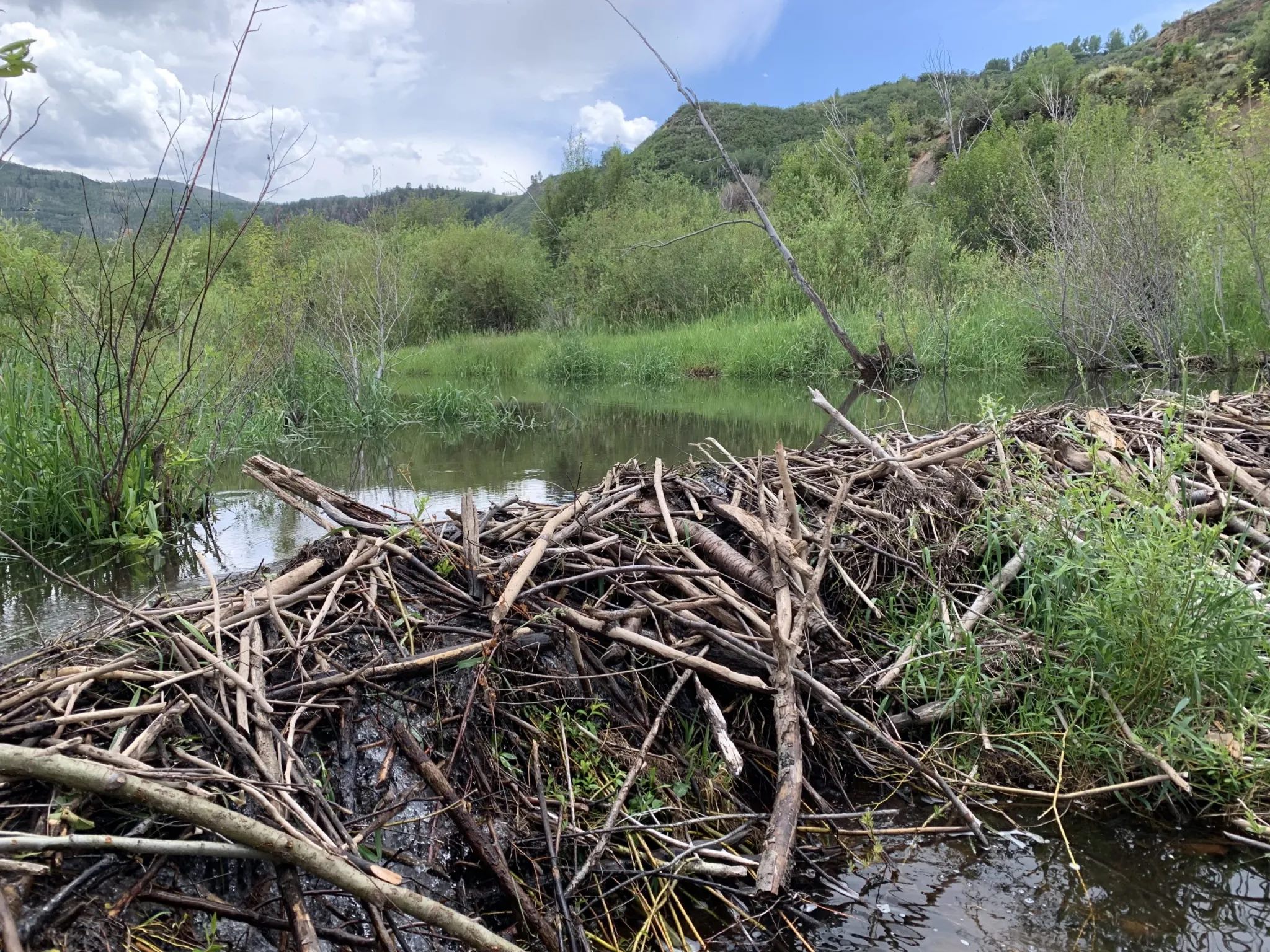
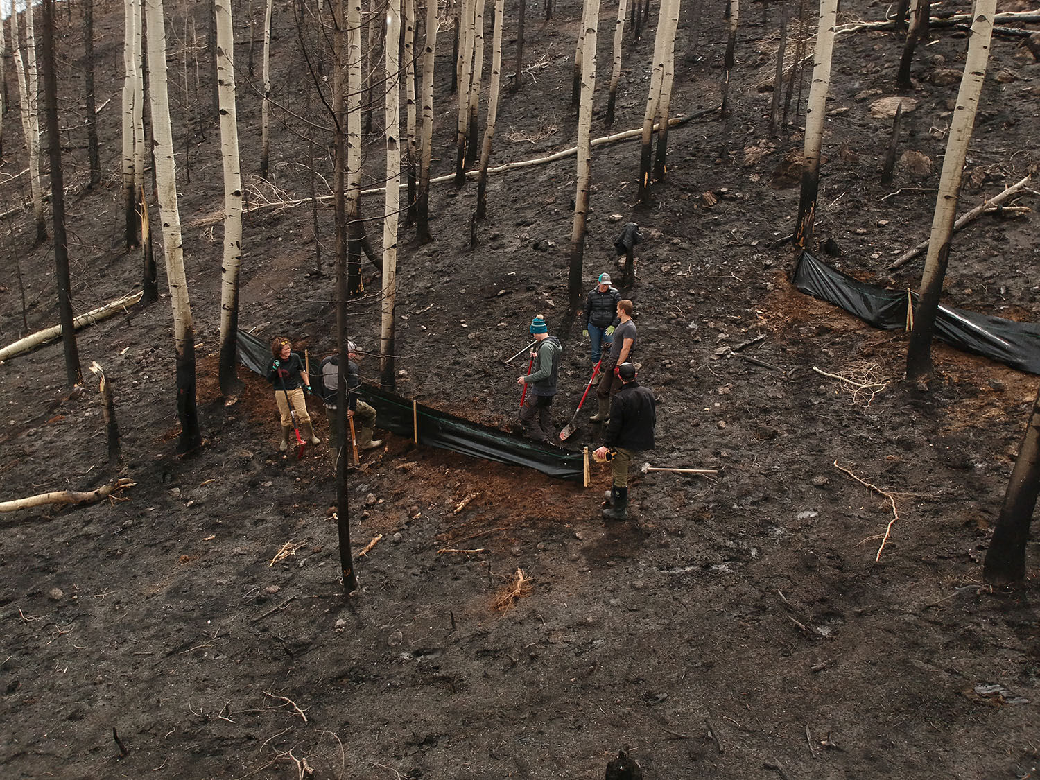
Beavers have constructed a network of dams and lodges on this Woody Creek property. Pitkin County is betting big on beavers, funding projects that may eventually reintroduce the animals to suitable habitat on public lands. CREDIT: HEATHER SACKETT/ASPEN JOURNALISM
During the summer of 2020, Woody Creek landowner Jennifer Craig noticed that beavers had taken up residence on her property, building a dam across the channel and creating a pool.
The network of dams, pools and lodges has continued to grow over the past few seasons, creating a lush, muddy wetland thick with willows. And despite what Craig characterized as complaints about flooded land from downstream neighbors and calls for her to clear out the beaver handiwork she says the beavers are beneficial because they keep water on the landscape.
“As an upstream landowner, the best thing I can do is nothing,” she said. “Flooding from a beaver dam is natural, but people don’t like the chaos. Beavers provide habitat for so many other creatures, and they are keeping water in that whole corridor down there.”
Pitkin County is hoping that other landowners see things the way Craig does as it makes beavers a top priority, funding measures that may eventually restore North America’s largest rodent to areas it once lived in the Roaring Fork watershed.
Prized among early trappers for their fur that made fashionable hats, beavers were also seen as a nuisance to farmers and ranchers — perspectives used to justify killing them. But there has been a growing recognition over the past few years that beavers play a crucial role in the health of ecosystems. By building dams that pool water, the engineers of the forest can transform channelized streams into sprawling, soggy floodplains that recharge groundwater, create habitat for other species, improve water quality, and create areas resistant to wildfires and climate change.
The growing popularity of the animal caught the attention of Healthy Rivers board members, a group whose mission includes improving water quality and quantity. They are hoping to teach landowners how to coexist peacefully with beavers, correct beaver misconceptions and maybe even reintroduce them onto carefully chosen areas of the watershed. The Pitkin County Healthy Rivers board has spent just over $70,000 to date, with another $50,000 planned toward bringing back beavers, according to Healthy Rivers staff.
“They are so important for our environment and, in particular, our water environments,” said Wendy Huber, chair of the Healthy Rivers board. “How do we shift people’s perception of them from being destructive rodents to being our partners in protecting the environment?”
Woody Creek landowner Jennifer Craig points out the network of beaver dams, ponds and lodges on her property. She first noticed the animals had moved in during the summer of 2020 and the beaver dam complex has been growing each season. CREDIT: HEATHER SACKETT/ASPEN JOURNALISM
Forest Service inventory
Healthy Rivers has, so far, come up with two ways to do that.
One is a public-awareness campaign called Bring Back Beavers that features cute yet edgy beaver characters and catchphrases (“It’s About Dam Time,” for example), with plans to put the slogans on T-shirts and stickers. A new website presents beaver facts (their teeth never stop growing) and busts beaver myths (they don’t eat fish).
The other part of the strategy is to fund a program with the U.S. Forest Service for a beaver survey that aims to document more than 200 randomly selected riparian sites on public land in the headwaters over two years to find where beavers are thriving and identify locations where they could be successfully relocated in the future. Healthy Rivers has spent $50,000 on the project, which paid for two Forest Service technicians to carry out the work and has earmarked another $50,000 for next season.
Clay Ramey, a fisheries biologist with White River National Forest, is leading the effort, along with two technicians in the field, Samantha Alford and Stephanie Lewis, who are spending the summer chasing beavers. Ramey said that for a watershed-scale project such as this, it is important to analyze data collected from around the entire region, not just in places where beavers live.
“Beavers come and go, so measuring known sites is not helpful,” he said. “We are in the habitat business, so we want to know the big-picture questions like where do we have beavers, where do we not have beavers and what is the habitat like at the places where we do have beavers and what is the habitat like at the places where we do not have beavers.”
To that end, Alford and Lewis have been heading into sometimes-remote sites on streams throughout the watershed — North Thompson Creek, Fryingpan River, Conundrum Creek, Hunter Creek, Snowmass Creek and others — to measure the width of waterways, the slope of streams, the types of vegetation present and any signs of beaver activity, past or present, such as dams, lodges or chewed sticks.
Beavers generally like slow-moving streams that are not too steep and have plenty of nearby willows, aspens, cottonwoods and alders, which they can use for food and building materials.
“We know slope is relevant to where a beaver can prosper,” Ramey said. “Aspen, cottonwood, alder — a site that has none of those is not a place a beaver is going to do well because it doesn’t have any food.”
Ramey hopes the information collected by the inventory project will be incorporated into revisions for the updated forest-management plan, which is in progress.
Samantha Alford, right, and Stephanie Lewis, technicians with the U.S. Forest Service, measure the slope and width of Conundrum Creek. Pitkin County has spent $50,000 on this summer’s beaver habitat survey and has earmarked another $50,000 for next season. CREDIT: HEATHER SACKETT/ASPEN JOURNALISM
Beaver relocation
Tom Cardamone, executive director of the Watershed Biodiversity Initiative and former longtime director of the Aspen Center for Environmental Studies, is one of several beaver boosters who have been quietly meeting over the past few months, plotting how to communicate with the public about beaver restoration.
With permission from Colorado Parks & Wildlife, Cardamone has relocated nuisance beavers on Nicholson Creek, which is a tributary of Capitol Creek, but he realized that a more formal protocol will be needed if rehoming them becomes more frequent. An eventual outcome of Pitkin County’s campaign may be relocating troublemaking beavers on private land to sites identified by the Forest Service survey as prime habitat on public land.
“You need to catch a whole group and move them to get them to stick,” Cardamone said. “It takes a few days to catch them and you have to hold them someplace that’s protected and secure, so no predators. You have to clean them and make sure they are healthy and then move them all as a group. That’s a bit of a lift.”
But there may be a looming legal question about new ponds created by relocated beavers. This year, Colorado lawmakers rejected a version of a bill that would have made it easier for environmental groups to do stream-restoration projects that mimic beaver activities because of potential unknown impacts to downstream water rights holders. Engineers from the Division of Water Resources last year told groups proposing projects on Eagle County Open Space that would have included beaver dam analogues that they must get an augmentation plan — which are costly, require the work of attorneys and engineers, and involve a lengthy water court process — to replace the water lost to evaporation by the creation of small ponds.
Could the same thing happen if the ponds were created by actual beavers on Forest Service land?
“We have not seen any indication that there’s a substantial legal concern,” said Pitkin County Assistant Attorney Laura Makar.
That’s good news for Huber, who has such an affection for the creatures that she once tried but failed to carry a favorite stick she found on a Montana fishing trip — its ends chewed and denuded of bark by beaver incisors — through airport security.
“Let’s bring them back,” she said. “They were here first. It’s a no-brainer.”
Aspen Journalism is a nonprofit, investigative news organization covering water, environment, social justice and more. Visit http://aspenjournalism.org. Aspen Journalism is supported by a grant from the Pitkin County Healthy Community Fund. Jennifer Craig is the daughter of Carol Craig, a long-time Aspen Journalism supporter.
The Water Desk’s mission is to increase the volume, depth and power of journalism connected to Western water issues. We’re an initiative of the Center for Environmental Journalism at the University of Colorado Boulder.
A marina at Blue Mesa Reservoir where boaters are returning in droves, thanks to improved water levels. Photo credit: National Park Service/Matt Johnson
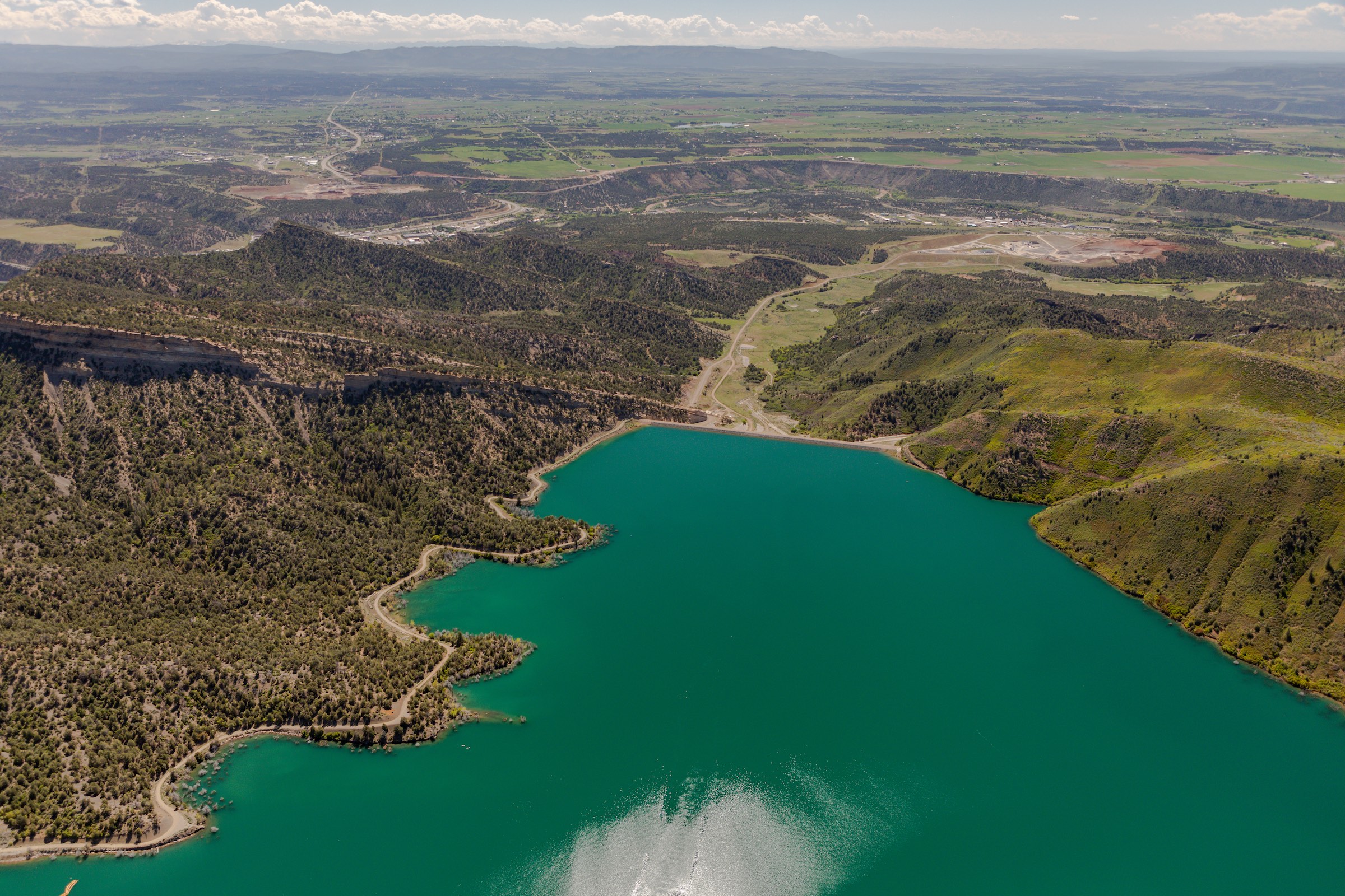
Southwestern Colorado’s Blue Mesa Reservoir, drained by years of drought and a major release of water designed to aid a plummeting Lake Powell, is experiencing a rebirth this summer and could fully fill by the end of the recreation season.
“The water has been shooting up,” says Eric Loken, who manages the two marinas on the reservoir.
Blue Mesa is one of four federal reservoirs in the Upper Colorado River Basin designed to hold water to help the Upper Basin states—Colorado, New Mexico, Utah and Wyoming—meet legal obligations to send water downstream to Arizona, California and Nevada. The other Upper Basin reservoirs include Utah’s Flaming Gorge, New Mexico’s Navajo, and Utah and Arizona’s Lake Powell.
In 2021, already partially drained by years of drought and thin snowpacks, millions of gallons of water were sent from Blue Mesa downstream to Lake Powell in an effort to bolster that reservoir and keep hydropower-generating turbines operating.
Even more water was released upstream that year, from Flaming Gorge.
But this year, thanks to abundant snows and a cool, rainy spring across the region, Blue Mesa and Flaming Gorge are in recovery mode, according to Alex Pivarnik, a U.S. Bureau of Reclamation hydrologist.
“Flaming Gorge is on the up. Blue Mesa is on the up. Powell is going to be increasing as well,” Pivarnik says.
Two years ago the picture was much different. Marina operators were scrambling to move docks and gasoline tanks as reservoir levels plummeted.
Blue Mesa is Colorado’s largest reservoir, holding more than 940,000 acre-feet of water when it is full. An acre-foot of water equals nearly 326,000 gallons and is enough to serve two to four urban households for one year. Though reservoir levels fluctuate, depending on releases to downstream water users, Blue Mesa held 747,000 acre-feet of water as of July 25, meaning it was nearly 80% full.
Last year, with little recovery in sight, Loken was forced to close the Elk Creek Marina, the largest on Blue Mesa. He, and the thousands of boaters, campers and anglers who visit the giant watering hole, worried that the future was so bleak that the reservoir might not recover.
“There was some concern that it would never refill,” Loken says. “There was concern we might have to send everything we had downstream [to Powell].
“But this year we are way up. It’s a lake again. It’s quite nice,” he says.
And for this year, at least, as the water levels rise, federal officials say there will be no need for additional emergency releases under a special drought plan approved in 2019, giving everyone some room to breathe and enjoy the giant pool.
“There is no plan to do additional drought response [releases] in 2023,” Pivarnik says. “But we don’t want people to sit there and think one good year of runoff and snowpack gets you out of 20 years of drought. We still have to manage for a drier future.”
This article first appeared in Water Education Colorado’s Summer 2023 issue of Headwaters Magazine.
Jerd Smith is editor of Fresh Water News. She can be reached at 720-398-6474, via email at jerd@wateredco.org or @jerd_smith.
Fresh Water News is an independent, nonpartisan news initiative of Water Education Colorado. WEco is funded by numerous donors. Our editorial policy and donor list can be viewed at wateredco.org.
The Water Desk’s mission is to increase the volume, depth and power of journalism connected to Western water issues. We’re an initiative of the Center for Environmental Journalism at the University of Colorado Boulder.
The Salton Sea is a 316-square mile, shallow glaze of water in Southern California that has been receding in recent years. Scientists believe the toxic dust kicked up from the exposed lakebed is contributing to respiratory disease in the region. | All photos by KITRA CAHANA for UNDARK
Water Desk Grantee Publication
This story was supported by the Water Desk’s grants program.
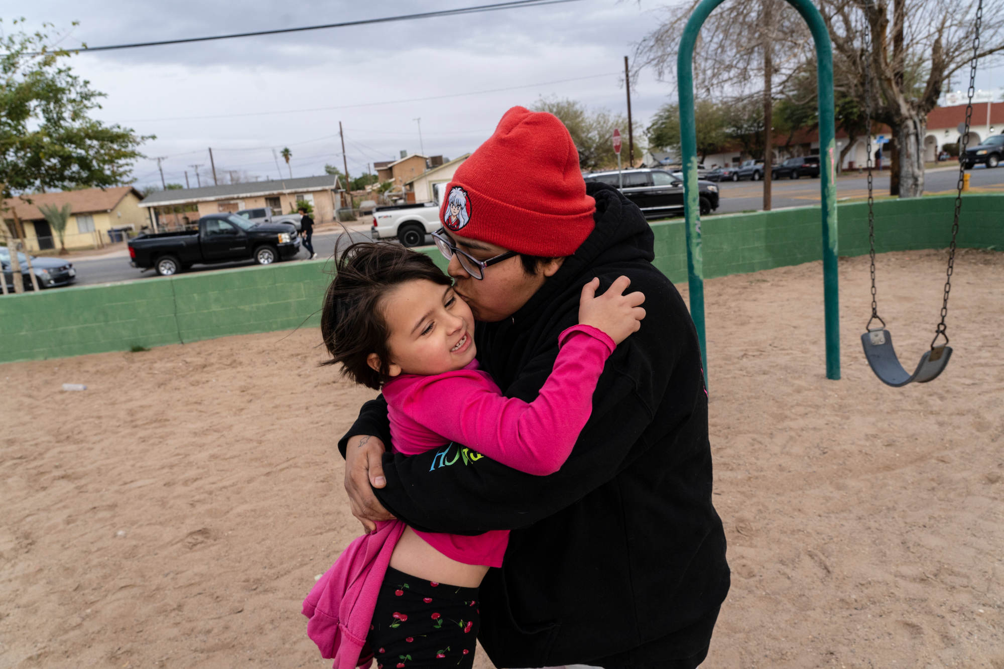
On the afternoon of Oct. 6, 2022, a massive dust storm rose in the drought-parched Sonoran Desert just southeast of California’s Salton Sea. Wind, gusting at more than 60 miles per hour, whipped the desert floor into a vaulting curtain of sediment that swept north across the Imperial Valley, engulfing low-slung agricultural towns like El Centro and Brawley in a mantle of suffocating dust. The storm knocked out power, downed trees, and shrouded the region in an eerie amber haze. The Environmental Protection Agency’s Air Quality Index, which considers scores above 150 unhealthy, and those above 300 hazardous, spiked to 659 at a monitoring station on the western shore of the Salton Sea. And as the avalanche of dust bore down, Trianna Morales, a 31-year-old baker at the local Vons supermarket in Brawley, looked on with dread. “Oh my God,” Morales thought. “We’re gonna get sick.”
Trianna Morales and their daughter, Luna, at a park in Brawley, California. Last fall, a massive dust storm hit their town, sending Luna to the ER for breathing issues for the third or fourth time in a year. Morales, their two young children, and their fiancé all have severe asthma. In Brawley and other communities near the Salton Sea, rates of respiratory disease are sky high.
Morales and their two children, 6-year-old Luna and 3-year-old Frederick, as well as Morales’ fiancé, Cyrus Ramirez, all suffer from severe asthma. Inhalers, nebulizers, and packages of various medications crowd the countertops of their apartment, while a homemade air purifier — built from a box fan and furnace filters — usually whirs away in the corner of the living room. These defenses, however, too often prove insufficient against the dust storms that now blow through the region with increasing frequency. During these events, there is little the family can do besides wait anxiously to see whose attack will be the gravest. This time, it was Luna’s.
The child began coughing soon after the storm arrived, and in the following days her symptoms worsened. When she started experiencing asthmatic retractions — a type of severely labored breathing that caused her chest to cave inward — Morales rushed her to the hospital. There, doctors administered steroids to open Luna’s airways. She soon recovered, and the family was allowed to return home. For Morales, the episode was frightening and demoralizing — but also depressingly familiar. It was Luna’s third or fourth visit to the ER for breathing issues in the last year alone. Frederick had also made several trips. “I just feel so bad for them,” said Morales. “They’re never going to get away from this.”
Morales and their fiancé, Cyrus Ramirez, administer nebulizer treatments to Luna and Frederick in January 2023. As dust storms increasingly roll through the region, the protection the family has against asthma attacks is too often insufficient.
Morales attributes their family’s breathing problems to the Salton Sea, a strange and troubled body of water 17 miles by car to the north. The largest lake by surface area in California, the Salton Sea is a 316-square mile, exceedingly shallow glaze of water that stretches from the Imperial Valley in the south to the Coachella Valley in the north. The lake has been shrinking in recent years, the result of drought, reduced Colorado River inflows to the Imperial Valley, and a package of water transfer agreements (where parties buy and sell water rights) that depleted the Sea’s main source: agricultural runoff. As the shoreline recedes, it reveals swathes of formerly submerged lakebed, or playa, laced with heavy metals, agrochemicals, and potentially hazardous microbial byproducts. Toxic dust from the playa then blows into local communities, where scientists believe it is contributing to sky-high rates of respiratory disease. As even greater expanses of playa are exposed by the shrinking lake in coming years, those health impacts will likely become much worse.
“It’s one of the biggest crises in California right now,” said Emma Aronson, a microbiologist at the University of California Riverside. “And so many people don’t even know about it.”
For nearly a quarter of a century, scientists have warned the state of California that an ecological and public health catastrophe was imminent. But repeatedly, the state, which has assumed a statutory responsibility for the lake’s restoration since 2003, has failed to heed those warnings. It has instead approved water transfers known to be harmful to the region without implementing a long-term plan to mitigate their impacts. It has never enacted a comprehensive scientific program that many scientists believe is a critical first step toward developing a successful restoration strategy. And it has, after 20 years of neglecting the region, only recently begun to offer Band-Aid solutions that most scientists agree will do little to address the existing and impending problems — and even those projects have fallen far behind schedule.
State officials point to a complicated patchwork of land ownership and difficulties navigating regional water rights — as well as the sheer magnitude of the problem — as barriers to progress. However, Lisa Lien-Mager, a spokesperson for the California Natural Resources Agency, told Undark that she believes the state has turned a corner. “We recognize the slow progress over the decades,” she said. “But now we are really feeling hopeful that we’ve broken through some of those barriers.”
For many scientists, though, hope is not good enough. The state has run out of time, they say, and the shrinking lake has already begun to exacerbate the region’s poor respiratory health. A recent survey by researchers from the University of Southern California found that about half of elementary school kids in the region had either been diagnosed with asthma or had displayed asthma-like symptoms. In Imperial County, where Brawley is located, children visit ERs for respiratory issues at twice the rate of those in the rest of California. At least two children have died from asthma attacks in the last two decades.
For local residents like Morales and Ramirez, the crisis at the Salton Sea has become an inescapable fixture of daily life. “I wish they would just find a way to clean it up,” Ramirez said.
“When I think of the Salton Sea,” he added, “I just think of how much harm it’s doing to people.”
One morning in the late summer of 1996, Ken Sturm, then a biologist at the Salton Sea National Wildlife Refuge, was patrolling the lake’s shallow waters when he began to spot dead pelicans. Their carcasses jutted from the surface like half-submerged stones, dotting the shoreline. Other birds, still alive, writhed in the water, slowly succumbing to paralysis. Sturm raced back to alert his boss, and together they returned to the lake. By mid-afternoon it was clear that something unprecedented was occurring. “All over the Salton Sea, every shoreline we patrolled, we were finding dead and dying birds,” Sturm recalled.
“It was shocking,” he added.
What Sturm witnessed that day was the beginning of the deadliest pelican die-off ever recorded. In just a few months, 15 to 20 percent of the western population of American White Pelicans, as well as several other species, perished at the Salton Sea, some 15,000 birds in total. The cause was determined to be type C avian botulism, a bacterial neurotoxin. To dispose of the carcasses, Sturm and his colleagues ran an incinerator 24 hours a day, but still could not keep up; the birds accumulated in 6-foot-high piles, rotting in the August heat. At night, Sturm would brush the maggots out of his socks, sleep for a few hours, and then begin again, collecting and incinerating pelicans. The grisly scene received national attention, and everyone seemed to ask the same question: Why was this happening?
By that time, the Salton Sea ecosystem had been declining for decades. Formed in 1905 when an engineering mishap allowed the entire volume of the Colorado River to gush into the Salton Basin for 18 months, the lake had long been sustained by irrigation runoff from farms in the adjacent Imperial Valley. Without the runoff, the Salton Sea would have swiftly evaporated, as had Lake Cahuilla, the ephemeral body of water that had periodically occupied the basin over centuries. Instead, the lake stabilized, even enjoying a spectacular tourism boom in the 1950s and ’60s. Celebrities like Frank Sinatra and the Beach Boys descended on the “Salton Riviera” for raucous motorboat regattas and boozy carousing at the North Shore Beach and Yacht Club.
SALTON SEA ENVIRONS: The Salton Sea is located roughly 75 miles east of San Diego, at the north end of California’s Imperial valley. Visual: Undark
But the good times were fleeting. A series of floods in the 1970s battered many of the shoreline tourism hubs beyond repair. The crowds vanished, leaving abandoned hotels and marinas. For those who remained — mostly poor agricultural workers in the Imperial Valley, as well as Indigenous Kamia-Kumeyaay, Quechan, and Cahuilla people — the problems continued to mount. The 1996 pelican die-off was just one in a string of lurid wildlife mortality events that sullied the lake’s reputation. One newspaper began to refer to the spring and summer months at the Salton Sea as the “season of death.”
The wave of negative publicity generated an upswell of political and scientific interest in the Salton Sea. Sonny Bono, the singer-turned-congressman from California’s 44th district, who used to water-ski at the lake as a youth, began advocating for the lake in Washington D.C., while the Secretary of the Interior simultaneously started to lay the groundwork for a coordinated, multi-agency scientific effort. When Bono died in 1998, Congress passed the Salton Sea Reclamation Act in his honor, unlocking millions of dollars in funding for research at the lake. The Salton Sea Science Subcommittee and, later, the U.S. Geological Survey Salton Sea Science Office were established, with a biologist named Doug Barnum serving as coordinator of the latter. Meanwhile, a University of Redlands environmental scientist named Tim Krantz was tapped to head the Salton Sea Database Program, under the auspices of the EPA, which would synthesize newly gathered data and model the lake system. It was a heady time for research at the Salton Sea, a rare moment when science and policy seemed to be working in concert. “The proverbial you-know-what had not yet hit the fan,” Krantz said in a recent interview with Undark.
As the scientific efforts began to generate results, it became clear that two distinct processes were threatening the ecosystem. The first was rising salinity — Colorado River water, naturally high in salt, entered the lake as irrigation runoff and then evaporated, leaving the salt behind. The creeping salinity levels threatened many of the lake’s organisms. The second was a process called eutrophication, in which nutrient-rich fertilizers fed explosive algae blooms. When the algae died, it fell to the bottom of the lake, where it consumed oxygen as it decomposed. The resulting “dead zones” were responsible for several large-scale fish die-offs, including a 1999 event where 7.6 million tilapia perished in a single day. But as the scientific understanding of the lake grew, researchers like Krantz began to worry that the most immediate threat to the ecosystem didn’t come from salt or nutrients — it came from policy.
By the mid-20th century, the Salton Sea had become a popular tourist playground. But the good times would be short-lived. Visual: Illustration by Undark; Images courtesy of Julia Hause and the Salton Sea History Museum
At the time, California was under federal pressure to reduce its Colorado River water usage, which far exceeded its legally allotted 4.4 million acre-feet per year. (An acre-foot is the amount of water required to cover an acre with one foot of water, roughly 326,000 gallons.) In order to scale back, it had been proposed that the Imperial Irrigation District, or IID, which was by far the largest user of Colorado River water, transfer some 300,000 acre-feet per year to other southern California water districts, mainly the San Diego County Water Authority. With the money IID earned through the transfers, it would be able to pay for more efficient irrigation infrastructure, as well as initiate a fallowing program, where local farmers would be compensated in exchange for not producing crops. Less water used for irrigation in the Imperial Valley, however, meant less agricultural runoff — the lifeblood of the Salton Sea. The already troubled ecosystem, Krantz realized, was about to be dealt a devastating blow.
Using new data from the ongoing scientific efforts at the lake, Krantz began to model the potential impacts of the water transfers. The results, he said, were “jaw-dropping.” Within seven to 12 years of those transfers, his models showed, the lake’s salinity would rise to a level that would no longer support fish life, rendering conversations about the ecosystem moot. The lake would shrink rapidly, eventually exposing over 100 square miles of playa, an expanse larger than Sacramento. Wind could then pick up the ultra-fine silt, Krantz realized, and potentially cause devastating air quality events. “That’s where it suddenly became really concerning to all of us that were working on the science subcommittee,” he recalled. “That it’s not about fish and wildlife anymore. It’s about human life.”
Krantz and his colleagues were keenly aware of the case of Owens Lake, about 300 miles to the north, whose tributaries had been diverted in 1913 to slake a thirsty and rapidly growing Los Angeles. By 1926, the lake’s desiccated basin had become the largest source of particulate matter air pollution in the United States (particulate matter pollution, also known as PM10 or PM2.5, depending on the size of the particles, is harmful to human health, no matter its chemical composition). The potential exposed area at the Salton Sea, however, was more than twice as large as the dust-producing area at Owens Lake, and while roughly 40,000 people are affected by the dust fluxes at Owens Lake, some 650,000 people live within the Salton Sea airshed. Barnum recalled that when the USGS Salton Sea Science Office invited Ted Schade, an air quality expert from Owens Lake, to the Salton Sea to assess the potential danger, he told them to keep the lakebed covered by water at all costs.
In the spring of 2002, the State Water Resources Control Board, the ultimate arbiter of water rights in California, held a series of hearings to determine whether to approve the transfers, which by then had been folded into a larger set of deals called the Quantification Settlement Agreement, or QSA. Krantz, Schade, and several other scientists resolved to testify so that the board would understand the stakes.
Schade, in written and oral testimony, offered a conservative scenario: If the Salton Sea playa proved just one-tenth as emissive as Owens Lake, it could produce air quality events 27 times over the federal safety standard for PM10. But it wasn’t just the particulate matter that was worrisome. A hydrogeologist named Richard Vogl testified that Salton Sea sediment contained potentially harmful levels of chemicals: cadmium, copper, zinc, nickel, molybdenum, and selenium. The PM10 was harmful on its own, but the presence of these elements in the sediment, according to Schade, was a “double whammy.”
Krantz, in his written testimony, painted a bleak picture: If the transfers went through, the Salton Sea would contract dramatically, dropping by up to 30 feet and exposing huge expanses of lake bottom sediment. Salinity levels would jump, leaving the lake uninhabitable for most wildlife within seven to 12 years. Roughly 200 million fish would die. Bird populations would plunge. And human health in the region would decline, with the blowing dust potentially triggering higher rates of respiratory disease. The board, by denying the water transfers, could avoid the worst of these impacts for another 30 to 60 years, giving scientists time to develop solutions. “The choice is yours,” Krantz told the board.
The board approved the transfers.
A pelican sculpture at the edge of the Salton Sea in Bombay Beach, California. In the summer of 1996, the deadliest pelican die-off ever recorded occurred at the Salton Sea. The cause was a bacterial neurotoxin, which struck other bird species as well, ultimately killing some 15,000 birds in total. “All over the Salton Sea, every shoreline we patrolled, we were finding dead and dying birds,” wildlife biologist Ken Sturm recalled.
To temporarily stave off the worst impacts of the deal, however, the Imperial Irrigation District was ordered to supply 15 years of mitigation water to the lake, offsetting the lost inflow. In return, then-Gov. Gray Davis signed the Salton Sea Restoration Act, committing the state to “undertake the restoration of the Salton Sea ecosystem.” A deal, then, had been struck: California had 15 years to find a solution.
Arthur Baggett, who chaired the water board at the time, told Undark that he felt the 15-year window amounted to a satisfactory compromise between a complex set of competing interests. But for Krantz, the negotiations over the QSA revealed a troubling reality. “There was this schism between the water politics and the scientific community,” he said. “That schism still is very strong and enduring, and very difficult for us to combat.” Watching the policy diverge from the science, he added, “was like watching a slow-motion train wreck.”
Following the passage of the QSA, Barnum, the Salton Sea Science Office coordinator, began working with state officials, offering recommendations on how to develop a scientifically sound restoration strategy that considered the anticipated diversion of water. When the California Natural Resources Agency, which had been tasked with leading the restoration effort, established a science advisory committee to provide direct scientific input to the state, Barnum was chosen as its chair.
Since the late 1990s, Barnum and many other scientists had been calling for a comprehensive, integrated science program at the lake. As the committee chair, he hoped his input could help put such a program into action. Among other things, he advocated for using regular data collection at the lake to develop conceptual and predictive models of the Salton Sea system, which could be used to evaluate potential management scenarios. Such a program, Barnum believed, was a crucial first step in developing an effective strategy. Without it, managers would be shooting in the dark. “You can’t make recommendations based on speculation,” Barnum said in a recent interview.
But Barnum’s vision, which was widely shared in the scientific community, failed to gain traction within the state agencies. Instead, he said, they reverted to a piecemeal approach, looking at slices of the lake system that were deemed important for specific management decisions, with no regard for how they interacted to form a dynamic whole. Crucially, the state failed to establish a central repository for the scattered data that was collected by various scientists, so there was no way to synthesize the information into useful models. (Krantz’s efforts to fill this role began to run aground in 2003, when his funding dried up.) Furthermore, Barnum said, the state neglected to implement a basic monitoring program, to keep track of changes in the evolving body of water.
Birds line the shoreline of the Salton Sea in December 2022. At hearings held by the State Water Resources Control Board in 2002, environmental scientist Tim Krantz testified that if the water transfers went through, the lake would contract dramatically and salinity levels would jump, leaving the lake uninhabitable for most wildlife within seven to 12 years.
Barnum grew increasingly vexed by what he saw as the state’s unwillingness to gather critical data on the lake system. In 2005, he recalled, he attended a meeting in San Diego whose attendees included the state’s Secretary of Resources, as well as state senators and congressional staff. There had been a recent gypsum bloom at the lake — a then-poorly understood phenomenon where hydrogen sulfide interacts with oxygen and calcium to produce the mineral, lending the lake a peculiar, green appearance. After Barnum showed images of the event, which drew gasps, the participants waited for an explanation. “Here’s the problem,” he recalled telling them. “This is going to happen again and again and again, and every time you’re going to ask me, ‘Why is it happening?’ And I’m going to shrug my shoulders 10 years from now and say ‘I don’t know, because we don’t have any monitoring to tell us what’s going on.’”
The scattershot scientific approach of the state, according to Barnum, led to critical knowledge gaps — especially regarding the dust. Barnum had come to view the potential health impacts of the dust as one of the most urgent questions facing the region. It was imperative, he believed, to determine not only how much of the dust was likely to become airborne, but also its potential toxic impact on humans. Yet despite Barnum repeatedly raising the issue with agency officials, nothing was ever done. “Management was just not concerned to throw any money at it — to throw any research dollars at it,” he said. “Despite the urgency, despite the legal ramifications, there just was no interest.”
Others within the scientific community were similarly trying to foreground the issue. In 2006, Michael Cohen, a researcher with the Pacific Institute, a water policy think tank, co-authored a report — reviewed by Barnum, among others — that described a future even more dire than Krantz’s projections. Using a new hydrological model developed by an independent consultant hired by the state, Cohen predicted that 134 square miles of playa would be exposed by 2036 — an area nearly twice as large as Washington D.C. That exposure would result in roughly 86 tons of additional dust entering the Salton Sea airshed per day. The report concluded that the problems at the Salton Sea would ultimately result in “exorbitant costs, in terms of human health, ecological health, and economic development.”
The science program that Barnum had been calling for never happened, nor was there ever any rigorous study of how much of the playa’s dust may become airborne. But the scientific community’s concerns did trickle into a plan that the California Natural Resources Agency delivered to the legislature in May of 2007. Called the Salton Sea Ecosystem Restoration Program, or the “preferred alternative” colloquially, the plan noted that, if approved, “monitoring and testing activities would be conducted to identify the potential for and rate of dust emissions, determine chemical characteristics of the playa, and analyze response of salt crusts and sediments to humidity and wind.” An earlier draft had acknowledged that if the lake shrank as expected in coming years, “there could be dust from the exposed playa, affecting both wildlife and humans.”
Ultimately, the agency’s measured recognition of the dust problem didn’t make any difference. When the California legislature considered the “preferred alternative,” which would cost an estimated $8.9 billion, they promptly shelved it.
By 2013, a full decade after the passage of the QSA, the state of California had still done nothing to restore the Salton Sea. Following the dismissal of the “preferred alternative” by the legislature, agency officials had shifted focus to salvaging one small part of the plan, a several-thousand-acre wetland complex on the lake’s southern shore, called the Species Conservation Habitat, or SCH. But even that modest project stalled — five years after it had originally been proposed, all that existed of the SCH was an environmental impact report. Meanwhile, other southern California water districts continued to enjoy the benefits of the water transfers. As locals of the Salton Sea region stared down an imminent ecological and public health calamity, residents of San Diego used nearly 200,000 acre-feet of water — roughly double what they received from the QSA transfers that year — to water their lawns.
As it became clear that California was faltering on its legal obligation to restore the lake, tensions began to rise among the parties of the QSA. Board members at the Imperial Irrigation District, which had been fulfilling its side of the bargain every year by transferring the water, grew impatient with the state. “We weren’t seeing progress, the board was incredibly frustrated, we were starting to see shoreline receding,” recalled Tina Shields, the water department manager at IID.
“The board said we’d had enough,” she added. In 2014, IID filed a petition with the State Water Resources Control Board, asking it to intervene.
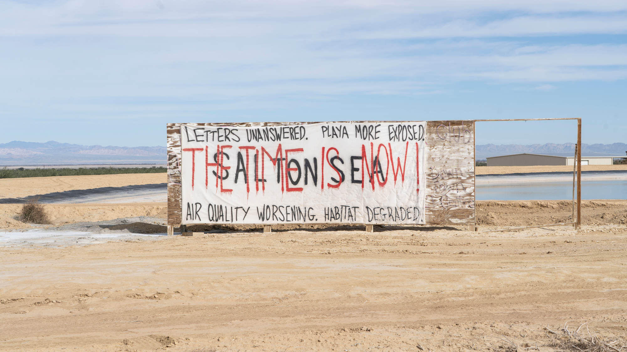
In January 2023, a banner visible from the highway reads “SALTON SEA” and “THE TIME IS NOW!” near the southern shore of the Salton Sea. For nearly a quarter of a century, scientists have warned the state of California that an ecological and public health catastrophe was imminent.
While the IID petition churned through the bureaucracy of the water board, which would not ultimately act on it for three years, the scientific community continued to advocate for a comprehensive science program at the lake. Barnum and others had spent seven years after the demise of the preferred alternative developing the Salton Sea Ecosystem Monitoring and Assessment Plan, a framework for how to integrate scientific inquiry into future management (the plan had no funding, and waited, as it said in its executive summary, “in anticipation of direction from the legislature”). In 2014, following the MAPS completion the previous year, Barnum, along with Cohen, the Pacific Institute researcher, and a biologist from the University of California Irvine named Tim Bradley, organized a meeting of some 50 scientists to assess the current state of Salton Sea science. The meeting yielded a package of research proposals, amounting to roughly $47 million, that would plug the perceived knowledge gaps at the lake and help guide state officials toward meaningful solutions. A summary report concluded: “The focus of immediate, urgent priority is related to air quality, fugitive dust, and related human-health issues.”
Still, the state failed to act. Cohen, hoping to capture the attention of policymakers by putting the problem in monetary terms, authored a sequel to his earlier report in which he argued that inaction also generated costs — but those costs would ultimately be borne by those least able to afford them: the residents of the area. He estimated that without state intervention, health care costs directly related to the dust could soar to $37 billion through 2047. Additional costs from decreased property values, potential loss of agriculture, diminished recreational revenue, and up to $26 billion in lost ecological value would combine to make restoration plans — even the $8.9 billion preferred alternative — seem frugal in comparison.
Cohen told Undark that he believes the report moved the needle somewhat. Still, he said, policymakers tend to incorporate science selectively, using “science if it supports their policy objectives. But if it doesn’t, then they ignore it.” He later added, “I’m used to being ignored.”
As the 15-year clock was running out on the mitigation water, scientists, once again, tried to sound the alarm. They attended meetings with agency managers, wrote op-eds, organized public speaking events. Tim Bradley, who headed a research effort at UC Irvine, helped launch a petition calling for the water transfers to be regulated until the state could implement mitigation measures. Years passed with no concrete action. “We just kept saying, ‘Is anybody paying attention?’ It’s very clear what the science is here, is anybody paying attention?’” recalled Bradley. “We just kept trying and we just kept trying.”
Finally, in March of 2017, the state of California, which had reorganized its efforts into a new initiative called the Salton Sea Management Program, released a 10-year plan calling for roughly 30,000 acres of habitat and dust suppression projects, to be completed by 2028. The plan, which was estimated to cost $383 million (and had secured funding for less than a quarter of that amount), no longer discussed restoring the Salton Sea — instead, it laid out a partial mitigation and management strategy for a “smaller and sustainable sea.” The original 2003 legislation committing California to the restoration of the lake had set an objective to attain “historic levels and diversity of fish and wildlife.” The new plan ignored that goal, instead aiming for simple acreage milestones — which together accounted for less than half of the playa expected to be exposed by 2028. Still, after 14 years of stagnation, the state now appeared committed to a course of action.
A few months after the release of the 10-year plan, the water board finally convened to settle the matter of the 2014 Imperial Irrigation District petition. Cohen, Bradley, and others traveled to Sacramento to speak, as did several residents of Mecca, a town on the north side of the lake. Bradley attempted to persuade the board to slow the water transfers until the state could catch up with its mitigation strategy. “It’s unconscionable,” he told them, “to wait for illness and deaths to manifest themselves in the communities around the sea before acting.” Later in the meeting, a young man from Mecca named Christian Garza spoke. Garza had suffered from asthma his whole life, and two years prior had nearly died from a collapsed lung during an attack. “I love the valley. I love my community. But I’m also scared of it,” he told the board.
“I will die in the valley if I stay there for more than five years,” he added. “I’ve seen the dust.”
The water board opted to allow the transfers to continue unchanged. But in an effort to improve California’s accountability, it obliged the state to reach the annual acreage goals laid out in the 10-year plan, and required that officials deliver an annual report updating the board on its progress. The order, however, completely lacked an enforcement mechanism. “The only tooth in there is shame,” Cohen told Undark. “It’s not clear how responsive they are to shame.”
On Jan. 1, 2018, the mitigation water essentially stopped flowing to the Salton Sea. The lake’s surface elevation began to decrease at nearly twice its previous rate, losing roughly a foot annually. To date, nearly 30 square miles of playa have been exposed — the equivalent of roughly 13,000 football fields. Meanwhile, the state has missed every single one of its acreage milestones, and each year it falls further behind.
In Brawley, decades of living with asthma have made Trianna Morales and Cyrus Ramirez adept at reading wind patterns. Morales uses a nearby crop of hills, called Superstition Mountain, as a quick and simple gauge of air quality — if they can see the hills clearly, criss-crossed by off-road tracks and buzzing with dune buggies and dirt bikes, they know to relax. If the hills appear hazy, though, or shrouded by plumes of blowing dust, Morales knows to keep their inhalers close, and pay keen attention to the sound of their children’s breathing. And if the wind is blowing from the north, the direction of the Salton Sea, they remain especially vigilant.
These are the subtle adaptations that occur over a lifetime of coping with asthma. Less subtle are the constant doctor’s appointments, the trips to the emergency room. Although Morales and Ramirez both connect their family’s asthma to the Salton Sea, they can’t afford to leave, and have lost faith that the state will ever do anything to improve the situation. “The word that comes to mind,” said Morales, “is ‘hopeless.’”
In the absence of much government intervention, residents of the so-called fenceline communities of Brawley, Westmoreland, Calipatria, and Niland, have tried to design and implement their own programs to reduce harm from the Salton Sea. The Brawley-based nonprofit Comité Cívico del Valle has developed a flag-warning system with local schools: each morning a green, yellow, orange, or red flag is hoisted in accordance with the day’s air quality risk. CCV also runs an asthma-education outreach program that sends workers into the community to teach families how to best protect themselves — the box-fan air purifier in Morales’s living room was brought over by their asthma outreach worker, who suffers from respiratory issues herself.
But preventative measures can only do so much. When severe asthma attacks strike, the emergency room at Pioneer Memorial Hospital in Brawley serves as the first line of defense. Oscar Garcia, the emergency room director, said that roughly 20 percent of admissions are pediatric respiratory cases. “Winter time, every day we have one, two, three, four, or more patients that come in with an asthma attack,” said Garcia. “Our supply of asthma tools and equipment is always ready.” Usually, the children respond to increasingly aggressive treatments with albuterol and steroids. Sometimes, though, they must be intubated and flown to Rady Children’s Hospital in San Diego. Garcia knows how distressing these ER visits can be for families — he used to have to take his own asthmatic son to the hospital about once a year.
A memorial altar for 12-year-old Tashia Taylor of Bombay Beach, who died after a severe asthma attack, is displayed in her family’s home. Although such deaths are rare, they rattle the community and add an urgency to calls for a solution at the Salton Sea.
Some children, though, don’t make it to the emergency room in time. In April 2022, in Bombay Beach, on the eastern shore of the Salton Sea, a 12-year-old girl named Tashia Taylor suffered a severe asthma attack after riding her bicycle near the shoreline. After several days on her nebulizer, her condition failed to improve. While her mother, Tashi Bolden, was out getting gas for her vehicle in case she needed to bring her daughter to the hospital, Tashia collapsed. Bolden says it took the paramedics 45 minutes to reach Bombay Beach from Brawley, during which time she and a police officer performed CPR on her daughter. But neither they, nor the paramedics when they arrived, were able to revive Tashia.
Although such deaths are rare, they rattle the community, and add a desperate urgency to calls for a lasting solution at the Salton Sea. Bolden, now haunted by grief, has a simple request for policymakers: “Clean it up,” she said. “Clean up that beach, that water.”
But Morales believes such pleas fall on deaf ears. Imperial County is poor, mostly Latino, and geographically set apart from the southern Californian urban centers of San Diego and Los Angeles. It’s not that policymakers are unaware of what’s happening there, said Morales, it’s that they simply don’t care. “We won’t probably get help until everybody else gets help,” said Morales. “We’re the bottom of the dogpile.”
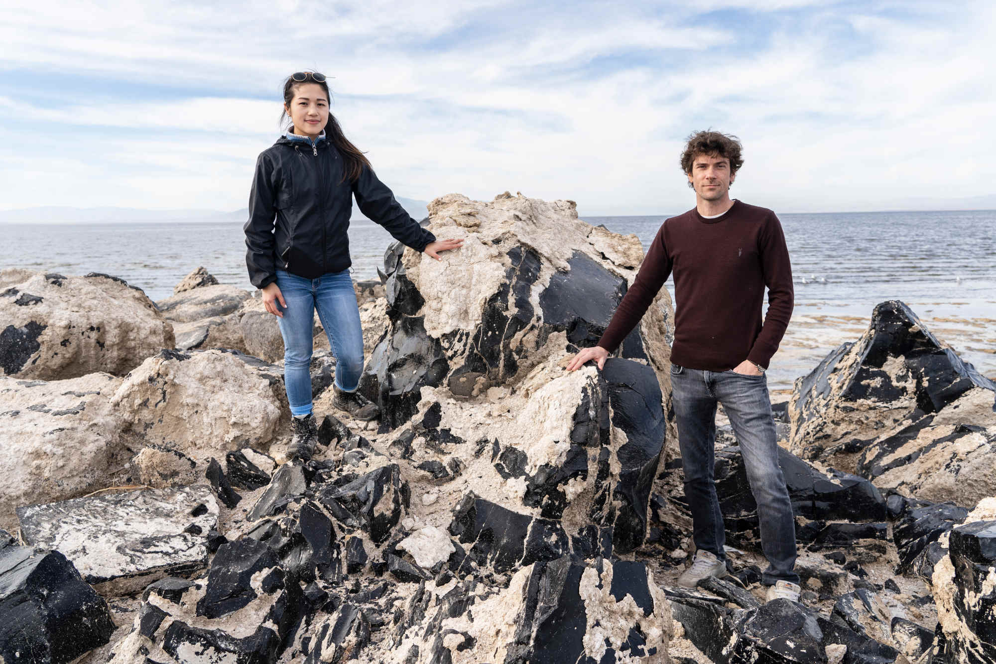
On an overcast morning in early January 2023, Charlie Diamond and Caroline Hung, geochemists from UC Riverside, pulled their car onto a dirt road leading to Obsidian Butte, a slight promontory of volcanic rock overlooking the Salton Sea. They parked on the far edge of the outcrop, then continued on foot through a sloping scree field of glassy black stone until they reached a view of the mud flats to the east. There, a wide sweep of barren earth stretched from the water’s edge to a pale band of vegetation some 200 yards away. “This is just a nice visual representation of the rapidly receding shoreline,” said Diamond.
“This is all recently exposed,” he added.
Diamond and Hung are members of the UC Riverside Salton Sea Task Force, an interdisciplinary research group that comprises the latest effort by scientists to mount an organized response to the unfolding regional catastrophe. As one of only two teams that studies the lake by boat, Diamond and Hung say that the dropping water level has begun to pose serious logistical challenges to their research. There are no longer any functioning docks at the Salton Sea, and to launch their 300-pound, fiberglass-hulled Zodiac, they must now drag it through mud that can feel like quicksand. “Every little foot the water has receded is going to pose like 30 more minutes of effort,” Hung said.
Of their ability to launch the boat on the lake, she added, “there’s going to be a limit.”
UC Riverside geochemists Caroline Hung (left) and Charles Diamond (right) at Obsidian Butte, a volcanic rock formation overlooking the Salton Sea. Diamond and Hung are one of two teams of researchers who study the lake by boat, which has become increasingly difficult as the shoreline from which they launch recedes.
In 2021, the task force published a report, in which the team noted “the absence of an adaptive, science-based approach to addressing the environmental and human health challenges at the Salton Sea.” By then, the state had finally broken ground on the Species Conservation Habitat, the 4,100 acre wetland complex that had originally been proposed as a smaller, 2,400-acre project 13 years prior. It had also begun implementing several hundred acres of temporary dust suppression projects on the newly exposed playa (mostly surface-roughening), although these were within the boundaries of the SCH and would be flooded upon its completion. But the task force argued that “although state agencies are making efforts to mitigate the problems, the scientific assumptions informing current management practices are outdated or lacking entirely, making outcomes unpredictable at best.”
In the report, as well as in subsequent interviews with Undark, the UC Riverside group flagged several worrisome oversights. The group’s hydrologist argued that the state’s hydrology model was incomplete, overlooking the potential for lake water to discharge into underground aquifers, as well as failing to explicitly represent how shifting human activities in the region could affect inflow. Additionally, the task force noted that the exposed playa will likely not be uniformly hazardous, and that, as the lake recedes, the exposed dust could become increasingly toxic. Mice exposed to that dust, the team found, displayed dramatic pulmonary inflammation, while mice exposed to control dust collected 50 miles away from the lake did not. That type of inflammation, the researchers noted, could present as asthma-like symptoms in humans.
For Timothy Lyons, a UC Riverside geochemist, the dust is especially worrisome given the changing demographics of the region. Spurred in part by a potential lithium bonanza (geothermal brine underground near the Salton Sea could contain enough lithium to meet one-third of the global demand), the population of the Salton Sea airshed is predicted to double in the coming years. “They’re talking about bringing thousands of people down there on the south shore of the Salton Sea,” said Lyons. “An area that by some measures should be evacuated.”
UC Riverside geochemist Timothy Lyons is concerned about shifting demographics around the Salton Sea. Due to a store of lithium far beneath the lake, the population of the region’s airshed is predicted to double in coming years.
Yet despite the increasingly well-understood dangers posed by the shrinking lake, the state’s response has stopped short of addressing the community’s health concerns. Tonya Marshall, a senior official with the state’s Salton Sea Management Program, said that the community’s health problems are beyond the scope of the current mitigation efforts. “That’s not where the goal of the SSMP was or is,” she said. “If somebody had stated ‘well, the SSMP’s goal is to make it better for all of humans there,’ then there would be that aspect of that. But our goal right now is 30,000 [acres] of the habitat and dust suppression projects with the 10-year plan.”
For many scientists, however, it is precisely that kind of rigid, compartmentalized thinking that lies at the core of the problem at the Salton Sea. “We can’t just put blinders on,” said Cohen. “We need to know what’s going on with the Salton Sea, not just how many acres we’re building.”
Diamond and Hung agree. “There’s a lot of disconnect,” said Hung. “Everybody’s just trying to do their job.”
On Dec. 3, 2022, a community advocacy group called the Salton Sea Coalition held a public forum at an auditorium in Palm Desert, about 30 miles northwest of the lake. Many of the members of the UC Riverside task force appeared as expert panelists, and the crowd (who appeared to largely support a hypothetical plan to import water from the Sea of Cortez, which many scientists view as unrealistic) listened attentively as they described the scientific nuances and lingering uncertainties at the lake. But at one point, frustration boiled over. During a Q&A with the scientists, a community member named Art Gertz took the microphone. “We’re being told we need more studies!” he quipped. “We should study why we need more studies!” For Gertz, a longtime advocate of importing water, the solution to the lake’s woes was blindingly clear: “Just. Add. Water!” he proclaimed. The crowd erupted in applause.
Sitting a few rows back, Diamond and Hung listened patiently. Gertz’s was an attitude they had encountered frequently in their outreach work, and although they disagreed with his viewpoint, they sympathized with the man’s frustration. Years of neglect, false starts, broken promises, blown deadlines, poor communication, and bureaucratic torpor had made locals weary of anything that smelled of can-kicking — they were desperate for action that would yield results. “That is a very real sentiment: ‘Enough studies, we need action,’” said Diamond. “I completely understand that sentiment.”
In December 2022, the Salton Sea Coalition held a public forum in Palm Desert, where experts described the scientific nuances and lingering uncertainties at the lake. But after years of false starts, broken promises, and blown deadlines, members of the community are desperate for action that will yield results. “Just. Add. Water!” community member Art Gertz proclaimed during the forum.
But in December 2022, after contemplating a range of potential restoration strategies beyond the lagging 10-year plan, California decided to punt to the Army Corps of Engineers, which, in partnership with the state and local stakeholders, recently initiated a study aimed at determining the best long-range course of action. It is anticipated to be done by 2025. Once completed, the agreed-upon plan must be delivered to Congress, which would only then decide whether to furnish federal funding to enact it. For a community whose children are sick and getting sicker, and whose exasperation is already white hot, the Army Corps study will likely only inflame the opinion that the lake is, as Gertz claims, being studied to death.
Researchers like Cohen, meanwhile, are left feeling ambivalent about the best path forward. Historically a staunch advocate for a rigorous, science-based approach, Cohen said that lately he’s been identifying increasingly with the position that the state should just do something — anything — and hope that it works. “On one hand, I think ‘Screw it, just build some projects.’ You get some water on the ground, birds are going to show up and vertebrates are going to populate those ponds. And then you’re going to minimize dust. So let’s just do that,” he said. “On the other hand, it’s kind of irresponsible to spend a billion dollars and not really know what’s going to happen.” Either way, as the ecosystem approaches critical thresholds and more playa is exposed each year, one fact has become vividly clear to Cohen: “We’ve run out of time.”
The problems at the Salton Sea have now persisted for so long that multiple generations of scientists have come and gone. Krantz, Barnum, and Bradley have now all retired, making way for a new generation — Diamond and Hung among them — to continue advocating for the role of science at the lake. Among the older generation, a certain jaded pessimism has settled in; Cohen said that the past two decades didn’t even feel Sisyphean, because “that suggests we actually got the rock to the top.” Particularly troubling to many scientists who spoke to Undark is the sense that local residents have been deemed acceptable collateral in the west’s great water wars. The Salton Sea, Krantz said, “boils down to one of the most serious, exigent environmental justice issues globally.” For younger scientists like Diamond and Hung, the inequities of the region have exerted a moral pull, shifting the priorities of their lives. Diamond, who has become besotted by the lake’s oblique, alien beauty, said that working on a problem with real-world implications has changed him. Now, he said, “I want to do things that have an impact.” Hung has been galvanized by her experiences at the Salton Sea into considering law school, so that she can study how to better incorporate science into policy. “I think it takes expertise in both to really think of a solution,” she said.
The Army Corps of Engineers recently initiated a study aimed at determining the best long-term course of action at the lake. The study is expected to be done by 2025. But as the ecosystem approaches critical thresholds and more playa is exposed each year, one fact has become vividly clear to researcher Michael Cohen: “We’ve run out of time.”
Yet just as the lake, and the region surrounding it, have drawn researchers in, others are desperate to get out. Morales and Ramirez believe their asthma, and Luna and Frederick’s, is getting worse. They say they are exhausted, and have lost all faith in anyone helping them or their community. “If we had money, obviously we would be gone,” Morales said. “But we just don’t.”
Still, they like to picture it: a farmhouse near Flagstaff, Arizona, with a wraparound porch and clean, mild wind. Or maybe somewhere near San Diego — they aren’t too picky. Morales has just one strict criterion: “I want it to be fresh,” they said. “I want to be able to breathe.”
Fletcher Reveley is a freelance writer based in Tucson, Arizona.
Kitra Cahana is a Peabody Award-winning documentary filmmaker and photographer.
This article was supported in part by The Water Desk, an independent journalism initiative based at the University of Colorado Boulder’s Center for Environmental Journalism.The Water Desk’s mission is to increase the volume, depth and power of journalism connected to Western water issues.
Farming in a 20-year drought is “hard for us,” says John Mestas, at his cattle ranch in Colorado’s San Luis Valley. Rising levels of arsenic in the water supply are linked to the drought. Melissa Bailey/KFF Health News
Now decades of climate change-driven drought, combined with the overpumping of aquifers, is making the valley desperately dry — and appears to be intensifying the levels of heavy metals in drinking water.
Like a third of people who live in this high alpine desert, Mestas relies on a private well that draws from an aquifer for drinking water. And, like many farmers there, he taps an aquifer to water the alfalfa that feeds his 550 cows.
“Water is everything here,” he says.
Mestas, 71, is now one of the hundreds of well owners participating in a study that tackles the question: How does drought affect not just the quantity, but the quality, of water?
The study, led by Kathy James, an associate professor at the Colorado School of Public Health, focuses on arsenic in private drinking wells. Arsenic, a carcinogen that occurs naturally in soil, has been appearing in rising levels in drinking water in the valley, she says. In California, Mexico, and Vietnam, research has linked rising arsenic levels in groundwater to drought and the overpumping of aquifers.
As the West grapples with a megadrought that has lasted more than two decades, and states risk cutbacks in water from the shrinking Colorado River, the San Luis Valley offers clues to what the future may hold.
Nationwide, about 40 million people rely on domestic wells, estimates Melissa Lombard, a research hydrologist for the U.S. Geological Survey. Nevada, Arizona, and Maine have the highest percentage of domestic well users — ranging from about a quarter to a fifth of well users — using water with elevated arsenic levels, she found in a separate study.
During drought, the number of people in the contiguous U.S. exposed to elevated arsenic from domestic wells may rise from about 2.7 million to 4.1 million, Lombard estimates, using statistical models.
Arsenic has been shown to affect health across the human life span, beginning with sperm and eggs, James says. Even a small exposure, added up over the course of a person’s life, is enough to cause health problems, she says.
In a previous study in the valley, James found that lifetime exposure to low levels of arsenic in drinking water, between 10 and 100 micrograms per liter, or µg/L, was linked to a higher risk of coronary heart disease. Other research has tied chronic exposure to low-level arsenic to hypertension, diabetes, and cancer. Pregnant women and children are at greater risk for harm.
The World Health Organization sets the recommended limit on arsenic in drinking water at 10 µg/L, which is also the U.S. standard for public water supplies. But research has shown that, even at 5 µg/L, arsenic is linked to higher rates of skin lesions.
“I think it’s a problem that a lot of people are not aware of,” Lombard says. “Climate change is probably going to impact water quality,” she said, but more research is needed to understand how and why.
A hotbed of hope
The San Luis Valley in southern Colorado, which has hosted a wealth of research and innovation, is the ideal place to explore those questions — and potential solutions.
A rainstorm hits the Sangre de Cristo mountains. The range’s snowmelt and rainfall replenish aquifers in Colorado’s San Luis Valley. But the area gets just 7 inches of rain in an average year. Melissa Bailey/KFF Health News
Known for its stunning mountain views and the nearby Great Sand Dunes National Park and Preserve, the valley spans a region roughly the size of Massachusetts, making it North America’s largest alpine valley. Rich in Indigenous, Mexican, and Spanish heritage, the valley contains 500,000 acres of irrigated land, producing potatoes, alfalfa for hay, and beer barley for Coors. It’s home to nearly 50,000 people, many of them farmworkers and about half of them Hispanic. It’s also a challenging place to live: Counties here rank among the poorest in the state, and rates of diabetes, kidney disease, and depression run high.
Since it rains very little, about 7 inches a year on average, farmers rely on two large aquifers and the headwaters of the Rio Grande River, which continues on to Mexico. Snowmelt from the looming Sangre de Cristo and San Juan mountain ranges recharges the supply each spring. But as the climate warms, there’s less snow, and water evaporates more quickly from the ground and crops.
“This entire community, this culture, was built around irrigated agriculture,” says state Sen. Cleave Simpson of Alamosa, a Republican and a fourth-generation farmer. But since 2002, the valley’s unconfined aquifer has lost 1 million acre-feet of water — or enough to cover 1 million acres of land in water 1 foot deep — due to persistent drought and overuse. Now the communities in the valley face a deadline to replenish the aquifer, or face a state shutdown of hundreds of irrigation wells.
“We’re a decade ahead of what’s happening in the rest of Colorado” because of the intensity of water scarcity, says Simpson, who manages the Rio Grande Water Conservation District.
“This is not drought anymore — this is truly the aridification of the West,” Simpson says. That’s how scientists are describing a long-term trend toward persistent dryness that can be stopped only by addressing human-caused climate change.
James, who is an epidemiologist and engineer, has been studying links between climate and health in the valley for the past 15 years. She found that during dust storms in the San Luis Valley, which have been growing more frequent, more people visit the hospital for asthma attacks. And she has surveyed farmworkers on how drought is affecting their mental health.
In the domestic well study, James is focusing on arsenic, which she says has been gradually increasing in valley drinking wells over the past 50 years. Arsenic levels in San Luis Valley groundwater are “markedly higher than [in] many other areas of the U.S.,” according to James. Arsenic concentrations have ranged from less than 2 to 150 µg/L between 1986 and 2014, James found in an earlier study. She is working on updating the data and also investigating ethnic disparities. One study there showed Hispanic adults had higher levels of arsenic in their urine than non-Hispanic white adults did. (Hispanic people can be of any race or combination of races.)
James now aims to test 1,000 private wells in the valley to explore the connections between drought, water quality, and health. So far, she said, a small proportion of wells show elevated levels of heavy metals, including arsenic, uranium, tungsten, and manganese, which occur naturally in the soil. Unlike public water supplies, private domestic wells are not regulated, and they may go untested for years. James is offering participants free water testing and consultation on the results.
Angie Mestas, a schoolteacher and John’s daughter, used her savings to drill a drinking well on her land. But she won’t drink from it until she tests it. Melissa Bailey/KFF Health News
In Conejos County, John Mestas’ daughter, Angie Mestas, jumped at the chance for a free test, which would cost $195 at a local lab. Angie, a 35-year-old schoolteacher, said she used a lifetime of savings to drill a drinking well on her plot of land, a wide-open field of chamisa with sweeping views of the San Luis Hills. But she won’t drink from it until she tests for arsenic and E. coli, which are common in the area. As she awaits test results, she has been hauling 5-gallon jugs of water from her father’s house each time she spends the weekend at her newly constructed yurt.
A colorless, odorless threat
Meanwhile, Julie Zahringer, whose family settled in the valley from Spain nearly 400 years ago, has been watching water-quality trends firsthand. Zahringer, 47, grew up driving a tractor on her grandfather’s ranch near San Luis, Colorado’s oldest town — and hanging out in the lab with her mother, a scientist.
As a chemist and laboratory director of SDC Laboratory in Alamosa, Zahringer tests private and public drinking water in the valley. She estimates that 25% of the private wells tested by her lab show elevated arsenic.
To Zahringer, the link to climate seems clear: During dry periods, a well that usually hovers around 10 µg/L of arsenic may easily double or triple in concentration, she says. One reason is that there’s less water to dilute the natural contaminants in the soil, though other factors are at play. The arsenic levels used to be fairly stable, she says, but after 20 years of drought, they’re fluctuating wildly.
“Now, more and more rapidly, I’m seeing the same well that I just tested three years ago — it doesn’t even look like the same well” because levels of contaminants have risen so much, says Zahringer, who also serves as a member of the Colorado Water Quality Control Commission. At her own drinking well, the arsenic level jumped from 13 to 20 µg/L this year, she says.
Zahringer’s observations are important firsthand anecdotes. James aims to explore, in a rigorous scientific study with a representative sample of wells and extensive geochemical data, the prevalence of arsenic and its connection to drought.
In California and Vietnam, research has linked rising arsenic levels in drinking water to land subsidence — when the ground sinks due to aquifer overpumping, which happens more during drought.
Meanwhile, community leaders in the valley are adapting in impressive and innovative ways, James says.
Zahringer said if arsenic shows up in a private well, she encourages clients to install reverse osmosis water filtration at the kitchen sink. The equipment costs about $300 from an outside supplier, though filters costing less than $50 may need to be changed every six to 18 months, she says. People who treat their water for arsenic should continue to test every six months to make sure the filters are effective, says Zahringer. SDC Laboratory offers an arsenic test for $25.
“People don’t want to test their water because it tastes good and their grandpa drank it,” she said. But “the cure for it is so easy.”
A water-quality campaign in 2009, led by the San Luis Valley Ecosystem Council, also found elevated arsenic in wells across the valley. As part of its outreach, the nonprofit worked with real estate agents to make sure that domestic wells are tested before someone buys a home.
That’s what Sally Wier did when she bought a house five years ago on an 8-acre plot in Rio Grande County surrounded by fields of barley and alfalfa. The first time she tested her well, the arsenic level was 47 µg/L, nearly five times the EPA’s limit. Wier installed a reverse osmosis water filtration system, but she said the arsenic level rises before she changes the filters every few months.
“It makes me really anxious,” said Wier, 38. “I’m probably ingesting arsenic. That is not good for long-term health.”
Wier is one of many people working on innovative solutions to the water shortage. As a conservation project manager for Colorado Open Lands, she worked on a deal by which a local farmer, Ron Bowman, was paid to stop irrigating his 1,800-acre farm. The deal marks the first time in the country that a conservation easement has been used to save groundwater for aquifer replenishment, Wier says.
Funneling money toward a solution
In Costilla County, the Move Mountains Youth Project has been paying local farmers, through a government grant, to convert a portion of their land to grow vegetables instead of water-intensive alfalfa. Farmers then train youth to grow crops like broccoli, spinach, and bolita beans, which are sold at a local grocery store. The project aims to nurture the next generation of farmers, and “beat diabetes” by providing locally grown food, says executive director Shirley Romero Otero. Her group worked with three farmers last summer and plans to work with seven this season, if enough water is available, she said.
In another effort, farmers like the Mestas are taxing themselves to draw water from their own irrigation wells. And Simpson, of the Rio Grande Water Conservation District, recently secured $30 million in federal money to support water conservation. The plan includes paying farmers $3,000 per acre-foot of water to permanently retire their irrigation wells.
Since arsenic is not limited to private wells, public agencies have responded, too: The city of Alamosa built a new water treatment plant in 2008 to bring its arsenic levels into compliance with federal standards. In 2020, the state of Colorado sued an Alamosa mushroom farm for exposing its workers to arsenic in tap water.
At the High Valley Park mobile home park in Alamosa County, Colorado, tenants have been drinking bottled water for years due to concerns about their well water. Sometimes it comes from the tap brown. Melissa Bailey/KFF Health News
At the High Valley Park mobile home community in Alamosa County, a well serving 85 people has exceeded legal arsenic levels since 2006, when the Environmental Protection Agency tightened its standard from 50 to 10 µg/L. At the most recent test in February, the concentration was 19 µg/L.
On an April afternoon, four children bounce on a trampoline and chased one another up a tree.
“Uncle, I’m thirsty and there’s no bottled water left,” said one child, catching her breath.
The well serves 28 households. But tenants from five homes say they haven’t been drinking the water for years, not because of arsenic — which some said they were not aware of — but because the water often comes out brown.
Eduardo Rodriguez, 29, who works in excavation, says he buys two cases of bottled water every week for his wife and five children.
“It needs to be fixed,” he says.
“The water sucks,” agrees Craig Nelson, 51, who has lived in the mobile home park for two years. “You don’t drink it.” Because the well serves at least 25 people, it is regulated by the state.
Landlord Rob Treat, of Salida, bought the property in February 2022 for nearly half a million dollars. Getting arsenic within federal standards has been difficult, he says, because arsenic levels fluctuate when nearby farmers tap the aquifer to irrigate their crops. Treat was using chlorine to convert one kind of arsenic into a more treatable form. But if he added too much chlorine, he says, that created its own toxic byproducts, which have also flagged regulators’ attention.
Under pressure from the state, Treat began upgrading the water treatment system in May, at a cost of $150,000. To cover the cost, he said, he aims to raise the monthly rent from $250 to $300 per lot.
“If the state would stay out of it,” he grumbled, “we could supply affordable housing.”
Meanwhile, John Mestas is still awaiting results on his drinking well.
When he returns from traveling out-of-state to move his cattle herd, “the first thing I do whenever I walk in the house is drink me two glasses of this water,” Mestas says. “That’s the one thing I miss, is my water and my dogs. They’re jumping all over me while I’m drinking my water. I don’t know who’s happier, me drinking the water or them jumping on me.”
This article was supported by The Water Desk, an independent journalism initiative based at the University of Colorado-Boulder’s Center for Environmental Journalism.
KFF Health News, formerly known as Kaiser Health News (KHN), is a national newsroom that produces in-depth journalism about health issues and is one of the core operating programs at KFF — the independent source for health policy research, polling, and journalism.
The Water Desk’s mission is to increase the volume, depth and power of journalism connected to Western water issues. We’re an initiative of the Center for Environmental Journalism at the University of Colorado Boulder. The Water Desk launched in April 2019 with support from the Walton Family Foundation. We maintain a strict editorial firewall between our funders and our journalism.
Tohono O’odham Nation’s San Xavier District Chairman Austin Nunez hikes through BLM land after surveying Hudbay’s mining operation in the foothills of the Santa Rita mountains south of Tucson, Ariz. on Friday, March 11, 2023 Credit: Michael McKisson
Austin Nunez, Chairman of the San Xavier district of the Tohono O’odham Nation, walks through the desert grass, nimbly weaving between ocotillo and barrel cactus, climbing up a pathless foothill of the Santa Rita Mountains just south of Tucson.
Water Desk Grantee Publication
This story was supported by the Water Desk’s grants program.
Wearing black Lowa hiking shoes, blue jeans, a light long-sleeve button down shirt, with a black bag over one shoulder and a Tohono O’odham baseball hat on his head, he takes a moment, leans down, and admires a rainbow hedgehog cactus.
Continuing to climb, after gaining enough elevation to gather in the full view, he turns around to look at the site of the proposed Copper World Complex mine, a vast area of once-pristine desert grassland rising into an imposing mountain range. Though actual digging for copper and other minerals may still be years or decades away — if it happens at all — the Canadian mining company Hudbay, has, over the past year, already clearcut huge tracts of scrub and cactus and carved a network of roads and berms out of this patch of desert.
Nunez takes in the scene before him, sighs heavily, and, then, under his breath, says “Whoa.”
He takes another deep breath: “I’ll be nice about it. They’re raping mother earth.”
The Santa Rita mountains, or Ce:wi duag in the Tohono O’odham language, are a favorite spot for Southern Arizonans to go hiking, camping, or birding. The Ciénega Creek, one of Arizona’s most intact riparian areas, and from which Tucson takes a significant amount of its annual water, flows between the Santa Ritas and Whetstone Mountains.
Nunez says of the proposed mine, “It’s very short-sighted. They’re going for temporary economic gain and aren’t concerned about the future, how the mine will affect the wildlife and the waterflow.”
In a June 5 emailed comment from Hudbay, a spokesperson wrote to Arizona Luminaria that the company’s plan is to “not only responsibly extract minerals, but also produce finished copper on-site.”
Addressing concerns about wildlife and water contamination, Hudbay noted that the Army Corps of Engineers, in March 2021, concluded “that there are no jurisdictional waters in the area,” meaning that the washes do not meet the threshold of prompting federal protection.
An aerial image of the work being done by Hudbay in the Santa Rita mountains south of Tucson on March 10, 2023. Credit: Michael McKisson
A new hydrology report published last November, commissioned by EarthJustice, the nonprofit law firm that represents the Tohono O’odham, Pascua Yaqui and Hopi tribes that are challenging Hudbay in court, shows how the giant mining operation would have enormous detrimental impact on local waterways, including the Santa Cruz River which flows north through the heart of Tucson.
The land these rivers and washes flow through shows signs of having been inhabited for as long as 10,000 years, and has long been a dwelling and gathering place, as well as a sacred site, for the Hohokam and Tohono O’odham people. Today, it is one of the last remaining habitats in the country for the jaguar, as well as multiple other endangered species. The famous Arizona Trail, on which hikers can walk from Mexico to Utah, passes directly through land that would become a half-mile deep scar into the earth.
“‘Ridgeline modification,’ they call it,” says Russ McSpadden, southwest conservation advocate for the Center for Biological Diversity, who is hiking with Nunez. “But it’s mountaintop removal. They’re completely changing the view.”
Even as the legal saga over whether or not Hudbay can start digging plays out in courts and among government regulators, Hudbay has been able to push forward on preliminary work. Though what they’ve done so far is only a negligible fraction of what multiple open pit mines will do to the landscape, critics note that the company has already affected the local waterways and scarred land that is both beloved and sacred.
Hudbay officials know they have a long path ahead of them before they may be able to actually extract copper. Their current goals, according to a 2023 management discussion posted on their website, include “the completion of pre-feasibility studies, state permitting activities, evaluating a bulk sampling program and a potential joint venture partnership.”
A handwritten sign warns drivers of road work by Hudbay in the foothills of the Santa Rita mountains south of Tucson on Friday, March 10, 2023. Credit: Michael McKisson
Mark Murphy, the geologist who wrote the hydrology report, is one of the leading experts in the Clean Water Act, which regulates how mining and other projects must address local impact on hydrology systems. Murphy estimated that the Santa Cruz River supports eighty-four species of mammals, fourteen fish species, and forty-one species of reptiles and amphibians, and provides habitat for millions of migrating and resident birds and waterfowl each year. In other words, blocking, draining, or polluting the tributaries that feed the Santa Cruz would affect an entire ecosystem.
In the report, Murphy concludes that “the physical, chemical, and biological integrity” of the Santa Cruz River depends on the upstream “ephemeral tributaries.” The very streams the digging of the mine would irrecoverably threaten.
McSpadden has seen first hand what Murphy has concluded in his report. “The whole thing drains right into the Santa Cruz,” McSpadden says. “I’ve come out here during the monsoons and you can see the flow. They’re already blocking these streams and they don’t have the permits to do that.”
Nunez and McSpadden pass binoculars back and forth as they survey the extent of the damage.
“I pray every day that it will be stopped in some way or another,” Nunez says.
A winding timeline
It’s not easy to track all the flip flops in the Copper World Complex mining saga. Even keeping track of what the project is called — for years it was known as the Rosemont Mine — and where exactly Hudbay is proposing to dig can be hard to follow. Some background helps put into perspective the whiplashing ping-pong of permits granted, permits denied, and permits revoked, and how Hudbay has still managed to conduct significant preliminary work despite the ongoing legal tug-of-war.
Though the northern reaches of the Santa Ritas have been mined at small scale — think pick and shovel, maybe a team of donkeys — for over 100 years, hopes for massive, industrial-scale mining began in the 1970s when Anaconda Copper started seeking to buy up land in the area. The corporation then merged with another, changed its name to Asarco, and then another corporation swooped in, and finally Hudbay took over speculative permitting and exploratory drilling in 2014.
A Hudbay employee sits at the entrance to the mining operation in the Santa Rita mountains south of Tucson, Ariz. on Friday, March 11, 2023. Credit: Michael McKisson
Hudbay has been wrangling with Pima County, Tucson, Sahuarita, and a host of state and federal agencies to counter the concerns of environmentalists and obtain the stack of permits needed before it can start digging. But resistance to the large-scale mine has been fierce. While objections range widely, the most feared impact concerns how the proposed mine would pollute and disrupt local waterways.
Those concerns were fought over and litigated all the way up to the U.S. Supreme Court, as justices sought to tease out which bodies of water should be considered “waters of the United States,” thus putting them under the regulatory protection of the Environmental Protection Agency.
The Supreme Court heard arguments in a case last summer, and just issued a ruling on May 26 in a decision the White House said in a statement “will take our country backwards” in terms of protecting threatened waterways.
While the ruling narrows the definition of what is considered a waterway, and is a win for mining companies, not all the red tape is cleared for Hudbay. Federal bills on both sides of the issue are currently wending their way through the legislature.
Arizona Luminaria reached out to Sinema’s office on June 8 with a list of questions about her stance on the proposed mine in the Santa Ritas. As of June 26, her office has not responded.
In April, U.S. Sens. Catherine Cortez Masto (D-Nev.) and Jim Risch (R-Idaho) introduced the Mining Regulatory Clarity Act, co-sponsored by Sinema, which would allow mining companies to use federal land to dump their tailings. According to a Center for Biological Diversity press release, the move “could result in millions of acres of public lands becoming mining wastelands, putting that use above watershed protection, cultural resources and recreation.”
Rep. Raúl Grijalva (D-Ariz.), who opposes the Copper World Project, recently introduced the Clean Energy Minerals Reform Act, to protect the Santa Ritas, as well as other vulnerable sites, from mining.
“For more than a century and a half, the mining industry has operated under an outdated, free-for-all claims system that gives them carte blanche to pollute and destroy, while American taxpayers get stuck with the cleanup bill,” Grijalva wrote in a press release.
Hudbay work on the mining operation in the foothills of the Santa Rita mountains south of Tucson on Friday, March 11, 2023. Credit: Michael McKisson
It’s not only the federal agencies that need to approve. The Arizona Department of Environmental Quality has pulled rank on Pima County to be able to issue Copper World’s air quality permit, calling the county’s previous denial of a permit “arbitrary and capricious.”
The county has long been in opposition to the proposed mine. The city of Tucson, too, has long opposed any company digging in the Santa Ritas. The existing air quality permit for the Rosemont mine expires this April 23, so it will be up to the department of environmental quality to issue an extension — or not.
On March 10, when Chairman Nunez and McSpadden climbed hills in the area to survey the damage, dirt-hauling trucks were bumping along the roads, and a Hudbay sign read “Road Work. Proceed with Caution.”
Water and mining
In addition to building up infrastructure in preparation for digging, Hudbay’s current work includes preparation for a utility corridor to facilitate a water pipeline and high-voltage electric transmission lines along Santa Rita Road, on the east side of the range, north of the town of Sonoita.
That preparatory work highlights how deeply impacting the mine could be on the local environment: not only will it block and contaminate surrounding washes, critics say it will suck up huge amounts of water just to run the mine.
Hudbay documents show they will initially use up to 6,000 acre-feet of water per year from the local watershed. The company is authorized to pump 6,000 acre-feet per year at their Sahuarita wellfield for 20 years. Hudbay’s Preliminary Economic Assessment issued in June of 2022 indicates that the first phase of operations will require 9,400 acre-feet per year, rising to 14,000 acre-feet per year in Phase 2.
A single acre-foot of water is 325,851 gallons, or the amount of water needed to cover an acre of land a foot deep — a lot of water for the desert. The company also says that its total water usage is unclear, as it will be “determined by the size and technology of the final project as permitted,” and states that its goal is to become a “net neutral water user by recharging 100% of the water” used during production as a “voluntary measure.”
Recharging groundwater is pumping it back into the aquifer. According to the United States Geological Survey, that can be done by redirecting water via canals or “injection wells” which pump water into underground reservoirs.
Furthermore, Hudbay contends that whatever washes or arroyos it may alter are not proper waterways, which is one of the marquee fights over the proposed mine.
Mark Murphy, the writer of the hydrology report, spoke to Arizona Luminaria before the recent Supreme Court ruling about whether or not the washes were proper waterways. While he said that it depends on who you ask and under what administration you ask it, in the end, “there is a connection between ephemeral streams and downstream waters,” Murphy says.
“If water that supports ecological integrity is denied, or made less healthy, there will be an impact on downstream, and it won’t be good,” Murphy says.
HudBay has addressed some of these hydrological concerns on its website, explaining, “To be a good neighbor – and an innovative project – Rosemont has committed to replacing all of the water used in its operations.”
In a June 5 emailed comment from Hudbay, a spokesperson wrote to Arizona Luminaria that the company has “studied the ability of the dry washes on the west side to transport contaminants downstream by analyzing stormwater, sediment, and plant samples. The analysis is clear that contaminants from the historic mining activities in Helvetia do not reach the Santa Cruz River, and certainly do not reach the Colorado River, which is the nearest downstream water that is actually navigable.”
Russ McSpadden, left, the Southwest conservation advocate for the Center for Biological Diversity points out a feature of Hudbay’s mining operation to Tohono O’odham Nation’s San Xavier District Chairman Austin Nunez on Friday, March 11, 2023. Credit: Michael McKisson
“Inherently incredibly destructive”
Dr. Julia Neilson is the director of the University of Arizona’s Center for Environmentally Sustainable Mining. “Hardrock mining of copper is inherently incredibly destructive,” Neilson said.
“The fact is, unfortunately, copper doesn’t always exist in convenient places to mine it,” she says.
Nunez and others, meanwhile, suggest a lifestyle change may be necessary.
“It’s heartrending to see this land destroyed because of the need to have tools and devices that we didn’t need before,” Nunez said. “We need to think twice about taking care of mother earth, if we don’t take care of her, we don’t take care of ourselves.”
To make matters more complicated, Neilson added that in the desert it takes an especially long time for ecosystems to recover once giant holes are dug into them.
The pit Hudbay proposes to dig, Neilson said, will be “a permanent problem.”
In response, the Hudbay spokesperson said, “Before, during, and after mining is complete Hudbay is taking into consideration the best way to operate in a sustainable manner and that protects the environment.” They added, noting their reclamation efforts, “Modern mining begins with the end in mind.”
An aerial panorama of the Hudbay mining operation in the Santa Rita mountains south of Tucson on Friday, March 11, 2023. Credit: Michael McKisson
Local resistance
Steve Brown, in his mid-70s, grew up on Santa Rita ranch, in the northern foothills of the mountain range. Steve, as well as his grandfather and grandchildren, have all learned the ins and outs of the foothills and ranges: where to spot deer and coatamundi, where to find seeps and springs.
“How does it enhance the safety and public health to allow a foreign company to dump toxic waste into the environment?” Brown asks. Hudbay has been pushing the state land trust to sell them land to use to deposit mining waste on, according to memos on April 17 and June 6 to the Pima County Board of Supervisors.
The company is also buying and offering to buy residential property in a Vail neighborhood that butts up against that state land trust-owned property, according to documents submitted to the Pima County Board of Supervisors.
The spokesperson for Hudbay said that “Phase I of Copper World will require Hudbay to obtain state and local permits to begin operations. The state’s permitting process includes the opportunity for members of the public to review the data and information, ask questions, and provide comments to regulators prior to the issuance of the permits.” They added that there will be public hearings for people to air their concerns.
That promise doesn’t pacify Brown.
“We will fight this for as long as it takes,” Brown says. “It really upsets me when someone from Hudbay comes and says ‘There’s nothing here,’ which is basically what they’re saying. I was raised in those mountains. They have been considered sacred for thousands of years. They’re not called Santa Ritas by accident.”
Tohono O’odham Nation’s San Xavier District Chairman Austin Nunez surveys Hudbay’s mining operation in the foothills of the Santa Rita mountains south of Tucson on Friday, March 11, 2023 Credit: Michael McKisson
“Heartrending to see the demolition”
Nunez and McSpadden turn from the cut-up western foothills to admire Huerfano Butte, a lone peak, or inselberg, that is the site of pictographs and potsherds, long a sacred site for pilgrimage and ceremony for the Tohono O’odham. Nunez explains that O’odham people from the Tucson area would visit the site before they continued into the mountains to collect material for baskets, medicines, and acorns.
“This is where we come to pray and recreate,” he says, looking out again at the road-scarred foothills in front of him.
Nunez has been chairman of the San Xavier district for 36 years. “I never imagined I would be serving my community this long. I started because I wanted to help my children, so they could have the same or better than I had.”
His youngest grandchild, seven years old, is named Alaya. “I’m concerned about the availability of water for her, about the way the climate has changed. I’m concerned for her children and grandchildren.”
The Water Desk’s mission is to increase the volume, depth and power of journalism connected to Western water issues. We’re an initiative of the Center for Environmental Journalism at the University of Colorado Boulder.
Lake Nighthorse, near Durango, Colorado on May 26, 2023. Both of Colorado’s tribes, the Southern Ute Indian Tribe and the Ute Mountain Utes have water in Lake Nighthorse they haven’t been able to access. Credit: Mitch Tobin/The Water Desk, with aerial support by LightHawk.
Federal and state officials have promised more tribal inclusion on the next round of negotiating the operating guidelines for the Colorado River, but what exactly that will look like is still unclear.
On June 16, the Bureau of Reclamation released a notice of intent (NOI), which formally advanced the process for the development of new operating guidelines for the nation’s two largest reservoirs, Lake Powell and Lake Mead. In the document, Reclamation says that during the upcoming guidelines negotiations, it intends to develop an approach that facilitates and enhances tribal engagement and inclusivity. Officials say they will also prioritize regular, meaningful and robust consultation with tribal nations.
“Existing forums and groups will be continued and leveraged, such as the monthly Reclamation-hosted Tribal Information Exchanges,” the NOI reads. “Reclamation is also exploring options for increasing tribal involvement through the potential development of new groups and forums.”
Tribes have historically been largely excluded from policy talks and some have said they only learn about decisions made by the seven states and federal government after the fact.
U.S. Bureau of Reclamation Commissioner Camille Touton previewed the NOI the week before it was released, speaking at a law conference on natural resources at the University of Colorado Boulder.
“We are looking to stand up a forum in which we are engaging with tribal nations,” she said. “There will be a specific framework how we engage with the tribes.”
A Reclamation spokesperson said they don’t have any details to add at this time about what the framework will look like beyond Touton’s comments.
The Colorado River basin’s 30 tribes have rights to use about 25% of the water, a percentage that is slowly increasing as river flows decline overall due to drought and climate change. And most of their rights are senior to nearly all other water users in the basin.
Although they were not included in the Colorado River Compact that divided the river, giving half of the flows to the upper basin and half to the lower basin, the 1908 Winters Doctrine reserved water rights for tribes. The doctrine established tribes’ water rights on the same date the federal government established their reservation, but not the amount of water to which they were entitled.
Tribes have had to quantify and settle their water rights within their states and tribal water comes out of each state’s allocation from the Colorado River. Unlike other water users, tribes don’t have to put the water to beneficial use to hang onto the rights for future development. That means there are unquantified water rights out there on paper that have never been used, although some tribes say they still fully intend to develop their water.
But in an already over-allocated system, any new water project that takes more from the Colorado River could be problematic. Tribes’ unused water has been propping up the system for years, and when finally put to beneficial use, it could exacerbate shortages for other water users.
“Water that is undeveloped tribal water rights is sitting in Powell and being used in some way, shape or form at some point,” said Becky Mitchell, commissioner to the Upper Colorado River Commission. “Somebody else is benefiting from it. Who benefits from continuing the way that we have, that’s the question we need to ask ourselves.”
Lake Nighthorse, near Durango, Colorado on May 26, 2023. Bureau of Reclamation officials have promised more tribal inclusion in the negotiation of the post-2026 reservoir operating guidelines. Credit: Mitch Tobin/The Water Desk, with aerial support by LightHawk.
Structural inclusion
The seven basin states — Colorado, Wyoming, Utah, New Mexico, California, Arizona and Nevada — negotiated the current interim guidelines for reservoir operations in 2007, and the guidelines are set to expire at the end of 2026. Developed in response to drought conditions in the first years of the century, the 2007 guidelines set shortage tiers based on reservoir levels and spelled out which states in the lower basin would take shortages and by how much their water deliveries would be cut in dry years.
Every component of the 2007 guidelines — and then some — is up for renegotiation as water managers figure out river management post-2026, said Anne Castle, a federal appointee and chair of the Upper Colorado River Commission. Castle is also on the leadership team for the Colorado River Basin Water & Tribes Initiative.
“There’s also discussion about broadening the scope of what will be considered in this set of guidelines,” she said. “That could include environmental benefit for the river. It could include development of undeveloped tribal rights. It could include a number of things that have not been previously part of the river operations plumbing discussion.”
One thing on which many agree is the need for tribes’ structural inclusion, meaning their seat at the table will be formally guaranteed and won’t be dependent on the promises of individual state or federal officials who could be replaced at the whims of a new administration. Tribal inclusion was a focus of the CU conference and included a panel discussion with representatives of 14 of the 30 tribes from across the basin.
“We really want tribes to be part of the negotiations and the discussions and the development of the post-2026 operational guidelines and we want this to be institutionalized as well,” Lorelei Cloud, vice chair of the Southern Ute Indian Tribe in southwestern Colorado, said as a panelist at the CU conference.
“Having a formal process is what’s needed,” said Cloud, a director on the Colorado Water Conservation Board, representing the San Miguel/Dolores/Animas and San Juan river basins. “It didn’t happen in 1922 or before, so we know it really needs to be in writing as we go forward.”
A conference panel at the University of Colorado Boulder featured representatives from 14 tribes from across the Colorado River Basin. Tribes say their structural inclusion is key. Alex Hager/KUNC
How to do it
Each tribe is a sovereign government with their own unique water issues, which creates challenges when trying to include everyone.
“If you know one tribe, you know one tribe,” said Daryl Vigil, co-director of the Water & Tribes Initiative, water administrator for the Jicarilla Apache Nation and panel moderator at the CU conference. “To think there’s an Indian solution really dishonors that individuality and uniqueness of those tribes.”
In 2020, the Water & Tribes Initiative released a report called “Toward a Sense of the Basin: Designing a Collaborative Process to Develop the Next Set of Guidelines for the Colorado River System.” In it, the report’s writers set out potential options for tribal participation, including a Sovereign Review Team (SRT) and a Tribal Advisory Council (TAC). An SRT would consist of federal, state and tribal representatives; would treat tribes as equal players with the states and federal government; and would be an advisory group and the main forum to receive input from stakeholders and the public. A TAC would include representatives from each of the 30 tribes in the basin.
“One of the real issues is how do you choose tribal representatives that would represent more than their own tribe. That’s very problematic,” Castle said. “But at the same time, it’s recognized that having representatives of seven states and 30 tribes sitting in a room is a logistical problem and difficult to have meaningful discussions with that many people. There are logistical issues that need to be talked about further and worked out.”
Representatives from the upper basin states (Colorado, Wyoming, Utah and New Mexico) and upper basin tribes have been meeting over the past year, usually on tribal territory, partly in an effort to strengthen relationships between water managers. Vigil said that representatives from the group of 14 tribes, known as the basin tribal coalition, have also been meeting over the past year with the seven basin states to talk about collaboration. He said his hope is that tribes will also have to be signatories, along with the seven basin states and the federal government, on governing policy documents — such as the post-2026 guidelines — regarding river operations.
“Tribes understand that this is probably one of the most important components in terms of the forward movement of water policy in the basin: to have structural inclusion in the decision-making process,” he said.
Mitchell said tribal inclusion and engagement is a top priority for her going into the negotiations. Her commitment to the tribes includes communication, consultation and coordination on decision-making, she said.
“I view their involvement as critical and imperative to the success of the post-2026 reservoir operations negotiations,” Mitchell said. “It’s no secret when the compact was signed in 1922, no tribes were involved, consulted or even informed. I cannot alone correct that, but we can do better and we should do better, and we have a responsibility to do better.”
Colorado has two tribal nations, the Southern Ute Indian Tribe and the Ute Mountain Utes. They both settled their water rights with the state in 1986. But that doesn’t mean they can put their water to beneficial use. The Southern Ute Indian Tribe has about 38,000 acre-feet of stored water for municipal and industrial use in Lake Nighthorse, part of the Bureau of Reclamation’s Animas-La Plata project. But because of a lack of infrastructure and high operation and maintenance costs, they haven’t been able to access it.
“In a perfect world, I want to see the federal government fulfill its obligations to the tribal nations,” Mitchell said. “That includes its responsibility to consult with the tribes on a sovereign to sovereign basis and to support the tribes in accessing and utilizing their water resources.”
The Water Desk’s mission is to increase the volume, depth and power of journalism connected to Western water issues. We’re an initiative of the Center for Environmental Journalism at the University of Colorado Boulder.
Climate change has come home to Durango, with a new study indicating that the once water-rich mining and railroad mecca is much drier than it once was, so dry in fact that the city can no longer depend solely on direct flow from the Florida and Animas rivers for a reliable supply of water.
Like other small towns in Colorado, Durango has very little water storage, enough to last for less than 10 days. It has always relied on its ability to pull water directly from the Florida River, using the Animas River as backup. But that is no longer possible, prompting the city to fast-track a major regional pipeline project to tap storage in Lake Nighthorse and to double down on conservation.
Larger cities often have water storage reservoirs that can carry them for months if not years during dry periods. But that’s not necessarily the case in smaller rural and mountain towns.
A new study of stream gage data conducted for Durango by the Silverton-based Mountain Studies Institute (MSI) shows that average annual precipitation in one of the town’s major watersheds has declined as much as 19.7% annually since the late 1980s and runoff, the water that eventually makes it to the stream, has dropped even more, as much as 35.7% in the Florida (pronounced Floreeeda) River watershed. The same trend, though to a much lesser extent, is also showing up in the Animas River watershed.
“It’s eye opening,” said Jarrod Biggs, Durango’s assistant finance director who has overseen much of the city’s recent water planning efforts. “It’s confirmation of what our anecdotal evidence has told us. It doesn’t go down to nothing, but it is a significant difference from where we were a decade or two ago.”
Jake Kurzweil, a hydrologist and associate director of water programs at MSI who conducted the study, said the declines help illustrate on a local level how watersheds have begun to dry out as the climate warms. The data also measures how much water the natural environment uses, essentially intercepting runoff before it can reach streams, which cities, farmers and industry tap for their water supply needs.
In the Florida River analysis, a measure known as the runoff ratio is markedly declining. The ratio is obtained by taking annual runoff and dividing it by precipitation.
“The runoff ratio is showing us how efficient the watershed is at generating water. Not only are we getting less precipitation, the efficiency of the watershed is also declining. My hypothesis is that we are well below the environmental demand for water,” Kurzweil said.
Similar trends are showing up in the Animas watershed, but right now they are not as alarming as those in the Florida. Kurzweil said because the Animas watershed is bigger and its terrain is more diverse, it is better protected from the harsh temperatures and strong sunlight that have driven the drying trends on the Florida River.
Peter Goble, a climatologist at the Colorado Climate Center housed at Colorado State University, cautioned that the region’s 1,200-plus-year megadrought likely exaggerates the level of declines seen in the MSI data. He also said that long-term climate warming forecasts don’t show dramatic drying trends in the next 30 to 40 years.
“[Kurzweil] is comparing a time when we scarcely had any droughts to a period that has been quite dry. Precipitation can vary widely and our climate models don’t show this clear drying signal…if anything climate models show that precipitation may increase just a little bit,” Goble said.
“Yes it’s getting warmer, yes we do need to be concerned about that, yes it does put pressure on our environmental systems. However I don’t like comparing [1985-1999 to 2010-2021] specifically because you are capturing the high side and the low side,” Goble said, referring to the time periods MSI used in its analysis.
Kurzweil acknowledges that the megadrought has exacerbated the drying seen in Durango’s river systems, but he said he thinks the trend will likely continue, in part because though Northern Colorado could see more precipitation as its climate warms, Southwestern Colorado could be drier because it is so much farther south.
The Florida and Animas rivers are part of the San Juan/Miguel/Dolores river basin. Regional officials are tracking the local trends closely.
Ken Curtis is general manager of the Dolores Water Conservancy District in Cortez, a 50-minute drive west of Durango. Curtis is working with a slate of forest, climate and water specialists to find ways to create healthier forests that are less prone to wildfires and better able to sustain water production as the climate continues to warm up.
“Clearly the southwest is a drier area than the northern parts of Colorado,” Curtis said. “Climatologically we’re closer to a desert and we are at lower latitudes.”
Durango’s Biggs said the city had been planning to build a pipeline from Lake Nighthorse, a federal reservoir built in the early 2000s, at some point in the future to provide access to more storage. But such a project, likely to cost tens of millions of dollars, had been seen as a long-term goal, not an immediate need.
The new analysis has prompted Durango to fast-track the project and to keep its eye on ongoing and new conservation efforts.
“Presenting the data to our decision makers compelled them to move ahead with something we had been thinking about for quite some time,” Biggs said.
“Now, we want to activate this water in the near term. We don’t want to be in a situation where in five years we need it and we still haven’t built the pipeline,” Biggs said.
Durango is working with regional partners including the Southern Ute Tribe, in Ignacio, and the Ute Mountain Ute Tribe, in Towaoc, as well as the U.S. Bureau of Reclamation and others to see if the pipeline can be built in the next five years and provide benefits to everyone in the region.
“We all know the future is uncertain, but Kurzweil painted a realistic picture that shows that everybody’s sentiments are true. We are going to have to do with less water…so in the same breath when we talk about a pipeline we also have to talk about conservation,” Biggs said.
And it’s not just conservation and storage. Local planners are also thinking about worst-case scenarios and emergency backups.
“It’s really tricky,” Kurzweil said. “When you’re trying to do municipal planning you need to look at not just the day-to-day but at the catastrophic. There is a real-life scenario on the Florida when supply is critically low, and a pipeline breaks and there is wildfire and an unplanned spill.”
“There is a universe where that exists. I hope it’s not ours,” he said.
Jerd Smith is editor of Fresh Water News. She can be reached at 720-398-6474, via email at jerd@wateredco.org or @jerd_smith.
Fresh Water News is an independent, nonpartisan news initiative of Water Education Colorado. WEco is funded by numerous donors. Our editorial policy and donor list can be viewed at wateredco.org.
The Water Desk’s mission is to increase the volume, depth and power of journalism connected to Western water issues. We’re an initiative of the Center for Environmental Journalism at the University of Colorado Boulder.
Diana Freshwater and Michael McDonald walk through Sopori Creek on April 14, 2023. The mesquite bosque surrounding the wash has not yet leafed out. Photo by Johanna Willett
By Johanna Willett, AZ Luminaria June 13, 2023
Water Desk Grantee Publication
This story was supported by the Water Desk’s grants program.
The sandy bed of Sopori Creek stretches east across Southern Arizona toward Amado, ambling through windblown ranchland until it eventually crosses Interstate 19 and empties into the Santa Cruz River on the other side.
On a mostly-cool morning in April, the mesquite bosque flanking the creek has not yet leafed out. These trees will wake soon, following cottonwood giants downstream whose leafy boughs already shade the wash.
Standing on a ridge overlooking the dry creek and nearby farmland, Diana Freshwater, the board president for the Arizona Land and Water Trust, explains that almost 20 years ago this land was destined for development. Plans envisioned homes, a golf course and a resort until Santa Cruz voters halted that idea in 2008.
Today, the nonprofit trust is in the middle of a five-phase campaign to purchase and protect the 1,310 acres that make up Sopori Creek and Farm.
Located in Santa Cruz County about 15 minutes south of Green Valley, the farm and creek are part of the expansive Sopori Ranch, much of which has already been protected in Pima County.
A map from Arizona Land and Water Trust showcases the shallow groundwater system around Sopori Creek and the scale of the Sopori Wash watershed. Sopori Farm, the property the trust is in the process of purchasing, is visible in yellow. Photo courtesy Arizona Land and Water Trust
In fact, most of the Sopori Creek watershed is in Pima County, but the trust’s purchase of this additional acreage protects a portion of the creek that traipses through a corner of Santa Cruz County, further preserving its drainage into the Santa Cruz River and protecting the larger watershed and habitat from the impact of potential development. Although Sopori Creek is usually dry, it’s a significant tributary of the Santa Cruz River and part of a shallow groundwater system that seeps into the aquifer.
By purchasing this land from the company First United Realty, the trust is attempting to piece together protection for the local watershed, along with preserving thousands of acres of working landscape, including about 300 acres of irrigated farmland with grandfathered water rights.
Volunteer with the Pima County Natural Resources, Parks and Recreation Department
This current campaign seeks to purchase additional land from First United Realty to continue that conservation effort.
“The land trust was very involved in identifying priorities for the (Pima County) bond, and saw on the map there were problems, because (the county) couldn’t buy outside of Pima County,” Freshwater says. “We started a campaign to try and protect that area. … The creek goes right through and drains all of that land that the county invested in.”
The creek joins with the river near the border of the two counties. During flood events, water courses through the area and into the river — the natural function of the watershed, according to Linda Mayro, the director of Pima County’s Office of Sustainability and Conservation.
So far, the trust has purchased half of Sopori Creek and Farm and is currently fundraising $1,285,000 needed to buy the remaining acres by the end of October 2024, according to the trust’s website.
“Santa Cruz County butts into the Sopori Creek watershed for six miles, east to west,” Freshwater says. “From a flood control perspective, from a watershed integrity perspective, and from a wildlife movement corridor perspective, the creek was truncated.”
Protecting a wash’s water
Laurinda Oswald owns a ranch along the Santa Cruz at the mouth of Sopori Creek, on the east side of I-19.
Her parents bought the ranch in the ’50s, and every year, the family would spend the summer there. Forty years ago, Oswald moved back permanently, grazing cattle across approximately 2,960 acres. She remembers a major flood in 1983 that sent water coursing through Sopori Creek to burst into the Santa Cruz River. Five or six years ago, a microburst upstream sent another wall of water racing down the wash and into the river.
This is part of the reason Arizona Land and Water Trust wants to protect this land — further development in the path of floodwaters would only create a greater potential for damage downstream.
Oswald wants to slow the flow of water through washes so that it stays in the local watershed and assists groundwater levels.
“By letting washes meander, the wash can capture the water so it sinks into the aquifer,” Oswald says. “My whole thing is to keep the water in the watershed, and there are ways to keep water in Sopori that also raises the water table.”
Oswald is on the trust’s Sopori Creek and Farm campaign advisory committee and also serves on the board of the Sonoran Institute, a Tucson-based conservation nonprofit that has long studied the health of the Santa Cruz River.
The shallow groundwater system at Sopori Creek means the banks are often lush, flanked by giant cottonwoods and a mesquite bosque. Photo taken as a still from drone footage by Russ McSpadden. Courtesy Arizona Land and Water Trust.
When Sopori Creek does flood, it becomes a “significant stream,” Mayro says.
“It adds a lot of velocity and volume to the Santa Cruz River, which the (Regional) Flood Control District manages. We have a definite interest in conserving that area and not seeing it hardscaped,” Mayro says, adding that county also wants to work with the trust to slow the flow of the creek.
Allowing surface water to seep underground is important because groundwater is already a limited resource.
Usually, this stretch of the Santa Cruz is dry unless it rains, with treated wastewater from Rio Rico tapering off just near Amado, says Luke Cole, the director of the Sonoran Institute’s Santa Cruz River Program.
“What had historically been Sopori Ranch or Farm, this area has just gotten battered by drawdown,” Cole says.
He adds that groundwater use in the area exceeds the amount of water recharged in a year — a common occurrence throughout Arizona and the Colorado River Basin.
He points to the Santa Cruz River as an example, describing drawdown there as a decrease in water levels due to “all the straws in the fountain drink slurping for the last drop for a century.”
“Even when we had lots of water, we thought there was more,” he says. “And (Sopori) is a fascinating microcosm of that.”
Underground, groundwater from the Sopori Wash sub-basin flows into the Santa Cruz, says Laurel Lacher, owner of Laurel Hydrological Consulting, who worked with the trust to better understand the area’s groundwater.
Lacher says that near Amado groundwater levels have declined significantly. But around Sopori Creek west of I-19, the groundwater is much closer to the surface, supporting those giant cottonwoods and riparian habitat.
Because the area currently has no access to the Colorado River water piped into some Arizona communities through the Central Arizona Project, groundwater pumping would be required to support any development around Sopori Creek, Mayro says.
Richard Schust, the president of First United Realty, says the company is accustomed to making adjustments for conservation concerns, and over the years has sold swaths of Sopori ranch land to both Pima County and the Arizona Land and Water Trust.
This map from Arizona Land and Water Trust shows how Sopori Farm fits into a patchwork of land already protected by the trust and Pima County. Photo courtesy Arizona Land and Water Trust
Before Santa Cruz voters blocked the plans for residential development in 2008, First United says they went through the process of evaluating the area’s water supply with the Arizona Department of Water Resources to ensure water availability for a housing development with as many as 8,000 units. The company also set up a water improvement district to provide water to those future residents, says Ross Wilson, the vice president of First United Realty.
“The Sopori Domestic Water Improvement District has not served one drop of water since it was formed,” Wilson says. “As the conservation purchases with the Land and Water Trust have come to fruition, we just keep rolling back or shrinking the size of the (district).”
After voters stopped the residential development plans, First United pivoted to dividing the land into smaller 40-acre ranch parcels, Schust says. Rather than providing water to thousands of homes, landowners would use individual wells.
The trust’s purchase of the property will prevent even that use of the area’s groundwater.
“Until you put the conservation easement on it, all kinds of things can happen,” Freshwater says. “And it doesn’t have to be as dramatic as a golf course or resort hotel.”
Any kind of development “would be adding that many more straws into the drink, the tiki bowl, and that would potentially limit any further downstream flows of Santa Cruz River water,” Cole says.
The 1,300 acres of Sopori Creek and Farm is just a piece of the larger Sopori Ranch. The farm has about 300 acres of irrigated farmland. Photo by Johanna Willett
“A place of persistence”
Freshwater’s SUV rumbles past a small white farmhouse situated not far from the property’s own well. A herd of cows regards the car with interest.
The farmhouse attests to a long history of settlement on Sopori Ranch — Sopori Creek and Farm is just a piece of this historic ranch.
Toward the end of the 17th century, a Pima Indian group called the “Sobaipuri” farmed in the area, according to the trust. The name of the larger ranch perhaps comes from this name or from the Spanish word sopor, which means drowsiness, according to the 2008 Sopori Ranch Cultural Resources Summary, Pre-acquisition Report by Pima County’s Office of Sustainability and Conservation.
That report observes that the presence of springs provided a reliable water source that has attracted people throughout the centuries. The area was also part of a land grant from the king of Spain to Tubac Presidio commander Captain Juan Bautista de Anza. The Pima County reportpoints out that “it was called ‘El Ojo del Agua de Sopori’ (Eye of the Water of Sopori) after the Sopori Spring.”
Other individuals who staked claim to the larger Sopori ranch include Charles Poston and Frederick Ronstadt; members of Tucson’s pioneering Pennington and Elias families; and a grandnephew of Confederate Gen. Robert E. Lee, according to the Pima County report.
In the 1950s, Ann Boyer Warner — the wife of Warner Bros. founder Jack Warner — purchased Sopori Ranch. Most of the ranch would change hands one more time after Warner’s death before coming into the ownership ofFirst United Realty.
“Water was available and plentiful (at Sopori), so it attracted people through time,” Mayro says. “These are called places of persistence.”
And it’s not just humans. The land around Sopori Creek is positioned between mountain ranges including the Santa Rita, Tumacacori and Cerro Colorado mountains, making it a significant wildlife corridor.
The trust notes on its website that Sopori Creek and Farm, along with the thousands of acres of already-protected ranchland, provides potential habitat for 33 animal species, including the endangered ocelot, lesser long-nosed bat and jaguar and the threatened yellow-billed cuckoo. Freshwater also says you’ll find coatis, badgers, coyotes, mule deer and more.
The land also hosts 67 plant species, including the endangered Pima pineapple cactus.
“We have the sky islands that make up the frame of the Santa Cruz River Valley, and they have unique endemic species and migratory animals,” Cole says. “Getting from one part (of the valley) to the next is already perilous given developments and roads, but if there are water resources and washes that animals can use that even occasionally have reliable water, that creates opportunities for ecological richness.”
Walking through Sopori Creek when the trees have leafed out is like being in another country, says Diana Freshwater. Photo taken as a still from drone footage by Russ McSpadden. Courtesy Arizona Land and Water Trust.
Collaboration is the future for conservation
Both Schust and Freshwater say the trust’s relationship with First United Realty has been a positive one.
“If somebody tells us something is really significant (about a piece of land), then we feel like if we can do something to make it happen, then it just makes sense in the long run,” says Schust. “We’re only around for so long.” The opportunity to do a deal and sell the property for conservation purposes is a “win-win,” Wilson says.
Michael McDonald, the executive director of the Arizona Land and Water Trust, says collaboration among environmentalists, developers and agriculturalists that results in this kind of win-win is rare in Arizona.
“Increasingly, this will need to become a norm if we in Arizona are going to address, for instance, economic health with climate resilience and water conservation,” he says in an email.
Since the trust entered into an agreement to purchase Sopori Creek and Farm from First United Realty in phases, the organization has raised more than $4.2 million in cash and pledges, according to McDonald. The fundraising the trust is doing now will let it purchase a 372-acre area by the end of October 2023 and the final, 275 acres by the end of October 2024.
The plan is not to hold onto the land, but rather to turn around and sell it with a conservation easement that would protect the property permanently.
McDonald points out that the use of conservation easements continues to increase both in Arizona and across the United States.
Ideally, they would partner with an agency to grow bermuda grass for neighboring ranchers or manage an agricultural training center for interested young people to practice sustainable farming.
“The main benefit of preserving this land is that when we finish buying it and put a conservation easement on it, it will no longer ever be at risk of being developed,” Freshwater says. “Any of the programs that we can put on top of that, that are educational — that’s gravy.”
The successful purchase of Sopori Creek and Farm will add another 1,300 acres of protected land to the more than 6,500 acres of Sopori Ranch already protected by the trust and Pima County.
“I think we can learn (from Sopori) that these public-private partnerships for the purpose of conservation are absolutely doable,” Cole says.
For Mayro, the preservation of ranches such as Sopori not only maintains the watershed, but also prevents urban sprawl that can be costly for a county to service.
“Ranches hold the natural and cultural landscape together,” Mayro says. “Urban sprawl happens when a ranch fails or a developer buys a ranch for development.”
Walking through Sopori Creek toward towering cottonwoods, you can tell there’s water somewhere — even if it’s underground. When the trees are fully leafed out, “you could be in another country,” Freshwater says.
“And then when you pop out of the cottonwood-willow gallery forest, and you’re up on a ridge, it’s cat’s claw and fairy dusters and barrel cacti,” she adds. “It’s like nothing else.”
This article first appeared on AZ Luminaria and is republished here under a Creative Commons license.
The Water Desk’s mission is to increase the volume, depth and power of journalism connected to Western water issues. We’re an initiative of the Center for Environmental Journalism at the University of Colorado Boulder.
Rafting on the Rio Chama in northern New Mexico. Photo by Mitch Tobin/The Water Desk
The Water Desk is excited to announce the recipients of new grants to support water journalism connected to New Mexico and the Rio Grande Basin.
From the Rocky Mountains to the U.S.-Mexico border, the grantees will be reporting on a range of critical water issues facing the region, including climate change, public health, pollution, equity, funding, wildfires, infrastructure and more.
We’re grateful to the Thornburg Foundation and Santa Fe Community Foundation for their support of this program. The Water Desk maintains strict editorial independence from its funders and the University of Colorado. Funders of The Water Desk have no right to review or to otherwise influence stories or other journalistic content that is produced with the support of these grants. For more about our editorial independence, please see our funding page.
Congratulations and best of luck to our grantees. We’re excited to see the water journalism they produce!
The Water Desk’s mission is to increase the volume, depth and power of journalism connected to Western water issues. We’re an initiative of the Center for Environmental Journalism at the University of Colorado Boulder. The Water Desk launched in April 2019 with support from the Walton Family Foundation. We maintain a strict editorial firewall between our funders and our journalism.
Flows in the White River (pictured above) and other tributaries of the upper Colorado RIver have declined dramatically and contributed to the precipitous declines of Lake Powell and Lake Mead. (Source: The Water Desk)
By Nick Cahill, Western Water
The states of the Lower Colorado River Basin have traditionally played an oversized role in tapping the lifeline that supplies 40 million people in the West. California, Nevada and Arizona were quicker to build major canals and dams and negotiated a landmark deal that requires the Upper Basin to send predictable flows through the Grand Canyon, even during dry years.
But with the federal government threatening unprecedented water cuts amid decades of drought and declining reservoirs, the Upper Basin states of Wyoming, Utah, Colorado and New Mexico are muscling up to protect their shares of an overallocated river whose average flows in the Upper Basin have already dropped 20 percent over the last century.
They have formed new agencies to better monitor their interests, moved influential Colorado River veterans into top negotiating posts and improved their relationships with Native American tribes that also hold substantial claims to the river.
While the Upper Basin has had a joint-bargaining arm in the Upper Colorado River Commission since 1948, the individual states are organizing outside the commission and doing more to look out for their own interests.
Pat Mulroy, who helped shape Colorado River water policy for nearly 30 years as former general manager of the Southern Nevada Water Authority, said the moves signal a political shift in the Upper Basin to become a tougher negotiator and force California, Nevada and Arizona to live with less.
“I see [the Upper Basin states] absolutely gearing up and being ready for a full-blown confrontation with the Lower Basin,” Mulroy said.
Unprecedented Federal Action Looms
The 1922 Colorado River Compact divided the river into Upper and Lower Basins and entitled each with 7.5 million acre-feet of water per year. While the Upper Basin routinely uses far less than its yearly apportionment, the Lower Basin commonly uses its full share even during dry years. The discrepancy in usage as drought depletes key reservoirs on the river remains a chief source of discontent between the two Basins, a century after the Compact’s signing.
Currently, the seven Basin states and tribes are negotiating immediate water-use reductions. They must reach a deal in the coming months to fend off the federal government, which is threatening to intervene if the Basin’s water users don’t come up with an acceptable plan to address chronic water shortages.
Long-term drought, rising demand and the changing climate have severely diminished the river’s main reservoirs, Lake Powell behind Glen Canyon Dam on the Arizona-Utah border and Lake Mead behind Hoover Dam near Las Vegas.
A key negotiating priority for the Upper Basin is forcing he Lower Basin to shoulder evaporative losses at Lake Mead (pictured above) and elsewhere downstream of Lee Ferry, the dividing point between the basins. (Source: The Water/Lighthawk)
With both reservoirs falling to record-low levels, the Department of the Interior gave the Basin states and tribes an ultimatum: Agree to buoy the reservoirs and keep the giant dams producing hydropower, or we’ll unilaterally decide who takes cuts. Interior’s Bureau of Reclamation directed the parties to trim their combined usage by 2 million to 4 million acre-feet, or 16 percent to 33 percent, of the river’s average annual flow dating back to 2000.
Earlier this month, Interior officials presented three options it may take absent a seven-state consensus. One would cut supply to senior water-rights holders, including California’s Imperial Irrigation District, the biggest single user of Colorado River water. Officials said they will make a final decision this summer and that the revised rules will go into effect next year if the states can’t make a deal.
Mulroy, a senior fellow for climate adaptation and environmental policy at the University of Nevada, Las Vegas, called the plans “ambitious” and said they would likely spark a lawsuit from California if senior rights are targeted. She said the federal government’s probable goal is to push the states into further negotiations.
JB Hamby, chair of the Colorado River Board of California, pushed back on the federal proposals and argued that they wrongly shield the Upper Basin.
“The pain is moved around between the three Lower Basin states without even modeling or considering participation from our partners in Mexico or the Upper Basin states,” Hamby said.
In addition to a short-term drought fix, the Basin states and 30 tribes are also scrambling to replace the river’s operating rules, which expire in 2026. The states have a golden opportunity to craft a framework that addresses climate change and the river’s changing hydrology, said Eric Kuhn, a former Colorado water manager and co-author of a book on the 1922 Compact.
“There’s a structural deficit that needs to be solved and we have to go beyond the structural deficit because we allowed reservoirs to get as low as they are without taking action,” he said.
Muscling Up to California and the Lower Basin
California, the largest user of Colorado River water with a 4.4 million acre-feet annual entitlement, has been a dominating presence in the Basin dating back to the 1870s when Palo Verde farmers and miners filed the first claim to the river’s water.
The federal government, states and tribes are crafting new rules for the dwindling iconic river that serves approximately 40 million people in the U.S. and Mexico. (Source: U.S. Geological Survey)
California lawmakers played a pivotal role in convincing Congress in 1928 to help fund construction of the All-American Canal and Hoover Dam. Nine years later, in 1937, the state created the Colorado River Board of California to protect its water rights.
In the current negotiations over a dwindling river, the Upper Basin states are seeking to maximize their leverage by taking a page from California’s playbook.
In 2021, the Utah Legislature approved the Colorado River Authority of Utah, a seven-member board created to manage the state’s river interests. Founded during an extended period of population growth, the authority was tasked with improving Utah’s bargaining position on the river. Utah is entitled to 23 percent of the Upper Basin’s river share and uses around 1 million acre-feet per year.
The creation of the authority has given Utah for the first time a united approach to handling Colorado River issues, said Gene Shawcroft, who chairs the authority. He added that the 2021 law removed some red tape and gave the authority more flexibility than the state engineer, who previously led Utah’s river management.
“The state engineer was woefully underequipped to deal with the issues on the river,” said Mulroy, the former Nevada water official. “The [authority] will hopefully provide some level of forum for unified decision-making.”
Utah diversified the authority in 2022, adding a board seat designated for a tribal member. The inaugural seat is held by Paul Tsosie, an attorney who is a member of the Navajo Nation and previously served as Interior’s Indian Affairs chief of staff.
Pat Mulroy, former general manager, Southern Nevada Water Authority, has helped make water policy on the river for decades. (Source: Water Education Foundation)
“My service does not replace official Native American tribal consultation, but I will serve as a voice to ensure that Indian Country is included in decisions made by the Colorado River Authority,” Tsosie said in a statement.
As the largest user of river water in the Upper Basin, Colorado is also attempting to increase its political clout.
Colorado Gov. Jared Polis has asked the Legislature to expand the Colorado River Water Conservation Board and create an executive position within the Colorado Department of Natural Resources that would focus directly on river issues. If lawmakers approve the budget item, Rebecca Mitchell would move from director of the conservation board into the new executive position this summer.
Meanwhile, a bipartisan group of Colorado lawmakers want to create 15-member task force that would study Colorado River issues. The panel would include the state’s top water officials and managers and representatives from tribal, farming and environmental groups.
“I see it as the Upper Division states and the Upper Colorado River Commission scaling up to respond to the importance of these negotiations,” said Mitchell, the state’s main river negotiator and representative on the Upper Colorado River Commission.
The river’s main reservoirs are expected to get a boost in the coming months from the Basin’s largest snowpack since 1997, but Mitchell said keeping the pressure on the Lower Basin to rein in its usage is one of Colorado’s top priorities.
“We need to head-on address the overuse in the Lower Basin and provide for a complete accounting of depletions and evaporation,” she said.
Currently, Upper Basin states are charged for evaporation losses but the Lower Basin is not. Federal officials estimate as much as 10 percent of the river’s flow evaporates annually, including more than 1 million acre-feet from the Lower Basin.
Arizona and Nevada have said in the past year that they are open to new rules that would account for water lost to evaporation, seepage and other system leaks in the Lower Basin, but California remains the lone holdout.
Hamby, California’s new top negotiator, cast the push to pin evaporative losses on California as an oversimplified argument that punishes the state for developing its rights to the river faster than others. He said projects that were developed well after California’s, such as the Central Arizona Project, which serves more than 80 percent of Arizona’s population, have added to the imbalance between what Mother Nature provides and what the Lower Basin states, tribes and Mexico use.
While he agrees that fixing the structural deficit in the Lower Basin will be a key piece of the ongoing negotiations, Hamby hinted that progress is drying up on an evaporation deal. “The [existing evaporation proposals] would hit California, Mexico and Lower Basin tribes disproportionately hard. Is that an equitable approach?”
Crafting a path for tribes to be included in water policy decisions has been a high priority recently for Colorado as well as Utah.
In March, Lorelei Cloud of the Southern Ute Indian Tribe in southwest Colorado became the first tribal member appointed to the Colorado Water Conservation Board. Cloud was also among the tribal participants in a historic forum last August hosted by the Upper Colorado River Commission that focused on tribal water issues.
“It’s essential that the seven Basin states include and consult with the Colorado River Basin tribes in the post-2026 reservoir operations negotiations,” Mitchell said.
New Mexico & Wyoming
Wyoming (14 percent) and New Mexico (11 percent) receive the smallest portions of the Upper Basin’s annual apportionment but are nonetheless looking to play big roles in the discussions.
To bolster its stake in the river, New Mexico last year reappointed Estevan Lopez, a former Reclamation commissioner, to handle its river negotiations. Lopez, who as Reclamation commissioner helped negotiate the Lower Basin Drought Contingency Plan that was eventually signed in 2019, said New Mexico wants to see evaporative losses in the Lower Basin settled.
Estevan Lopez, New Mexico’s top river negotiator and former head of the Bureau of Reclamation. (Source: Water Education Foundation)
Securing federal resources to improve tribal water development, particularly a drinking water pipeline for the Navajo Nation, is another top priority for New Mexico. Lopez said the state is doing more now than ever to involve tribes that hold rights to the Colorado River – Navajo Nation and Jicarilla Apache Nation – in water policy conversations.
“I think we have as much transparency with the tribes as we’ve ever had and we’re trying to build on it,” Lopez said.
Meanwhile, Wyoming Gov. Mark Gordon last month approved an advisory committee that will aid the State Engineer’s Office in river issues. The 11-member committee includes farmers, environmentalists, municipal water managers and elected officials. Gordon also approved legislation that funds studies for new water developments and creates a full-time position that will focus partly on Colorado River issues.
The Upper Basin states are digging in, solidifying their bargaining capabilities and pushing for new rules that reflect the West’s changing climate and hydrology. They hope the added focus will result in a new approach that avoids litigation and causes everyone on the river to tighten their belts, regardless of priority rights.
“Everyone recognizes that we’re going to have to learn to live on less, I think that’s a given,” said Shawcroft, Utah’s top water official. “We’ll get there on a deal there’s no doubt about it, but everyone will have a little less water.”
The Water Desk’s mission is to increase the volume, depth and power of journalism connected to Western water issues. We’re an initiative of the Center for Environmental Journalism at the University of Colorado Boulder. The Water Desk launched in April 2019 with support from the Walton Family Foundation. We maintain a strict editorial firewall between our funders and our journalism.