
By Tom Yulsman
The La Niña threepeat wasn’t supposed to turn out like this. The third La Niña winter in a row was expected to drive rain and snow away from much of California, significantly worsening an already brutal drought.
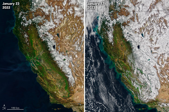
Instead, nine atmospheric river storms battered the state from Dec. 27 to Jan. 16, triggering flooding, mudslides, sinkholes — and, tragically, at least 20 deaths. Some areas received close to their annual precipitation in just those three weeks. Averaged over the entire state, the precipitation totaled 11.47 inches, according to the Weather Prediction Center of the National Weather Service. That’s nearly 50 percent of the precipitation the state receives in an entire water year.
And those 11.47 inches work out to an astonishing 32 trillion gallons of water.
The atmospheric rivers also pumped copious moisture into the Colorado River Basin, with many locations seeing their wettest or near-wettest conditions on record for January, according to the Colorado Basin River Forecast Center. In a tweet, the center noted that “if conditions hold through winter, we can expect above-average streamflow forecasts throughout the #ColoradoRiver Basin.”
But that’s a big “if.” And even above-average streamflow wouldn’t be enough to reverse the fortunes of a vast region of the West starved for water over the course of years. “To begin to alleviate long-term hydrologic drought and contribute to spring and summer runoff, snow needs to continue to accumulate during the winter,” notes a special drought status update published Jan. 24 by NOAA. Moreover, it will take above-average precipitation over the next three to five years, plus better management of water consumption, “to completely alleviate long-term hydrologic drought,” the update states.
All in all, the drenching we saw in late December through mid-January seemed much more like an El Niño, La Niña’s opposite. What happened?
A simple answer is that when it comes to weather, stuff just happens — La Niña be damned.
“Sometimes other processes can intervene and overwhelm the signal from La Niña,” says Marty Ralph, Director of the Center for Western Weather and Water Extremes at the Scripps Institution of Oceanography. “That’s how the atmosphere works.”
But what about the details? Just how did La Niña’s signal get overwhelmed? To understand that, it helps to consider these five things: different dimensions of time, a game of chance, a roiling cauldron, a butterfly, and us — specifically, the impact we’re having on the climate.
First off, just what is La Niña and how does it influence our weather?
In a nutshell, La Niña and El Niño comprise one of our planet’s most consequential climate phenomena: the see-sawing El Niño-Southern Oscillation, or ENSO. La Niña itself is characterized by cooler than normal sea surface temperatures along the equator in the Pacific Ocean. This is accompanied by changes to wind and storm patterns, including atmospheric rivers — long columns of moisture that can carry the equivalent of 15 times the average flow of water at the mouth of the Mississippi River.
“Atmospheric rivers impacting the North American West Coast typically occur in the wintertime,” says Marybeth Arcodia, an expert in climate variability at Colorado State University. So the fact that they occurred this winter is not unusual.
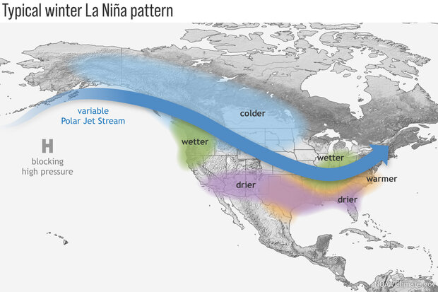
But one impact of La Niña is a tendency for a strong ridge of high atmospheric pressure to form over the northeast Pacific Ocean. This, in turns, shifts storm tracks northward, favoring wet winters in the Northwest and dry winters from roughly the southern half of California into the Southwest, across to Texas, and beyond. (For the northern half of California, there are typically equal chances for a dry or wet winter during a La Niña.)
Yet as 2022 transitioned to 2023, all of California got drenched. And that brings us to different dimensions of time.
La Niña occurs on a timescale that stretches over the course of entire seasons — and with this La Niña, three years. Meanwhile, “the flooding from these atmospheric rivers has happened in just a matter of weeks,” Arcodia observes.
Her point is that a climate phenomenon like La Niña works over a much longer period than individual storms, which happen day-to-day and week-to-week. In fact, for the first two years of this La Niña threepeat, much of California and the southwestern United States were starved of winter precipitation. But on the shorter timescale of a few weeks in December and January, individual weather events managed to punch through La Niña’s longer-term influence.
“If you have a La Niña ridge of high pressure off the West Coast, sometimes an atmospheric river can cut under it for a day or two and pummel Southern California,” Ralph says.
But in this case, of course, there was a parade of those rivers for three straight weeks. To delve more deeply into how this happened, let’s consider a simple game of roulette.
When played in a casino, you have a greater than 97 percent chance of losing a bet in roulette. But that doesn’t mean you can never win. If you had enough money to keep trying, sooner or later you’d probably cash in.
Similarly, just because the odds tilt against the southern half of California winning a lot of moisture during a La Niña winter doesn’t mean it will never experience a moisture win. The climate phenomenon comes with no guarantees, only odds. That point is driven home by the La Niña winter of 2016-2017, when all of the Golden State won the precipitation jackpot and went on to experience its third wettest year on record.
So, at a simple level, California’s experience during late December through mid-January is just one of those things that happens from time to time, due to an unlikely but entirely possible throw of the atmospheric dice. (Once again, stuff happens…)
But to answer the more complex question of just how short-term weather patterns ganged up to overcome the odds imposed by La Niña, let’s take a step back to consider the big picture — and how it resembles a pot of bubbling liquid.
Seen from space, rushing atmospheric rivers, whirling bomb cyclones, and blossoming supercell thunderstorms can leave the impression that the atmosphere we live in is indeed akin to a cauldron of roiling stew. And that’s not so far off the mark. From the point of view of physics, the atmosphere acts as a liquid, with the sun providing the flame to get things going. But even as we’re drenched, whipped, and often scared out of our wits by severe weather, we may well be unaware of features in the atmospheric cauldron that drive storms toward us.
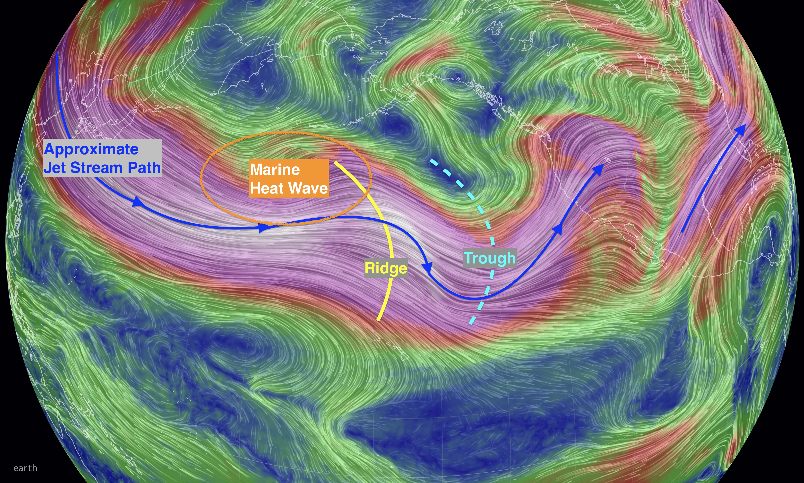
These drivers include the constant bubbling up and down of atmospheric pressure. When a high pressure area is born, it typically grows into an elongated shape — a ridge in the atmosphere — with winds circulating around it in a clockwise direction. After California’s onslaught of storms ended in January, a La Niña-like ridge of high pressure became ensconced along the U.S. West Coast, bringing fair weather and shunting rainfall far to the north. (Will it stay there? Keep reading…)
By contrast, an area of low pressure typically takes the form of trough — which is why meteorologists call it just that. In the Northern Hemisphere, winds around a low within a trough flow counterclockwise, often bringing stormy weather.
Ridges and troughs are outlined by the flow of the jet stream, a relatively narrow band of strong wind in the upper levels of the atmosphere. (There are actually multiple jet streams; I’m talking about what’s known as the “polar” jet stream.)
The pattern is akin to ocean waves. And like ocean waves, the ridges and troughs normally aren’t stationary. Although sometimes they can become stuck, most of the time, they move, just like ocean waves, progressing slowly from west to east, dissipating and reforming, all the way around the globe. (The flow of air in the jet stream itself is much faster than the stately procession of the ridges and troughs themselves.)
These large-scale features don’t just look like waves. They are waves — in the atmospheric cauldron. Scientists call them Rossby waves, after meteorologist Carl-Gustaf Arvid Rossby, who first identified them.
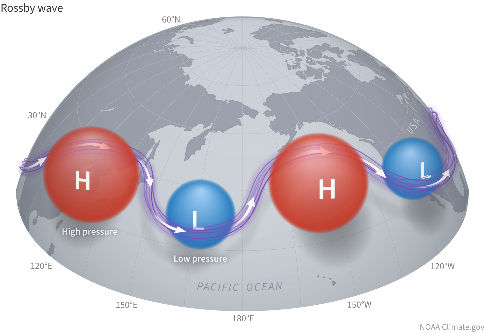
“Rossby waves and the jet stream are two separate, but intimately connected, entities,” says Breanna Zavadoff, an atmospheric scientist at the University of Miami. As the waves form, grow, shrink, move, and reform, they interact with the jet stream, affecting where it is positioned and how wavy it is, thereby shaping the weather we experience.
During winter in La Niña years, these interactions tend to produce a wavier pattern than in neutral years. And in the Pacific, that wavy pattern often results in the persistent ridge of high pressure over the northeastern part of the ocean. Combined with other factors, this can help funnel very moist winds from the subtropics near Hawaii into atmospheric rivers aimed at the Pacific Northwest.
But with the proverbial flap of a butterfly’s wings, something else can happen.
As you might imagine, a bubbling up or down of pressure can occur here, there, or anywhere, either by chance, or possibly even due to us. (More about that in just a bit.) And with just that small change in initial conditions, a chain of events can be touched off in the atmosphere that eventually has big effects thousands of miles away.
Something like that happened a few weeks before California’s battering by atmospheric rivers: a bubbling up of strong thunderstorm activity in the Indian Ocean. It was part of a phenomenon called the Madden-Julian Oscillation, or MJO, and Ralph believes it played a major role in what happened.
Whereas La Niña, and its opposite, El Niño, are stationary, and occur on a timescale of entire seasons, MJO moves, and its impacts occur more on a weekly timescale. It consists of a disturbance of clouds, rainfall, winds, and pressure changes that moves eastward in the tropics, circling the entire globe in about 30 to 60 days, on average.
The storminess Ralph observed in the Indian Ocean was part of this pattern. As it moved east into the tropical Pacific, thunderstorm activity caused water vapor to rise high into the atmosphere. As the water vapor cooled at altitude and condensed to form billowing clouds, large amounts of latent heat were released.
“This is a massive forcing of the atmosphere in a manner that sends Rossby waves to the northeast in the Pacific Basin,” Ralph says. And as we’ve seen, these waves — troughs and ridges — play a leading role in the weather we experience. That includes where atmospheric rivers, or ARs, make landfall.
But the MJO phenomenon doesn’t always result in the southern part of California getting drenched. Other factors play a role too, and the interplay is complex. Ralph and his colleagues at Scripps have developed a tool designed to tease apart the details of that interplay and thereby enable forecasters to better predict what might happen when an MJO is in place.
“We’re just kicking the tires on it right now,” he says. The goal is to use the tool “to determine whether the odds are tilting toward ARs two to three weeks ahead.”
In early January, after the MJO storminess moved from the Indian Ocean into the tropical Pacific, a now infamous bomb cyclone erupted and moved toward California. “Its minimum air pressure plummeted by about 3 percent in 24 hours, signifying a vacuum-like ingestion of air… resulting in strong inward winds,” wrote Washington Post meteorologist Matthew Cappucci and science journalist Diana Leonard at the time.
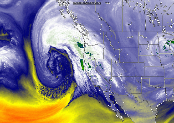
This vacuuming in of air by the storm happened in a trough bounded by a very big downward dip of the jet stream that wound up ideally positioned to direct rivers of moisture from the subtropics into California. In subsequent weeks, new storms formed and helped direct yet more atmospheric rivers over the state.
The eastward-moving disturbance of the MJO cited by Marty Ralph may not have been the only factor at play. As California was getting hammered, Jennifer Francis, Senior Scientist at the Woodwell Climate Research Center, was taking note of another phenomenon far from California: a sprawling area of abnormally warm surface water called a “marine heatwave” in the northern Pacific, south of Alaska’s Aleutian Islands. She also noted that the typical wavy pattern of the jet stream during a La Niña was not in place.
The jet stream was flowing straight east from Japan at the time. “But when it hits the heatwave area, it buckles,” Francis said in an email message. “A ridge forms over the heatwave, and then a trough forms downstream,” to the east. This pattern persisted, with the trough “creating the parade of storms striking the U.S. west coast.”
Climate change may well have something to do with this. Scientists recently discovered a pool of warming water in the northern Pacific sprawling across more than 1.1 million square miles — an area equivalent to about a third of the contiguous United States. Using observations and computer modeling, the researchers investigated what was behind this “warming pool.” They concluded that increasing greenhouse gas levels in the atmosphere have been a key cause. Another human influence — this one laudable — played a role too: decreases in aerosol pollution from industry and vehicles.
The warming pool has had significant impacts on the region. For example, over the last two decades, summers have averaged 1.5 °C warmer and 37 days longer, according to the researchers. They also found that the warming pool has been encouraging the formation of marine heatwaves — along with weather-altering ridges of high atmospheric pressure above them — like the one noted by Jennifer Francis.
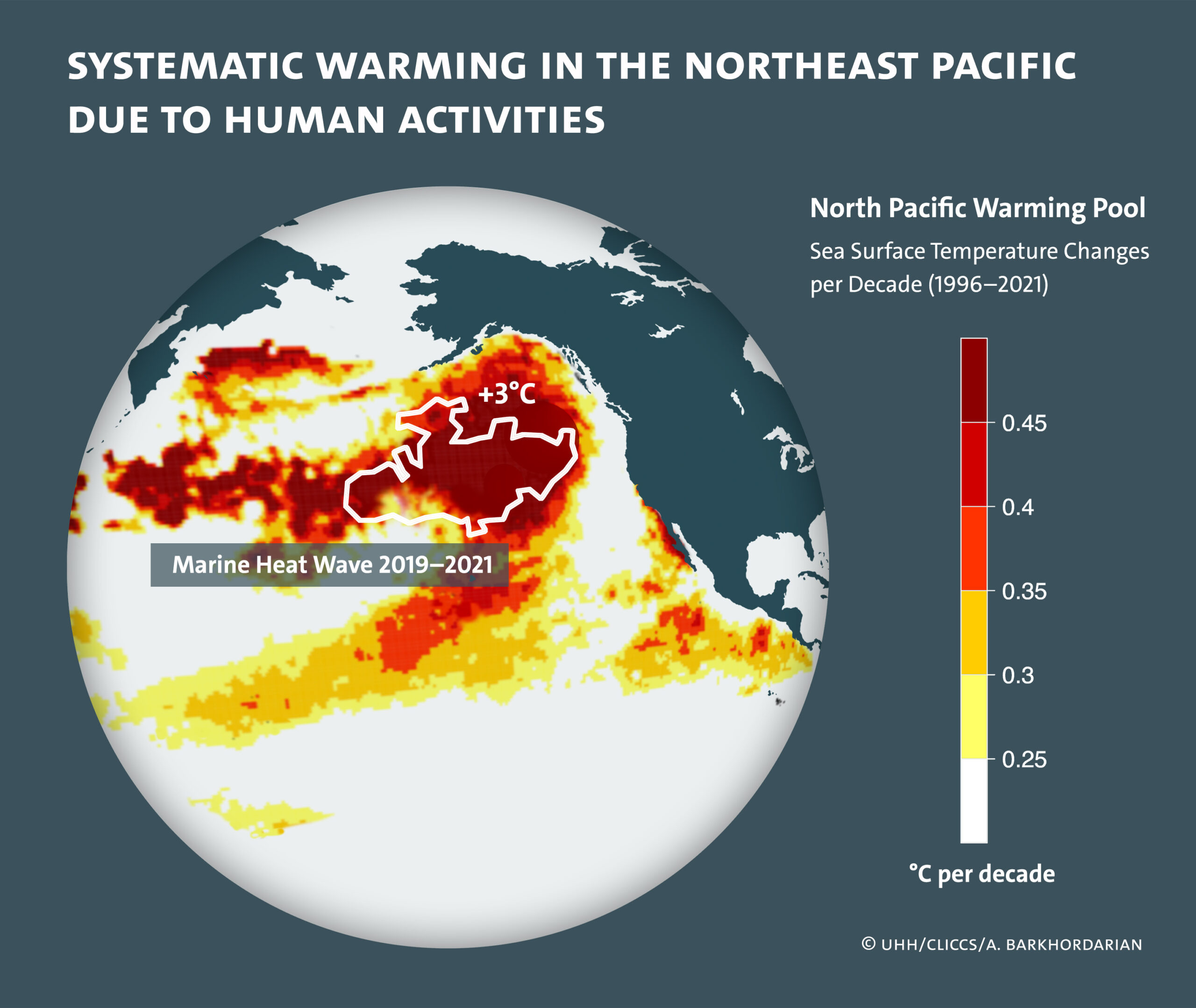
With greenhouse gas levels in the atmosphere continuing to rise, we can well imagine what’s to come. “This warming pool will continue to increase the water temperature in the future, increasing both the frequency and intensity of local marine heatwaves,” says lead author Armineh Barkhordarian of the University of Hamburg, quoted in a release.
Francis agrees: “I think ocean heatwaves will only increase in frequency, intensity, and spatial extent as we continue to augment concentrations of greenhouse gases.”
Given what we’ve seen this year and in the past from marine heat waves, it’s plausible that weather impacts could grow even more intense as they worsen. What might that mean for California? It’s difficult to say, according to Francis. So many different factors are at play that it will take further research to tease out what the impacts might be, and where and when they might occur.
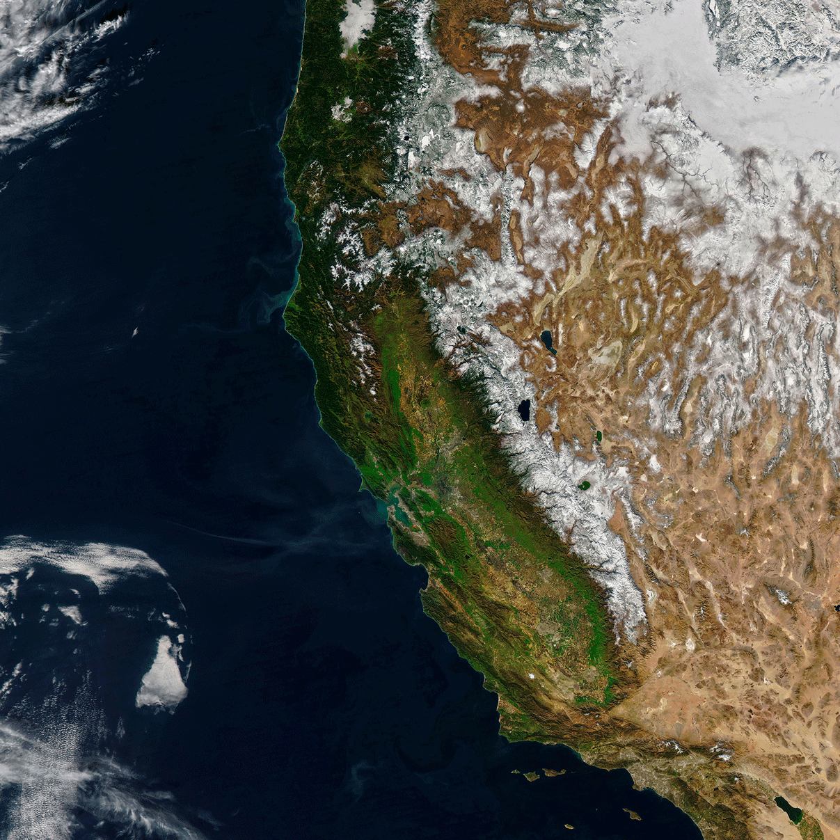
Regardless, what happened in December and January does provide some solace: The intensity of California’s drought has eased somewhat, depleted reservoirs have gotten desperately needed inflows, and a healthy snowpack has built up in the Sierra Nevada Range, and to the east. Even so, California’s water woes continue. As of Jan. 17, more than 90 percent of the state was still in drought.
It’s possible that the current dry pattern along the West Coast will continue, and conditions will look a whole lot more like La Niña in the remaining months of winter and heading into spring. That would undercut gains that California and parts of the Colorado River Basin have made so far. There’s ample precedent for this. In December 2021, parts of the Sierra experienced record snowfall, despite La Niña. But then conditions took a radical turn, with the driest January, February, and March in more than 100 years.
At the same time, there is a glimmer of hope for a different outcome. “There are some very preliminary hints of a shift,” with increased activity of atmospheric rivers coming in February, Ralph says. The caveat is that when looking ahead more than about a week, uncertainties mount, so the shift may not pan out. “But the odds are in favor of getting back into a wet mode.”
Let’s hope it happens more gently this time.
The Water Desk’s mission is to increase the volume, depth and power of journalism connected to Western water issues. We’re an initiative of the Center for Environmental Journalism at the University of Colorado Boulder. The Water Desk launched in April 2019 with support from the Walton Family Foundation. We maintain a strict editorial firewall between our funders and our journalism.


