In November 2018, Marble Town Manager Ron Leach received a letter that he said was a wake-up call.
The letter was a notice from the Colorado Division of Water Resources that the town’s water rights had been “out of priority” for four weeks the previous August and September because of a call placed by a senior water-rights holder downstream on the Crystal River.
During drought years — and 2018 was an extreme one, with the Crystal running at less than 5% of average after peaking in May, several weeks earlier than usual — junior water-rights holders may have to curtail their water usage until the senior call is satisfied.
“Drought and water supply have been on people’s minds for a long time around here, but we’ve never gotten a letter like that,” Leach said.
The letter urged the Marble Water Company — the private nonprofit entity that delivers water to the town’s approximately 150 residents and a handful of businesses — to create a plan of augmentation, which is an alternate source of water such as a storage pond. Without augmentation, the letter warned, a call could subject Marble to a cease-and-desist order on its municipal water wells.
Several other neighborhoods that get their water from the Crystal also narrowly dodged a bullet that August. The same call put more than 40 homes in Carbondale at risk of not having water, according to Town Manger Jay Harrington.
“Firefighting capability was an issue, too,” Harrington said. “That’s where we had to scramble.”
Carbondale officials were able to make an emergency arrangement with another senior water-rights holder on the Crystal to temporarily borrow water to supply the homes. And they quickly set in motion plans to avoid the situation in the future. In essence, the town is shifting the supply for some of its water needs from the heavily irrigated Crystal to the more reliable Roaring Fork, as the town has three wells that draw from the Roaring Fork aquifer, and has the option to develop more wells. The town also owns 500 acre-feet of water in Ruedi Reservoir it can use to offset its well depletions from the Roaring Fork aquifer.
Up in Marble, Leach doesn’t have multiple, redundant water supplies to serve his constituents. Noting that Marble’s water supply barely exceeds peak summer demand, an engineering firm’s preliminary recommendation was for an 11-acre-foot reservoir, which would require 3 to 4 acres of flat ground.
“The town of Marble doesn’t have cash to do anything like that,” said Leach, who added that space in the constrained mountain valley might also be a hurdle. “There’s no easy solution.”
Still, Leach is confident something will get figured out — a state-funded water study of the Crystal was recently approved, he said — but a very dry 2020 has underscored that the water issue is not going away anytime soon. During what’s now widely accepted as a two-decade-long drought in the Colorado River basin, temperatures have risen, summer rains can’t be relied on and streamflows have dropped, with earlier peak flows sometimes leaving little water in streams by late summer. The state’s letter to Marble noted that “it is reasonable to assume that this administration scenario could happen more frequently in the future.”
To those who deal with water day to day, there’s no question climate change is here and its impacts are being increasingly felt in the summer.
“It all starts with climate change — that’s the big picture,” said Leach. “What’s happening in Marble, this is the micro-example.”
Other Roaring Fork municipalities are also grappling with climate-caused water supply issues. The city of Aspen, which provides municipal water from free-flowing Maroon and Castle creeks and has seen Stage 2 water restrictions enacted two of the past three summers, is creating a 50-year water plan — driven in part by climate-change impacts — that may include expanded water storage. In Basalt, the 2018 Lake Christine Fire came close to cutting power supplies, which could have caused the failure of pump stations that deliver water to users. And after one of Glenwood Springs’ water sources was temporarily shut down during this summer’s Grizzly Creek Fire, debris, ash, mudslides and fire retardant pose lingering hazards.
“We need to continually work on our water systems as we continue to adapt to climate change,” said Harrington. “We are going to have to figure out how to slow it down, but in the meantime, we need to take climate change into our planning.”
The heat is on
Warming temperatures, linked to increased global greenhouse-gas emissions, are the catalyst that impacts other key conditions in the mountains, including lower snowpacks and streamflows; earlier snowmelt and runoff peaks; more precipitation in the form of rain than snow; more frost-free days; and lower soil moisture.
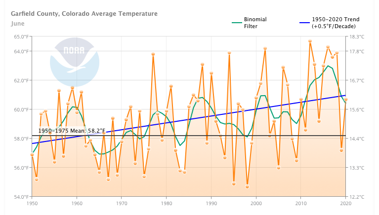
As average temperatures rise in all seasons, heat waves like the one that gripped Colorado during the summer of 2020 are becoming more common. According to the National Oceanic and Atmospheric Administration, average temperatures from May to October in Pitkin and Garfield counties have risen more than 2 degrees Fahrenheit since the 1950s. Some months are warming faster than others. In Pitkin County, June, July and September have warmed by nearly 3 degrees since 1950, while in Garfield County, June and September are 3.5 degrees warmer.
A 2019 report prepared for the town of Carbondale hints that warming has accelerated in the 21st century, with three of the five warmest years on record over the past decade. Also, this past August was the hottest on record for Colorado. In Aspen, the average temperature of 66.9 degrees in August was 5.6 degrees above normal.
The Roaring Fork Valley sits on the eastern edge of the largest hot spot in the Lower 48, according to a Washington Post project that analyzed data to identify areas that have warmed by more than 2 degrees Celsius (3.6 degrees Fahrenheit) — double the global average — since the industrial revolution.
Noting that 12 of the hottest 14 years in western Colorado have occurred in the past 18 years, Colorado River Water Conservation District general manager Andy Mueller said at a recent conference that “the biggest change in temperatures has been occurring within our district and eastern Utah, which is a real problem when you look at the fact that we’re the area that produces the most-significant amount of water in the entire rivershed.”
Scientists are in broad agreement that as long as greenhouse-gas emissions continue to rise — or even level off — temperatures will follow suit.
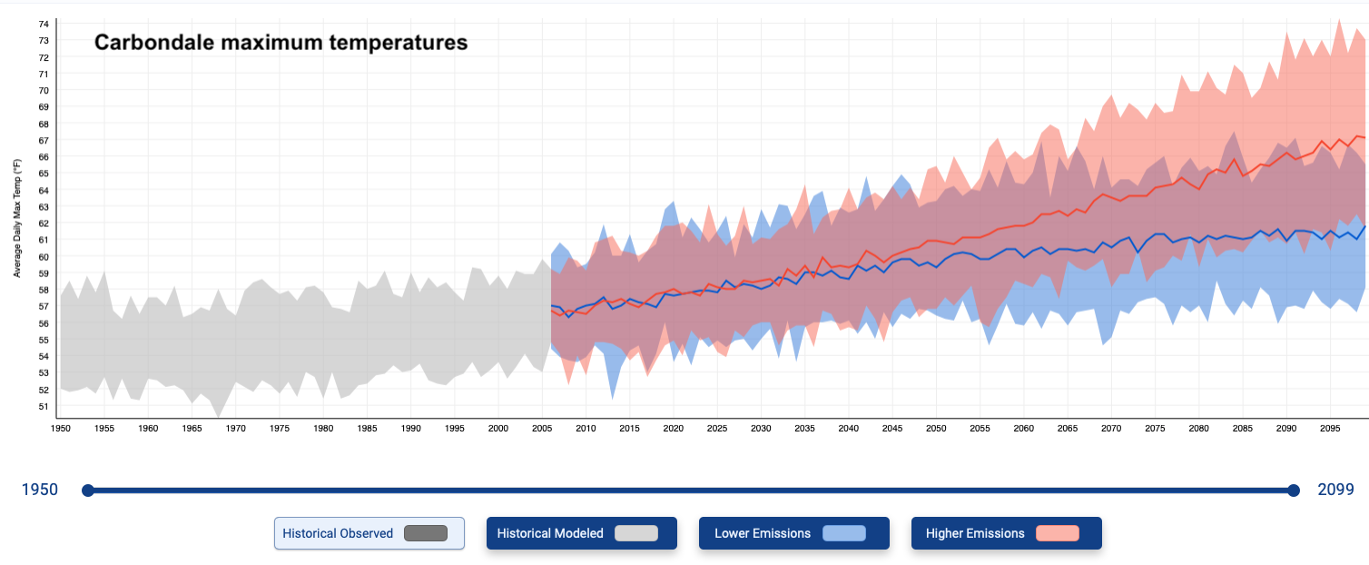
Projections for the region range depending on emissions scenarios, but nearly all of them forecast at least another rise of average temperatures of 3 degrees Fahrenheit by mid-century and a rise of approximately another 10 degrees by the end of the 21st century. To put this into perspective, a warming Aspen could have the climate of Carbondale or Glenwood Springs, while Glenwood would look and feel like Grand Junction in a few decades.
The atmosphere taketh away
Local summer precipitation trends are less clear. Monsoon rains — or the lack thereof — drive great swings year to year in summer precipitation, which is usually dwarfed, in terms of volume, by winter precipitation in the form of snow. Historical data shows no clear trends. A report prepared for the town of Carbondale says that average precipitation in the 20th century and since 2000 are about the same.
Still, the summer of 2020 capped a decade of multiple dry summers. Colorado this year saw its third-driest April-July period, according to the National Weather Service, and the 2.5 inches of precipitation Aspen had from June through August was nearly 2 inches below normal. It was the fourth summer in a row with below-average precipitation and the driest in that stretch — even the summer of 2018 saw more rain.
Precipitation projections are also not very clear — although some experts suggest that precipitation could decrease in the summer and increase in the winter. But whether there’s a little more or a little less rain and snow in the future — and the latest models show a long-term decline in the Colorado River Basin — scientists say it doesn’t matter.
“There’s more uncertainty in how much precipitation is going to change and less uncertainty about how much temperature is going to change,” said hydrology expert Julie Vano, who is research director at Aspen Global Change Institute. “And the effect of just having warmer temperatures means more water is leaving the system.”
Jeff Lukas, a researcher on NOAA’s Western Water Assessment team, put it this way: “A warming atmosphere is a thirstier atmosphere.” In the Roaring Fork Valley, he said, only about a third of all precipitation makes it into streams and rivers; the other two-thirds is reclaimed by evapotranspiration, which is the combination of evaporation from surfaces and what plants absorb then release. Since evapotranspiration is driven in large part by temperature, as temperatures rise, the amount of water in rivers declines.
“The atmosphere giveth and the atmosphere taketh most of it away,” said Lukas. “Warming is the factor — across all seasons and all water-cycle processes — that draws moisture away from the land surface before becoming runoff.”

The flow is low
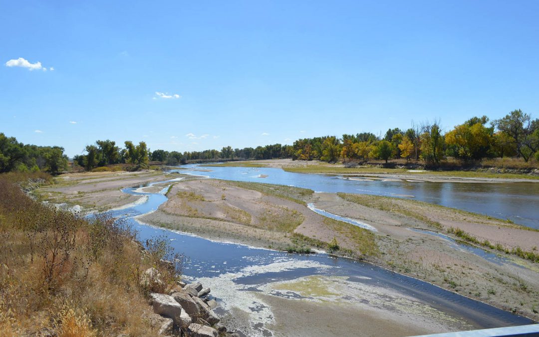
After more than a century of diversions, dams, storage projects and other stream manipulations, it’s complicated to calculate trends in natural streamflow, the term for the amount of water in a river. But streamflow, also called runoff, has perhaps the most direct effect on water availability. And trends are not looking good.
Since 2000, according to a recent report, the average annual volume of water in the upper Colorado River basin, from its headwaters to Lees Ferry (just below Lake Powell in Arizona), has dropped 15% below the long-term average from 1906 to 2019. Published last April, the Western Water Assessment’s “Colorado River Basin Climate and Hydrology State of the Science” report synthesizes all of the recent studies and data on this massive topic. The report’s authors compiled ever-increasing evidence about how rising temperatures are contributing to less water in the Colorado River, which supplies the needs of 40 million people. Although precipitation is still an important factor, some research shows that warming accounts for up to half of the water loss. One study calculated that every 1 degree Fahrenheit of warming decreases runoff by 7.5%.

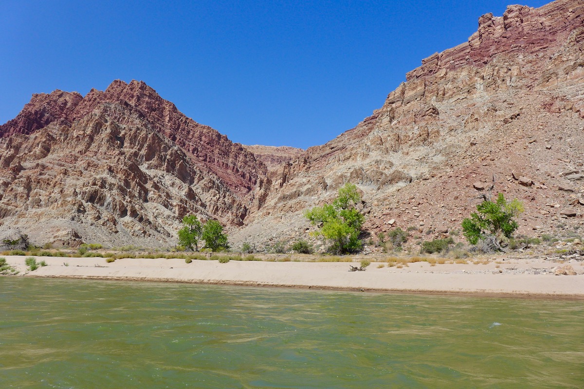
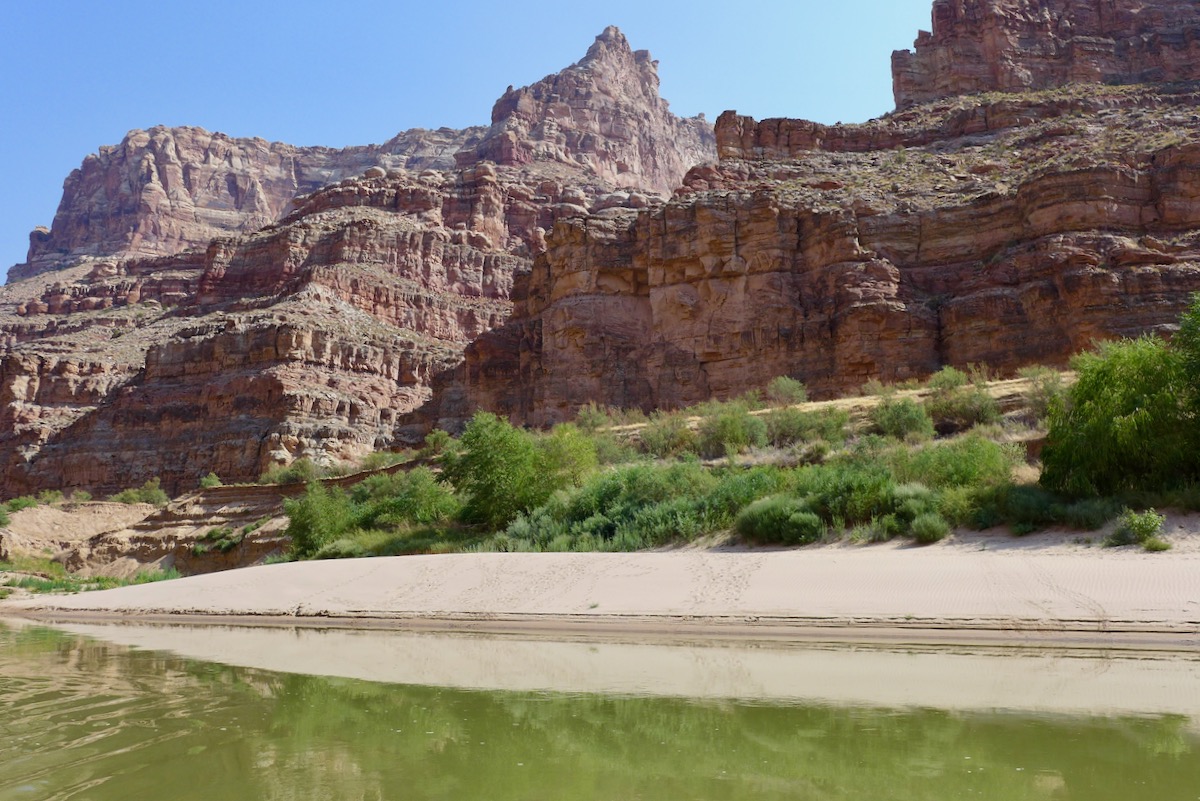
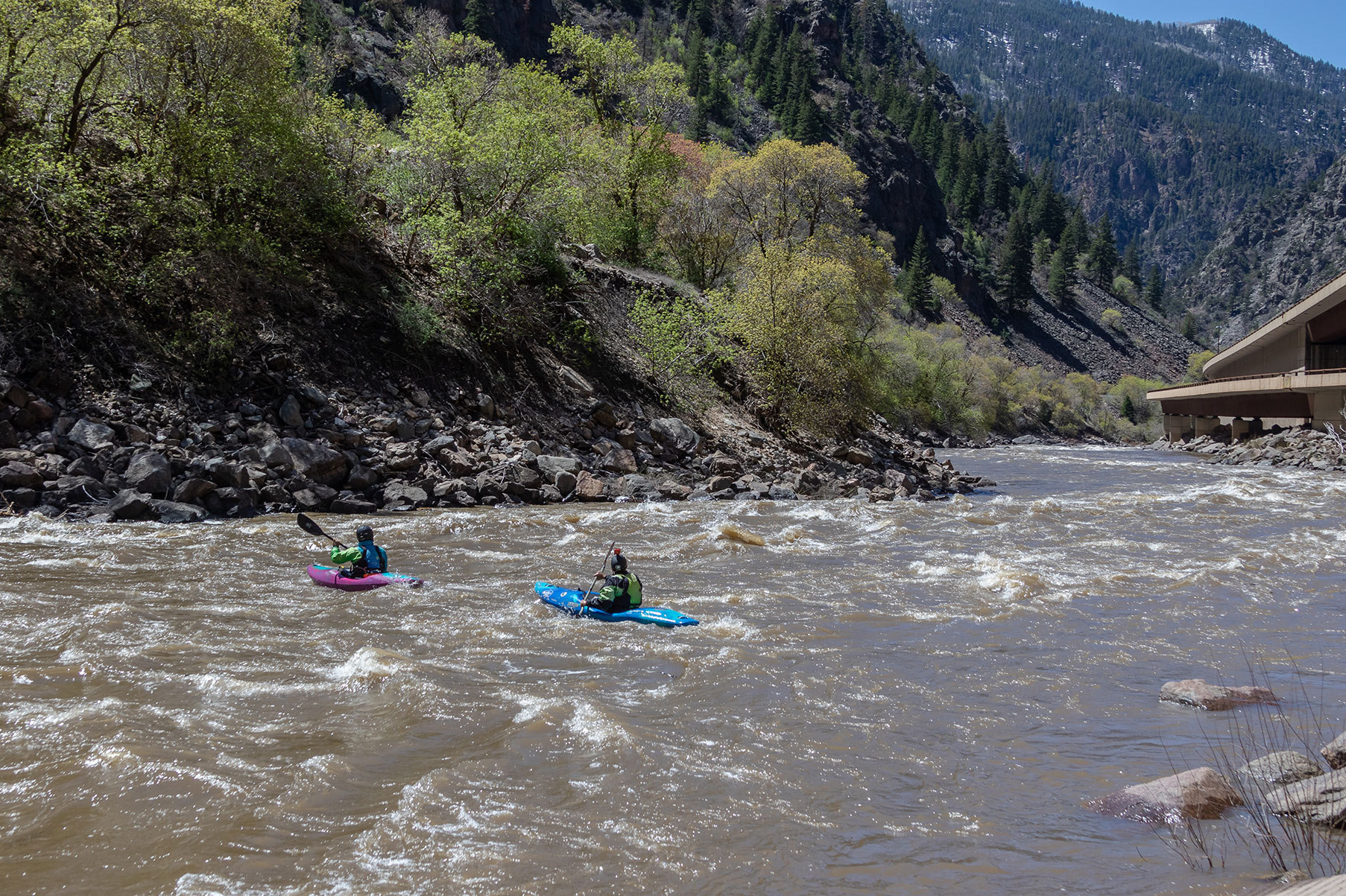
Declining streamflows are also found up the Colorado’s tributaries. Taking into account water that would’ve been in the stream if it weren’t for diversions and ditches, Lukas calculated that between 2000 and 2018, the Roaring Fork River at Glenwood Springs had 13% less water than the 20th-century average. Analyzing data on the Crystal River near Redstone, he calculated a 5% drop in annual mean streamflow since 2000, compared with the latter half of the 20th century, but a 10% decline during drier years.
In that same analysis of the Crystal, Lukas found that the date of peak streamflow had shifted one week earlier since 2000: from reliably arriving in June to sometimes coming in May. Multiple studies across the Colorado basin have similarly calculated a one- to four-week earlier runoff — which means that high-country snowpacks are melting earlier, so that the highest volume of snowmelt rushing down those streams is coming earlier in the spring.
But an above-average snowpack doesn’t mean an equivalent runoff, as this past year has shown. After a good winter followed by a warm, dry spring and summer, just 55% of the upper Colorado’s runoff made it into Lake Powell.
“The expectation that this amount of snow leads to this amount of runoff — we’re just not seeing as much as we did in the past,” said Vano, the hydrology expert.

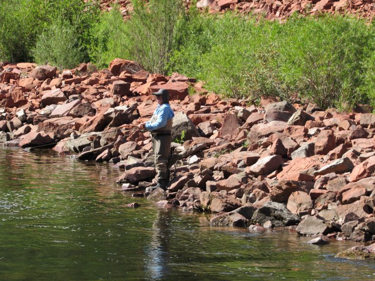
Earlier peak runoff and lower flows mean less water (especially in drought years) in late summer and early fall, a critical time for irrigation, recreation and natural systems. From late July through October, the Crystal River upstream from Carbondale has been flowing below half of average, lower than the instream flow water right held by the state for that stretch of river — but since irrigation rights are senior to the conservation right, there’s often no recourse. For example, that is what happened in August on another tributary of the Roaring Fork, when the Colorado Water Conservation Board, which holds 1,700 instream-flow rights throughout the state, requested administration of its instream rights on Hunter Creek, acknowledging that it would likely be “a futile call.”
“A river is not a river without water in it,” said Heather Tattersall Lewin, science and policy director for the Roaring Fork Conservancy.
As with higher temperatures, declining streamflows and earlier runoff are certain into the future, but how much will depend on emissions. A 2006 report by the Aspen Global Change Institute calculated that by 2030, peak runoff for the Roaring Fork River at Woody Creek will occur in May rather than June. And by 2100, the lingering snowpack we see on the high peaks in June will no longer exist, which means less water in the stream all summer. Add in increased demand from growth and diversions, and future Roaring Fork River flows through Aspen could go below required instream-flow levels for nine months of the year.
Downstream in Glenwood Springs, the Roaring Fork’s late summer flows could decline by 30% to 50% by 2070, according to a 2018 analysis by Lukas.
“Changes to water will touch nearly everything,” he said. “All the risk is on the dry side.”
The underlying factor
Another important factor to consider is one we don’t really see: soil moisture.
One of the metrics used to calculate drought severity, soil moisture has been studied locally by the Aspen Global Change Institute since 2013. This short period of record may preclude discerning any trends about whether local soils are getting drier, but the data does show how moisture levels can have a domino effect season to season.
Elise Osenga, community science manager for the institute, likens the soil to a sponge. A dry sponge, like dry soil, absorbs more water than when it’s wet, while a wet sponge, like saturated soil, lets the excess run off. The water that the soil doesn’t absorb goes into streams.
“Climate change is more likely to dry soils in the spring,” said Osenga, who explained that peak snowmelt and peak soil saturation happen around the same time in the mountains. “When that happens, we’ll see soils dry earlier in the summer and become more dependent on summer rain — which is problematic when we don’t get those rains.”
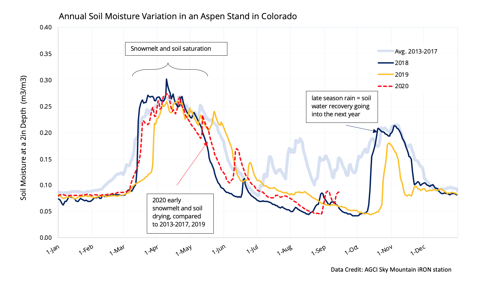
Each of the past three years, soil moisture in Pitkin County has dipped well under the 2013-2017 average for most of the summer. The drought year of 2018 saw an early snowmelt and soil drying, but fall rains helped soils recover, auguring well for the next year. Most remember the record snows of late winter and spring of 2019, but the lack of rain that summer dried things up. And 2020 largely mirrored 2018, although 2020 saw slightly better soil moisture until late summer.
This year, things may have cooled off since August, but drought conditions have worsened, with all of Colorado, as of Oct. 22, in some form of drought and 78% of the state in extreme or exceptional drought. This doesn’t bode well for spring.
With soil moisture, said Osenga, “what happens in September and October is actually really interesting, because it plays a big role in determining whether we start the next spring already at risk of a drought versus in better shape.”
With multiple dry years over the past two decades, some scientists are wondering if we’re entering a period of megadrought, which hasn’t been seen in several hundred years.
“It might be a combination of natural variability plus climate change — a double whammy,” said Vano.
No single drought is evidence of climate change, Lukas said, but “what we’re seeing since 2000 is that climate change is stacking the deck. We’re more prone to the deep droughts, the ones that sneak out of left field like in 2020.”
And even with good planning, that’s sure to make water managers in Marble and Carbondale and throughout the Colorado River basin nervous.
“We do see changing conditions, whether attributable to increased demand/development by water users, drought or long-term climate change,” wrote Colorado water commissioner Jake DeWolfe in an email. “Any of them leads to the same problem: a shortage of water. We are involved in planning for the future likelihood that we will need to limit, if not curtail, uses in Colorado to meet the needs of downstream states.”
An abridged version of this story ran in The Aspen Times on Oct. 30.
The Water Desk’s mission is to increase the volume, depth and power of journalism connected to Western water issues. We’re an initiative of the Center for Environmental Journalism at the University of Colorado Boulder. The Water Desk launched in April 2019 with support from the Walton Family Foundation. We maintain a strict editorial firewall between our funders and our journalism. The Water Desk is seeking additional funding to build and sustain the initiative. Click here to donate.