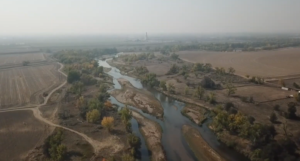
The Colorado River divides Glenwood Canyon slurry on the ridge from the Grizzly Creek Fire on Monday, August 24, 2020. (Kelsey Brunner/The Aspen Times)
By Heather Sackett
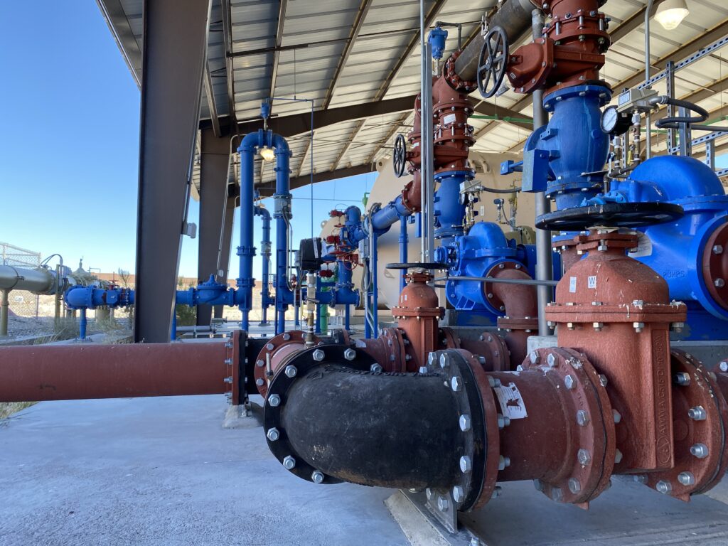
Glenwood Springs has received approval for a loan of up to $8 million from the state to upgrade its water system to deal with the impacts of this past summer’s Grizzly Creek Fire.
The Colorado Water Conservation Board approved the loan for system redundancy and pre-treatment improvements at its regular meeting Wednesday. The money comes from the 2020 Wildfire Impact Loans, a pool of emergency money authorized in September by Gov. Jared Polis.
The loan will allow Glenwood Springs, which takes most of its municipal water supply from No Name and Grizzly creeks, to reduce the elevated sediment load in the water supply taken from the creeks as a result of the fire, which started Aug. 10 and burned more than 32,000 acres in Glenwood Canyon.
Significant portions of both the No Name Creek and Grizzly Creek drainages were burned during the fire, and according to the National Resources Conservation Service, the drainages will experience three to 10 years of elevated sediment loading due to soil erosion in the watershed. A heavy rain or spring runoff on the burn scar will wash ash and sediment — no longer held in place by charred vegetation in steep canyons and gullies — into local waterways. Also, scorched soils don’t absorb water as well, increasing the magnitude of floods.
The city will install a sediment-removal basin at the site of its diversions from the creeks and install new pumps at the Roaring Fork River pump station. The Roaring Fork has typically been used as an emergency supply, but the project will allow it to be used more regularly for increased redundancy. During the early days of the Grizzly Creek Fire, the city did not have access to its Grizzly and No Name creek intakes, so it shut them off and switched over to its Roaring Fork supply.
The city will also install a concrete mixing basin above the water-treatment plant, which will mix both the No Name/Grizzly Creek supply and the Roaring Fork supply. All of these infrastructure improvements will ensure that the water-treatment plant receives water with most of the sediment already removed.
“This was a financial hit we were not anticipating to take, so the CWCB loan is quite doable for us, and we really appreciate it being out there and considering us for it,” Glenwood Springs Public Works Director Matt Langhorst told the board Wednesday. “These are projects we have to move forward with at this point. If this (loan) was not an option for us, we would be struggling to figure out how to financially make this happen.”
Without the improvement project, the sediment will overload the city’s water-treatment plant and could cause long, frequent periods of shutdown to remove the excess sediment, according to the loan application. The city, which provides water to about 10,000 residents, might not be able to maintain adequate water supply during these shutdowns.
According to the loan application, the city will pay back the loan over 30 years, with the first three years at zero interest and 1.8% after that. The work, which is being done by Carollo Engineers and SGM, began this month and is expected to be completed by the spring of 2022.
Langhorst said the city plans on having much of the work done before next spring’s runoff.
“Yes, there is urgency to get several parts and pieces of what the CWCB is loaning us money for done,” he said.
The impacts of this year’s historic wildfire season on water supplies around the state was a topic of conversation at Wednesday’s meeting. CWCB Director Rebecca Mitchell said her agency has hired a consultant team to assist communities — through a watershed restoration program — with grant applications, engineering analysis and other support to mitigate wildfire impacts.
“These fires often create problems that exceed impacts of the fires themselves,” she said. “We know the residual impacts from these fires will last five to seven years at minimum.”
Aspen Journalism is a local, nonprofit, investigative news organization covering water and rivers in collaboration with The Glenwood Springs Post-Independent and other Swift Communications newspapers. This story ran in the Nov. 19 edition of the Glenwood Springs Post-Independent and the Nov. 19 edition of Aspen Journalism.
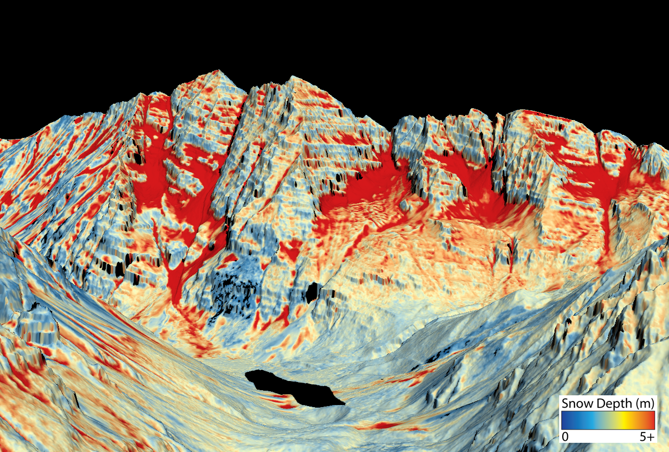
This map shows the snowpack depth of the Maroon Bells in spring 2019. The map was created with information from NASA’s Airborne Snow Observatory, which will help water managers make more accurate streamflow predictions. Source: Jeffrey Deems/ASO, National Snow and Ice Data Center
By Heather Sackett
Front Range water providers are hoping to expand a program that uses a new technology they say will revolutionize water management in Colorado. But for now, the expensive program isn’t worth it for smaller Western Slope water providers.
The Northern Colorado Water Conservation District is seeking state grant money to expand the Colorado Airborne Snow Observatory program. The ASO program uses remote-sensing lasers on airplanes known as LiDAR, which stands for light detection and ranging, to precisely measure snow depth and density.
The technology creates a much clearer picture of how much water is contained in the snowpack and has been used in pilot studies in the Gunnison River basin and for Denver Water.
But these flights have been scattered and lack consistent funding. A geographically expanded program with consistent funding would revolutionize water management in Colorado, according to the grant application.
“This technology is kind of a no-brainer when it comes to helping us understand what water we have to work with each year,” said Laurna Kaatz, the climate science, policy and adaptation program manager for Denver Water. “We know ASO adds value and is kind of the game-changer in water management.”
Denver Water, which provides water to 1.4 million people along the Front Range, is the ASO expansion project manager, while Northern Water is the fiscal agent. The Colorado, South Platte, Metro, Gunnison and Arkansas basin roundtables have each committed $5,000 toward the project.
SNOTEL limitations
Important data points that water managers and streamflow forecasters use for measuring snowpack — and the water contained in that snowpack, known as snow-water equivalent (SWE) — are snow-telemetry (SNOTEL) sites, a network of remote sensing stations throughout Colorado’s mountainous watersheds that collect weather and snowpack information. But they provide just a snapshot of conditions at one location.
“A large amount of SWE is in that high-elevation snow band, which doesn’t get captured by the SNOTEL program,” said Steve Hunter, utilities resource managers for the city of Aspen.
In the spring of 2019, Denver Water learned just how valuable ASO technology is in predicting runoff. Data from a June ASO flight showed there was about 114,000 acre-feet of water in the snow above Dillon Reservoir, Denver Water’s largest storage pool, even though SNOTEL sites, at about 11,000 feet, registered as melted out already. The water provider increased outflows from Dillon so they could make room for the coming snowmelt and avoid downstream flooding.
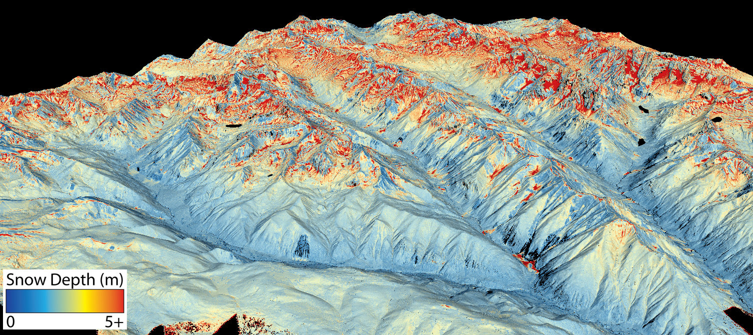
This map shows the snowpack depth of Castle and Maroon valleys in spring 2019. Colorado water managers are hoping to expand NASA’s Airborne Snow Observatory program with state grant money, which will help water managers make more accurate streamflow predictions. Source: Jeffrey Deems/ASO, National Snow and Ice Data Center
Expensive technology
ASO technology was developed by NASA and researchers at the National Snow and Ice Data Center at the University of Colorado Boulder. But the technology is expensive — between $100,000 and $200,000 per flight, according to Kaatz — and still not worth it for smaller Western Slope municipal water providers who don’t have to carefully coordinate the operation of large reservoirs.
The city of Aspen and the Eagle River Water & Sanitation District are part of the collaborative workgroup helping to create the ASO program expansion plan. Other entities include Colorado Springs Utilities, city of Fort Collins, city of Boulder, city of Greeley, Thornton Water, Pueblo Water, Aurora Water, city of Westminster, Ruedi Water Power and Authority, and the Colorado River Water Conservation District.
Hunter said more data is better when it comes to managing Aspen’s water supply, which comes from Castle and Maroon creeks. The city is trying to install a SNOTEL site and another stream gauge in its watershed. Hunter said the collaborative workgroup has also been exploring ways to sustainably fund an expanded ASO program.
“Airborne measurements of both snow depth and density to come up with your SWE is a great alternative, but it’s cost prohibitive,” Hunter said. “If they have this great technology but nobody can use because nobody can afford it, that doesn’t help anybody.”
Water managers for Eagle River Water & Sanitation District, which supplies water to the Vail Valley, said that although they are participating in the workgroup meetings and find the science interesting and useful, the expense is not something they can bite off right now. Their reservoirs are small and mostly used for augmentation, not to supply municipal water.
“I think there’s value in the whole system and understanding the water that’s available,” said Len Wright, the senior water resources engineer for Eagle River Water & Sanitation District. “But we don’t have anything that would justify the expense right now.”
Northern Water and Airborne Snow Observatories, Inc. will each contribute $5,000 worth of in-kind services to the project. Also, Denver Water will contribute $10,000 in-kind and the collaborative workgroup will give $24,000 of in-kind services. The Colorado Water Conservation Board is being asked for $20,000 from the statewide Water Supply Reserve Fund account and is scheduled to consider the grant application at its March meeting.
Aspen Journalism is a local, nonprofit, investigative news organization covering water and rivers in collaboration with The Aspen Times and other Swift Communications newspapers. This story ran in the Dec. 5 edition of The Aspen Timesand the Dec. 7 edition of Aspen Journalism.
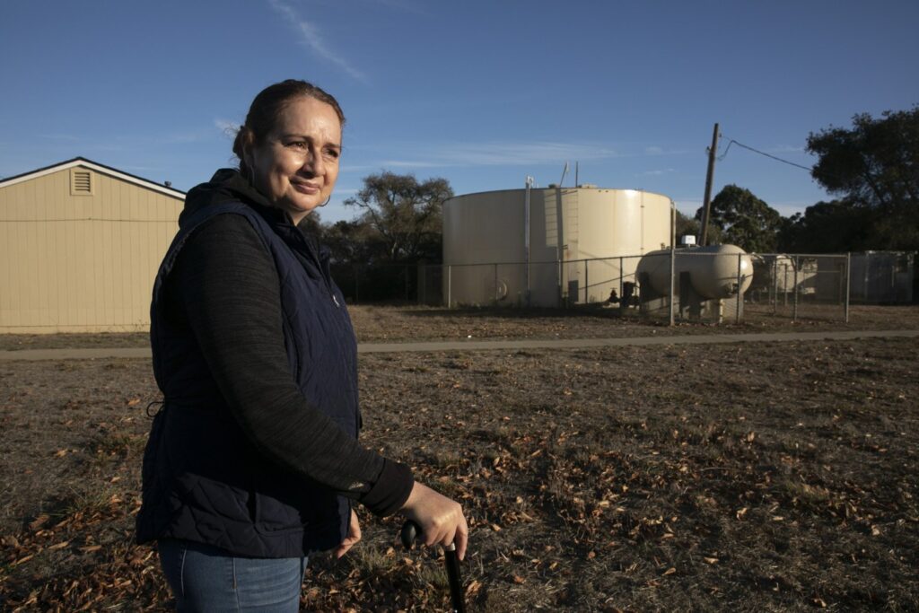
A water tank serving Buena Vista Migrant Center near Watsonville stores water from a well that exceeds state guidelines for a chemical called PFOA. The wells contain levels as high as 13 parts per trillion; the state’s new threshold is 10. Photo by Anne Wernikoff for CalMatters
In the weeks before the coronavirus began tearing through California, the city of Commerce made an expensive decision: It shut down part of its water supply.
Like nearly 150 other public water systems in California, the small city on the outskirts of Los Angeles had detected “forever chemicals” in its well water.
Used for decades to make non-stick and waterproof coatings, firefighting foams and food packaging, these industrial chemicals — per- and polyfluoroalkyl substances or PFAS — have been linked to kidney cancer and other serious health conditions.
The chemicals turned up in both of the city’s wells serving about 3,000 residents. One well already had treatment capable of reducing the chemicals, but the other did not, according to the California Water Service, which operates the wells.
The discovery forced Commerce to choose between two bad options: keep serving the contaminated water, or shut the well down and import water at more than double the cost.
Flush with funds from taxing the city’s casino and outlet mall, officials decided to err on the side of caution and shut the well down.
“We don’t take risks when it comes to drinking water,” said Gina Nila, the city’s deputy director of public works operations.
Then the pandemic struck. The casino closed for months, and the local economy took a hit. City staff were furloughed and laid off. And the tab for replacing its inexpensive underground water with costly imported water continues to climb, reaching about $460,000 in just nine months.
The Commerce Casino in Commerca, CA, on Nov. 13 2020. The local economy has struggled to bounce back following its temporary closure at the beginning of the pandemic. Photo by Tash Kimmell for CalMatters.
Now the city faces the prospect of needing to spend $1.8 million on a new treatment system, on top of its growing bill for replacement water.
“We’ll find a way to pay it,” said Commerce’s acting director of finance Josh Brooks. “It’s going to be painful.”
Rural and urban: Ubiquitous chemicals
Across California, water providers are discovering the same thing: These chemicals are everywhere. They last forever because they don’t break down. They’re dangerous. They’re expensive to get rid of. And many Californians don’t even know they’re drinking them.
California is now cracking down by implementing new thresholds for the chemicals that will force cities and utilities to shut down their wells, treat the water, or notify their customers about the contamination.
A CalMatters analysis of state data reveals that nearly 200 drinking water wells, or 15% of those tested, have exceeded the new thresholds in at least one round of testing over the past year. Although they are concentrated largely in Los Angeles, Orange and Riverside counties, contaminated wells are found statewide, in rural as well as urban areas.
At least 26 wells in hotspots, including Fresno, the East Bay and parts of Riverside and San Luis Obispo counties, contain extreme amounts of the chemicals — two to 10 times higher than the state’s recommended levels in at least one test, according to the CalMatters analysis.
“Eventually you’re going to have enough (perfluorinated chemicals) in your body so that your body starts to develop diseases.”
— Jamie DeWitt, associate professor of pharmacology and toxicology at East Carolina University
“I actually think it’s scary as all get out, so we need to clean it up,” said Felicia Marcus, a visiting fellow at Stanford University’s Water in the West program and former chair of the State Water Resources Control Board. “The real question is, what is it going to take?”
Underground water is one of California’s most precious resources, providing nearly half of its drinking water, and even more in drought years. In a state where water is already scarce, the contamination of wells adds another unwelcome stressor.
The big blow to local agencies comes as the coronavirus pandemic guts cities’ budgets and their capacity to deal with yet another crisis. Groundwater is cheap, costing ratepayers much less than water imported hundreds of miles through aqueducts. Replacing the tainted water can double the cost, while removing the chemicals can cost each supplier millions of dollars in sophisticated, new treatment facilities such as reverse osmosis.
At least 146 public water systems serving nearly 16 million Californians have already detected traces of the two most pervasive chemicals — perfluorooctanoic acid (PFOA) and perfluorooctane sulfonate (PFOS) — in their well water, according to the CalMatters analysis.
The sources are ubiquitous across California: They leak into groundwater from firefighting foam used by airports and military bases, trickle off landfills and seep from industrial facilities.
Underground water is one of California’s most precious resources, providing nearly half of its drinking water, and even more in drought years. In a state where water is already scarce, the contamination of wells adds another unwelcome stressor.
“The PFAS that are in the environment today are likely to be in the environment 20 years from now or 40 years from now or 100 years from now,” said Jamie DeWitt, an associate professor of pharmacology and toxicology at East Carolina University. “And eventually you’re going to have enough in your body so that your body starts to develop diseases.”
Federal advisories for drinking water, which are not enforceable, recommend limiting PFOA and PFOS to 70 parts per trillion, combined. But California officials, concerned about the health effects, set more stringent thresholds: 10 parts per trillion for PFOA and 40 parts per trillion for PFOS.
Now, under a new state law, the water board will require providers to clean up their water or notify customers if the average concentrations exceed those thresholds, called “response levels,” over the next year.
Detecting “forever chemicals” in groundwater doesn’t necessarily mean that people are drinking high levels of them.
CalMatters’ analysis shows that some providers — including in Pico Rivera, Downey and migrant farmworker housing near Watsonville — are serving drinking water from contaminated wells that exceeded the state’s threshold in at least one test over the past year.
But 19 suppliers, including in Oroville, Atascadero, Jurupa Valley and the Santa Clarita Valley, have shut down more than 50 contaminated wells. A few, like Pleasanton, have relegated their tainted wells to emergency-use only.
And 21 suppliers, including ones in Corona, East Los Angeles, Fresno and Riverside, already have treatment systems that can filter out some of the chemicals or blend with cleaner water to dilute them. However, under the state’s new threshold, more action may now be required for some providers’ water to be clean enough to comply.
One of the hardest-hit areas is the northern half of Orange County, which gets more than 75% of its water from wells. In July, the Orange County Water District estimated that roughly 20% of 200 wells had been shut down because of the chemicals — eliminating enough water to serve hundreds of thousands of people per year. Replacing that water could add $20 a month to residents’ bills, and the costs could ultimately top $1 billion over the next 30 years, according to the district.
Finding out whether water systems are actually serving the contaminated water to people is remarkably difficult.
CalMatters contacted 67 water providers that have exceeded the new guidelines in at least one round of testing. Many repeatedly failed to respond; a few, like the cities of Lathrop and Monterey Park, refused to say whether their tainted wells were currently providing drinking water to residents.
The state water board has urged providers to notify their customers of elevated levels, but has not required it. That will change over the next year as the new law’s requirements kick in.
Californians are largely left in the dark about the safety of their drinking water: Less than 9% of roughly 14,350 public drinking water wells in the state have been tested for PFOA and PFOS. State requirements have focused on areas considered vulnerable to contamination, such as near airports and landfills.
Sinks in classrooms at Magee Elementary School in Pico Rivera are equipped with filters to remove high levels of PFOA found in drinking water. The El Rancho Unified School District spent $80.000 to install filters at all of its schools. Photo by Tash Kimmell for CalMatters
This fall, California expanded its testing orders from roughly 600 to 900 wells, including those within a one-mile radius of previous detections. Some providers also voluntarily test their wells. (The hundreds of thousands of private wells are excluded from testing requirements.)
People can test their own water for the chemicals, but the process is costly and difficult, and only some household filters work. Residents wondering if their water supply has been tested should contact their supplier.
The low rate of testing in California means that the true extent of the contamination — and the cost of cleanup — remains unknown.
“We have an emerging problem with a lot of our water providers — contamination that is not their fault,” said Assemblymember Cristina Garcia, a Bell Gardens Democrat who wrote the law authorizing state officials to crack down on the chemicals. “So how do we fix that?”
Higher rates of serious diseases
These “forever chemicals” have been accumulating in water, soil and human bodies since the late 1940s, when 3M Co. developed a revolutionary process to make them, leading to Scotchgard and other products. Soon after, DuPont began using PFOA to make Teflon.
Prized by industry for their ability to repel water and oil, the chemicals exploded in use worldwide. After the Environmental Protection Agency learned that they were building up in people’s bodies and the environment, 3M agreed in 2000 to begin phasing out PFOS, and DuPont agreed in 2006 to phase out PFOA.
Nearly everyone in the United States carries PFOA and PFOS in their bodies — even babies, who absorb them during pregnancy and breastfeeding. In California, more than 780 people tested had an average of seven “forever chemicals” in their blood; nearly all had at least one, according to Matt Conens with the state Department of Public Health.
In 2004, the Environmental Protection Agency charged DuPont with illegally hiding evidence about the health risks of PFOA for 20 years. Then the extent of the danger to the public was revealed several years later, after residents of the Ohio Valley sued DuPont. Funded by a $70 million settlement,researchers found higher rates of diseases among people drinking water highly contaminated with PFOA from a DuPont factory in West Virginia.
The research team reported a “probable link” between PFOA and six health conditions: thyroid disease, kidney and testicular cancer, ulcerative colitis, high cholesterol and dangerously high blood pressure in pregnancy.
The chemicals also can impair the immune system, according to the National Toxicology Program. Children with high levels of PFOA and PFOS in their blood produce lower levelsof antibodies after vaccination, which could reduce their ability to fight off infections.
“Now we’re discovering all these bad things, and in the meantime, the (chemicals) have multiplied and biomagnified in the environment and in human bodies,” said Philippe Grandjean, a Harvard University adjunct professor of environmental health who has studied immune effects of the chemicals.
Even as water systems struggle to clean up PFOA and PFOS, use of other substances in the massive family of perfluorinated chemicals continues. Newer chemicals were detected twice as often as the old ones at airports and landfills, according to a water board analysis.
“The train has already left the station,” Grandjean said. “And we’re just running on the platform, trying to get hold of the handle on the last car.”
‘Would they take the risk?’
Many Californians are unaware that they’re drinking traces of the chemicals.
Aracel Fernández, 51, who worked as a farm laborer until she hurt her back, has been living at the Buena Vista Migrant Center near Watsonville for the past 23 seasons. Her water tastes so unpleasant — like chlorine — that she pays $30 a month for bottled water.
But she didn’t know that the well providing her drinking water contained levels of PFOA up to 13 parts per trillion, above the state’s new recommended limit of 10 parts per trillion.
That well remains active, according to Jenny Panetta, executive director at the Housing Authority of Santa Cruz County, which operates the center and the well. “We believe the water at Buena Vista is healthy and safe, in compliance with all requirements, and we’re committed to keeping it that way,” Panetta said in an email.
Now that Fernández knows that the carcinogenic chemical is in her water, she has a question for officials who say the water is safe: Would they drink it, or let their kids and pets drink it?
“¿Se arriesgarían?” Fernández asked — “Would they take the risk?”
Aracel Fernandez stands near the water tank that serves the migrant worker community where she lives near Watsonville on Nov. 10, 2020. Fernandez says her family and many others in the compound depend on bottled water for drinking and cooking due to a strong smell and taste of chlorine in the tap water. Photo by Anne Wernikoff for CalMatters
In Pico Rivera, a city east of Los Angeles that is 91% Latino, well water has high concentrations of PFOA. But Frances Esparza, superintendent of the El Rancho Unified School District, didn’t know about the contaminated water at her schools until she read about it in the Whittier Daily News about a year ago.
“Knowing that was in our water really concerned me,” Esparza said. “All of us are in this situation, and we’re finding out in a local newspaper? That’s not ok.”
Esparza shut down the schools’ taps and drinking fountains, purchased bottled water and spent nearly $80,000 to install filters on sinks and fountains.
Scott Bartell, a professor of public health at the University of California Irvine, also didn’t know about the contamination in his home turf of Orange County until he went looking for it. And Bartell knows these chemicals better than most: He helped investigate the health threats in the Ohio Valley and served on a World Health Organization panel reviewing the links between PFOA and cancer.
“They build up in the body and they have the potential to be toxic,” Bartell said. And there are a lot of opportunities for people to be exposed to them. “You put all that together, and it is a concern.”
Treatment costs millions
Some water providers are trying to find millions of dollars to treat or replace their contaminated water.
In Pico Rivera, residents rely 100% on groundwater. All city-operated wells and half of the Pico Water District’s supply exceeded the state’s new recommended levels in at least one round of testing over the past year.
Some of the wells have up to twice as much PFOA as the state recommends.
“We were kind of shocked at how high they were,” said Adrian Rodriguez, water supervisor for the city of Pico Rivera.
“We didn’t cause the contamination … someone else did. We don’t know where it came from, or how it got there,” Rodriguez said. “Right now we’re barely getting a handle on it.”
Frances Esparza, the Superintendent of the El Rancho Unified School District, stands in a classroom at Magee Elementary in Pico Rivera, CA, on Nov. 6, 2020. After discovering the city’s water in contaminated, Esperanza had the school’s water fountains turned off and installed filtration systems in every classroom. Photo by Tash Kimmell for CalMatters.
Pico Rivera’s contaminated wells are still providing water. It could take at least a year and nearly $4 million to build just one treatment facility for two wells, and Pico Rivera doesn’t have the money.
“This is a big, big, big impact to our agency to be able to treat the water or install facilities in a very short time,” said Monica Heredia, director of public works.
Anaheim faces a similar plight. Its 19 wells provided about 70% of the water used by 64,000 customers. But after detecting the chemicals, the city shut down 12 of the wells, replaced them with imported water and increased residents’ rates by about $7 per month.
The Santa Clarita Valley WaterAgency, which serves more than a quarter-million people, shut down 17 of its 42 wells. Installing a new $6 million treatment facility that costs $600,000 per year to operate brought three wells serving about 5,000 households back online. But treating all of its contaminated wells will cost about $80 million upfront plus $3 million to $5 million per year, according to spokesperson Kathie Martin.
Making matters worse, there are still thousands of other perfluorinated chemicals in use today, and treatment installed for some may not be effective for all.
Funding is scarce
Some providers pay a centralized water district to manage the groundwater — and now those agencies are putting a portion of that money toward cleanup.
“From an economic standpoint, it makes sense for us to help out our pumpers,” said Rob Beste, assistant general manager of the Water Replenishment District, which has set aside up to $34 million to help its customers pay for treatment. And with groundwater about half the cost of imported water, “it makes sense for the pumpers to treat it and still use groundwater,” he said.
But state funding to help water agencies is scarce in California. “There are many systems applying for funding, and there’s not enough money to go around,” said Daniel Newton, assistant deputy director of the state water board’s Division of Drinking Water.
To cover the costs, water providers across the state have started what legal experts suspect could become a flood of lawsuits.
Some water agencies already have sued 3M and DuPont, and its various spin-offs. The Orange County Water District on Dec. 1 joined forces with 10 water providers in the area to sue the chemical companies and two other companies alleged to have used or produced the chemicals in Riverside County, upstream of the Orange County aquifer. The water agencies filed suit to stop the contamination and recoup cleanup costs that could exceed $1 billion.
Others are also suing the military, which has used firefighting foam containing the chemicals for decades.
A water well in Commerce, CA, on Nov. 13, 2020. After discovering “forever chemicals” in their well water, the city is now struggling with how to afford a new, 1.8 million dollar filtration system. Photo by Tash Kimmell for CalMatters.
“It doesn’t matter to us who pays for these as long as our customers don’t have to,” said Kathryn Horning, corporate counsel for California American Water, which is suing chemical manufacturers and the Department of Defense to help pay for a $1.3 million system to clean up a well near the former Mather Air Force Base near Sacramento.
3M spokesperson Sean Lynch said the company “acted responsibly in connection with products containing PFAS and will vigorously defend our record of environmental stewardship.” DuPont, which has undergone corporate reshuffling since making and using PFOA, would only say it was wrongly named in the suit.
Finding a way to pay for treatment will be critical, particularly as more chemicals make their way into Californians’ water.
“Certainly, in the long run, this (contamination) is going to take a lot more money,” Stanford’s Marcus said. “And a lot more thought.”
Data analysis and graphics by Youyou Zhou. Rebecca Sohn and Jackie Botts contributed to this report.
This article was supported by a grant from The Water Desk, an independent journalism initiative based at the University of Colorado Boulder’s Center for Environmental Journalism.
In the spring of 2013, Jocelyn Walters and her partners moved Nativearth, their small shoe business, into a warehouse in Mariposa Industrial Park that gave them more space to grow.
But there was one quirk of the new space she hadn’t foreseen.
The industrial park, which has only four businesses and isn’t connected to the town’s water system, gets its water from a well on her family’s property on the outskirts of Yosemite National Park. So Walters found herself helping run a water company from a shoe business.
Odd, tiny, rural water systems like this are a remnant of California’s past, but they face modern problems: The Mariposa Industrial Park Water Company has only one well — and it is highly contaminated with an industrial chemical known as PFOA (perfluorooctanoic acid).
As these ubiquitous, cancer-causing “forever chemicals” turn up in wells throughout the state, California’s small providers are struggling to replace their water or pay for treatment so they can comply with new state guidelines.
Small water districts “are not at all uncommon” in California, said Newsha Ajami, director of urban water policy at Stanford University’s Water in the West program.
Of the nearly 3,000 community drinking water systems in California, about 2,400 are considered small. About 1,500 of those have fewer than 100 connections each, and some are so small that they’re run by one person, Ajami said.
Small providers are more likely to violate health standards for drinking water, said Darrin Polhemus, deputy director of the State Water Resources Control Board’s Division of Drinking Water.
California’s small providers are struggling to replace water or pay for treatment so they can comply with new state guidelines.
About 90% of the approximately 300 California water systems that exceed standards for various contaminants serve fewer than 500 households or businesses, he said.
The contamination from “former chemicals” is not their fault — they often seep into groundwater from landfills, military bases and manufacturers – but these little water districts still must comply with state and federal health standards. Unlike private wells, which are almost entirely unregulated, any system that serves at least 25 people is regulated by the state water board.
“These very small systems often don’t have an office, the books are done on someone’s kitchen table,” Polhemus told the Public Policy Institute of California. “It’s almost impossible for most urban folks to conceive of what these systems face.”
Small water providers in rural counties don’t have enough customers to spread out the cost of installing expensive new treatment systems or repairing crumbling plumbing, said Ari Neumann, director of community and environmental services for the Rural Community Assistance Corporation.
One example is the Armona Community Service District in Kings County: It’s only about four square miles, has about 1,200 connections and serves 4,200 largely low-income residents. Customers pay about $30 a month for their water. Many nearby districts are even smaller, with fewer than 100 connections.
Jim Maciel, a board member of the Armona district, said state and federal regulations are often imposed without adequate funding for the communities most affected.
“These costs are really crippling disadvantaged communities,” Maciel said.
State funding sources are available to help small water systems meet drinking water standards. But Neumann said in some cases, the smallest systems aren’t eligible for state funding. For instance, non-municipal water companies, like the one in Mariposa, are technically run as businesses, so they cannot apply.
Macy Burnham, who owns Pine Grove Mobile Home Park in Crescent City, is struggling with how to pay for cleaning up perfluorinated chemicals.
The mobile home park, home to about 100 people, operates a single well. The well just barely exceeds the new state threshold — it’s at 11 parts per trillion of perfluorooctanoic acid (PFOA), which puts it one part per trillion over the guideline.
Burnham is considering installing a treatment system that would cost more than $100,000 to remove the PFOA. To afford it, he would likely have to refinance the mobile home park or raise rent, although he worries about the park’s low-income residents.
Another option, he said, is connecting to Crescent City’s municipal water system, but that also would be costly for residents. Burnham pays for testing, which he says amounts to $15,000 to $20,000 a year. Park residents use the water for free, but if they joined the city’s system, they would have to pay a monthly bill, he said.
Mariposa is a town of 1,350 people near Yosemite National Park. Photo by Bobak Ha’Eri via Creative Commons (CC-By-SA-3.0)
At the Mariposa Industrial Park, every test of its only well has detected PFOA at levels far exceeding the state’s new 10 parts per trillion guideline, called a “response level.” The well’s average over the past four quarters of the year is 92.75 parts per trillion, more than nine times higher than that threshold, according to state water board data.
No one knows the source of the chemicals tainting the Mariposa well, although a county landfill is less than half a mile away. Perfluorinated chemicals, which were widely used throughout the United States for decades to produce Teflon, Scotchgard and other industrial products, often seep from landfills.
But because it is the only well in the area, the Mariposa water can still be used, Thomas Archibald, president of the water system and owner of a business in the industrial park, wrote in a letter to users.
Tricia Wathen, a section chief for the state’s Division of Drinking Water, confirmed that the well is allowed to keep operating. The water is used only for sinks, toilets, irrigation and industrial processes because of its poor taste, odor and color, according to Wathen and Archibald. In addition to supplying the industrial park’s four businesses, the company sells the water to two propane companies and the county landfill.
But if state or federal standards, rather than the current, more flexible guidelines, are eventually imposed in California, this little water company would have to remove the chemicals or find another source of water. With only nine service connections and many miles between their well and any connection to Mariposa’s public system, that would be difficult and costly.
Archibald said he tries not to worry about the well. He said he can’t control new state standards any more than he can control if his well starts to dry up.
For now, tapping the well is a simple arrangement that has worked since the industrial park was founded in the 1980s.
Although it may seem strange that systems operate a single well, small water agencies are as old as California itself, said Adán Ortega, executive director of the California Association of Mutual Water Companies.
In the state’s early history, many farmers formed small cooperatives on their land to build basic water infrastructure for agriculture. Many towns eventually consolidated the systems into bigger municipal water systems. But in rural areas of the Central Valley, and in parts of Northern and Southern California and the Central Coast, many of these tiny systems remain.
While rights to surface water in California are extremely complicated, anyone who owned land could generally extract groundwater, Polhemus said. All you needed was a permit and you could drill a well.
In Mariposa, Walters said managing the water system’s finances from the family shoe business hasn’t been easy recently. At 88, she said she’s ready to hand the job over.
“I want to be totally retired,” she said.
This article was supported by a grant from The Water Desk, an independent journalism initiative based at the University of Colorado Boulder’s Center for Environmental Journalism.
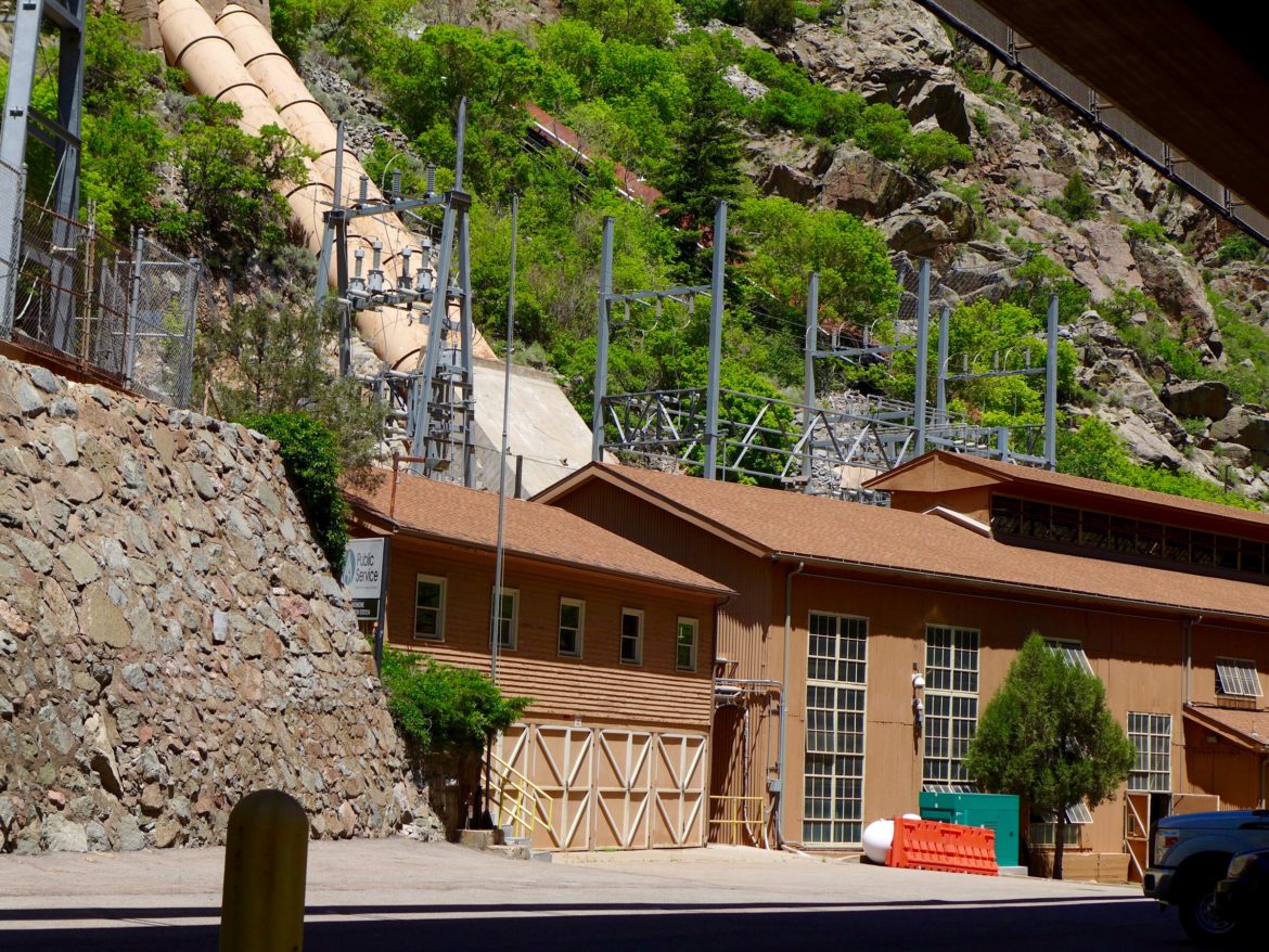
The Shoshone hydro plant in Glenwood Canyon, captured here in June 2018, uses water diverted from the Colorado River to make power, and it controls a key water right on the Western Slope. Source: Brent Gardner-Smith/Aspen Journalism
ByLindsay Fendt
It has been a rough year for operations at the Shoshone hydropower plant in Glenwood Canyon.
First, ice jammed the plant’s spillway in February, damaging equipment that required repair. The plant came back online in July but was able to generate electricity for only a few weeks before the Grizzly Peak Fire burned down its transmission lines.
According to the plant’s owner, Xcel Energy, the electricity impacts of the outages at the 15-megawatt generating station have been minimal, and the utility expects the plant to go back online this week. But while the electric grid can manage without the plant, the outage presents a much bigger threat to the flows on the Colorado River because the plant has senior water rights dating to 1902.
This means that any water users upstream with junior rights — which includes utilities such as Denver Water that divert water to the Front Range — have to leave enough water in the river to meet the plant’s water right of 1,250 cubic feet per second when the plant is running. When the Shoshone makes a call, the water makes its way through the plant’s turbines and goes downstream, filling what would otherwise often be a nearly dry section of river down toward Grand Junction.
A Shoshone call keeps the river flowing past the point where it would otherwise be diverted, supporting downstream water uses that would otherwise be impossible on this stretch of river. But when the plant is down, as it has been for most of 2020, that call is not guaranteed.
“Historically, what the Shoshone plant has done is kept a steady baseflow, which makes it easier for irrigators down here to be able to divert their own water right,” said Kirsten Kurath, a lawyer for the Grand Valley Water Users Association, which represents agricultural water users. “When the river goes up and down, it takes a lot of operational effort.”
The Shoshone water right also supports important nonconsumptive water uses. It provides critical flows needed for fish habitat and supports a robust whitewater-rafting industry in Glenwood Canyon. When the river drops too much below 1,250 cfs, it can create for a slow and bumpy ride.
“Customers get off and think, ‘Ugh, it would have been more fun to go to Disneyland,’ ” said David Costlow, the executive director of the Colorado River Outfitters Association. “Much lower and you are really scraping down that river and at some point you just pull the plug.”
The nearly year-long outages at Shoshone have many on the river worried. When the plant is down for repairs or maintenance, it does not make its call on the river allowing users upstream — including those that pipe water to the Front Range — to begin diverting. The Shoshone call can be the difference between the water remaining on the Western Slope or being diverted to the Front Range. Long outages, such as this one, reveal the vulnerability of the water on which so many rely.
“It’s a critically important component to the way that the Colorado main stem water regime has developed over more than a century now,” said Peter Fleming, the general counsel for the Colorado River Water Conservation District. “It’s sort of the linchpin or the bottom card.”
Water interests on the Western Slope have made some headway in recent years to maintain the status quo on the river even when Shoshone is down. Most of the major junior water-rights holders upstream of the plant — including Denver Water, Aurora and the Colorado Big Thompson Project — have signed on to the Shoshone Outage Protocol (SHOP). When the protocol goes into effect, as it has this year, these diverters have agreed to manage their diversions as if the Shoshone Plant — and the call — was online.
The agreement has been in operation for about a decade, helping to maintain flows during periods where the plant has undergone repairs or maintenance. The agreement was formalized in 2016 with a 40-year term. While the outage protocol has staved off major drops in the Colorado River flow over the years, the agreement is not as secure as water users that rely on Shoshone’s flows would prefer.
“SHOP is the best alternative that we have right now, but it doesn’t completely restore the flows,” said Kurath. “And one of the other problems right now is that it’s not permanent.”
For water users downstream of Shoshone, SHOP has three major issues. First, it is only guaranteed for 40 years, which for water planners is considered a short time frame. Second, the agreement does not include every upstream diverter, meaning that it doesn’t completely restore the flows to the levels where they would be if the Shoshone plant were on. Third, the agreement allows some of its signatories to ignore SHOP under certain water-shortage scenarios.
Despite the drought this year, the conditions never reached a point where SHOP’s signatories were able to opt out of the protocol, so the agreement went into effect when river levels dropped. But even though SHOP worked this year, the long outages at the Shoshone plant highlight the uncertainty of the plant’s future.
“We’ve always been nervous about it,” Fleming said. “It’s an aging facility, it doesn’t produce a ton of power, and we don’t know how long it’s going to be a priority to maintain and operate.”
The River District has been working to negotiate a more permanent solution for the Shoshone water rights for years. They have considered everything — from trying to buy the Shoshone plant outright to negotiating with diverters on the river to make something such as SHOP permanent.
The Shoshone outages have given these efforts renewed importance. In a recent board meeting of the River District, Fleming said that resuming talks with Denver Water that had stalled during the pandemic is a top priority.
While Fleming would not elaborate on the specifics of the ongoing negotiations, all options have the potential to impact many water users on the river — even those who aren’t at the negotiating table.
“We don’t approach this like we have water rights that we don’t have,” Costlow said. “But our business depends on water, and it depends on water levels that make water fun.”
This story ran in the Nov. 13 edition of The Aspen Times and was originally published on Aspen Journalism on November 13, 2020.
This story was supported by The Water Desk using funding from the Walton Family Foundation.
Here at the confluence of the Big Thompson and South Platte rivers near Greeley, a new conservation effort is underway. It restores wetlands and creates mitigation credits that developers can buy to meet their obligations under the federal Clean Water Act to offset any damage to rivers and wetlands they have caused. Credit: Westervelt Ecological Services
Developers often dropped by unannounced at the Allely farm to ask if the family would consider selling their 70-acre property south of Greeley at the confluence of the Big Thompson and South Platte rivers. The answer was always no — the Allelys did not want their land, which had been in the family since in the early 1960s, to be developed, now or in the future.
So when staff from Westervelt Ecological Services first approached the Allelys about creating a habitat preservation program on their farm roughly three years ago, the family was skeptical. But over the course of many months and long conversations, they began to warm to the idea and eventually agreed.
Instead of selling their property to the highest bidder or leaving it to the next generation, the family established a conservation easement — a permanent agreement to never develop the land — and, for a fee, allowed Westervelt to create the new Big Thompson confluence mitigation bank. The project broke ground in late October.
Now, a developer who disrupts wetlands or streams elsewhere along the Front Range and in parts of eastern Colorado can offset that impact by buying credits generated from floodplain and ecosystem restoration work completed on the Allelys’ land. Purchasing credits from this new mitigation bank allows developers to meet their obligations under the federal Clean Water Act.
“It’s a very important piece of property to us as a family,” said Zach Allely, the fifth-oldest of the six children who grew up on the farm. “If there’s an opportunity for us to say, ‘No, this is a place where native fauna, native flora can thrive forever,’ we’ll take that.”
Mitigation banks, explained
Mitigation banks are not new in Colorado — there are some 21 pending, approved, sold-out or suspended throughout the state, according to the U.S. Army Corps of Engineers’ database — but this is the first new mitigation bank approved on the Front Range in 20 years.
Across the country, mitigation banks have become more popular since 2008, when the U.S. Environmental Protection Agency and the U.S. Army Corps of Engineers expressed a preference for mitigation banks (over other types of mitigation) and offered clearer guidance, standards and timelines for these projects.
Mitigation banks like this one are a byproduct of the federal Clean Water Act, first enacted in 1948 as the Federal Water Pollution Control Act and then expanded and reorganized in 1972. More specifically, they relate to Section 404 of the act, which aims to protect the country’s wetlands from the discharge of dredged or fill materials during the construction of dams, levees, highways, airports and other development projects.
Under Section 404, developers must take steps to avoid and minimize damage to wetlands and streams by adjusting the scope, location, design and type of project they wish to undertake. After avoidance and minimization, they must turn to a third mitigation type: compensatory mitigation.
Under compensatory mitigation, developers can restore, establish, enhance or preserve wetlands at the project site or somewhere else nearby. But this type of work isn’t always practical or possible, which is where mitigation banks come into play. Instead of going to all that trouble, a developer can pay for someone else to do the heavy lifting at a different, nearby location.
A mitigation banker, in this case Westervelt, pays for the upfront costs of finding a suitable piece of land, gaining approval from the right regulatory agencies, and doing the actual mitigation work. Then, depending on the scope and size of the project, the banker can sell a certain number of credits to offset the impacts of future development within the bank’s general vicinity.
Restoring historical floodplain
Today, crews are hard at work on the Allely property, re-establishing the historical floodplain to help restore the ecosystem for plants and animals and improve flood resiliency for nearby communities.
This restoration work also creates 34.76 wetland credits and 460 stream credits — released in phases — that developers, public agencies, mining companies and others can buy to help mitigate the unavoidable damage their projects will cause to other Colorado wetlands and streams.
Lucy Harrington, the Rocky Mountain region director for Westervelt Ecological Services, declined to say how much the company is charging for credits from the new 72.4-acre bank, citing variable pricing and bulk discounts.
But the Colorado Department of Transportation, which regularly buys credits from mitigation banks across the state, recently paid $200,000 for a credit from the new bank to help offset the impact of its Central 70 highway improvement project, said Becky Pierce, CDOT’s wetlands program manager.
To find potential mitigation bank sites, Westervelt staffers perform geographic information system (GIS) analyses that take into account a property’s proximity to streams, hydrology, oil and gas infrastructure, and proximity to other conserved properties, among other factors, Harrington said.
The company, which opened its newest regional office in Centennial in 2016, also looks at community-identified areas for wetland restoration and conservation, as was the case with the new Big Thompson confluence bank. Westervelt staff worked with the Middle South Platte River Alliance to understand local priorities and identify possible sites for the new bank. The alliance helped introduce Westervelt to the Allely family.
“It’s really a confluence of technical work, relationship-building and a little bit of luck, to be perfectly honest,” Harrington said.
Westervelt and other mitigation bankers often buy property outright. But in this case, Westervelt paid the Allely family an undisclosed amount to use their land for the mitigation bank and, in return, the Allelys protected the property in perpetuity with a conservation easement, which comes with its own tax benefits and incentives. Westervelt and the Allelys also established a long-term endowment for the site’s management with the National Fish and Wildlife Foundation.
After creating a detailed plan and getting approval from regulatory agencies like the U.S. Army Corps of Engineers, U.S. Fish and Wildlife Service, Colorado Parks and Wildlife and others, Westervelt began work.
Credits going fast
The company has released its first round of credits, which includes 8.69 wetland acres and 115 functional feet of stream credits. So far, the company has sold more than half of the wetland credits, Harrington said.
“Any project, whether it’s a highway widening that may cross a river, home development that may affect ephemeral or perennial drainage, a Walmart parking lot that’s expanding, a pipeline going in, any of those development items that could impact wetlands and streams, instead of having to provide a wetland offset themselves can just come to us, write a check and just walk away,” Harrington said. “We take on all the liability of the site in perpetuity.”
Meanwhile, the Allely family knows that their property will never be developed and is instead being restored to its historical conditions. They can also still access the land under the conservation easement, which is held by the nonprofit land trust Colorado Open Lands.
Staff at Colorado Open Lands say they hope the success of the Big Thompson mitigation bank will inspire other landowners to conserve their land.
“It’s just another tool, another way for us to look at getting creative about protecting open space in Colorado,” said Carmen Farmer, conservation project manager with Colorado Open Lands. “Traditionally, we protect land throughout the state using state tax credits and federal tax deductions and incentives. Sometimes the traditional model doesn’t necessarily pencil out for landowners. This is another way for us to go about incentivizing landowners to help protect their properties and make sure they’re compensated for doing so.”
Sarah Kuta is a freelance writer based in Longmont, Colorado. She can be reached at sarahkuta@gmail.com
Fresh Water News is an independent, nonpartisan news initiative of Water Education Colorado. WEco is funded by multiple donors. Our editorial policy and donor list can be viewed at wateredco.org.
This story originally appeared on Fresh Water News on December 2, 2020.
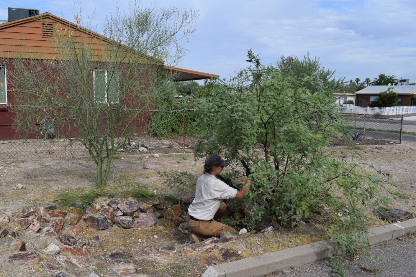
Madeline Ryder planting mesquite in an in-ground rainwater harvesting basin in the Sugar Hill neighborhood of Tucson, Arizona. Source: Watershed Management Group
By Chris Malloy
On Navajo Nation land, a mostly rural area removed from the extravagant artificial waterways that sustain Southwestern cities, roughly two-thirds of people have access to running water. Just beyond, on the Hopi Reservation in Black Mesa, Arizona, Diné (as the Navajo call themselves) sheep herders Arvin Bedonie and Marie Gladue lack both running water and a well. Without a car and too elderly to haul water, they have to dig deep into their pockets to obtain the water they and their curly-horned sheep need to survive. The herders overpay, spending about $40 a week.
“The water itself is probably $5 at most,” Gladue said. “But to have someone haul it for you, you’re paying for their time and labor. That’s what adds up.”
Last spring, Bedonie and Gladue turned to an ancient method to help address their water travails. They began to harvest rain.
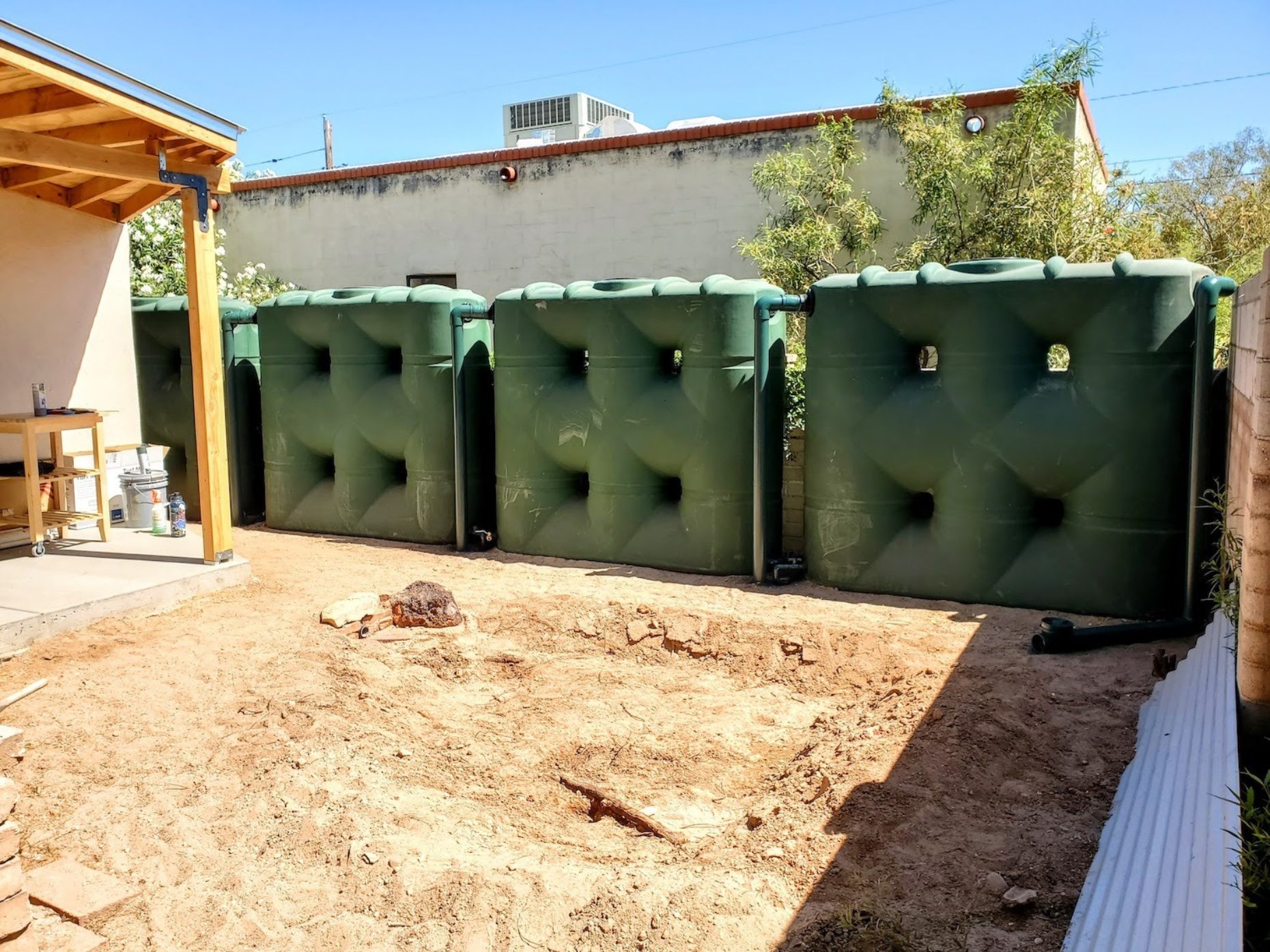
A line of 530-gallon rainwater tanks, square to better fit into a small space. Source: Lincoln Perino
Rainwater harvesting, or the collection of rain from building surfaces into vessels, might be the first way humans controlled water supply. The technology dates back at least to the dawn of agriculture. The ancients in Africa, Asia, Europe, and the Americas harvested rain. It provided water in rural Yemen, urban Rome, and Xochicalco in Mesoamerica, where rain from plazas and rooftops drained into subterranean cisterns, later used for domestic purposes or irrigation. Lacking a river, Jerusalem had cisterns that collected rain, including some carved into solid rock beneath the city.
Today, rainwater capture is used across the world. In Gansu, China, more than 10 million people have a water supply buttressed by rainwater, letting some make extra money through gardening, livestock, and poultry. In Sub-Saharan Africa, some crop yields have increased due to rainwater harvesting, according to one study. It is popular in India; in Gujarat, over a thousand schools are outfitted with rainwater catchment systems; in Tamil Nadu, all buildings must have them. More than a million homes in Australia capture rainwater. Residents of Bermuda and other islands lacking freshwater need the technology. People harvest rain in Egypt, Brazil, and Bangladesh.
Globally, rainwater harvesting can improve water access and help meet growing needs. Some 1.2 billion people lack access to safe drinking water. By 2050, the amount of food needed to feed the world is expected to double. Growing the crops to do so will take water. Though the earth looks blue from space, only three percent of our water is freshwater, and three-quarters of that is locked in glaciers (for now). That leaves about one percent of the planet’s water stock available for everyday uses like drinking, washing, and irrigation—a supply increasingly threatened as people across the globe continue to draw on aquifers and as climate change brings hotter, dryer conditions. In the American West, water has already become a pressing resource, as evidenced by the withering droughts of recent decades, and by the fact that, for instance, Arizona is already rationing its surface water supply. Rainwater harvesting—a cheap, low-barrier, low-energy method—may provide one piece of the long-term solution. It has a place in both urban and rural areas, and in developing and developed countries.
One percent of the planet’s water stock available for everyday uses like drinking, washing, and irrigation—a supply increasingly threatened as people across the globe continue to draw on aquifers and as climate change brings hotter, dryer conditions.
Most rainwater harvesting outfits look more or less like Bedonie and Gladue’s. They begin with a “catchment” surface like a roof. Rain splashes, rolls, collects, and sluices through a filter. A “roof wash” often ejects the first gallons, as these carry roof debris. Pipes or related conduits then deliver rain to storage tanks or simply the ground. From storage, water can be run to hoses, toilets, ponds, irrigation systems, herb gardens, peach trees, pet cage washing stations, even drinking glasses. With proper treatment, said Kathy Gee, professor in environmental science at Longwood University, “it’s very easy now to outfit rainwater harvesting in a way to produce potable water.”
In the United States, rainwater capture hasn’t been embraced beyond the community level due to a lack of government awareness and understanding. This is perplexing given its global reach and low-hanging benefits, like those Gladue and Bedonie enjoy (flexibility, drought hedge, access, decentralization) and others, like curbing urban flooding, stabilizing waterways during big storms, and conservation.
The potential for conservation is heartening. Rainwater harvesting could be a water source to ease mounting pressure on surface water and groundwater, by far the two biggest sources of water in the United States. This is vital given that waterways giving life to our farms and cities are stressed, like the Colorado River, and that our ancient aquifers, like the Ogallala, are diminishing. “Small changes make a big impact,” said Harold Thomas, assistant director of the Watershed Management Group in Tucson, Arizona, a city that pumps Colorado River water through more than 300 miles of desert. “The more that people use rainwater and stormwater, the less water we’re using that comes from the Colorado River and groundwater.”
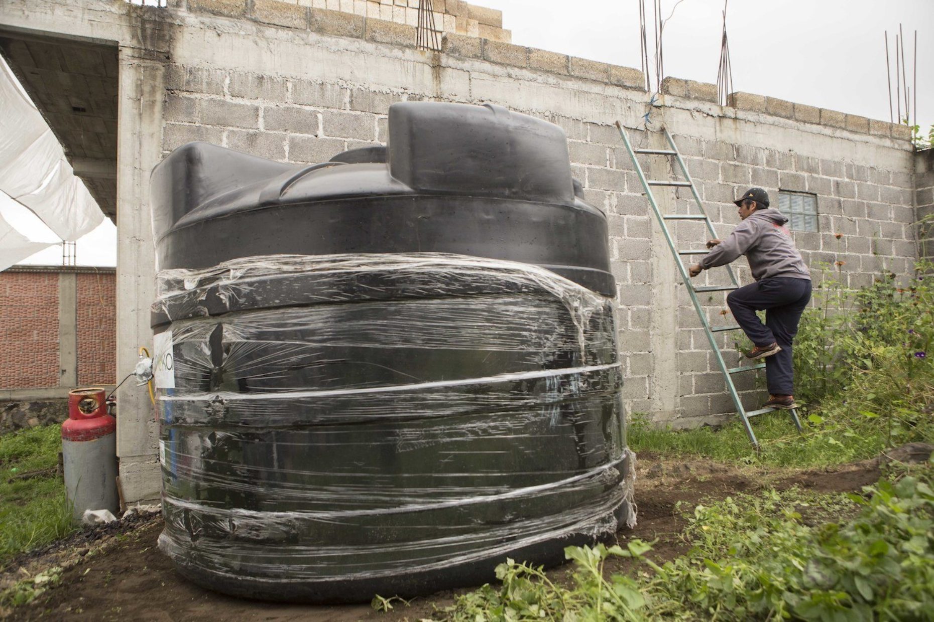
In this Sept. 3, 2016 photo, Edgar Serralde, a lettuce farmer in Mexico City’s borough Xochimilco, uses a ladder to climb on to his rooftop the day a large water cistern, left, was delivered to his home. Source: AP Photo/Christian Palma
Noteworthy conservation, however, would require widespread adoption—a pipe dream in the minds of rainwater installers, educators, and enthusiasts. You could live a life in the United States without noticing rainwater capture. Even desalination and wastewater treatment are more widely known. In ignoring rainwater harvesting, the U.S. is an outlier, an improvident anomaly across borders and time.
Rainwater capture isn’t scarce in the U.S. due to legality. Today, it is legal in every state, though many have restrictions. A few, like Colorado, were late to permit the practice due to the West’s old “first in time, first in right” water rights law origins. Colorado didn’t legalize it until 2016. Even now the state’s rainwater capture laws remain draconian, limiting harvesting to 110 gallons for non-potable purposes. To sufficiently capture bigger storms, Fouad Jaber, a professor and extension specialist in integrated water resources management at Texas A&M, recommends that quarter-acre homes have systems of “at least 1,000 gallons, if not 1,500.” Some other states, like Texas and Rhode Island, encourage the practice via tax incentives. Some local governments offer their own. Tucson has two tiers of rebate, including one for up to $2,000 based on tank size.
Despite legality and safety (with the right roof materials, pipe sealing, and treatment), many factors prevent U.S. adoption. One is money. Catchment systems are cheap relative to, say, drilling 200-foot wells, but they still have costs. And these might thwart urbanites who pay less for a month of city water than for dinner out for two. “Rainwater harvesting does pay for itself,” said William Hunt, an engineer, economist, and stormwater expert at North Carolina State University. “But in our experience, you would have to own that property for decades.” More so than solar panels, how long a system takes to become profitable varies (based on roof size, annual rainfall, and collection capacity). Some studies have even found that rainwater harvesting isn’t financially feasible, period. For millions off the water grid, though, harvesting rain is priceless.
“The more that people use rainwater and stormwater, the less water we’re using that comes from the Colorado River and groundwater.”
Another obstacle to widespread adoption is that many of its benefits are nebulous and rooted in future gains. Conservation remains a long-run abstraction for some people, especially people with pressing needs today, like those in the American West piped into hard-won water systems in place for generations. “If you look at the whole history of water in the West, it has really moved away from water as a fundamental resource,” said Brook Sarson, co-owner and CEO of Catching H2O, which installs rainwater harvesting systems in Southern California. “It has become a commodity, and that undermines the bigger picture of ecology.”
This 1,000-gallon tank in Tucson’s Palo Verde neighborhood collects rain from the roof. Source: Watershed Management Group
The reasons for non-adoption in the U.S. are many: a “yuck factor” (undue disgust at the idea of an atypical water source), newness (despite its long history), the cheapness of city water, a lack of education about the technology and water conservation, the litany of immediate problems that besiege the average person, and so on.
Moreover, local governments may have a disincentive to spur rainwater capture, which lacks a robust policy framework. “One of the biggest challenges of rainwater harvesting is that the regulations and permitting haven’t caught up yet,” Gee said. “We have found that it can be difficult getting a system approved.” Governments profit from selling water. When people harvest rain and trim or terminate monthly water bills, they profit less. “Water is important income for municipalities, so they could be resistant to things that take away their income,” Gee said. Sarson has navigated red tape when she installs systems and believes rainwater harvesting “is at odds with what the policymakers envision.”
As climate change brings deeper droughts, and as storms strengthen and rainfall variability grows more erratic, the value of rainwater capture in the U.S. might crisp into focus.
The practice is effective. Viewing rainwater capture as a way for communities and farms to counter climate change, UNESCOhas made it a pillar of its African Water Vision for 2025. In parts of rural Thailand, rainwater capture, sometimes using pots and jars, has improved access for people where centralized water systems are unreliable, according to one study. Another study found that rainwater harvesting may“fulfill the entire annual domestic water demand of a family in the rural areas of Bangladesh.” Still another reported that,globally, rainwater capture could provide up to 90 percent of urban household water consumption.
“If the rain used to come in one inch 30 times a year and now it’s coming in three inches 10 times a year, you’re going to have longer periods of droughts. Rainwater harvesting is going to allow you to have water during periods that are hotter and dryer due to climate change.”
In addition to carving out an alternate water source, rainwater harvesting might help bridge the dry gaps between the stronger storms of the future. “If the rain used to come in one inch 30 times a year and now it’s coming in three inches 10 times a year, you’re going to have longer periods of droughts,” said Jaber. “Rainwater harvesting is going to allow you to have water during periods that are hotter and dryer due to climate change.”
Since Gladue had her rainwater harvesting system installed in the spring of 2019, summers have been atypically dry, even for the Southwest. Still, when the scant rain of Black Mesa falls, water rills down the tilted roof of the sheep corral and a sloped gutter into two 660-gallon tanks, capturing, with 324 square feet of roof, about 200 gallons per inch of rain. From here, gravity feeds water through a black hose to a trough, where her woolly, curly-horned sheep can slurp away.
“Overall, I would say the system has been good,” she said. “If you can catch the water, it’s good. The sheep like it more than the other water, definitely.”
Gladue, a former employee of Black Mesa’s water department, wants to help spread the technology to friends and neighbors. “I’m hoping to write grants for other people to get barrels,” she said.
As the climate changes, local, state, or federal policy shifts might foster rainwater harvesting at scale, helping to make water more accessible and sustainable. Its current American standing trails the benefits of the practice, which, together with methods like stormwater capture and reusing air conditioner condensate, might net vital changes. “Rainwater harvesting is a key component,” said Hunt. “Can rainwater harvesting do it alone? In theory, it could, but I don’t see that happening. It will have to be part of a larger set of systems.” Until those systems form, we’ll watch rain fall unharvested, letting the world’s most precious resource slip away.
Chris Malloy is a writer from Philadelphia now based in the Southwest. For stories, he has gone foraging in the southern Rockies and Sonoran Desert, trailed a quest to brew ale overnight in a forest, roamed a feral mountain orchard with cider-making scientists, and gone hunting with Apaches. He is the food critic at Phoenix New Times.
Shortly after the networks called the 2020 presidential race for Joe Biden, a list of four priorities appeared on the president-elect’s transition website.
Until that point, the Biden campaign’s Build Back Better platform was anchored by a placeholder message, one that urged patience from the American people and noted that votes were still being counted.
On November 8, a day after the victory announcement, the four priorities appeared, simple and direct, a distillation of the Biden team’s main concerns as it prepares to take the reins of American government.
Covid-19
Economic Recovery
Racial Equity
Climate Change
Certain observers noticed a common thread — an undercurrent, if you will — that knitted these priorities together: water. Water, which washes hands during the pandemic. Water, which is needed for factories to produce goods, farms to grow crops, and cities to reboot. Water, which has sometimes been denied to communities of color or delivered in polluted form. And water, which is how a warming planet will wreak much of its havoc.
“Water is integral to all of those things,” said Heather Cooley, director of research for the Pacific Institute, a California-based environmental and public policy organization.
Cooley is not the only one to make that observation. Academics and former policy leaders chimed in. So did conservation groups like American Rivers, and think tanks like the Brookings Institution. Even the political consultant David Axelrod, at a Colorado State University symposium in mid-November, discussed how the incoming administration or another campaign could frame a water message. “It seems to me that part of the story you want to tell is the story of interconnectivity,” Axelrod said.
Out of this chorus a narrative has emerged: in a country that is politically fractured, water can unite.
“Here’s an opportunity with both Republicans and Democrats to be working on water together,” Cooley said. “It’s also an opportunity to be uniting us.”
But will it?
Popular opinions
An analysis of 2020 voting data by The Economist found a widening gap between urban and rural voters in the United States. The most urbanized counties gave a larger share of their vote to Joe Biden than they did to Hillary Clinton in 2016. Donald Trump, meanwhile, increased his vote share in the least urbanized counties. Red getting redder; blue turning bluer.
Those party and geographical divisions may seem rigid, but they are not insurmountable. Partisanship tends to peel away when it comes to water. In Colorado’s Delta County, for instance, Trump won more than two-thirds of the votes in November. But a regional measure to increase property taxes to pay for water projects, water conservation, and ecosystem protection gained 70 percent approval in the conservative county.
These results shouldn’t be surprising. Unlike climate change, which does score high marks for political division, water is generally an issue on which Republicans and Democrats agree, at least in the abstract. Water pollution doesn’t lend itself to an easy red-blue split.
Strange-bedfellow coalitions — of ranchers, Indigenous groups, hunters, and conservation organizations, which have come together in recent years to oppose the Pebble mine in Alaska and a groundwater pipeline from rural Nevada to Las Vegas — are not uncommon.
Because water bridges party politics, it could also unite urban and rural interests that otherwise seem at odds, Teodoro told Circle of Blue.
“Rural water problems — whether it’s affordability or access or quality — those problems are just as severe and often more severe than what we see in urban areas, and that creates an opportunity, an avenue for a political coalition,” Teodoro argued.
The seeds of that alignment are already in the ground. When people have a choice, they usually signal that they are pro-water, not only in opinion polls but in elections. Sri Vedachalam, who leads the water program at the Environmental Policy Innovation Center, has tracked state-level ballot initiatives related to water. His data set — which he notes is not exhaustive and focuses mainly on water infrastructure funding measures — goes back two decades. In that time, nearly 90 percent of water-related ballot initiatives were approved.
There are several explanations for the successes, Vedachalam said. People in the U.S. are more fiscally liberal than stereotypes would suggest and they are willing to pay for important projects with local benefits, especially water systems. Water is generally a non-partisan issue, unless leaders politicize it. And such measures often must clear procedural thresholds, such as approval by the Legislature, before they reach the ballot. This means widespread political support going into the election.
Still, water scores highly because the result is tangible, Vedachalam told Circle of Blue. “People see the project at the local end.”
Recent election cycles reflect that connection to place leads to a willingness to spend. Besides the Colorado tax measure, voters in Los Angeles and Santa Clara counties passed or extended water infrastructure taxes. Voters in Texas passed two bond measures to fund drinking water improvements in low-income areas and flood protection.
Not to be outdone, voters in Orange County, Florida, overwhelmingly approved an amendment that changes the county charter to give legal protection to rivers. The amendment, which drew in voters of all political stripes, passed with an unusually high margin: more than 89 percent of the vote.
Water — and indirectly, climate
Early actions during the presidential transition suggest that climate has vaulted to the forefront of the Biden administration. Former secretary of state John Kerry was named the administration’s climate envoy, not only representing the government in international discussions but also earning a seat on the National Security Council.
But given the political dynamics of climate, some observers feel that smarter policy might require that the issue be reframed around water.
“Let’s not talk about climate,” Teodoro said. “Let’s do climate policy, and talk about water. And that’s not being sneaky. That’s just being effective.”
For Felicia Marcus, climate progress has been frustratingly slow. But the former head of the California Water Resources Control Board says that water is an entry point for responding to a warming planet, a way to engage communities on the inevitable damage to their homes and their towns unless they act.
“Adaptation work isn’t as controversial because water is the bleeding edge — it’s where we’re going to feel the impacts of climate change,” said Marcus, currently a fellow at Stanford’s Water in the West program. Adaptation, she argued, can set the stage for work on reducing emissions.
“You can relate to the impacts,” she said.
In the art of the possible, what could be painted?
Uniting over water is no guaranteed bet, Teodoro said. Democratic leadership seems willing to act — and willing to substantially increase federal funding for infrastructure — but that must be coupled with a good-faith effort from Senate Republicans, who could maintain their majority and block legislation. President Biden could govern by executive order, but those directives can just as easily be undone by the next administration.
Still, there are examples to build from in both chambers. Rep. Brian Fitzpatrick, a Republican who represents suburban Philadelphia, and Rep. Antonio Delgado, a Democrat from upstate New York, co-sponsored three bills in response to contamination of waterways with toxic PFAS compounds. Fitzpatrick was one of 37 representatives to ask the EPA and Department of Education to provide schools and day cares with the necessary resources to identify PFAS contamination within their buildings.
Rep. John Katko, a New York Republican, introduced legislation in March that would establish a federal water research program for testing and deploying the next generation of treatment, monitoring, and recycling technologies. In effect, it would build on the legacy of the ARPA programs that leveraged federal funding to spur technological innovation in defense, computing, and energy systems. The bill did not get a hearing in committee.
Marcus feels that technological innovation is a winning strategy, especially alongside the push for more federal investment in water infrastructure. The next generation of water technology could be smarter, more efficient, and designed for a climate in flux.
“We can rebuild more deftly,” Marcus said. “We don’t want to rebuild the infrastructure of the 1970s.”
Biden’s choice of running mate has encouraged advocates who feel that Kamala Harris will be a voice for environmental justice and give attention to water. In her time in the Senate, Harris introduced several bills on these subjects, including the Water Justice Act, which would have expanded funding for water infrastructure and focused on rural areas and low-income communities. (It did not move out of committee.) Early in the pandemic, Harris urged utilities not to shut off service because of late payment.
There are other water actions that link to the Biden administration’s four priorities. Anne Castle, a former Obama administration official in the Department of the Interior, said that the Biden administration could focus on universal access to drinking water on Indian reservations.
These sorts of commentaries — that water is a tangible, local concern on which real progress can be achieved — are a cottage industry in the wake of the Biden-Harris victory and other electoral triumphs.
The president of the conservation group Western Resources Advocates and the executive vice president of the Colorado Cattlemen’s Association co-authored an opinion piece praising the residents of that state, who approved three local or state tax increases in the last two years to fund water projects.
“Water will always have its conflicts, but the last two years have taught us that when future water funding needs and opportunities arise, a diverse cross-section of Colorado stakeholders and voters will support them every time,” Jon Goldin-Dubois and Terry Fankhauser wrote.
Farther west, Ann Hayden of the Environmental Defense Fund shared a byline with Cannon Michael, the chief executive of Bowles Farming, which is located in California’s Central Valley, a region perpetually riven with water disputes. They argued that water is “a lifeline that binds us together,” and that the shared heritage could separate it from the typical political fray. As long as the interest groups are willing.
“We have decades of experience coming at water challenges from our silos,” they wrote. “Let’s break down those silos, come together as Californians and see what happens. Isn’t it worth a shot?”
Marcus, for one, is all-in with this type of thinking. And she thinks many others are, too.
“Beneath the partisan bickering, which is aided by lawyers and lobbyists that thrive on discord, there are people who want to fix stuff,” Marcus said. “I think there’s a hunger for problem solving.”
“Water is the place to do it,” she continued. “It could change millions of lives for the better and set the country on course for the 21st century.”
Brett Walton writes about agriculture, energy, infrastructure, and the politics and economics of water in the United States. He also writes the Federal Water Tap, Circle of Blue’s weekly digest of U.S. government water news.
Cattle have their evening meal in the San Luis Valley. Investors here and elsewhere in Colorado have purchased farm land and water rights with the stated intent of exporting it to the Front Range, a plan that worries some lawmakers. June 6, 2019. Credit: Jerd Smith
By Sarah Kuta
Colorado’s anti-speculation water laws are considered some of the toughest in the West. Still, state lawmakers worry those laws may not go far enough to prevent water profiteering.
Now, an 18-member work group charged with exploring ways to strengthen the rules is getting down to business.
The work group stems from the passage of Senate Bill 20-048, a bi-partisan effort signed into law by Gov. Jared Polis in March that directed Colorado’s natural resources department to convene the group to study anti-speculation law. The group’s recommendations for any proposed changes are due in August 2021.
“In my mind, I think speculation is going on,” said Colorado State Sen. Don Coram, a Republican who represents several Western Colorado counties and co-sponsored the legislation to form the work group. “There are situations that are just not meeting the smell test for me. We need to look under the tent and see what’s going on.”
The group is led by Kevin Rein, state engineer, as well as Scott Steinbrecher, a Colorado assistant deputy attorney general. Other members include water engineers, members of the Colorado Water Conservation Board, a retired Colorado supreme court justice, farmers and ranchers, local and regional water managers, and several attorneys.
Water law has a long history here, with roots dating back to the 1860s, when Colorado was still a territory. Today, Colorado’s water law prohibits speculation and requires that all water be put to beneficial use, an umbrella that encompasses uses like irrigation, commercial, domestic, industrial, municipal, environmental, recreation, fire protection, snowmaking and power generation, among others.
The water laws are built on a legal framework known as prior appropriation, which means that those with the earliest court-decreed water rights — known as senior rights — get first dibs on Colorado water, a concept that’s often referred to as “first in time, first in right.”
Water rights can be leased, sold, transferred and changed; new water rights can even be decreed, so long as there’s water available. All water rights cases must go through a complex water court process that includes demonstrating how the water will be put to beneficial use.
These requirements are intended to safeguard against speculation. But with water demand and prices soaring, lawmakers worry about loopholes in the process, pointing to recent investment group purchases of farm land and their senior water rights on the West Slope and in the San Luis Valley. So far, the investors are continuing to use the water for irrigation, a beneficial use, but lawmakers worry they will turn around and sell the rights for a profit in the future. Irrigation may just be an interim placeholder that’s part of a larger investment strategy.
So, how will the work group’s members untangle 160 years of complex water rules and make recommendations for ways they could be improved? They’ll likely start with a thorough history lesson and a deep dive into existing anti-speculation law, said Rein, the group’s co-chair, adding that he believes the group is well-poised to tackle the challenge at hand.
“You see a very diverse group of knowledge — attorneys, municipal water providers, agricultural users,” Rein said.
Joe Bernal, a fourth-generation farmer in the Grand Valley and a member of the new work group, said he’s glad to be part of a conversation that impacts his family’s livelihood.
“I’m minding my own business, so to speak, so that things won’t be decided for us by outside groups who don’t have a vested interest in what we’re doing,” he said. “You have to have skin in the game and a good understanding of issues if you’re going to try to influence decision-making.”
Another group member is Joe Frank, general manager of the Lower South Platte Water Conservancy District in northeastern Colorado. He plans to participate with an open-mind, but already he’s contemplating how proposed changes to Colorado water law could hurt landowners: How will the changes impact an irrigator’s ability to sell their water and land? Will the value of their land or water suffer because of these changes?
“There’s this tension here, especially in our basin, but also statewide, of a high demand for water, which inflates the value of it — it’s hard to blame farmers for wanting to sell their water because of all different kinds of circumstances,” he said. “We would prefer them to keep their water and stay in agriculture because that’s the economic base for our area. But you can’t just go say, ‘We’re going to put a stop to it.’ Now you’re impacting somebody’s property rights.”
Frank said he also has some questions about the constitutionality of any changes the group may propose.
“I do have some reservations about whether this will actually solve a problem without causing another one,” he said. “You don’t want to cause unintended consequences here.”
This article first appeared in the Fall 2020 issue of Headwaters magazine.
Sarah Kuta is a freelance writer based in Longmont, Colorado. She can be reached at sarahkuta@gmail.com.
Fresh Water News is an independent, non-partisan news initiative of Water Education Colorado. WEco is funded by multiple donors. Its editorial policy and donor list can be viewed at wateredco.org.
COYOTE SPRING VALLEY, NEV. — Five wells punch the scorching Nevada desert.
Water in this area is locked underneath the ground. It flows silently and invisibly as part of an aquifer stretching roughly 50,000 square-miles. Much of this water collected here thousands of years ago when lakes covered most of Nevada. Now wells are summoning it for human use. The problem is there’s not enough to go around.
At the center of this tension are the five wells.
A housing developer, Coyote Springs Investment, owns four wells, planted to one day pump water for a sprawling new community in the desert, filling the highway stretch about 50 miles northeast of Las Vegas. The remaining well belongs to the Southern Nevada Water Authority.
Coyote Springs wants to pump its wells. The water authority wants to keep most of it in the ground.
The five wells mark divergent interests with a history intertwined by a similar goal: development and the need to secure the water to make it happen. But today the housing developer and the powerful water utility, locked into past contracts, are caught in a fight, playing out in hydrologic reports and hearing rooms, over what might seem a simple question: How much water is there?
Daniel Rothberg/The Nevada Independent
Longform Story CSS Block
That answer is complicated by how much is at stake — a Colorado River tributary, the survival of an endangered Nevada fish and the future of development in a sweeping area outside Las Vegas.
In the early 2000s, during a period of rapid growth, Southern Nevada politicians gave Coyote Springs their blessing to develop a new community, spanning two counties (Clark and Lincoln) on empty land about 50 miles outside of Las Vegas. Thousands of homes. Golfing. Shopping. Gambling. They would call the community Coyote Springs, named for the valley it occupied.
On a recent hot August morning, what was once planned as a Palm Springs in Nevada is still mostly empty. Two temporary street signs, for CS Parkway and F Street, mark an intersection that has yet to be paved. At least $200 million in infrastructure — flood control, fiber optics, a detention basin and wastewater treatment plants — lies around both sides of the highway. Most of it goes unused, with one exception: A well-manicured golf course meant to attract homebuyers.
But there are no homes. State officials won’t allow it, and it has everything to do with the wells.
In the early 2000s, during a period of rapid growth, Southern Nevada politicians gave Coyote Springs their blessing to develop a new community, spanning two counties (Clark and Lincoln) on empty land about 50 miles outside of Las Vegas. Thousands of homes. Golfing. Shopping. Gambling. They would call the community Coyote Springs, named for the valley it occupied.
There was a time, not long ago, when all the political juice appeared to be flowing to Coyote Springs. Then it slowed to a trickle. Political momentum only gets you so far where water is scarce — and Las Vegas has its supply on the line. At least that’s how Coyote Springs sees it.
“Someone doesn’t want us to develop,” says Emilia Cargill, chief operating officer for Coyote Springs Investment. “How do you stop someone from developing? You take their water away.”
In the past two years, Coyote Springs has taken the issue to court. In 2018, it sued an arm of the water authority with claims including slander and breach of contract. It has sued the state twice. In August, Coyote Springs accused state officials of taking their property: the right to use their water.
The fight over Coyote Springs is about the collision of water, science and politics. And it reflects a broader tension facing Nevada and the modern West, a reckoning with a past in which water officials handed out legal rights to use an unsustainable amount of water: first come, first serve.
In Nevada and elsewhere, the problem is made more severe because the law developed to view rivers and groundwater as separate stores of water, despite generations of science and observations showing that the two often act as one. In places like Coyote Spring Valley, this paradigm led past officials to overestimate the amount of water rights available to hand out.
Nevada’s water statutes follow a similar framework used across the West. That framework is meant to settle disputes, inevitable in a region where aridity is its defining character. Yet state regulators often face serious barriers to enforcing the rulebook in a manner that is cut-and-dry.
The fight over Coyote Springs is about the collision of water, science and politics. And it reflects a broader tension facing Nevada and the modern West, a reckoning with a past in which water officials handed out legal rights to use an unsustainable amount of water: first come, first serve.
Today regulators recognize the issue, and they are trying to tackle the problem.
But the solutions are challenging and even collaborative deals to rein in overuse end up in court. Local judges weigh in, then many decisions are appealed to the Nevada Supreme Court, which often has the final say. Every watershed is different. Yet the future, in most cases, looks similar.
Someone is going to get less water than once promised.
The Muddy River Springs area from State Route 168 on Aug. 13, 2020. (Jeff Scheid/The Nevada Independent)
Warm springs, hot drought
Drive a dozen miles away from Coyote Springs and the landscape changes dramatically. State Route 168 sits on top of the expansive aquifer. At first, this stretch of highway looks like the rest of the desert. It’s hot. There’s not much water. Then you arrive at the Muddy River Springs area.
The creosote bushes and prickly desert vegetation give way to palm trees and honey mesquite as groundwater discharges into a series of springs, enough to create a small river in the desert.
The narrow Muddy River flows beside rural communities, a former coal plant and agricultural operations, before joining with the Colorado River and emptying into Lake Mead, which stores water for sprawling cities, farms and businesses in Arizona, California, Nevada and Mexico.
The water authority owns or leases the rights to most of the Muddy River. Officials store that water in Lake Mead, making this humble tributary a critical part of Las Vegas’ water portfolio.
“The water that we use on both the Muddy and Virgin River to [store] in Lake Mead is probably, next to our Colorado River allocation, the most important allocation of water that we have,” says Colby Pellegrino, who serves as the water authority’s deputy general manager for resources.
Because groundwater feeds the Muddy River, the river’s flows are modeled to decrease as more wells are turned on and an increasing amount of water is pumped out of the ground.
Different hydrologists offer different models for this behavior. But enough is known about the hydrology that state officials ruled in June that there was a significant degree of connection: When too much groundwater is pumped up, less water makes it to the springs and the river.
The dispute is over how much is too much.
And the fear is once Coyote Springs and other groundwater users crank up the spigot, it could one day leave Las Vegas with less water, despite having rights that were issued prior to 1920.
Groundwater pumping at Coyote Spring Valley is not the only threat. Other interests, including the Moapa Valley Band of Paiutes, the Moapa Valley Water District, the Mormon Church, NV Energy and the Southern Nevada Water Authority itself, have rights to capture groundwater.
Last year, the water authority argued that the area could only sustain a little more than half of what is currently used, almost one-tenth of the volume that businesses have the right to use.
Their estimate comes as the West faces a drier future. Scientists say a climate change signal is already evident in decreasing the flows of the Colorado River, the primary water source for the Las Vegas Valley. With warming temperatures, water managers in the seven states that use the Colorado River are all figuring out how to firm up existing supplies while doing more with less.
Las Vegas, with the Muddy River, is no exception.
U.S. Geological Survey instruments measure streamflow in the Warm Springs area. (Jeff Scheid/The Nevada Independent)
The endangered Moapa dace (U.S. Fish and Wildlife Service)
A diver counts the Moapa dace population. (U.S. Fish and Wildlife Service)
In the Muddy River Springs area, palm trees provide a respite from the summer heat. As Patrick Donnelly, the state director for the Center for Biological Diversity, comments on the unique smell of a riparian area in the desert, he has his eyes on another pressing concern.
Each year, divers put on snorkels, enter the protected springs and assess the health of the dace habitat. In August, divers reported a 78 percent increase from last year, a jump to 2,342 dace.
But Donnelly, the water authority and federal wildlife managers are still worried that additional groundwater pumping would reverse gains made through habitat restoration at the springs. And there is evidence to back up their claims.
Increased groundwater pumping during a stress test in the mid-2010s led to a decline in several high elevation springs, according to streamflow and pumping data. Drawing on that data, the U.S. Department of Interior concluded in 2013 that at least two springs could dry up within three years if higher levels of pumping were to continue.
“This is your ultimate example of surface and groundwater as the same resource.”
– Patrick Donnelly, Center for Biological Diversity
“The spring levels went down with the pumping,” Donnelly said. “And they haven’t recovered.”
“This is your ultimate example of surface and groundwater as the same resource,” he added.
Reversal of fortune
Golf carts sit in a neat row at the parking lot for Coyote Springs. Military jets from the Air Force’s Nevada Test and Training Range, tucked behind the mountains, can be heard circling nearby. The $40 million golf course, a splash of green in the desert, was built to attract homebuyers.
Behind the golf carts is a pro shop, and behind the pro shop is Cargill’s office. On one wall is a map of groundwater in the region (all flows point to Lake Mead). And taped to Cargill’s computer is a section from a ruling issued by Nevada’s top water regulator (why they can’t build homes).
“It’s all flowing down to Lake Mead,” Cargill says, nodding to the annotated map posted to a wall. “And who benefits from water going into Lake Mead? Southern Nevada Water Authority.”
Coyote Springs believes there are a few geologic caveats to that flow pattern.
In preparation for a hearing last year, Coyote Springs commissioned a geophysics consultant to study the geology within the aquifer. The analysis argues that geologic structures on the west side of the valley trap water. The finding, Coyote Springs asserts, means that they can pump groundwater without it directly affecting the springs. Simply put, there is water to build homes.
Many models show the aquifer, known as the Lower White River Flow System, behaving as a “bathtub:” If you remove one gallon of water in one area, you leave the whole aquifer with less. That is, if you pump water at Coyote Springs, you are likely to affect surface water miles away.
“Our argument is that that’s not true — that there are a lot of places where there are faults or slips or strikes underground,” Cargill said, noting the visible geologic formations in the valley.
Men ride a cart while golfing at Coyote Springs, located 55 miles northeast of Las Vegas, on Tuesday, July 10, 2018. Nevada’s top water regulator is blocking the development because there may not be enough ground water to support it. (Jeff Scheid/The Nevada Independent)
Still, enough is known about the aquifer that Nevada’s top water official, State Engineer Tim Wilson, ruled in June that the “best available data” did not support Coyote Springs assertion, even if geologic variations exist. Two days later, Wilson’s office again denied its plans to build.
In August, Coyote Springs sued the state, alleging that the state engineer’s office made a series of decisions that resulted in an “unconstitutional taking” of the water rights it needs to develop. The court filing said the state’s own science supported more groundwater pumping in the area.
Over the past year, it has accused local agencies, which once helped move the project forward, of doing the same. The fight is no longer only about hydrologic modeling. It is also about politics.
As the water purveyor for Coyote Springs, top officials at the water authority, in addition to the Clark County Commission, carry legal sway over whether homebuilding can move forward.
Past Clark County Commissions supported the project, approving a development agreement and entitlements throughout the past two decades. In 2018, the County Commission, then chaired by Gov. Steve Sisolak, approved a zoning change and tentative map for 575 single family lots. Former Sen. Richard Bryan represented Coyote Springs before the commission.
At the time, county attorney Robert Warhola said the approval was “not going to go anywhere unless they resolve the water issue.” State water officials would still have to sign off on the plan.
Today Clark County appears to be backing away. In January, county officials started a process to acquire Coyote Springs’ land, according to records requested by The Nevada Independent.
Coyote Springs overlaps with critical habitat for the Mojave desert tortoise. Because the Mojave desert tortoise is listed as threatened under the Endangered Species Act, the county is required to offset — or conserve — a certain amount of acreage in order to permit new development. As Las Vegas looks to expand along the I-15 to California, it needs to protect more tortoise habitat. In Coyote Springs, the county believed it had a willing seller.
An acquisition of Coyote Springs would also be a win for conservationists, too. Since the project was first proposed, groups, including the Sierra Club, have raised concerns that a faraway community would affect air quality, increase vehicle emissions and encourage sprawl.
According to a draft proposal, the acquisition was part of a phased approach to buy land from Coyote Springs and move development plans away from building a sprawling town 50 miles away, one that might conflict with the Air Force’s operations.
The acquisition would effectively unwind development plans that had originally been pushed by one of the state’s most powerful lobbyists, Harvey Whittemore, and supported by some of the state’s top politicians, including former Senate Majority Leader Harry Reid. Whittemore was imprisoned in 2014 for giving illegal campaign contributions to Reid, allegations stemming from a legal feud with his former business partners, Bay Area developers Thomas Seeno and Albert Seeno Jr.
Former Clark County Commissioner Chris Giunchigliani was the only vote against the zoning change and tentative map in 2018. Coyote Springs, she said, offers insight into how developers could push forward a project without the commission weighing the long-term impacts, especially in the boom years.
“It’s a perfect example of bad public policy being advanced just because we knew someone,” said Giunchigliani, who was elected to the commission in 2006 after serving in the Legislature.
In April, the proposed acquisition appeared on a draft agenda for the County Commission’s approval. The item proposed acquiring roughly 6,900 acres of Coyote Springs’ land, with the Air Force, for about $35 million. Then the item was abruptly taken off the agenda. Cargill sent a letter to Marci Henson, director of the Clark County Department of Environment and Sustainability denying the county’s offer.
Cargill wrote that there was “significant disagreement” over the proposed acquisition, including the valuation and a disregard for development rights issued by the county.
Coyote Springs, Cargill writes in the letter, was “gravely concerned” that entities, including the state engineer, the Las Vegas Valley Water District, the Southern Nevada Water Authority and Clark County, “have, and continue to, individually and collectively, take actions in bad faith” to stop the development, drive down the market price and effectively “take” away their property.
In an emailed reply, Henson said she was “surprised by the letter,” writing that the “tone and content bear no relationship to our previous discussions and communications. ”As part of the email chain requested by The Nevada Independent, Henson said Coyote Springs had not been “truthful” about being a willing seller. In response, Cargill wrote that the developers “take offense with Clark County’s assertion.” She then said the county had not been “forthright” either.
A view of Hoover Dam is seen from the Mike O’Callaghan/Pat Tillman Memorial Bridge on Wednesday, Aug. 28, 2018. (Jeff Scheid/The Nevada Independent)
Divergent interests
The proposed acquisition was not only about the land. It was also about the water.
According to a draft of the county’s proposed acquisition, the water authority expressed interest in buying Coyote Springs water rights to protect the Moapa dace. Such a move would eliminate increased groundwater pumping, a threat to surface water: the springs and the river.
Where the groundwater gives way to springs, Coyote Springs and the Southern Nevada Water Authority’s interests part ways. Coyote Springs is still focused on pumping more groundwater. Today the water authority is focused on maintaining the flows of the Muddy River, where it owns and leases rights to water — water that is stored in Lake Mead.
The water authority is also invested in the Moapa dace’s recovery. Reliant on steady spring flow, the two-inch fish is considered an indicator species for the watershed’s overall health.
“We as water managers know that if you have an endangered species issue, you have a water supply issue if that endangered species is using the same source of supply as you are,” Pellegrino said.
For years, Southern Nevada politicians, the water authority and Coyote Springs appeared to be working hand-in-hand on developing Las Vegas, the water wells and securing water to construct new homes in the fast-growing region. In the 1990s, the water authority even purchased millions of gallons in water rights from Coyote Springs to augment its relatively small Colorado River allocation.
“When Coyote Springs was a big issue — or expected to set the world on its ear — two things were going on,” said Michael Green, an associate history professor at UNLV who has studied the development of southern Nevada. “One was that the [housing] boom seemed constant.”
The other had to do with different attitudes about the limits on water.
“We know more about the trends in water availability than we did 25 years ago,” he said. “The thought that we have the water or we can get the water was in people’s minds.”
In the 1980s, Las Vegas officials placed their bets on groundwater in the Coyote Spring Valley. At the time, the land belonged to Aerojet, an aerospace company that wanted to test rockets.
“We were going to buy all of Aerojet,” said Pat Mulroy, who played a key role in the agreements and deals involving Coyote Springs as the water authority’s former general manager. “We were going to buy the whole thing, kit and caboodle.”
But everyone’s bets on groundwater in the valley were off; the sustainable supply was small.
As the groundwater showed its limits, the water authority turned to surface water on the Muddy River, acquiring water rights through purchases or leases.
For Coyote Springs, this created an inevitable conflict.
As their water purveyor, Las Vegas officials were charged with deciding whether Coyote Springs could pump its water. At the same time, they have a stake in seeing less pumping, not more, to protect the groundwater-fed flows of the Muddy River.
Since 2017, the water authority — along with state officials — have raised concerns about Coyote Springs’ efforts to use its water rights. Las Vegas water officials contend that the responsible choice, as a water provider, was to take action before Coyote Springs built homes, given the ongoing concerns about groundwater use.
But Cargill said that the water authority is “conflicted” between its multiple roles. She added that state and local agencies should have considered the water scarcity issues before entitling the project, a process that gave the developers the belief that they were allowed to build.
“We had entitlements,” Cargill said. “We had permissions to build. That’s why we bought the water. That’s why we bought the land. That’s why we spent the money. We wouldn’t have spent what we’ve spent and continue to spend on a daily basis if we hadn’t had assurances that we were going to be able to develop.”
Timeline of Recent Issues
April 2017: The Las Vegas Valley Water District expresses concern that “any substantial volume of water” running through Coyote Springs’ wells could impair spring flow for the Moapa dace and Muddy River rights, most of which the water authority owns or leases. Water authority officials brought their concerns to Nevada’s top water official, the state engineer.
May 2018: Albert Seeno III, a Bay Area and Reno developer behind Coyote Springs, became personally involved, talking to then-State Engineer Jason King. According to Coyote Springs lawyers, King told Seeno “not to spend one dollar more on the Coyote Springs Development Project and that processing of [its development] maps had stopped.”
September 2018: Per a court settlement, King conditionally approved subdivision maps if Coyote Springs could prove that the groundwater could be pumped sustainably.
September-October 2019: The state engineer held hearings on the hydrology of the area after water users in the region submitted exhaustive hydrologic reports and modeling.
June 2020: After a new order on the issue, declaring that the region had less available groundwater than once previously thought, the state again recommended denial of development maps.
Records show that the limits to groundwater supply were well-established. For this reason, Wilson, the state engineer, as well as other water authority officials, have dismissed claims that Coyote Springs was short-changed or not informed of the scarcity issues in the area.
“The water issues out there had been known for a very long time,” Wilson said.
Over the years, as Coyote Springs progressed through the local planning process, developers were warned repeatedly, Mulroy said. But they remained convinced the water was there. If Coyote Springs wants to develop today, “they’re going to have to bring water in from somewhere,” Mulroy added.
The Southern Nevada Water Authority’s MX-5 well and associated facilities in Coyote Spring Valley on Aug. 13, 2020. The well is named for when the federal government sought this land for its MX Missile Program. (Jeff Scheid/The Nevada Independent)
A long path forward
The fight over water at Coyote Spring Valley is long from over.
In June, the state engineer’s office issued an order capping regional groundwater pumping at 8,000 acre-feet (an agricultural term describing the amount of water that can fill one acre to a depth of one foot). It’s twice the cap that the water authority had hoped for, but it’s far less than the roughly 30,000 acre-feet that Coyote Springs had suggested was available.
The cap means that the vast majority of groundwater rights in the area — about 31,000 acre-feet — are going to have to be restrained. The question now is how to do that equitably.
A large amount of water in the Muddy River watershed is controlled by the Moapa Valley Water District, which provides service to the Moapa Valley Band of Paiutes and two rural communities.
Should water used to serve existing communities be prioritized?
The path toward a resolution to decide who can use their groundwater — when, where and how much — reflects a complicated future, not only for Coyote Springs but in areas across Nevada, where past state officials routinely issued more water on paper than there is water to go around.
Correcting this problem is challenging. Decisions to appropriate, and over-appropriate, water were made decades ago. State officials did not always incorporate the same values, especially around protecting the environment, that policymakers consider now. And to fix the issue, regulators are constrained by a system of agreements, entitlements and plans that were approved in the past.
The path toward a resolution to decide who can use their groundwater — when, where and how much — reflects a complicated future, not only for Coyote Springs but in areas across Nevada, where past state officials routinely issued more water on paper than there is water to go around.
The state engineer’s order recognizes the connection between groundwater and surface water, and it proposes an approach that aims to look at the whole puzzle, not just the puzzle pieces.
But nearly everyone involved in the area found something to disagree with. At least ten water users — companies and government agencies — are participating in a judicial review in Las Vegas district court.
“I don’t think the litigation’s ending any time soon,” Pellegrino said.
Pellegrino’s hope, though, is that litigation will yield to collaboration. As an example, she cited the Colorado River, where water users with competing interests and constituencies have opted to enter into collaborative agreements rather than gamble on the results of a lengthy fight in court.
“There is a path forward for the people who are using water [and] for the people who have water to come together, kind of like we do on the Colorado River, and say ‘Now that we know what the quantity of water is that we’re working with, how are we going to make this work,’” she said.
Emilia Cargill outside of the Coyote Springs Golf Club on Aug. 12, 2020. (Daniel Rothberg/The Nevada Independent)
Water infrastructure built at Coyote Springs to prepare for building homes. (Daniel Rothberg/The Nevada Independent)
A road sign advertising the Coyote Springs Golf Club. (Jeff Scheid/The Nevada Independent)
As the court battles continue, Coyote Springs remains focused on building homes.
“That’s what we do as a company,” Cargill said. “We’re not in the business of running golf courses. That’s not what we do. We’re not in the business of running a tortoise habitat. That’s not what we do. We build homes. We build communities. We build infrastructure. We build shopping centers. That’s what we do as a company. We run casinos. That’s what we do.”
And Coyote Springs has more rights to water. The groundwater is not its only source. About one hundred miles to the northeast, Coyote Springs owns ranches in Lake Valley near the small town of Pioche.
In December 2008, the state engineer approved a plan allowing Coyote Springs to export a portion of its ranch-water to the new desert community. Although the state’s order placed limits on the exportation proposal, it allowed for piping 11,300 acre-feet of water, enough water to supply tens of thousands of new homes.
But “that water wasn’t intended to be the first water used,” Cargill said.
“That water was intended to be the next water used,” she added.
Any such effort to import the Lake Valley water would be years away, requiring new permits and adding significant costs.
Yet even in Lake Valley, more than a hundred miles away from Las Vegas, the future is complicated by the past. The water authority has its own storied presence in this area.
Starting in 1989, Las Vegas water officials filed for groundwater rights and purchased ranches in eastern Nevada with the goal of building a roughly 250-mile pipeline that could supplement its Colorado River supply. Coyote Springs and the water authority even have overlapping grazing permits.
In 2008, Coyote Springs testified that its plan was to import its Lake Valley water through the Las Vegas pipeline. But after years of pushback from rural communities, tribes and environmentalists, the water authority shelved its plans for the pipeline this year, another setback for Coyote Springs.
Still, when asked if Coyote Springs was looking at Lake Valley, Cargill replied: “One fight at a time.”
Part II of this series, “New Rules,” focuses on how the problem developed and future fixes. This story was supported by a grant from The Water Desk, an independent journalism initiative based at the University of Colorado Boulder’s Center for Environmental Journalism.