By Emma Penrod
The following story was supported by funding from The Water Desk and was reported by The Utah Investigative Journalism Project in partnership with The Salt Lake Tribune.
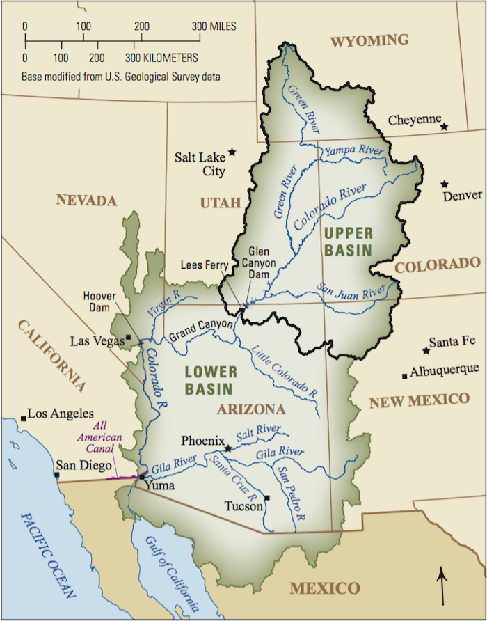
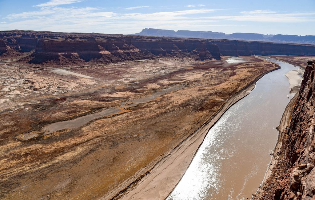
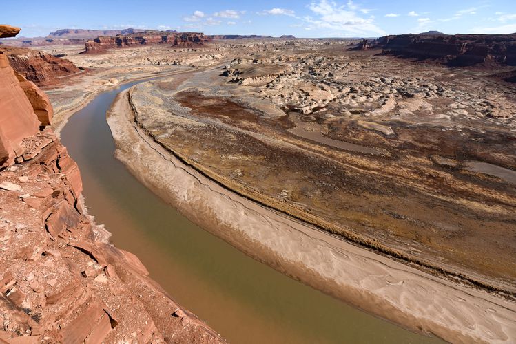
Utah politicians and water officials have for years insisted that there is ample water in the Colorado River to fill its planned 140-mile Lake Powell pipeline to St. George in the southwestern corner of the state.
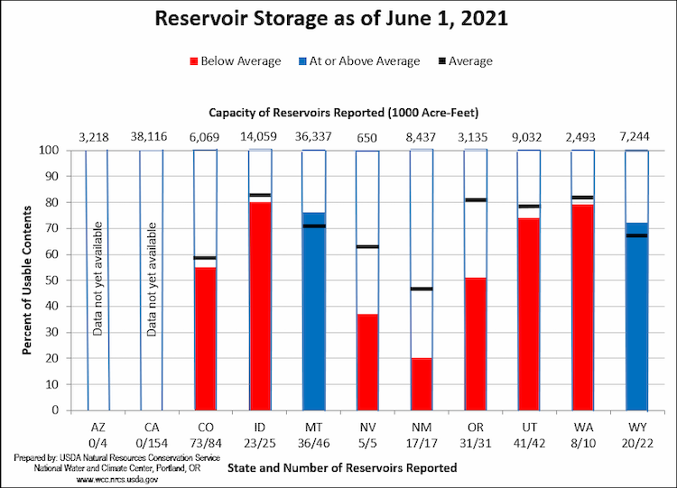
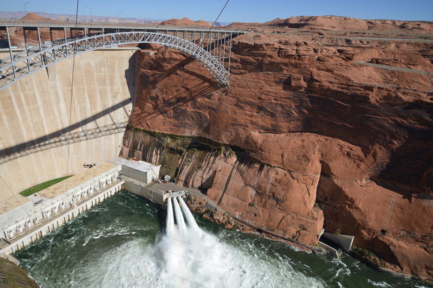
Despite impacts from climate change that have resulted in an 18% decline in river flows during the past two decades and a drop in Lake Powell’s level to just 35% of capacity, they might just be right.
Utah’s consistent argument that it has nearly 400,000 acre-feet (roughly 130 billion gallons) of undeveloped water in the river is disputed by hydrologists who say it’s using all its allotted share under the 1922 Colorado River Compact. Even so, legal experts and engineers point out that there could be room for additional development — if the state is willing to buy or take the water from someone else.
“If there is going to be a new pipeline,” Eric Kuhn, former general manager of the Colorado River District, said in an interview, “let’s not pretend that it’s going to be using new water. If they build a new pipeline, they’re going to get that from irrigation water.”
The most likely candidate is irrigation water from the Uinta Basin, said Kuhn, co-author of “Science Be Dammed: How Ignoring Inconvenient Science Drained the Colorado River.”
And that is exactly what Utah plans to do.
There’s one problem: The water the state plans to tap for the Lake Powell pipeline was previously promised to the Ute Indian Tribe, which is now suing to get back its water and asserting that the misappropriation is one of a decades-long string of racially motivated schemes to deprive it of its rights and property.
Pulling the plug on the Central Utah Project
The dispute dates to the 1950s and the origins of the Central Utah Project (CUP), a series of pipelines and reservoirs that channels Colorado River water over the Wasatch Mountains to Utah’s population centers in Salt Lake and Utah counties.
Utah water managers at the time leveraged Ute tribal water rights to cut a deal for construction of the CUP. In exchange for the destruction of lands and fisheries essential to the Ute way of life, state and federal governments agreed to extend the project to tribal lands.
But once the first phases of the project were complete, Utah and its federal partners abandoned plans to build dams and pipelines for the Utes, citing excessive costs and underwhelming benefits.
“It is unclear why the costs and benefits varied so significantly,” the tribe’s 2020 federal lawsuit said, referring to the completed CUP phases delivering water to the Wasatch Front compared to the originally proposed tribal phases. “However, it is clear that as an exclusively tribal project — that is, as a project for the delivery of the Tribe’s Reserved Water Rights — [the Bureau of Reclamation] found poor economics, but when non-Indians were included as part of the project, the economics drastically improved.”
These decisions significantly curtailed the tribe’s expected economic benefits from the project, guaranteeing it would not grow as quickly as other communities that received CUP water, the complaint said. It cited, for example, a 2018 attempt by the tribe to enter into a contract with an oil and gas development company, which ultimately fell through because the tribe lacked access to sufficient water to make the project happen.
Moreover, in what the tribe sees as an illegal betrayal and violation of its rights, the state has reassigned the promised water to a variety of other projects, including the Lake Powell pipeline.
Starting in 1996, the Utah Board of Water Resources divvied up the unused CUP water, awarding tens of thousands of acre-feet to the Uintah Water Conservancy District, the Duchesne County Water Conservancy District, and other public and private water developers. Two final divisions plan to split the remainder. Roughly 86,000 acre-feet will be assigned to the 140-mile Lake Powell pipeline — a $1 billion-plus project that still awaits federal approval — and the last 72,641 acre-feet of water has been allotted to a conservation and storage project called the Green River Block.
In a statement to The Utah Investigative Journalism Project, the tribe called the approval of the Green River Block a “sham contract” that lacks “any legal authority.”
According to the tribe’s 2020 federal lawsuit, which names the Green River Block specifically but does not include the as-yet unfinalized Lake Powell pipeline transfer, Utah appears to derive its claimed authority to execute these transfers from the Central Utah Project Completion Act of 1992.
The congressionally approved compact, which required ratification of the state and Ute Tribe, has never won approval of the Utes, rendering it null and void in their eyes. The state Legislature only recently endorsed it.
The act, while promising protection for the tribe’s water rights and future financial compensation for economic losses associated with the incomplete portion of the CUP, said the Bureau of Reclamation no longer would fund the construction of pipelines and dams needed to store and access the water — a provision unacceptable to the tribe.
State moves forward despite tribe’s objections
In 1996, even as the Utes were still trying to negotiate a deal to help pay for the needed infrastructure, the bureau determined that the pledged water had not been put to beneficial use and deeded it to the Utah Board of Water Resources. This transfer took place, the tribe told The Utah Investigative Journalism Project, “without any prior notice to, or consultation with, the Tribe.”
Representatives from the Utah Division of Water Resources declined to answer questions about their stance on the Central Utah Project Completion Act and related water transfers, citing the tribe’s lawsuit against the state and a hearing scheduled for later this month.
When Utah lawmakers in 2018 finally decided to officially ratify and put into statute the congressional compact, state leaders were aware that the tribe objected to it but chose to move forward with SB98 regardless, records show. A month before the final legislative passage, the tribe sent a letter to then-Sen. Kevin Van Tassell, the bill’s sponsor, to express its view that the terms of the compact were “unacceptable to the Ute Indian Tribe in that it was substantially amended without any input from the Tribe.” The only saving grace of the congressional action that created it, the letter said, was that Congress “made the compact contingent upon ratification by the Ute Tribal members before it became a valid document.”
“We therefore request that your bill be withdrawn until such time as the Ute Tribe and the state of Utah have come to a compromise on the water compact that can be approved by both the state of Utah and the Ute Tribe and its members,” Ute Tribal Business Committee Chairman Luke Duncan wrote to Van Tassell.
Van Tassell responded in a letter dated Feb. 27, 2018, saying he had asked the tribe for proposed amendments to the compact that would address its concerns and expressed disappointment that it had not done so. He said he intended to move ahead with his bill.
“Please know I’m happy to continue to work with you and the rest of the Ute Tribal Business Committee throughout this year to improve the statute and address your concerns,” he wrote the same day the bill cleared its first Senate vote.
A few days earlier, Christine Finlinson, assistant manager of the CUP, appeared before a Senate committee to endorse SB98. “We’re anxious,” she said, “to have this part of our history concluded.”
The bill passed the Legislature without a dissenting vote — and with no testimony from any member of the tribe.
‘Beneficial use’ water doctrine has religious underpinnings
The notion that water should be assigned not according to wealth or power but according to a community’s ability to put water to socially beneficial use dates back to Brigham Young and his oversight of Mormon settlement in Utah in the 1800s.
This principle ostensibly prevented any one party from exercising monopoly control over natural resources. But Young’s assertions also provided a convenient way for white settlers to ignore Native American claims to land and water, according to W. Paul Reeve, the head of Mormon studies at the University of Utah.
“It’s not just a conflict over resources; it’s values,” Reeve said. “Young said he didn’t believe the land belonged to anyone, it belonged to the Lord, and therefore it was there for anyone to use. It was a theological way of sidestepping Native Americans’ claims to the land and Native American cosmologies in which their creation stories suggest that their gods gave them the land.”
White settlers went on to use this theology to settle the best-watered valleys and to assign themselves ever-larger portions of the state’s water and farmland, even though Utah’s native populations also practiced agriculture and irrigation long before white settlement. State leaders did not believe native communities were as efficient or productive in their use of natural resources, according to Reeve, because their systems were not based in the Americanized ideal of homestead-based agriculture that Thomas Jefferson envisioned as key to self-sufficiency and true individual freedom.
This practice of assigning natural resources to the user who achieved the greatest “benefit” gradually eroded native control of the state’s natural resources. In a matter of years, Native Americans went from controlling 100% of the lands now considered Utah, to controlling just 4%, said Reeve, author of the book “Religion of a Different Color: Race and the Mormon Struggle for Whiteness.”
“The narrative Latter-day Saints would tell is we came West and we conquered an inhospitable environment. We took land that was inhospitable and made it blossom,” Reeve said. “So when you see all the green lawns in this semiarid environment, it’s 21st-century Latter-day Saint attitudes of continuing that conquest of a desert environment.”
The fact that southern Utah, the most inhospitable of all Utah environments, is now experiencing a housing boom that prompts the construction of a Lake Powell pipeline is a remarkable testament to that pioneer legacy, Reeve said. But framing that legacy as solely a conquest of a landscape “completely ignores the fact that the development and the settlement came at the expense of native peoples.”
“All those things factor into how this unfolds,” Reeve said. “It’s part of how we’re going to solidify the conquest of our ancestors, by building this pipeline.”
Utes seek a seat at the table
After the Ute Tribe watched the Utah Legislature act unilaterally to try to solidify and codify the never-ratified compact of 1992, it decided to pursue another avenue for defending its rights on the Colorado River. A few months after SB98 passed and was signed by then-Gov. Gary Herbert, Chairman Duncan sent a letter to the Upper Colorado River Basin Commission seeking appointment of a tribal representative to the body.
“We have studied the law of the Colorado River and its management, and we conclude that there will never be effective management of the river unless the Commission establishes a relationship with the Ute Tribe,” Duncan wrote in the July 24, 2018, missive. “This relationship must recognize that the Tribe has a sovereign, governmental interest in its apportionment of water in the Colorado River Basin with senior, reserved water rights that are held in trust by the United States for the Tribe, as the beneficial owner of these water rights.”
The letter requested a meeting at Ute Indian tribal headquarters in Fort Duchesne. Amy Haas, executive director of the commission, subsequently forwarded the letter to other members, saying she was suggesting some alternative locales. She signed off with a sarcastic quip: “Good thing we have nothing else going on!”
Representatives from the tribe met in December of that year with commissioners in Las Vegas. In his report back to the Utah Division of Water Resources, Eric Millis, then-division director and Utah’s representative on the river commission, noted the tribe’s request for its own member but disagreed with its argument.
“The Upper Basin states — Wyoming, Colorado, New Mexico and Utah — believe that any tribe within any of the states’ boundaries are already and best served by their state representative on the Colorado River,” Millis wrote to his colleagues. “For the Ute Tribe, that is Eric Millis, Utah’s Upper Colorado River Commissioner. This has been expressed to the Tribe.”
(Gene Shawcroft, who was appointed in January by Gov. Spencer Cox to replace Millis as Utah’s Upper Colorado River commissioner, did not respond to questions regarding his position on the tribe’s request.)
Not surprisingly, the tribe had a different view:
“State representatives are not in a position to represent tribal interests, which is largely why we continue to face issues related to Indian water rights recognition, development, and water management today. … Time and time again, we are made aware of situations and decisions where the Tribe is not involved in discussions which have direct implications for our most valuable tribal trust resource — water.”
The Water Desk’s mission is to increase the volume, depth and power of journalism connected to Western water issues. We’re an initiative of the Center for Environmental Journalism at the University of Colorado Boulder. The Water Desk launched in April 2019 with support from the Walton Family Foundation. We maintain a strict editorial firewall between our funders and our journalism.