An initiative of the Center for Environmental Journalism at the University of Colorado Boulder

Home Blog Page 17

A mud-caked “terra incognita” emerges in Glen Canyon as Lake Powell declines to historic low

From left, Mike DeHoff, Eric Balken and Pete Lefebvre walk near the mouth of White Canyon, a previously inundated area, now exposed as Lake Powell recedes. Alex Hager / KUNC.

By Luke Runyon

Water Desk Grantee Publication

This story was supported by the Water Desk’s grants program.

Learn more about our grants for journalists

Read more grantee stories »

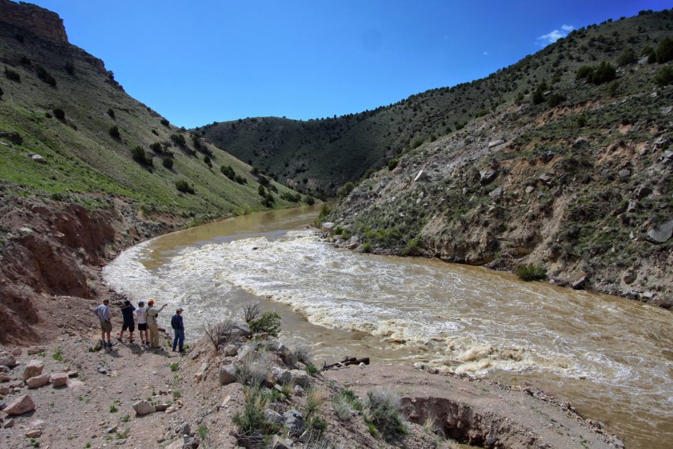
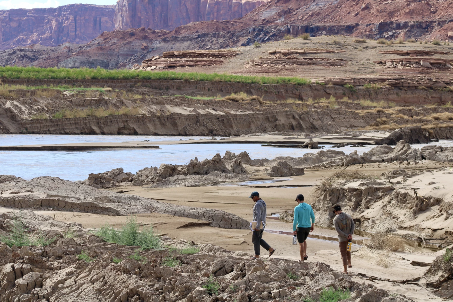
On a scorching July afternoon, Mike DeHoff steered his small metal motorboat down what one could argue is the weirdest stretch of the Colorado River in all of its 1,450 miles: the delta of Lake Powell.

DeHoff’s boat floated on roiling water supercharged with sediment, the same color as an iced latte. Craggy, gnarled mud formations rose up from the river channel. Rapids made of mud, which change their contours by the hour, tossed the boat from side to side.

“I mean, look at this,” DeHoff said. “It’s like boating through what you think Mordor would look like.”

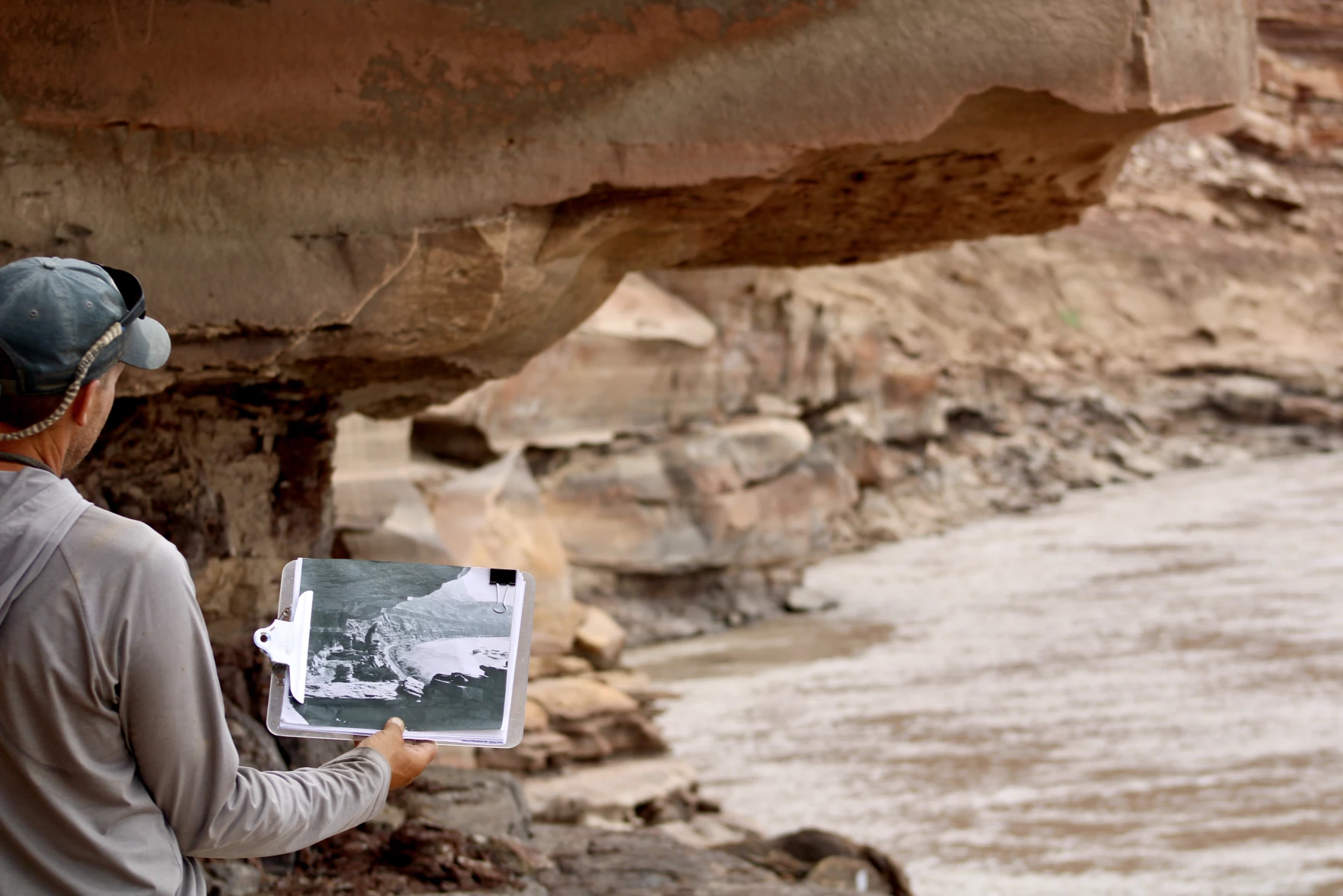
Winds whipped up dirt and fine sand from giant, dried-out mud flats, spilling more sediment back into the river. Whole slabs of mud cleaved themselves clean off, like a calving glacier. One attempt to climb up the sediment-caked canyon walls by this reporter and his photographer nearly triggered a dirt avalanche big enough to bury a person. In the delta, the river’s water appeared so thick with sediment that it threatened to turn back into mud at any moment.

A rafting outfitter motors through Lake Powell's delta. Alex Hager / KUNC
A rafting outfitter motors through Lake Powell’s delta. Alex Hager / KUNC

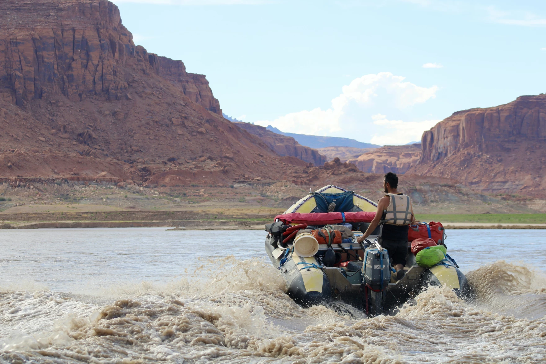
The launch point for this trip, an access area called North Wash, near Hite, Utah, is so steep and unstable that rafting outfitters have to use complex winch and pulley systems just to get boats out of the river. It can’t really be called a boat ramp with a straight face, DeHoff said. The chaos created by a receding reservoir caused the Colorado River to jump its channel, and begin carving away at the ramp.

Lake Powell’s delta is the place where the flowing Colorado River meets the stillwater reservoir. And it moves, depending on the year. The river’s flow and the reservoir’s elevation dictate where they meet. It is a “no man’s land,” as DeHoff called it, between the whitewater rapids of Cataract Canyon and the motorboater’s paradise of Lake Powell.

This trip was an investigatory one for DeHoff, a longtime river runner who’s spent decades rafting down Cataract. Features long hidden underwater were on the surface, and he wanted to see them.

For the last five years, with a few partners, DeHoff has run a project called Returning Rapids, an attempt to document the change that comes as the nation’s second-largest reservoir plummets to a record low.

Mike DeHoff of Returning Rapids matches a historic photo taken near the mouth of White Canyon to see how far Lake Powell has dropped. Alex Hager / KUNC.

DeHoff piloted the boat around what he dubbed “mud-bergs,” like icebergs, but made of the claylike mud that collected at the bottom of Lake Powell for decades.

“The mud-bergs that we see defining and changing the river corridor, they change day to day, month to month,” DeHoff said. “And that’s a terra incognita for me.”

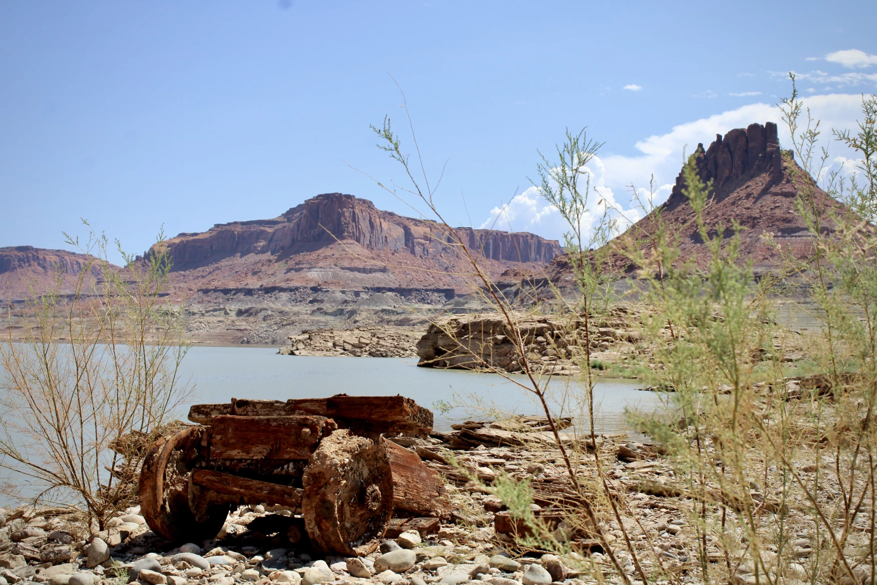
When the reservoir was full back in the 1980s and 1990s, this delta would have been deep underwater. With the reservoir at a historic low, more than ever before, that lake bottom is exposed. With the force of gravity behind it, the Colorado River is just doing what it does best: carving canyons.

Though, instead of the grandeur of the Grand Canyon, on this trip DeHoff took us through a mini-canyon of mud at the edge of Lake Powell.

“This is like a river on an acid trip right now,” he said.

Mudbergs rise up from the Colorado River’s channel as it flows into the still waters of Lake Powell.

A new historic low

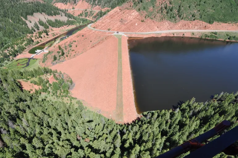
For decades the Colorado River filled Glen Canyon to the brim. Lake Powell has been a fixture of the southwest since the 1960s, providing hydropower to southwestern utilities, water supply reliability to downstream users, and summer vacation memories to families on houseboats.

Over its lifespan, the reservoir’s level has fluctuated wildly, driven by the massive piles of snow that gather in the Rocky Mountains each winter and melt off in the spring.

Since Glen Canyon Dam was commissioned in 1964 and it first began filling, Lake Powell has never been like it is right now, at just 27% of its capacity. It’s threatening to dip below the minimum elevation needed to produce hydropower within the next year. A string of dry winters could push it to dead pool status.

An ore cart, encrusted in invasive mussel shells, rests on a ledge above a receding Lake Powell. Alex Hager / KUNC.

The megadrought plaguing the Colorado River basin has splashed across national and international headlines as the river’s two main reservoirs, Lake Mead and Lake Powell, hit new historic lows. Combined, their dwindling levels leave the water supply for tens of millions in the Southwestern U.S. uncertain. The current crisis garnered attention from the UN’s Environment Program, which warned of water and energy shortages without action.

Prompted by low reservoir levels, the Bureau of Reclamation has called for an unprecedented amount of conservation, two to four million acre-feet over the next year, to preserve current levels at the reservoir. The agency’s leader, Camille Calimlim Touton, threatened the seven states that rely on the Colorado River with unilateral action in absence of a commitment to conserve.

This summer, Lake Powell hit a high point of 3,539 feet in elevation. It is now on a long, slow decline until it receives another rush of snowmelt in spring 2023. As it declines, the reservoir’s upper reaches and its famous side canyons long buried underwater, are reemerging. River runners, scientists, environmentalists and journalists are rushing in to document the rapid change.

Even as problems mount at Lake Powell, DeHoff and others see this moment with a certain kind of somber optimism. They say if the region’s leaders frame it in a certain way, the reservoir’s decline could be viewed as hopeful, not catastrophic.

Camping on the Colorado

On a beach nestled inside Glen Canyon, DeHoff took a seat in a wooden fold-up chair next to Pete Lefebvre, a longtime river guide. This was camp for the night after boating through mud-bergs, a narrow stretch of sand close to the mouth of Trachyte Canyon, also formerly inundated as part of Lake Powell.

“This is the first time we’ve camped along the Colorado River, where it’s flowing in what would be Glen Canyon proper,” DeHoff said.

Mike DeHoff and Pete Lefebvre of Returning Rapids document the changing levels of Lake Powell, and how it affects Cataract Canyon upstream. Alex Hager / KUNC.

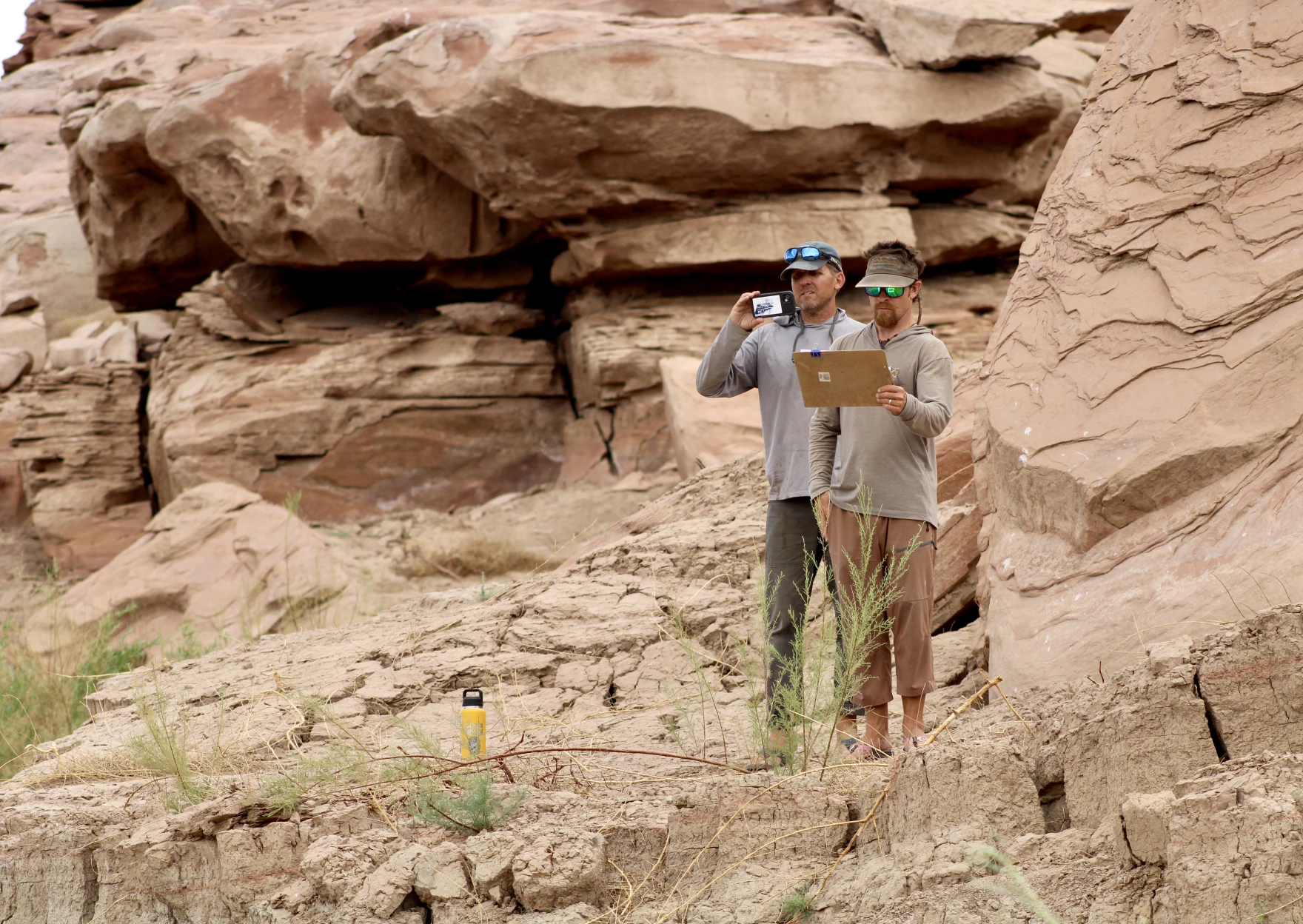
The two men work together on Returning Rapids out of their home base in Moab, Utah. The project has started installing time-lapse cameras to watch erosion happen in real-time and get a sense of when mud-buried river rapids will be unearthed.

Early on, Lefebvre said they found that asking one admittedly selfish question — “where can we go rafting?” — led to asking dozens more about sediment movement, water supply, hydropower production and the future of recreation.

“We just didn’t even expect to be studying this area the way that we are right now,” he said of the reservoir delta. “Just because of how fast the river is moving downstream and the lake is dropping.”

The federal government has recently pulled emergency levers to prop up Lake Powell, sending more water from upstream reservoirs and restricting releases from Glen Canyon Dam. With warming temperatures sapping snow in the Rocky Mountains and downstream demands for water going unchecked, Lefebvre said it feels like the whole Colorado River basin is at a breaking point.

“I just think that we don’t, as a species, react until it’s like, ‘Oh man, we need to do something,’” he said. “We’re getting to the point where people are saying, ‘Man, we need to do something.’”

As the region grapples with how to use less Colorado River water, this is the place where those decisions show up on the ground, Lefebvre said.

“Until there’s a scarcity of water, I don’t think people treat it like it is the most important resource we have,” he said. “Being subsidized, being cheap, allows us to act frivolously with it and I think that’s possibly going to change in the future as we get squeezed.”

A side canyon sensory experience 

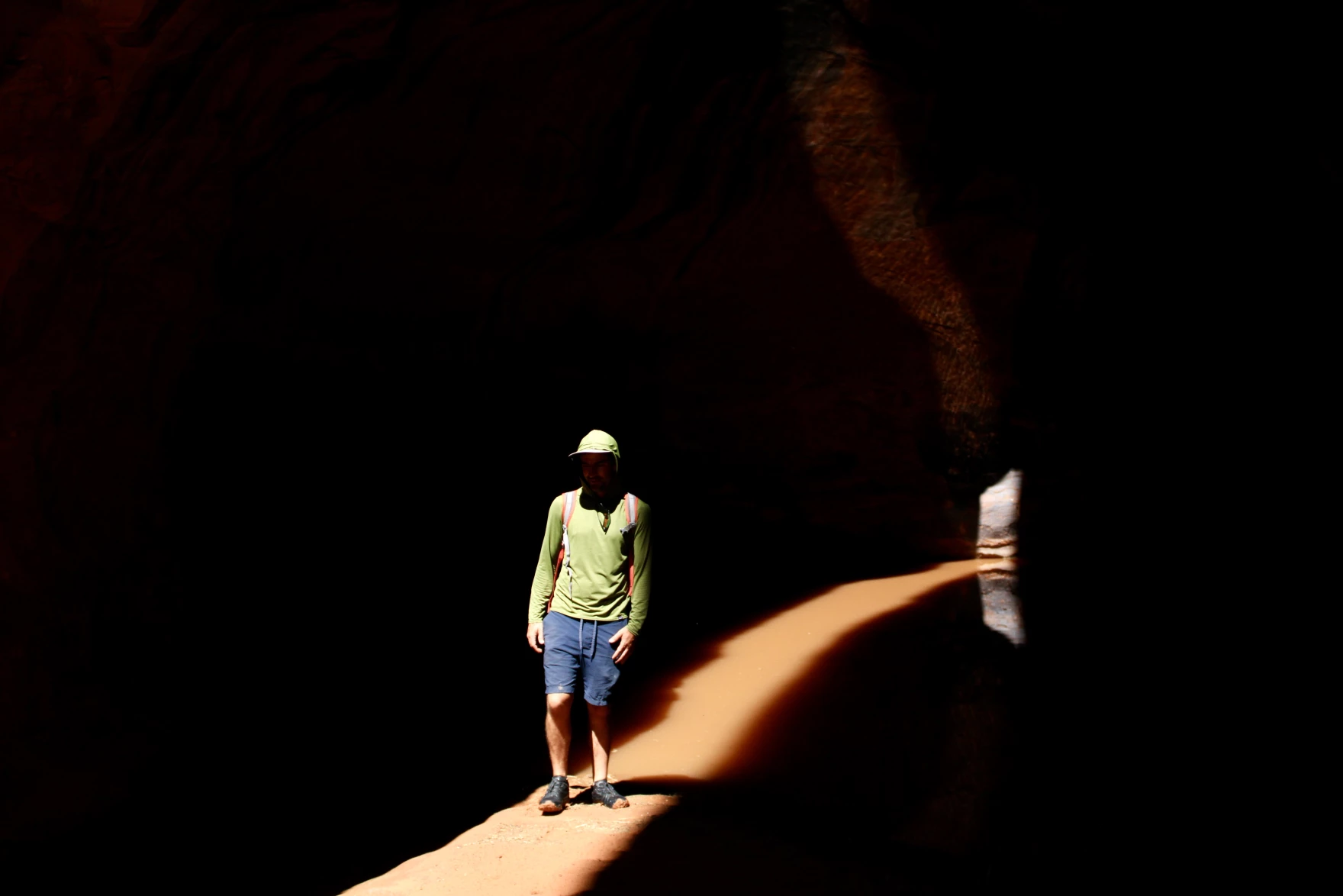
The next day, the boats rolled into Lake Powell and veered up into one of its many side canyons. Years ago, when the reservoir was full, a boat could continue up for miles into this narrow canyon. Now the low level forces boaters off at a narrow sand bar and requires a hike up to see any natural wonders that await.

Dead cottonwoods, long buried under the still waters of Lake Powell, have reemerged as "ghost forests." Alex Hager / KUNC.
Dead cottonwoods, long buried under the still waters of Lake Powell, have reemerged as “ghost forests.” Alex Hager / KUNC.

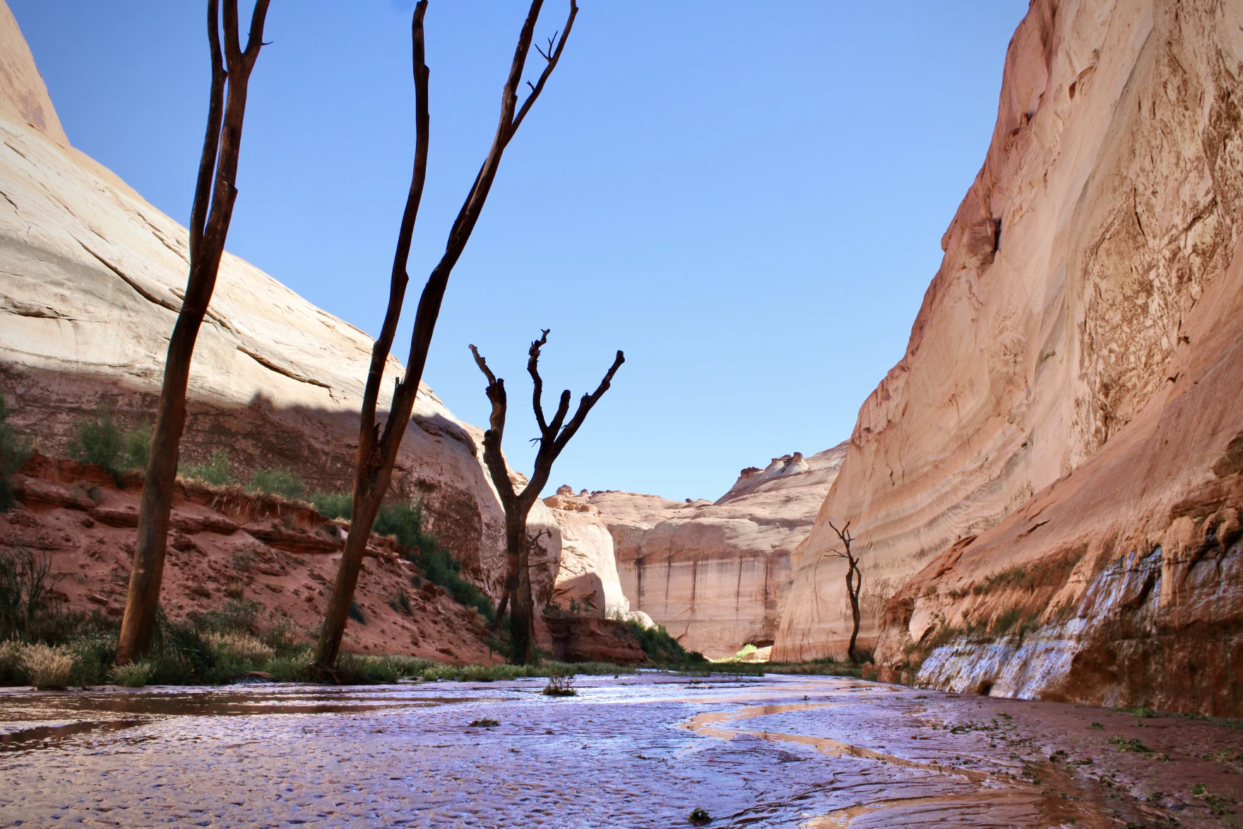
This canyon featured a forest of formerly underwater cottonwoods, flooded during the reservoir’s initial rise in the late 1960s and preserved in place at its bottom. They now stand darkened and dead among vibrantly green regrowing vegetation. A shallow flowing creek full of tadpoles winds its way through the canyon. Willows line its banks and play host to an insect symphony.

“Oh, man, that smell,” said Eric Balken, as he led a group up the canyon, inhaling deeply. “The willows smell so alive.”

Balken runs the Glen Canyon Institute, which advocates draining Lake Powell and moving what’s left of its waters downstream. DeHoff and Lefebvre’s Returning Rapids is a project underneath the Institute’s umbrella. Balken pointed out a high water mark from the reservoir stained on the redrock one hundred feet or more above our heads.

“There are a lot of big changes coming to the Colorado River,” he said. “And this is one that’s a good change. To see this canyon come back is really special.”

Eric Balken, of the Glen Canyon Institute, walks past a sunken speedboat in a side canyon in Glen Canyon National Recreation Area. Alex Hager / KUNC.

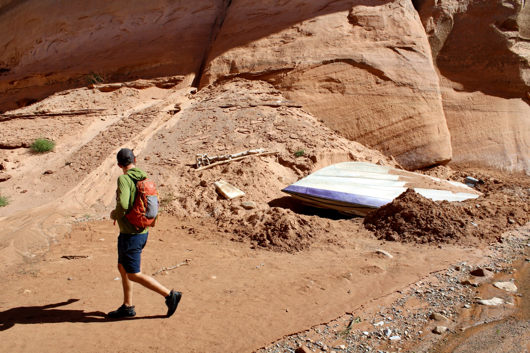
The hike yielded artifacts from when the reservoir still inundated this canyon — four pairs of sunglasses, empty beer cans, a life jacket, a sunken speedboat half-buried in the sand.

Groups like Balken’s want to see Lake Powell’s dam decommissioned and Glen Canyon behind it restored. Balken says this current moment of reckoning on the river, where users are collectively trying to figure out how to use less, should be seen as an opportunity. Lake Powell was built to hedge against lawsuits among the river’s Upper and Lower Basins and ensure a legally-required amount of water flowed downstream. Many of the legal concepts and engineered systems used to manage this river system are woefully out of date, Balken said. A crisis like this one can be a powerful motivator to change, he said.

“Now we’re being given a chance to rethink this place. The reason why it was a mistake was because it had so much value beyond a storage tank,” he said. “We should prioritize water storage elsewhere. We should stop thinking about Glen Canyon as a place to store water and start thinking about it as a place that has natural values, intrinsic values.”

Eric Balken of the Glen Canyon Institute hikes through a narrow slot canyon. Alex Hager / KUNC.

Balken said the federal government and the states who rely on Lake Powell for storage need to be planning for a future without it. Climate change and its ability to warm up and dry out the southwest will continue to put pressure on the reservoir. In the very near future, he said, it might not be feasible to keep Lake Powell in operation for hydropower and recreation. A failure to plan for a very low reservoir, and instead rely on optimistic models that show possible recovery, could put the water supply for downstream users in jeopardy.

“We need to think about what conditions would it actually make sense to fully phase this reservoir out,” he said. “It’s hard for people to imagine right now, but once you can’t come here for your houseboat vacation anymore, once it’s not generating any more hydropower,” it’s easier to begin reconsidering Lake Powell’s usefulness.

Balken noted that his organization’s views were until very recently seen as fringe among the West’s water elite. Now national news outlets have showcased Glen Canyon’s wonders reemerging. He’ll even run into boaters, those who will need to find a new place to dock their houseboat if Balken’s dream is realized, who tell him how fascinating it is to watch the canyon emerge from the water after being buried underneath it.

“It’s encouraging for me,” Balken said. “While also being mindful of the fact that the fabric of western water management is coming apart at the seams.”

This story is part of ongoing coverage of the Colorado River, produced by KUNC and supported by the Walton Family Foundation. This article was also supported by The Water Desk, an independent journalism initiative based at the University of Colorado Boulder’s Center for Environmental Journalism.

The Water Desk’s mission is to increase the volume, depth and power of journalism connected to Western water issues. We’re an initiative of the Center for Environmental Journalism at the University of Colorado Boulder. The Water Desk launched in April 2019 with support from the Walton Family Foundation. We maintain a strict editorial firewall between our funders and our journalism.

Grizzly Reservoir to be drained next summer for rehab work

Grizzly Reservoir will be drained next summer for a rehabilitation project on the dam, tunnel gates and outlet works. The reservoir serves as the collection bucket for water from the surrounding drainages before it’s diverted through the Twin Lakes Tunnel to the Front Range. CREDIT: HEATHER SACKETT/ASPEN JOURNALISM
Grizzly Reservoir will be drained next summer for a rehabilitation project on the dam, tunnel gates and outlet works. The reservoir serves as the collection bucket for water from the surrounding drainages before it’s diverted through the Twin Lakes Tunnel to the Front Range. CREDIT: HEATHER SACKETT/ASPEN JOURNALISM

By Heather Sackett

Grizzly Reservoir, the high-mountain lake above Aspen formed by damming Lincoln and Grizzly creeks, will be drained next summer for repairs to the dam, tunnel and outlet works.

After spring runoff next year, Twin Lakes Reservoir and Canal Company will draw down the reservoir so workers can install a membrane over the steel face of the dam, which was constructed in 1932 and is corroded and thinning, according to a May report on the feasibility of the dam rehabilitation.

The report, by RJH Consultants, Inc. of Englewood, included an inspection and evaluation of the infrastructure, and presented different options for rehabilitation. Half the cost of the study — $50,000 — was funded by the Colorado Water Conservation Board.

The project will also replace the gates that control the flow of water into the Twin Lakes Tunnel and repair the outlet works that release water down Lincoln Creek. According to the report, the outlet works have issues with cracks, holes and seepage, and the more-than-80-year-old tunnel gates have problems with leakage, are difficult to operate and require significant maintenance every year.

“The purpose of the rehabilitation of the dam is to address dam safety concerns associated with the corroded and thinning upstream-slope steel facing, uncontrolled seepage, and operational problems with the outlet works,” the report reads.

Twin Lakes officials expect the project to be completed in October 2023. They will also draw down the reservoir this month to weld a small test portion of the dam membrane to see how it fairs through the harsh winter at 10,500 feet. That work is scheduled to begin Aug. 22 and the reservoir will be refilled in October.

“That infrastructure is aging and it’s time to do some rehab work on it,” said Twin Lakes Reservoir and Canal Company Board President Kalsoum Abbasi.

Grizzly Dam is considered a high hazard dam by the Division of Water Resources. That does not mean it’s likely to fail, but it means loss of life would be expected if the dam did fail. The last state inspection in 2021 found the dam satisfactory — the highest rating — and said full storage capacity was safe.

The report estimated a nearly $7 million price tag for the rehabilitation work. Twin Lakes plans to get a CWCB loan for some of the cost and will pay the remainder with money raised from assessments on its water users.

Kalsoum Abbasi, the president of the Twin Lakes Reservoir and Canal Company, explains how the water collection system works at a July tour of Grizzly Reservoir. The system is the biggest supplier of Western Slope water for the city of Colorado Springs.
CREDIT: HEATHER SACKETT/ASPEN JOURNALISM
Kalsoum Abbasi, the president of the Twin Lakes Reservoir and Canal Company, explains how the water collection system works at a July tour of Grizzly Reservoir. The system is the biggest supplier of Western Slope water for the city of Colorado Springs.CREDIT: HEATHER SACKETT/ASPEN JOURNALISM

Twin Lakes system

Grizzly Reservoir is part of a complex system of storage buckets, tunnels and canals that takes water from the headwaters of the Roaring Fork River basin under the continental divide and delivers it to Front Range cities. The system collects runoff from 45 square miles of mountainous terrain, including the New York, Brooklyn, Tabor, Lincoln, Grizzly and Lost Man creek drainages and dumps it into Grizzly Reservoir, which can hold 570 acre-feet of water.

From there the water flows into the 4-mile-long and straight-as-a-pin Twin Lakes Tunnel under the Continental Divide and into Lake Creek, a tributary of the Arkansas River. Twelve miles later the water arrives at the Twin Lakes Reservoir where it is stored before being sent to Front Range cities via pipelines and pumps.

Four municipalities own 95% of the shares of Twin Lakes water: Colorado Springs Utilities owns 55%; the Board of Water Works of Pueblo has 23%; Pueblo West Metropolitan District owns 12% and the City of Aurora has 5%.

The Twin Lakes system is so integral to the cities’ water supply that they employ two caretakers to live year-round in a cabin at the remote reservoir site to make sure everything operates smoothly. It’s Colorado Springs’ largest source of Western Slope water and represents about 21% of its total water supply.

The project is able to divert up to 46,000 acre-feet annually, or nearly 40% of the flows in the Roaring Fork headwaters, according to numbers from the Roaring Fork Conservancy. In recent years, Twin Lakes has diverted between about 31,000 and 38,000 acre-feet annually, according to data from the Colorado Division of Water Resources.

During next year’s rehabilitation work most of the creeks — Lost Man, New York, Brooklyn and Tabor — will be allowed to flow downstream instead of being collected by a canal system that feeds Grizzly Reservoir. As long as the water rights are in priority, Twin Lakes will probably still take and send through the tunnel whatever flows they get from Lincoln and Grizzly creeks, according to Abbasi. This means a stretch of Lincoln Creek below the dam will be dry.

When irrigators in the Grand Valley place the Cameo call, which happens most summers and often commands the entire Colorado River and its tributaries upstream, those with junior water rights have to stop diverting so irrigators can get their share. That’s because under Colorado water law the oldest water rights have first use of the river and Cameo’s right is older than Twin Lakes’.

“As long as we are in priority, we can still bring some water through the tunnel,” Abbasi said. “Whatever is making it into the reservoir, we will have a way to route that through the tunnel for the majority of the project.”

Abbasi said overall, Twin Lakes will probably divert less water than normal in 2023.

This dam backs up water from Lost Man Creek so it can flow into a canal and into Grizzly Reservoir. The reservoir is part of the Twin Lakes Reservoir and Canal Company infrastructure that moves water from the headwaters of the Roaring Fork River to the Front Range.
CREDIT: HEATHER SACKETT/ASPEN JOURNALISM
This dam backs up water from Lost Man Creek so it can flow into a canal and into Grizzly Reservoir. The reservoir is part of the Twin Lakes Reservoir and Canal Company infrastructure that moves water from the headwaters of the Roaring Fork River to the Front Range.CREDIT: HEATHER SACKETT/ASPEN JOURNALISM

Pitkin County’s stored water

Once work begins on the dam next summer, there will probably be more water flowing in the upper Roaring Fork above Aspen when the creeks that usually flow into Grizzly are allowed to go downstream. But there will also be a 200-acre-foot hole where water stored by Pitkin County won’t be released.

As part of a 2018 water court settlement, Pitkin County received 800 to 1,000 acre-feet of water from the Twin Lakes system, which is sent downstream instead of to the Front Range. Two hundred acre-feet of that can be stored in Grizzly Reservoir to release during the late summer.

“The rationale for Pitkin pushing for that was that’s when we tend to need the water the most,” said Laura Makar, assistant Pitkin County Attorney. “That’s when flows matter and every cfs makes the biggest difference.”

This year, the county used the 200 acre-feet to help boost streamflows between the end of spring runoff and when the Cameo call came on this week.

“We timed it perfectly so there’s no hole in the river,” Makar said. “The fish and river got the full benefit. We could sort of nurse the river along until the Cameo call came on.”

But next year, releasing the 200 acre-feet of stored water won’t be possible since there won’t be any water in Grizzly Reservoir during the late summer.

“It sounds like next year we will be limited to whatever exists naturally in the system,” Makar said. “We are making sure that when we plan for next year, we are ensuring we get the full benefit… but knowing we won’t have 200 acre-feet in late season releases that could actually come from the reservoir.”

Aspen Journalism covers rivers and water in collaboration with The Aspen Times. This story ran in the Aug. 14 edition of The Aspen Times.

The Water Desk’s mission is to increase the volume, depth and power of journalism connected to Western water issues. We’re an initiative of the Center for Environmental Journalism at the University of Colorado Boulder. The Water Desk launched in April 2019 with support from the Walton Family Foundation. We maintain a strict editorial firewall between our funders and our journalism.

West Slope water managers ask: What authority do the feds have?

Houseboats on Lake Powell on Dec. 13, 2021, near Wahweap Marina, where the quarter-mile-long boat ramp is unusable due to low water levels. The Bureau of Reclamation Commissioner has said 2 to 4 million more acre-feet of conservation is needed to protect the system, leaving water managers wondering what authority the feds have over upper basin water projects. CREDIT: HEATHER SACKETT/ASPEN JOURNALISM
Houseboats on Lake Powell on Dec. 13, 2021, near Wahweap Marina, where the quarter-mile-long boat ramp is unusable due to low water levels. The Bureau of Reclamation Commissioner has said 2 to 4 million more acre-feet of conservation is needed to protect the system, leaving water managers wondering what authority the feds have over upper basin water projects. CREDIT: HEATHER SACKETT/ASPEN JOURNALISM

By Heather Sackett

As the deadline approaches for the seven Colorado River basin states to come up with a plan to conserve water, some Colorado water managers are asking what authority the federal government has in the upper basin and which water projects could be at risk of federal action.

U.S. Bureau of Reclamation Commissioner Camille Touton sent water managers scrambling when she announced in June that they had a 60-day window to find another 2 to 4 million acre-feet of water to conserve or the federal government would step in to protect the system. With many reservoirs, transbasin diversion systems and irrigation projects in Colorado tied in one way or another to the Bureau of Reclamation, some are asking if the water in these buckets could be commandeered by the feds to make up the shortfall.

“I think that there’s probably a good argument that the Secretary (of the Interior) has some authority under those projects,” said Eric Kuhn, Colorado River author and former Colorado River Water Conservation District general manager. “The projects on the Western Slope and in the upper basin states that are owned by the federal government and are ultimately under the authority of the Secretary of the Interior, those are the projects at risk.”

There are many dams and reservoirs across Colorado that are tied to the Bureau of Reclamation’s 20th century building frenzy to impound water and “reclaim” arid regions through irrigation. On the Western Slope, some of the well-known projects include the Fryingpan-Arkansas Project (Ruedi Reservoir), Dallas Creek Project (Ridgway Reservoir), the Dolores Project (McPhee Reservoir), Paonia Reservoir, the Grand Valley Project, the Silt Project (Rifle Gap Reservoir), the Uncompahgre Project (Taylor Park Reservoir) and more.

In general, the local entities like conservancy districts, irrigators and municipalities who use the water are responsible for repaying the Bureau for the cost of the project. But the infrastructure is owned by the Bureau of Reclamation. Some projects are operated by Reclamation and some are operated by a local entity. Many also have a hydropower component.

“I think each project operator is having to look at their contractual obligations with the Bureau and their attorneys are going back over those with a fine tooth comb to see if the arm of the Bureau can reach up through Lake Powell and into the upper basin states,” said Kathleen Curry, a rancher and Gunnison County representative on the Colorado River Water Conservation District. “All of the upper basin projects are going to need to look real hard at what authority the Bureau has.”

Last year Reclamation made emergency releases out of Blue Mesa, Flaming Gorge and Navajo reservoirs to prop up Lake Powell. In this instance their authority was not questioned since these reservoirs are, along with Lake Powell, the four initial reservoirs of the Colorado River Storage Project. They store what’s called “system water,” which is used specifically to help the upper basin meet its delivery obligations to the lower basin.

But water managers still don’t know exactly what, if anything, Reclamation is allowed to do with the water contained in other reservoirs with Reclamation ties.

The crest of the dam across the Fryingpan River that forms Ruedi Reservoir, which can hold 102,373 acre-feet of water. Some Western Slope water managers are asking what authority the Bureau of Reclamation has over water projects with Reclamation ties in the upper basin.
CREDIT: PHOTO: COURTESY OF BUREAU OF RECLAMATION
The crest of the dam across the Fryingpan River that forms Ruedi Reservoir, which can hold 102,373 acre-feet of water. Some Western Slope water managers are asking what authority the Bureau of Reclamation has over water projects with Reclamation ties in the upper basin.CREDIT: PHOTO: COURTESY OF BUREAU OF RECLAMATION

No answers from officials

At the River District’s third quarterly board meeting in July, board members repeatedly tried to pin down answers from federal and state officials without much luck.

Montrose County representative and state Rep. Marc Catlin asked state engineer Kevin Rein where he stood on whether the Bureau of Reclamation could make reservoirs with Reclamation ties release water downstream to Lake Powell to meet the 2 to 4 million acre-feet conservation goal.

“If the Bureau of Reclamation comes into the state of Colorado and says it wants to move water… down to Lake Powell, what’s the state engineer going to do?” Catlin asked. “Are those water rights under state law or federal law?”

Rein did not know the answer.

“I’m not sure what authority — this is not one of those rhetorical ‘I’m not sure,’ I really am not sure — what authority the Bureau of Reclamation would have to induce a federal project with state water rights to release them to get to Powell,” Rein said.

Later in the meeting, Katrina Grantz, the Bureau of Reclamation’s Upper Colorado Basin Assistant Regional Director, gave a presentation and took questions from board members. Curry asked if changes could be proposed to the operation of projects within the 15 counties represented by the River District with federal ties to get closer to the 2 to 4 million acre-feet. Grantz side-stepped the question.

“At this point we are not looking at specific locations,” she said. “I would turn it around and say: Are there areas where you locally think there might be areas to conserve?”

River District General Counsel Peter Fleming said the authority of the feds in the upper basin is untested. This is partly because the upper basin has dozens of small Reclamation projects as well as thousands of individual water users on private ditch systems that are not affiliated with the federal government. Colorado has generally been left alone to administer this complex system of water rights under the state doctrine of prior appropriation, which means older water rights get first use of the river.

The lower basin, in contrast, has only about 20 diversions — and only six or so big ones — from the Colorado River. And each entity that uses water from Lake Mead has to have a contract with Reclamation, meaning the federal government is directly involved with water deliveries.

“The reason I think these issues are untested is historically the secretary’s role in the upper basin has been different than the secretary’s role in the lower basin,” Fleming said. “It’s much more hands-off. The difference in river administration is huge.”

Fleming said that the River District does not have advice for its water users on the situation, other than to reiterate the upper basin stance that the responsibility to come up with the 2 to 4 million acre-feet lies overwhelmingly with the lower basin.

“At the end of the day I think there will be a big effort to try to resolve things through agreement and I believe the secretary will exercise her authority to the greatest extent she can without triggering litigation,” Fleming said.

Water managers may not have to wait long to get some clarity. The deadline for the states to come up with a conservation plan before the feds take action to protect the system is fast approaching. The upper basin states, through the Upper Colorado River Commission, have put forward a 5 Point Plan, which lays out actions they say are designed to protect the reservoirs.

Amee Andreason, public affairs specialist with the Bureau of Reclamation, said officials may answer the question of federal authority in the upper basin at a media event on Aug. 16 that coincides with the release of the August 24-month study, which lays out reservoir operations for the following water year.

If the feds end up curtailing uses in the lower basin, it could set a precedent that would strengthen the argument that they can do the same in the upper basin, Kuhn said.

“That’s one I think is the elephant in the room,” he said. “The fact that the River District board was asking about authorities tells you people are thinking about it.”

This story was also published by the Sky-Hi News, Glenwood Springs Post Independent, Summit Daily News, Aspen Times, Vail Daily, Pagosa Springs Sun and KKCO 11 News.

The Water Desk’s mission is to increase the volume, depth and power of journalism connected to Western water issues. We’re an initiative of the Center for Environmental Journalism at the University of Colorado Boulder. The Water Desk launched in April 2019 with support from the Walton Family Foundation. We maintain a strict editorial firewall between our funders and our journalism.

Tourist haven Grand Lake asks state to intervene in federal water quality stalemate

A woman paddles on Shadow Mountain Reservoir, which is caught in federal stalemate over how to improve water quality to help improve its neighboring Grand Lake. Credit: Daily Camera

By Jerd Smith

Fourteen years after Colorado adopted standards to restore Grand Lake, the state’s largest natural water body once known for its astonishing clarity and high water quality continues to deteriorate.

Frustrated and worried about the future, Grand Lake locals are asking the state to intervene to break through a log jam of federal and environmental red tape that has prevented finding a way to restore the lake’s clarity and water quality, despite a 90-year-old federal rule known as Senate Bill 80 requiring that the work be done.

At issue: Grand Lake serves as a key element of Northern Water’s delivery system, which provides water to more than 1 million people on the northern Front Range and thousands of acres of irrigated farmlands.

Owned by the U.S. Bureau of Reclamation and operated by Northern Water, what’s known as the Colorado-Big Thompson Project gathers water from streams and rivers in Rocky Mountain National Park and Grand County, and stores it in man-made Lake Granby and Shadow Mountain Reservoir. From there it is eventually moved into Grand Lake and delivered via the Adams Tunnel under the Continental Divide to Carter Lake and Horsetooth Reservoir,  just west of Berthoud and Fort Collins respectively.

During that process, algae, certain toxins and sediment are carried into Grand Lake, clouding its formerly clear waters and causing algae blooms and weed growth, and harming recreation.

Created by Fresh Water News

In a hearing before the Colorado Legislature’s Interim Water Resources and Agriculture Review Committee on Aug. 4, Mike Cassio, who represents the Three Lakes Watershed Association in Grand County, pleaded with state lawmakers to intervene and launch a study process that would help trigger federal action.

“We have the highest respect for all of our partners,” Cassio said, referring to ongoing remediation efforts involving Northern Water and the U.S. Bureau of Reclamation.

“But due to the design of the system, you have this beautiful natural lake and then you fill it up with reservoir water. Usually, in July when spring runoff is going on, Grand Lake is flowing from east to west. It is extremely clear. But as soon as Shadow Mountain’s water sits and starts to cook and grow weeds and algae, and the pumps come on, this massive plume of nitrates, inorganics, just basic muddy water flows into Grand Lake,” Cassio said.

In 2008, the Colorado Water Quality Control Commission moved to set a clarity standard, but it has since been replaced with a clarity goal and the aim of achieving “the highest level of clarity attainable.” Instead of working under a regulated water quality standard, Northern Water and others have implemented different management techniques, including changing pumping patterns, to find ways to improve water quality in all three water bodies.

In 2016, the U.S. Bureau of Reclamation took the first steps required under the National Environmental Policy Act of 1969 (NEPA) to do the scientific and engineering studies and public hearings that would be required to fix the system. But Reclamation stopped the process in 2020, saying that it could not definitively establish any structural alternatives that would work, nor could it find a way forward on funding what could be a project that would cost hundreds of millions of dollars, according to Jeff Rieker, general manager of Reclamation’s Colorado Eastern Plains office.

During last week’s hearing, lawmakers said they want more information and that Northern Water’s system is too critical to the northern Front Range to do anything without careful consideration.

“We are in a moment of time like none other,” said State Rep. Hugh McKean, a Republican who represents Loveland and other northern Front Range communities. He cited the warming climate and the effects of the massive East Troublesome fire in 2020, which engulfed lands around the three lakes and created additional water quality problems, which still impact the watershed today.

“Is this the moment to create a long-term plan, when right now our water situation is in flux? I’m resistant to say let’s stop everything and study this,” McKean said.

But Grand Lake Mayor Steve Kudron disagreed.

“This is exactly the right time,” Kudron said. “Tourism impacts my community more than almost any other community in the state. One million people visited [Fort Collins’] Horsetooth Reservoir last year. Are we getting to the time when recreation on the East Side of the [Continental Divide] is more important than the West Side?”

Northern Water’s Esther Vincent told lawmakers at the hearing that management efforts have improved clarity somewhat. In 1941, before the Colorado Big Thompson Project began operating, clarity was measured at 9.2 meters, Vincent said.

“The [state’s] clarity goal is 3.8 meters,” she said. “We don’t hit it every year, but we’re doing a lot better. Over the past 17 years we’ve met the 3.8-meter goal 35% of the time and in the past five years we’ve hit the goal 60% of the time,” she said. “But East Troublesome complicates everything. We are still trying to wrap our heads around what this means for the system.”

Still, she said Northern was committed to finding a path forward and indeed is legally obligated to do so under the terms of its operating contract with Reclamation.

What that path may look like isn’t clear yet. Lawmakers did not recommend any action in the form of bills to authorize a study after Thursday’s hearing, according to interim committee staff.

But Grand Lake advocates say the state rightly should step in because it was the Colorado water users in Northern’s system that repaid the federal construction loans on the project.

“We have a lake unlike any lake in the country,” Kudron said. “The moment we start talking about closing the lake, it has a long rippling effect. There isn’t a Target [store] that will make up the tax dollars that would be lost. There are just 16,000 people in Grand County. If the natural resources that attract people to our county are interrupted, the county becomes interrupted. If we can’t rely on the water resource, we are in big trouble.”

Jerd Smith is editor of Fresh Water News. She can be reached at 720-398-6474, via email at jerd@wateredco.org or @jerd_smith.

Fresh Water News is an independent, nonpartisan news initiative of Water Education Colorado. WEco is funded by multiple donors. Our editorial policy and donor list can be viewed at wateredco.org.

The Water Desk’s mission is to increase the volume, depth and power of journalism connected to Western water issues. We’re an initiative of the Center for Environmental Journalism at the University of Colorado Boulder. The Water Desk launched in April 2019 with support from the Walton Family Foundation. We maintain a strict editorial firewall between our funders and our journalism.

State inspections lag for New Mexico’s primary drinking water source

Due to low inspection and enforcement rates, there could be unmonitored contamination in groundwater, the primary source for New Mexico's drinking water. (Photo by Cavan Images/Getty)
Due to low inspection and enforcement rates, there could be unmonitored contamination in groundwater, the primary source for New Mexico’s drinking water. (Photo by Cavan Images/Getty)

By Megan Gleason

Nearly 80% of New Mexicans depend on groundwater sources for their drinking water, according to the state. But the N.M. Environment Department isn’t keeping up with inspections and enforcement of health standards with those who hold permits to discharge into groundwater systems.

People in New Mexico can discharge liquid waste or pollutants into water sources with permits. This activity is supposed to be monitored by the Environment Department to ensure health standards are being met, and water is still safe to drink. But due to low inspection and enforcement rates, there could be unmonitored groundwater contamination.

There were 597 groundwater permittees reported from January to March, but only 35 inspections — just 6% — were conducted, according to a recently released report by the Legislative Finance Committee. The target goal of 65% for the whole fiscal year likely won’t be met.

This will be the third year in a row the state hasn’t met their goal for groundwater inspections, reports show.

Of the groundwater permittees inspected from January to March, 8% violated health standards. But it’s not likely that they’ll be forced to comply, either.

Environment Department spokesperson Matthew Maez said a lot of violations aren’t being penalized or corrected due to lack of staff. Seven out of 28 inspector positions at the Ground Water Quality Bureau are vacant, leaving the rest of the employees to make up for a missing 25% of the workforce.

He attributed much of these below-target rates to lack of sufficient funding from the state Legislature.

“In general, a significant number of inspections that identify violations are not enforced given the lack of adequate agency funding,” Maez wrote via email.

Dairies, nitrates and drought

Food and Water Watch is a national advocacy organization that advocates for clean water, and spokesperson Jessica Gable said regulation of groundwater discharge is an issue across the nation. In New Mexico specifically, she said most of the organization’s work is related to mega-dairies that play a large part in groundwater contamination.

Dairies in the state account for nearly 20% of all groundwater permittees and are allowed to cumulatively discharge over 6.3 million gallons of waste every day. But, according to Food and Water Watch, 80% of New Mexico’s mega-dairies have half the amount of land necessary to absorb manure nutrients. Gable said that can threaten groundwater, and there’s really none to spare during the historic drought the state is enduring.

When there are excess manure nutrients in groundwater, there’s a risk for that to turn into elevated levels of nitrate that contaminate groundwater sources, Gable said. With drinking water, this can lead to health issues, including cancer and birth defects, according to the National Institutes of Health. Gable said mega-dairies are the primary sources of nitrate contamination in groundwater.

“It’s a vicious cycle, and with any kind of lack of regulation, that is only likely to get worse,” Gable said.

To help with inspection rates, Maez wrote that the department is using innovative technology but still needs staff to “to hold polluters accountable.” They have some incentives, like an employee referral program and pay raises for advanced retirement notice, but he noted that other things like increased funding and competitive salaries “are critical to boosting inspection rates.”

Gable said the immediate solution is a moratorium on new and expanding mega-dairies.

The Food and Water Watch is also calling on the Environment Department to deny more discharge permits, specifying that no permits should be given out times of a drought, permits and renewals shouldn’t be allowed for discharges into highly contaminated aquifers and repeat violators should have their permits terminated. 

But the number of groundwater permittees has been increasing still, according to the Legislative Finance Committee report.

And the globe’s just getting hotter.

“This issue is not going to go away as long as this drought continues,” Gable said, “and as long as the climate continues changing.”

The Water Desk’s mission is to increase the volume, depth and power of journalism connected to Western water issues. We’re an initiative of the Center for Environmental Journalism at the University of Colorado Boulder. The Water Desk launched in April 2019 with support from the Walton Family Foundation. We maintain a strict editorial firewall between our funders and our journalism.

Two new Colorado River reservoirs are rising on the Front Range, are they the last of their kind?

Chimney Hollow Reservoir under construction photo
The Chimney Hollow Reservoir under construction in Larimer County. July 8, 2022 Credit: Jerd Smith, Fresh Water News

By Olivia Emmer

As two major new water storage projects designed to capture the flows of the drought-strapped Colorado River are rising on Colorado’s urban Front Range, observers say they represent the end of an era on the river.

The projects, Northern Water’s Chimney Hollow Reservoir west of Berthoud, and Denver Water’s Gross Reservoir Expansion, in Western Boulder County, both more than 20 years in the making, will store an additional 167,000 acre-feet of water, the majority from the Colorado River. That’s enough water for more than 320,000 new homes.

The projects come during a period of crisis on the river, with the federal government in June ordering Western states to find radical new ways of cutting water use by next month to stabilize the deteriorating river system.

“These two projects, [Chimney Hollow] and the Gross Reservoir Expansion, might be the last of their kind. They are coming in under the wire of a change in how we have to see the Colorado River – it’s not something we can keep tapping,” said Jeff Lukas, an independent water and climate researcher and consultant, who spent a decade working for the Western Water Assessment at the University of Colorado.

The river basin includes seven states and Mexico. In the U.S., Colorado, New Mexico, Utah and Wyoming comprise the Upper Basin, while Arizona, California and Nevada comprise the Lower Basin.

One hundred years ago, the Colorado River Compact of 1922 divided 15 million acre-feet of water equally between the Upper and Lower Basin states, but in this drier world, the river likely provides an average closer to 13 million acre-feet. Climate change is expected to further reduce that flow. More water has been allocated to the two basins than is available most years.

Northern Water and Denver Water are building new water storage to meet the demands of a growing urban Front Range and to provide themselves more flexibility in managing their Colorado River supplies.

CRSP map

Northern Water delivers municipal and agricultural water to about a million people over about 1.6 million acres. They bring over about 220,000 acre-feet of water each year from the West Slope to the Front Range via the Colorado Big Thompson Project and Windy Gap. About half is used for agriculture and half for cities and industry.

Joe Donnelly, Northern’s project manager for the Chimney Hollow Reservoir Project, said the project is a major mechanical and logistical feat, with water passing through two pump stations, five hydropower plants, seven reservoirs, and nearly 20 miles of tunnels before reaching Chimney Hollow.

Chimney Hollow will be an off-channel reservoir with 90,000 acre-feet of capacity and will sit just west of Carter Lake in Larimer County. According to the project’s website, it will be the second-ever asphalt-core dam in the United States and, once dam construction is fully underway, the on-site rock quarry “will be producing 63,000 tons of material per day, making it one of the largest mining operations in Colorado.” The project broke ground in August 2021.

Northern Water plans to begin storing water in Chimney Hollow Reservoir upon completion in 2025 and hopes to fill it within three years by storing approximately 30,000 acre-feet of water each year out of the Windy Gap Project’s average of 48,000 acre-feet of water per year.

In Boulder County, less than 50 miles south of Chimney Hollow, sits Denver Water’s Gross Reservoir. Originally built in the 1950s, it was designed with expansion in mind. Construction recently began to increase the height of the dam from 340 feet to 471 feet. This will add 77,000 acre-feet of storage, more than doubling its current capacity. Water from the Colorado River Basin is diverted under the Continental Divide through the Moffat Tunnel into South Boulder Creek, then stored in Gross Reservoir, and then delivered via South Boulder Creek to other Denver Water infrastructure.

Denver Water serves about 1.5 million people, a number that is slated to grow by 1 million residents by 2040, according to its website. All of their water goes to municipal and industrial uses. In 2021 Denver Water diverted about 140,000 acre-feet of Colorado River water, approximately half their supply.

“As the climate warms and the atmosphere becomes wetter because of more evaporation, that causes more significant storm activity. If you look right at the Continental Divide where our facilities are, the climate models are basically split as to whether we’re going to see more or less precipitation,” says Denver Water CEO Jim Lochhead. The expansion of Gross Dam will capitalize on “those significant events that we believe will occur in the future with climate change.”

Denver Water has also cited resiliency goals as part of its motivation for expanding Gross Reservoir’s capacity. “The Buffalo Creek and Hayman Fires caused significant sediment loads [in our water supply] and exposed a vulnerability in our system. Eighty percent of our water supply is in the south end of our system,” explains Lochhead. “The other event was the severe drought in 2002. During that drought, the north end of our system almost ran out of water.”

Northern Water and Denver Water both say that these added storage projects will help them protect their customers from climate variability. They are betting on enough wet years to fill their reservoirs to help get through the more frequent dry years, even as the population in their service areas grows.

“If we’re thinking about putting in new water storage projects, all the risk is really on the dry side. Are we going to be able to fill this and get the yield we’re assuming in our economic analysis for the project?” cautions Lukas. “I would be much more focused on all of the dry scenarios, the lower runoff outcomes coming out of the climate model informed projections, than the relatively fewer projections that suggest we could get more runoff in the future.”

In the face of shrinking river flows, some environmentalists and other experts are critical of building more water storage when existing reservoirs struggle to stay full and river ecosystems are more stressed than ever.

Save the Colorado sued both storage projects as part of its mission to oppose dams and diversions on the Colorado River. Director Gary Wockner takes a hard stance, saying “These two projects will further drain and destroy the Colorado River at the exact moment the system is collapsing.”

But other environmental organizations take a more pragmatic position. Legal Counsel for the Colorado Water Project at Trout Unlimited, Mely Whiting, said that her organization didn’t oppose these two storage projects because they were a preferred alternative to building the Two Forks Dam, a vetoed project that would have inundated some of the headwaters of the South Platte under 1 million acre-feet of water.

Whether a warming climate will create more precipitation and improve storage levels is a major question.

While Chimney Hollow and the Gross Reservoir Expansion are underway, any future storage in Colorado or elsewhere will be problematic, Lukas says.

“Climate change cuts both ways with respect to storage. It both makes it more appealing, and it is a potential tool for resilience, but only if that reservoir can be filled enough to create the benefits that are expected,” explains Lukas, “If those storage projects involve transbasin diversions from the Colorado [River], that is looking increasingly untenable in a multi-state and a national-political sense, let alone at the local, East Slope-versus-West Slope context. To propose new diversions out of the Colorado River Basin to anywhere, for anything, is really going to be looked at sideways unless things really improve in the basin.”

Olivia Emmer is a freelance journalist based in Carbondale, Colorado. She can be reached at olivia@soprissun.com.

Fresh Water News is an independent, nonpartisan news initiative of Water Education Colorado. WEco is funded by multiple donors. Our editorial policy and donor list can be viewed at wateredco.org

The Water Desk’s mission is to increase the volume, depth and power of journalism connected to Western water issues. We’re an initiative of the Center for Environmental Journalism at the University of Colorado Boulder. The Water Desk launched in April 2019 with support from the Walton Family Foundation. We maintain a strict editorial firewall between our funders and our journalism.

After initial failure, new effort could bring green hydrogen pilot project to Yampa River Valley

Friends of the Yampa board members and members stand in Juniper Canyon, scouting the Maybell Irrigation Ditch, a diversion that takes water off the Yampa River into the Maybell Valley west of Craig. Photo courtesy of Friends of the Yampa by Kent Vertrees.

By Jerd Smith

After an attempt last year to secure funding for a green hydrogen pilot in the Yampa River Valley failed, state officials and Tri-State Generation and Transmission, among others, are taking another run at the idea, using a new program launched earlier this year by the U.S. Department of Energy.

In February, the U.S. Department of Energy announced it would make available $8 billion from the new bipartisan federal infrastructure funding package to create hydrogen hubs across the country. In March, Colorado New Mexico, Utah and Wyoming formed a partnership to compete for the financing, a process that is likely to take months, if not years, to complete.

According to the Colorado Energy Office, the idea would be to create multiple sites in each state, in part to boost each state’s chance of winning some of the funding to build the hydrogen plants and to use each state’s unique natural assets to test different scenarios, such as whether to use hydropower or solar, and which storage and transmission systems could work best.

The Yampa River Valley’s coal-fired power plant at Craig, which is operated and partially owned by Tri-State, will be decommissioned beginning in 2025, with the process set to be completed in 2030. The plant once employed more than 300 people, but is now down to roughly 100 employees, according to Tri-State’s spokesman Mark Stutz.

Last year, Tri-State, Xcel and the State of Colorado applied for a federal grant to begin a feasibility study on producing green hydrogen, a process that could use hydropower, solar energy or wind to create the electricity needed to split water atoms into hydrogen and oxygen. The oxygen can be emitted without increasing greenhouse gases, while the hydrogen can be stored and used to create electricity.

But Colorado’s proposal was rejected. Now, with an eye on helping the Yampa River Valley protect its water and its economy from the loss of coal jobs, the utilities, the state, Yampa Valley economic development agencies, and Colorado State University are looking at other routes to a green energy transition.

“We’re listening to every and all options,” Stutz said. “We will be a small player in this. But we have a site, and we believe Craig is a good location because of the transmission, water and site availability.”

There is also some interest in building a small nuclear facility at the site, because the hydrogen technology has yet to be perfected and costs remain high, Stutz said.

Still, hydrogen has been described as the missing link in the transition away from fossil fuels. It can be produced in several ways. Green hydrogen, the subject of the proposal at Craig, is made from water using electrolysis. The oxygen separated out of the H2O can be vented, leaving the hydrogen, a fluid that can be stored in tanks or, as is in a demonstration project in Utah, in salt caverns. The hydrogen can then be tapped later as a fuel source to produce electricity or, for that matter, put into pipelines for distribution to fueling stations.

How much water would be needed to produce green hydrogen isn’t clear. But the Yampa Valley’s existing coal-fired plants have strong water portfolios that could be used.

Craig Station, in 2022, is projected to use 7,394 acre-feet of water, according to a Tri-State filing with the Colorado Public Utilities Commission. By 2029, the last year of coal generation at Craig, Tri-State projects water use will decline to 4,270 acre-feet.

With drought depleting streamflows across Colorado and the West, the Yampa River is being watched closely, in part because it is a major tributary to the Colorado River.

Environmental groups have long hoped that either the state or environmental coalitions could purchase the water rights from the utilities in order to keep more water in the river and improve its health. But because hydrogen production would likely use less water than coal production, there could still be an environmental benefit in the conversion of the plants to hydrogen production, according to Jennifer Holloway, executive director of the Craig Chamber of Commerce who also serves on the Yampa/White/Green River Basin Roundtable.

“There are a lot of scientists who think it is a great opportunity for our area to use the hydrogen to repurpose our infrastructure. We have a lot of skilled workers that could easily be shifted into a hydrogen production scenario,” Holloway said.

But she said she would like to see as much water as possible left in the river.

“My concern with hydrogen is are they going to take too much? Everything they’ve told me is that the hydrogen would use less water. If that is indeed the fact, that is good news,” she said.

Jerd Smith is editor of Fresh Water News. She can be reached at 720-398-6474, via email at jerd@wateredco.org or @jerd_smith.

Fresh Water News is an independent, nonpartisan news initiative of Water Education Colorado. WEco is funded by multiple donors. Our editorial policy and donor list can be viewed at wateredco.org

The Water Desk’s mission is to increase the volume, depth and power of journalism connected to Western water issues. We’re an initiative of the Center for Environmental Journalism at the University of Colorado Boulder. The Water Desk launched in April 2019 with support from the Walton Family Foundation. We maintain a strict editorial firewall between our funders and our journalism.

Opinions differ on timeline as Crystal River Wild & Scenic efforts move ahead

State Highway 133 crosses the Crystal River several times as it flows downstream to its confluence with the Roaring Fork River in Carbondale. Some proponents of a federal Wild & Scenic designation are pushing for a quick timeline while others want a more cautious approach. CREDIT: HEATHER SACKETT/ASPEN JOURNALISM
State Highway 133 crosses the Crystal River several times as it flows downstream to its confluence with the Roaring Fork River in Carbondale. Some proponents of a federal Wild & Scenic designation are pushing for a quick timeline while others want a more cautious approach. CREDIT: HEATHER SACKETT/ASPEN JOURNALISM

By Heather Sackett

A campaign to protect one of the last free-flowing rivers in Colorado is moving forward, but some proponents say not enough progress has been made over the past year.

Last spring a handful of advocates led by Pitkin County revived an effort to secure a federal Wild & Scenic designation, which would protect the upper Crystal River from future development, dams and diversions. A year into the effort, some say a planned stakeholder process is moving too slowly, while others say a designation can’t be rushed and must be approached carefully and inclusively.

The different philosophies underscore a rift between those who say a cautious and thorough multi-year approach is what’s needed to ensure success and those who say mounting threats to the river, driven by the climate crisis, demand bold and immediate action.

“That difference of opinion concerns me a great deal,” said Kate Hudson, Crystal River Valley resident and western U.S coordinator for Waterkeeper Alliance. “We are at an existential moment both in terms of water and climate and our congressional balance of power that requires we at least try and do this faster. We should at least try to move this as quickly as possible.”

In 2021 Pitkin County Healthy Rivers granted $35,000 to Carbondale-based environmental conservation group Wilderness Workshop to start up a public outreach and education campaign, with the goal of laying a foundation of grassroots support for the effort. The organization has built a website, held events and collected about 1,000 signatures on a petition supporting the designation. The next step will be working with Pitkin County to hire a facilitator for a formal stakeholder process.

At the June Healthy Rivers board meeting, Wilderness Workshop’s Wild & Scenic campaign manager Michael Gorman gave a presentation about progress so far. Board member Wendy Huber asked about the timeline and whether the process should be moving faster. Gorman said a designation could take several more years.

“I’m feeling a little urgency,” she said. “To sort of dilly dally seems to be losing opportunities.”

Grant Stevens, communications director for Wilderness Workshop, said that while he understands the community’s urgency, it’s important to develop a proposal that Colorado’s congressional representatives can get behind. A designation must be approved by Congress and advocates have been in contact with representatives from Sens. Michael Bennet and John Hickenlooper’s offices.

“We want to make sure we have something that a federal elected official will support, and we need to make sure we go through a community-driven process to get to that point,” Stevens said. “We don’t want to rush that.”

The view looking upstream on the Crystal River below Avalanche Creek. A Pitkin County group wants to designate this section of the Crystal as Wild & Scenic.
CREDIT: CURTIS WACKERLE/ASPEN JOURNALISM
The view looking upstream on the Crystal River below Avalanche Creek. A Pitkin County group wants to designate this section of the Crystal as Wild & Scenic.CREDIT: CURTIS WACKERLE/ASPEN JOURNALISM

Designation details

The U.S. Forest Service first determined in the 1980s that the Crystal River was eligible for designation under the Wild & Scenic River Act, which seeks to preserve rivers with outstandingly remarkable scenic, recreational, geologic, fish and wildlife, historic and cultural values in a free-flowing condition. There are three categories under a designation: wild, which are sections that are inaccessible by trail, with shorelines that are primitive; scenic, with shorelines that are largely undeveloped, but are accessible by roads in some places; and recreational, which are readily accessible by road or railroad and have development along the shoreline.

The potential proposal for the Crystal includes all three types of designation: wild in the upper reaches of the river’s wilderness headwaters, scenic in the middle stretches and recreational from the town of Marble to the Sweet Jessup canal headgate. Each river with a Wild & Scenic designation has unique legislation written for it that can be customized to address local stakeholders’ values and concerns.

Despite its renowned river rafting, fishing and scenic beauty, which contribute to the recreation-based economy of many Western Slope communities, Colorado has just 76 miles of one river — the Cache La Poudre — designated as Wild & Scenic. This underscores the difficulty of trying to preserve free-flowing streams, especially in a water-scarce region where some would like to see rivers remain available for future water development.

This map shows the sections of the Crystal River that could be designated wild, scenic and recreational according to the finding of eligibility by the U.S. Forest Service.
CREDIT: COURTESY ROARING FORK CONSERVANCY
This map shows the sections of the Crystal River that could be designated wild, scenic and recreational according to the finding of eligibility by the U.S. Forest Service.CREDIT: COURTESY ROARING FORK CONSERVANCY

Stakeholder participation

Since the Crystal flows through Gunnison County and the town of Marble, advocates say getting those residents and elected representatives on board will be key to moving the effort forward. A first attempt at a Wild & Scenic designation, which sought to prevent the possibility of a future dam and reservoir project, couldn’t get buy-in from some Marble residents or Gunnison County. Advocates shelved the discussion in 2016 with the election of President Donald Trump. This time around, they hope to secure at least the participation if not the support of past opponents.

Marble Town Administrator Ron Leach acknowledged there is still a lot of work to be done as far as gauging public sentiment and building awareness.

Leach has been heavily involved in the town’s multi-year process to address overcrowding on the Lead King loop, a popular off-highway vehicle route near Marble. He said when it comes to these things, slow and methodical is the right strategy and that town officials are totally supportive of the Wild & Scenic stakeholders group, in which he participates as the Marble representative.

“The more process, the better the product,” Leach said. “I’ve learned that the hard way. Take it easy and make sure it’s right.”

Gunnison County Commissioner Roland Mason agreed. He said more conversations need to happen before he could say whether Gunnison County would support a designation.

“I appreciate the fact that they are not trying to rush the timeline,” Mason said. “From my perspective it’s moving at a little bit of a slow pace because of trying to get everyone on board but at the same time, it’s kind of necessary.”

But supporters may never get everyone on board. Larry Darien, who owns a ranch on County Road 3 that borders the river, was one of the early opponents to the designation and still remains opposed to Wild & Scenic because of its potential effect on private property.

While the Wild & Scenic Rivers Act does give the federal government the ability to acquire private land, there are many restrictions on those abilities. Condemnation is a tool that is rarely used, according to a Q&A document compiled by the Interagency Wild and Scenic Rivers Coordinating Council.

“I’m not in favor of a dam on the Crystal River and I’m not in favor of water being taken out and sent someplace else and I’m not in favor of Wild & Scenic designation,” he said. “There are other ways we can manage this besides Wild & Scenic and I think that’s the way we need to go instead of getting the federal government involved.”

The alternate route Darien is referring to is a collaboratively created alternative management plan on the Upper Colorado River, which offers some of the same protections as Wild & Scenic, but still allows for some water development.

Advocates will have to decide whether total consensus is a realistic goal and if they should move forward even though some opposition remains.

The headwaters of the Crystal River include the tributary of Yule Creek, the drainage seen to the left from an Eco-Flight, where Colorado Stone Quarries’ marble quarry is located. Some, including Pitkin County, would like to see the Crystal River designated under the federal Wild & Scenic River Act.
CREDIT: HEATHER SACKETT/ASPEN JOURNALISM
The headwaters of the Crystal River include the tributary of Yule Creek, the drainage seen to the left from an Eco-Flight, where Colorado Stone Quarries’ marble quarry is located. Some, including Pitkin County, would like to see the Crystal River designated under the federal Wild & Scenic River Act.CREDIT: HEATHER SACKETT/ASPEN JOURNALISM

Threats to the Crystal?

While there may be a general feeling of worry about drought and falling reservoir levels in the Colorado River basin overall, it’s unclear what — if any — specific, imminent threats there are to the upper Crystal River. In 2012, conservation group American Rivers deemed the Crystal one of the top 10 most endangered rivers. This was spurred by plans, which have since been scrapped, from the Colorado River Water Conservation District and the West Divide Conservation District to preserve water rights tied to reservoirs near Redstone.

Still, in a place where much of the state’s headwaters are taken across the Continental Divide to thirsty Front Range cities, Wild & Scenic proponents say it could happen on the Crystal, even if those threats are currently hypothetical. Many of Colorado’s rivers have been overly tapped, but there’s still water left to develop on the Crystal.

“To me, the greatest threat to the Crystal isn’t so much the storage facility, it’s that there’s still water in the Crystal,” said Pitkin County Attorney John Ely. “The biggest risk to the Crystal is just taking water out of the drainage. That’s why I think the (Wild & Scenic) effort is still worth doing.”

The Water Desk’s mission is to increase the volume, depth and power of journalism connected to Western water issues. We’re an initiative of the Center for Environmental Journalism at the University of Colorado Boulder. The Water Desk launched in April 2019 with support from the Walton Family Foundation. We maintain a strict editorial firewall between our funders and our journalism.

Some still don’t have a reliable water source near the headwaters of the Colorado River

Country Meadows Mobile Park. Maltarich/KBUT
Country Meadows Mobile Park. Stephanie Maltarich/KBUT

By Stephanie Maltarich

Water supply is regularly interrupted for residents in a Gunnison mobile home park. After years of bringing attention to the issue, they still haven’t seen solutions. Several members of the community have been working on a state-wide plan to bring more attention to water equity issues.

Listen to the story here.

Water Desk Grantee Publication

This story was supported by the Water Desk’s grants program.

Learn more about our grants for journalists

Read more grantee stories »

A few weeks ago, residents of a mobile home park in Gunnison were without water for most of the day; the three wells that supply water are often unreliable. Those who live in the park have been speaking up for years without result. While some in the valley struggle with reliable water, a few Gunnison residents worked on a new state initiative to address equity in water issues in Colorado. 

Just off the highway, a few minutes north of Gunnison, is Country Meadows mobile home park. The dusty dirt lot is made up of about 55 mobile homes nestled beneath a stand of cottonwood trees. 

Elizabeth McGee moved to the park last August, and it didn’t take her long to learn that the water may or may not come out of the faucet – depending on the day. 

My sister lives with my mom, she’s like, ‘yeah, we’ll go without water forever’ and I’m like, this is not okay,” said McGee. 

This motivated McGee to join the nonprofit, Organizacion de Nuevas Esperanzas, or ONE, which translates to “new hopes” in Spanish. Last year, a group of mobile home park residents formed the nonprofit in to voice their concerns about water and a long list of other problems.  

“I think 20 trailers up here in front that went without water almost all day yesterday,” said McGee. “It was on for a little while, and then it got turned off again.”

McGee was recently elected as ONE’s board president, and she says the nonprofit has helped residents connect with the county, lawyers and advocacy groups to call attention to the park’s owner who rarely responded to their concerns. In 2020, they filed complaints with the Department of Local Affairs (DOLA), but since the park sold in the spring, no one is sure if, or when, they’ll see a resolution. 

Elizabeth McGee, Country Meadows resident and ONE Board President. Maltarich/KBUT

Gunnison sits at the headwaters of the Colorado River. Access to water to drink, shower, wash dishes and do laundry is usually as simple as twisting a knob and letting water run from the tap. But a  2019 census study found that one in 45 homes in Gunnison County has poor plumbing. 

Sonja Chavez is the general manager of the Upper Gunnison River Water Conservancy District (UGRWCD). The organization started in 1959 to protect all water uses in the Upper Gunnison River Basin. Chavez’s job keeps her in the know about all things related to water. And sometimes, what she learns is surprising. 

“I know within my own local community, there are people who don’t have access to good quality, clean water,” said Chavez.

Chavez is part of a Colorado group that spent the last year discussing many issues around water equity. The conversations focused on water equity often focused on the fact that some don’t have access to reliable, clean drinking water.

The group is called the Water Equity Task Force, and it brought together 21 diverse people, including members of Colorado’s federally recognized tribes and the acequia community, located in Southeast Colorado. 

“Our conversations and our task, as dictated by the governor, was really to identify the ways in which the Colorado Water Conservation Board could ensure that they are having diversity, equity and inclusion around conversations on water, and that we reach all the various populations,” Chavez said. 

The group met four times over a year to help incorporate equity into the Colorado Water Plan. The state created the plan in 2015 to work on the state’s water challenges while planning for an uncertain future. This year, the plan will see a huge update, and addressing equity is a big priority.

Sonja Chavez general manager of Upper Gunnison Watershed Conservancy District. Maltarich/KBUT

Some of the members of the task force had deep connections to water, but others were community members with other areas of expertise. Like Dr. Alina Luna, professor emeritus at Western Colorado University. 

For Dr. Luna, water equity means everyone has access to potable water. 

“We need water to allow people not only to thrive,” said Dr. Luna. “But also to be able to exist and survive.” 

Dr. Luna has years of experience in equity-focused work. She chaired Western’s Diversity, Equity, Inclusion and Internationalization Committee and created an undergraduate minor with a focus on diversity. 

Although she admits she didn’t know much about water issues before sitting on the task force, she thinks if people can understand the basis of equity, they can apply it to all water issues. 

”You know, people, I think, confuse equity with equality,” said Dr. Luna. “Equity is about meeting people where they are giving them what they need to be successful. Equality assumes that everybody needs the same thing to succeed.”

Back at Country Meadows, Elizabeth McGee said she never considered herself an organizer or community activist before moving here. 

“I used to be a very quiet in my own little world type person,” said McGee. “And then I moved out here and I was getting tired of all of us getting abused because that’s pretty much what’s happening, is we’re being abused.” 

Alina Luna stands outside Western Colorado University. Maltarich/KBUT

No one in Country Meadows is sure what will happen now that the park is under new ownership, but McGee said she and members of ONE will continue to fight until they know every home in the park has a steady stream of water. 


KBUT’s Headwaters series was made possible by The Water Desk, an independent initiative of the Center for Environmental Journalism at the University of Colorado Boulder.

The Water Desk’s mission is to increase the volume, depth and power of journalism connected to Western water issues. We’re an initiative of the Center for Environmental Journalism at the University of Colorado Boulder. The Water Desk launched in April 2019 with support from the Walton Family Foundation. We maintain a strict editorial firewall between our funders and our journalism.

Emergency Colorado River rescue plan likely to include more Flaming Gorge releases, payments to cut water use

Rancher Bryan Bernal irrigates a field that depends on Colorado River water near Loma, Colo. Credit: William Woody


By Jerd Smith

Colorado, New Mexico, Utah and Wyoming may face requests for voluntary cutbacks in their use of Colorado River water next year, as the federal government eyes releasing more water from Flaming Gorge Reservoir and as Arizona, California and Nevada scramble to find ways to slash water use quickly.

Experts say these actions are among dozens of options likely to be on the table as negotiators race to find ways to help rescue lakes Powell and Mead, whose levels continue to drop in the midst of another desperately dry drought year.

Last month, U.S. Bureau of Reclamation Commissioner Camille Touton gave the seven states that share the Colorado River 60 days to come up with a plan to cut water use by 2 million to 4 million acre-feet next year and going forward to keep the system from collapsing. A plan is expected to be unveiled on or before Aug. 16.

The Colorado River system reservoirs, including Powell, Mead and Flaming Gorge, are managed by the federal government and Touton has made clear that the feds will decide how to cut water use themselves if the states and other major players, such as the tribes and environmental groups, don’t come up with their own feasible plan.

This week the Upper Basin states, which include Colorado, released a five-point plan outlining what they would be willing to do. Actions in the plan include supporting the release of more water from Upper Basin reservoirs, re-starting a large-scale farm fallowing program, improving water measurement and monitoring, saving more water in a special drought pool in Lake Powell, and implementing more conservation programs in the Upper Basin.

What the Lower Basin states will propose isn’t clear yet, but what is clear is that the dwindling river continues to deteriorate.

What the river produces

Once thought to generate more than 15 million acre-feet (maf) of water annually, the Colorado River as a whole now generates much less, thanks to a 22-year drought that shows no signs of easing. With the Lower Basin states, Arizona, California and Nevada, routinely using some 10 maf, and the Upper Basin states using between 3.5 to 4.5 maf, lakes Powell and Mead have been drawn down to cover the river’s annual shortfalls.

Now, the massive hydropower plants at Lake Powell are in danger of shutting down, with Powell and Mead roughly 25% full.

According to a new Reclamation analysis the system will need 600,000 to 4.5 million acre-feet annually through 2026 to keep Powell’s hydropower system operating and help balance the river system. This is in addition to current efforts to increase lake levels and conserve water.

While Upper Basin states have called loudly for Lower Basin states to shoulder the burden for Commissioner Touton’s cuts, Colorado experts such as Brad Wind, general manager for the Northern Colorado Water Conservancy District, said everyone will have to contribute to achieve the cutbacks.

“I imagine the folks at the negotiating table are looking at every tool possible to rebalance the system. Some mandatory, some voluntary,” Wind said. “We need to put our heads together on how we can conserve water. The supplies are shrinking. If we have to have cutbacks, and that is one option we have heard about, it would have grave consequences for Northern Colorado.”

Pots of water

Jennifer Gimbel, interim director of Colorado State University’s water center and former deputy commissioner for Reclamation, said the federal government will likely call for more releases from Flaming Gorge Reservoir in Utah. In July of 2021, the federal government took emergency action and released 161,000 acre-feet of combined water from Flaming Gorge and Blue Mesa Reservoir in Colorado. This year the feds ordered another 500,000 acre-feet be released from Flaming Gorge and opted to cut releases from Powell by 500,000 acre-feet to create a 1 million acre-foot buffer.

But it is already clear that won’t be enough.

“It’s reasonable to assume that they are looking at all pots of water available to them, including Flaming Gorge,” Gimbel said.

She also said it was likely that the Lower Basin will ask the Upper Basin states to make voluntary cutbacks in their own water use, given that California, Arizona and Nevada are being forced by the federal government to do so.

“The Lower Basin would ask the Upper Basin to cut back as part of any bigger deal that’s on the table, but that will be a hard sell in the Upper Basin because we haven’t been using our full 7.5 million acre-feet,” she said.

Gimbel was referring to the amount of water the Upper Basin states are legally entitled to under the 1922 Colorado River Compact, in which the Upper Basin and Lower Basin states were each allocated 7.5 million acre-feet of water.

Crisis averted earlier?

Melinda Kassen, a former environmental water attorney for Trout Unlimited and the Theodore Roosevelt Conservation Partnership, said watching the Colorado River unravel has been disappointing, because so many people have been trying for years to get the states and the federal government to act sooner.

“This all could have been prevented,” she said, “and it’s particularly painful for me to watch, given that we gave the Upper Basin a chance with the DCP [2019 Drought Contingency Plan] to think hard, do a lot of testing and try some things, and they chose to do nothing.”

Kassen was referring to Colorado’s decision earlier this year to temporarily halt work on establishing a drought pool in Lake Powell, which would have required voluntary reductions in water use primarily by the state’s farmers, and the ability to track and measure the amount of conserved water that made it to Powell. Those reductions, envisioned to be temporary and compensated, would have come as part of a program known as demand management, and putting it in place under the DCP requires agreement from all four Upper Basin states.

“We could have stored 500,000 acre-feet in Powell,” she said. “We could have put together a program to pay people not to farm. The water wouldn’t have been lost. Instead we squandered an opportunity to figure out how to do this.”

Colorado officials cited, in part, waiting for the other Upper Basin states to catch up as the reason for putting the program’s development on hold.

All eyes on ag

Because agriculture consumes roughly 80% of the river’s supplies basin-wide, finding ways to slash agricultural water use in the short term and long term will be critical, experts said.

Gimbel and others are hopeful that billions of dollars in new funding through the new federal infrastructure act can be used immediately to pay growers to temporarily cut back use until ag irrigation systems can be further modernized to use less water.

“When we have federal money to spend, we need to be looking at innovations in irrigation and farming,” Gimbel said. “But it’s not just as simple as changing crops. We know that irrigation uses a lot of this water, we know we depend on it to feed ourselves, but we have to put some heavy duty investments into how to do it differently and sustainably.”

On Aug. 16, Reclamation will release a new 2023 forecast for the river. Negotiators, unless they get an extension, must have a plan ready by then, according to Reclamation officials.

That tight deadline is almost unprecedented in the water world, where negotiations over delicate political issues and highly technical water management issues typically take years to bear fruit.

Bathtub drains

Larry Clever manages the Ute Water Conservancy District in Grand Junction, which relies solely on the Colorado River and its tributaries for its supplies.

Clever is among those who are calling for immediate cutbacks in use by the Lower Basin states. Without those, he said, there will be little chance of bringing Powell and Mead back up to more sustainable levels.

“It’s hard to fill a bathtub when the drain is open,” he said.

Jerd Smith is editor of Fresh Water News. She can be reached at 720-398-6474, via email at jerd@wateredco.org or @jerd_smith.

Fresh Water News is an independent, nonpartisan news initiative of Water Education Colorado. WEco is funded by multiple donors. Our editorial policy and donor list can be viewed at wateredco.org

The Water Desk’s mission is to increase the volume, depth and power of journalism connected to Western water issues. We’re an initiative of the Center for Environmental Journalism at the University of Colorado Boulder. The Water Desk launched in April 2019 with support from the Walton Family Foundation. We maintain a strict editorial firewall between our funders and our journalism.

Recent stories