
Some water experts fear that a long-held aspiration to develop more water in the Upper Colorado River Basin is creating another chance to let politics and not science lead the way on river management.
“Alternative Management Paradigms for the Future of the Colorado and Green Rivers,” a white paper released this month by the Center for Colorado River Studies, says that in order to sustainably manage the river in the face of climate change, we need alternative management paradigms and a different way of thinking compared with the status quo.
Estimates about how much water the upper basin will use in the future are a problem that needs rethinking, according to the paper.
The paper says unrealistic future water-use projections for the upper basin — Colorado, Utah, Wyoming and New Mexico — confound planning because they predict the region will use more water than it actually will. The Upper Colorado River Commission’s estimates for future growth are unlikely to be realized and are perhaps implausible, unreasonable and unjustified, the paper says.
“The projection of demand is always higher than what is actually used,” said Jack Schmidt, one of the paper’s authors and the Lawson Chair in Colorado River Studies at Utah State University. “We said you can’t plan the future of the river based on these aspirational use projections when there’s a clear demonstration that we never end up using as much as we aspire to use.”
The Center for Colorado River Studies is affiliated with Utah State but draws on expertise from throughout the basin. The paper is the sixth in a series of white papers that is part of The Future of the Colorado River Project. The project is being funded by multiple donors, including the Walton Family Foundation, the USGS Southwest Climate Adaptation Science Center, the Utah Water Research Laboratory and two private donors, as well as by grants from the Catena Foundation, which is a major donor to Aspen Journalism’s water desk.
According to the paper, between 1988 and 2018 consumptive water use in the upper basin has remained flat at an average of 4.4 million acre-feet a year. This figure is based on the Bureau of Reclamation’s Consumptive Uses and Losses reports. The UCRC’s most recent numbers from 2016 show future water use in the upper basin — known as a “depletion demand schedule” — at 5.27 million acre-feet by 2020 and 5.94 million acre-feet by 2060.
“In percentage terms, these UCRC projections for 2020 are already 23% higher than actual use and would be more than 40% higher than present use in 2060,” the paper reads.
And future water use is unlikely to increase because of three main reasons: thirsty coal-fired power plants are on their way to being decommissioned; land that was formerly used for irrigated agriculture is transitioning to residential developments, which use less water; and there are regulatory and political barriers to more large transmountain diversions from the headwaters of the river to the Front Range.
The white paper’s authors say these unrealistic future projections of water use make it harder to plan for a water-short future under climate change.
“Unreasonable and unjustified estimations create the impression that compact delivery violations, very low Lake Powell and Lake Mead storage content and greater Lower Basin shortages are inevitable,” the paper reads. “Such distortions mislead the public about the magnitude of the impending water supply crisis and make identifying solutions to an already difficult problem even harder.”
The issue is twofold: With climate change, there is not enough water for the upper basin to develop new projects without the risk of a compact call; and if the past three decades are any indication, the upper basin is not on track to use more water in the future anyway.
So why might the UCRC be overestimating future water use? To understand that, one must take a closer look at the Colorado River Compact.

The law of the river
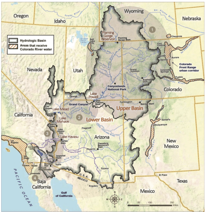
In 1922, the framers of the Colorado River Compact divided the waters of the river, giving the upper basin and the lower basin — California, Nevada and Arizona — 7.5 million acre-feet each. This amount, known as an apportionment or “entitlement,” was thought to be fair at the time because it gave the slow-growing upper basin time to develop their share of the water without the faster-growing lower basin claiming it first.
The mission of the UCRC is to protect the upper basin’s ability to use its share of the river. And this entitlement is symbolic of the upper basin’s dreams and aspirations: growing cities and towns and thriving agricultural communities.
The problem is that the century-old agreement didn’t account for dwindling flows caused by climate change. Studies have found — under what Brad Udall, one of the paper’s authors and a climate and water researcher at Colorado State University, calls “the new abnormal” — that runoff decreases as temperatures rise.
Compounding the issue is that under the compact, the upper basin is still required to deliver the same amount of water to the lower basin regardless of declining flows.
“The reason we entered into a compact was because we knew we couldn’t develop as quickly as the lower basin, so the whole idea is that we could develop later,” said Jennifer Gimbel, former director of the Colorado Water Conservation Board and interim director at the CSU Water Center. “But as we know, streamflow is not as strong and climate change is cutting into it even more and more, and that puts you into a conundrum.”
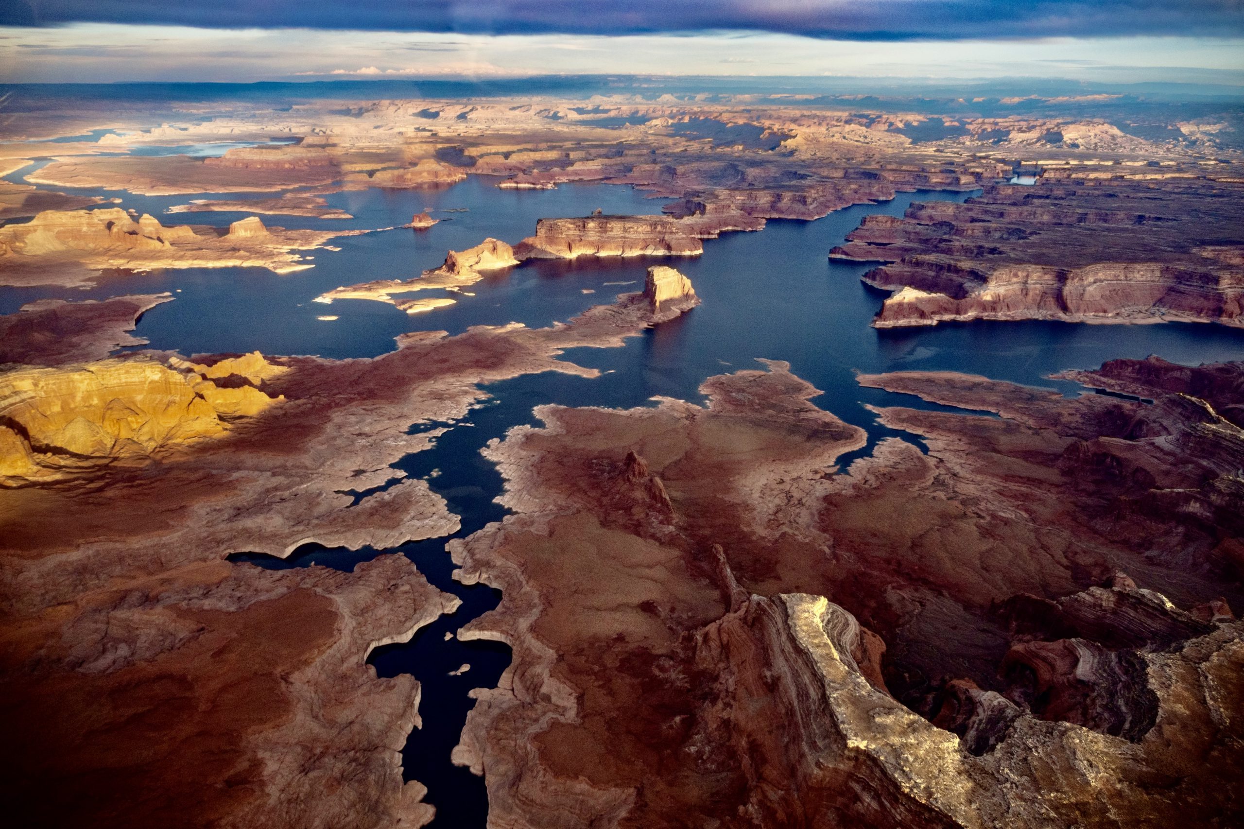
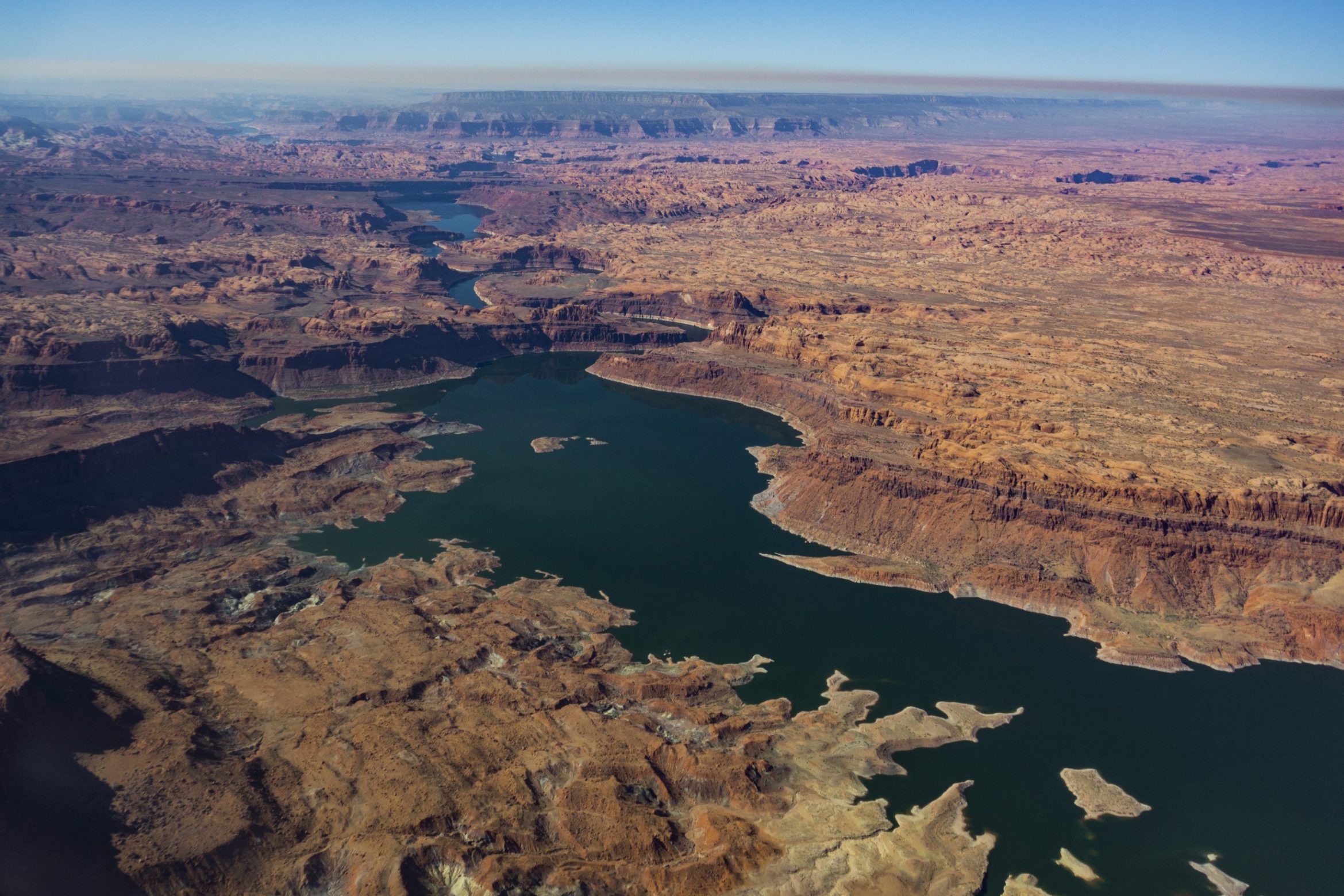
The result is that there are 15 million acre-feet of entitlements on paper, not including Mexico’s share, but just 12 million to 13 million acre-feet of water. And that number is likely to decline even further as temperatures rise. Soon, there may not be enough water for the upper basin to meet its compact obligations to the lower basin and to develop new water projects.
“You cannot have a situation where climate change is reducing the yield of the basin and everyone is sticking to what they think their entitlements are under the compact,” said Eric Kuhn, one of the study’s authors. “Something has to give.”
In other words, if the water physically is not there anymore, it doesn’t really matter what the compact says the upper basin is entitled to.
Kuhn is the former general manager of the Colorado River Water Conservation District and also co-author of the 2019 book “Science Be Dammed: How Ignoring Inconvenient Science Drained the Colorado River.” One of the book’s main points is that past Colorado River decision-makers let politics and competition for a limited supply of water — not science — be the main drivers of river management. Because of that, the river was over-allocated from the beginning. Kuhn worries that this trend may be continuing.
“The fear is that this is another opportunity to ignore the science,” he said. “Forget about these projections that show how much water we might have been able to develop 40 years ago and focus on the river that nature has given us with climate change and not the one we wish we had from decades ago.”
Interstate poker game
The upper basin, including Colorado, is currently exploring the concept of a demand-management program, which could reduce water use by paying irrigators to not irrigate. The goal of the program, which would be temporary and voluntary for participants, would be to send as much as 500,000 acre-feet of water to Lake Powell to prop up levels and avoid a compact call.
A compact call could occur if the upper-basin states can’t deliver the 7.5 million acre-feet of water per year to the lower-basin states as required by the compact. This could trigger an interstate legal quagmire, a scenario that water managers desperately want to avoid.
If it appears contradictory that the upper basin is looking at how to reduce water use while at the same time clinging to a plan for more future water use, that’s because it is.
Water attorney Peter Fleming said some are asking why the upper basin is planning to reduce existing depletions while also planning an additional million acre-feet of depletions. Fleming is general counsel for the River District. He also is on the legal committee for the UCRC, but is not speaking on behalf of that organization here. “It seems the upper basin as a whole needs to reconcile that seeming contradiction,” he said.
Some water experts compared the UCRC’s depletion schedule to an interstate chess or poker game, complete with bluffing. The upper basin must insist it will one day put to beneficial use all of its unused share — or else the lower basin, which already uses all of its own share, could somehow claim the unused portion.
“There’s still this fear that if we don’t use our water, the lower basin will establish an economic use and economic reliance on that water, and it will be very difficult to get it back in the future, even though we are entitled to it,” Kuhn said. “The downside to that right now is the water is just not there.”
Best estimates, not predictions
UCRC Director Amy Haas said in an email that although the paper is thought-provoking, the authors base their analysis on an obsolete projection of future Upper Basin water use demands from 2007 instead of relying on the current 2016 projections, which show a decrease in future demand as well as a slower rate of projected future demand. She said the authors did not consult the commission on the paper before its release.
Study authors have said that current data from the Bureau of Reclamation wasn’t released in time for the 2016 numbers to be used in the paper, and that they used the most up-to-date information available to them. They also say the differences between the two sets of numbers are minor and don’t change their findings.
Haas pointed to the resolution in which the UCRC adopted the 2016 demand schedule, which says demand projections are “best estimates of potential water use based on positive economic conditions and favorable hydrology and climate. As such, they are not predictions of what future water use will necessarily be, but projections for planning purposes to be used for modeling only.”
Colorado’s representative to the UCRC and director of the CWCB Rebecca Mitchell also provided a statement. Colorado is arguably the most important of the upper-basin states when considering these issues because its apportionment of upper basin water is 51.75% and it contributes 70% of the water at Lee Ferry, Arizona, which under the compact is the dividing line between the upper and lower basins.
“Whether we are looking into the concept of demand management or another potential tool for the Colorado River basin states, I remain committed to protecting Colorado’s legally protected entitlements on the Colorado River and our state’s water users,” Mitchell said in an email. “I continue to value input and ideas from a broad range of stakeholders as I work with the other basin states to find lasting solutions to the challenges facing the Colorado River basin.”
Shrinking pizza
An important conclusion of the paper is that water managers will need innovative thinking that challenges the status quo in order to tackle the problems posed by climate change. And there are still many unknowns. For example, could rising temperatures increase water requirements for thirsty crops enough to cancel out water saved from decommissioning power plants? The paper’s authors say that’s an area that needs further study.
But if the upper basin can let go of its plans for more water development, the risks and impacts of future droughts and climate change would be substantially ameliorated, the paper says. In fact, the paper found that even the water use between the years 2000 and 2018, an ongoing period that has been termed the Millenium Drought, would be sustainable and would allow the upper basin to meet its compact obligations to the lower basin — as long as future growth is limited.
In the coming years, water managers will have to grapple with how to allocate slices of an ever-shrinking pizza and science may take a back seat once again.
“People are going to have these really controversial debates about how big a slice you’re going to get when the pie is smaller,” Schmidt said. “All we’re trying to do is inspire those hard-nosed conversations. But at the end of the day, the conversation about how big the slices are is a political negotiation and an economic negotiation; it’s not a science negotiation.”
Aspen Journalism covers water and rivers in collaboration with Swift Communications newspapers. Its water desk is supported by a grant from the Catena Foundation, which also helped partially fund the white paper described in this article. This story ran in the Feb. 25 edition of The Aspen Times and the Glenwood Springs Post-Independent and in the Feb. 28 edition of The Summit Daily.
The Water Desk’s mission is to increase the volume, depth and power of journalism connected to Western water issues. We’re an initiative of the Center for Environmental Journalism at the University of Colorado Boulder. The Water Desk launched in April 2019 with support from the Walton Family Foundation. We maintain a strict editorial firewall between our funders and our journalism.


