
By David O. Williams
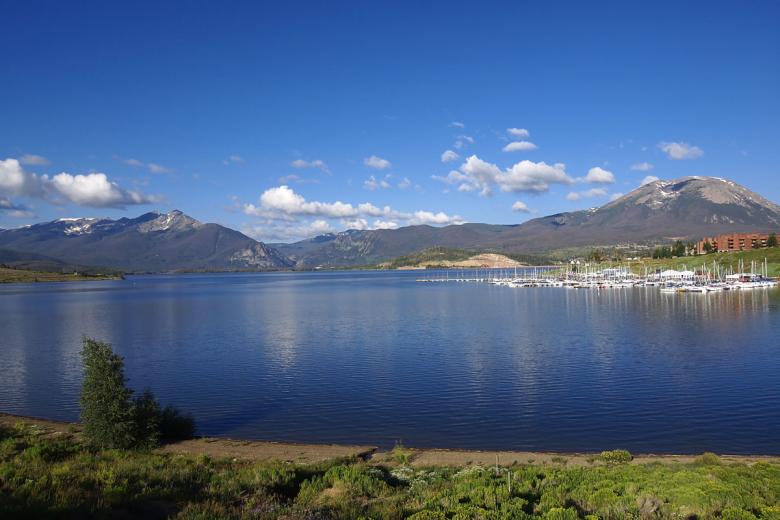
DILLON — Denver Water officials increased the release of water from Dillon Reservoir into the Blue River to about 400 cubic feet per second in the first week of May as inflow held steady at about 500 cfs through Monday, May 11. The latter number is expected to steadily rise as spring runoff picks up.
The current forecast from the National Oceanic and Atmospheric Administration’s Colorado River Basin Forecast Center estimates as of May 11 that there is 146,000 acre-feet of water — in the form of snowmelt — that will flow into Dillon Reservoir through July 31. There’s currently 17,500 acre-feet of space in the reservoir, according to Denver Water, so about 128,500 acre-feet will flow out of the reservoir either to the Blue River or Roberts Tunnel by July 31, with an estimated 13,000 acre-feet through the tunnel.
All of these complex calculations are the first steps in a delicate dance Denver Water performs each spring to balance public safety with Denver’s water needs, recreation, hydroelectric demands and obligations to downstream senior water-rights holders.
“Dillon is our biggest reservoir and one of our more complicated to operate,” said Nathan Elder, water resources manager for Denver Water. “Most of our other reservoirs only have one outlet, but Dillon’s got both the outlet to the Blue and the outlet to the Roberts Tunnel, which provides water to the East Slope and down the North Fork (of the South Platte River) to Strontia Springs Reservoir and then to our customers.”
The Roberts Tunnel, finished in 1962 about the same time the old town of Dillon was relocated to its current spot and the Dillon Dam was built, is a 23-mile concrete conduit that diverts water from the Blue River basin on the Western Slope to the South Platte Basin on the Front Range to supply more than 1.4 million Denver Water customers.
This system is what’s known as a transmountain diversion — one of many that bring water from the Colorado River basin on the west side of the Continental Divide to the state’s population center on the Front Range. What it’s not, Elder said, is a way to avoid dangerous spring-runoff flooding.
“We can’t use Roberts Tunnel as a flood-control option,” he said. “So we’re very careful about the amount of water we take from the West Slope over to the East Slope. And when we use the Roberts Tunnel, we can only take it over to the East Slope if it’s put towards the demand. We can’t just dump it over there to prevent flooding or high flows below Dillon.”
The 2014 Colorado River Cooperative Agreement places a 400,000 acre-foot limit on Blue River water stored in existing or future Denver Water storage facilities on the Front Range.
There are more than 1,000 properties in regulatory floodplains in Summit County, according to the Federal Emergency Management Agency, and quite a few of them are along the Blue as it makes its way northwest through Silverthorne and toward its confluence with the Colorado River near Kremmling.

Snowpack melting
This time of year, as snowpack begins to melt into local tributaries — the Blue, Snake River and Tenmile Creek all feed Dillon Reservoir from the south — Elder and his team closely monitor snowmelt forecasts and weather reports to coordinate with local officials to prevent flooding.
“Denver Water has worked with the town over the years to release water from Dillon Reservoir at rates between 50 cfs and 1,800 cfs,” said Tom Daugherty, Silverthorne’s director of public works. “They have done a very good job of doing that. Denver Water attends our local meetings concerning snowmelt runoff and inform us of what they expect.”
FEMA designates 2,500 cfs as a 10-year flood level just below Dillon Dam, while 3,350 cfs there would be a 100-year flood level. The amount of runoff pouring into the reservoir varies widely, depending on weather conditions and snowpack, from a low inflow of 410 cfs in the drought year of 2012 to a high of 3,408 cfs in 1995.
The amount of snowpack on the Front Range and rate of melting due to high temperatures or rain events also impacts when Denver Water turns on the Roberts Tunnel and how much water it takes out of Dillon Reservoir. The Blue River Decree dictates that Denver Water needs to keep as much water on the Western Slope as possible and can take water only to meet demand.
“Last year was a good example of that,” Denver Water spokesman Todd Hartman said. “We had so much snowpack on the Front Range that we just didn’t need the Roberts Tunnel water and couldn’t take it because of that demand issue.”
That resulted in higher flows on the Blue below the dam last runoff season.
“It got up to around 1,900 cfs, and we didn’t actually turn on the Roberts Tunnel until the second week in August last year,” Elder said. “That’s after everything on the East Slope filled, and we started dipping into that storage and streamflow dropped off on the East Slope.”
This year, there’s a similarly healthy snowpack above the reservoir and also decent snowpack on the Front Range, but temperatures have been higher and the spring runoff season hasn’t been nearly as wet and cool as last year.
“We have a Snotel (snow telemetry) site on top of Hoosier Pass, which is extremely important for monitoring that basin and for forecasting, and it’s still at 121% of normal right now,” Natural Resources Conservation Service hydrologist Karl Wetlaufer said in early May. “It looks like it did actually have a net accumulation through April and is just really just starting to turn around and melt out now over the last few days with this warm weather.”
The Natural Resources Conservation Service produces snowmelt forecasts used by Denver Water, which also taps into the National Oceanic and Atmospheric Administration forecast center.
Based on information from Snotel sites, snowpack above Dillon Reservoir peaked at 127% of normal. The forecast center’s inflow outlook for Dillon Reservoir is 104% of average, and the forecast from the Natural Resources Conservation Service was 107% of average.
The first priority for Denver Water is to fill the reservoir to meet customer needs, but it also tries to minimize high flows out of the reservoir via the Blue River and maintain water levels so that the Frisco and Dillon marinas can operate from June through Labor Day. Elder said the minimum operating level for both Dillon and Frisco marinas is 9,012 feet in elevation.
The goal, Elder said, is to get the reservoir to that level or higher by June 12. On May 11, the surface level of the water in the reservoir was at 9,010 feet. The reservoir is full when the elevation of the water, as measured on the dam, is 9,017 feet, which is 257,304 acre-feet of water. At 9,010 feet, the reservoir is holding about 236,232 acre-feet of water.
Release too much and too early — to avoid high flows and flooding downstream — and Denver Water runs the risk of missing the chance to fill Dillon for use by its customers later in the summer season as well as keep the reservoir full for a long boating season. And then there are the downstream hydroelectric factors and calls by senior water-rights holders.
Senior water rights
While the Blue River Decree does not have a volumetric limit on how much water Denver Water can take out of Dillon Reservoir through the Roberts Tunnel to meet its customer needs, the Roberts Tunnel right is from 1946 and is junior to Green Mountain Reservoir and Shoshone Power Plant rights, which limit the ability of Denver Water to divert. The Roberts Tunnel right is for 788 cfs, which is not a storage right but instead a direct-flow right.
So if Green Mountain gets toward the end of its fill season and hasn’t filled and Dillon has diverted, then Denver Water owes water to Green Mountain. Green Mountain Reservoir, located on the Blue River in northern Summit County, was created specifically to compensate the Western Slope for diversions to the Front Range as part of the Colorado-Big Thompson Project.
Then on the Colorado River in Glenwood Canyon, well downstream from where the Blue feeds the Colorado at Kremmling, there’s Xcel Energy’s Shoshone Generating Station hydroelectric plant — which has one of the most senior water rights on the main stem of the Colorado River. A 1902 right draws 1,250 cfs of water downstream to meet the plant’s needs. During dry times of the year, such as late summer, the power plant often places a “call” on the river, meaning junior diverters upstream — including Denver Water — must stop diverting so that Shoshone can get its full allocation of water.
Elder said Denver Water wants to fill Dillon Reservoir quickly enough each spring before any potential Shoshone call. If a call came before Dillon was full, Denver Water would have to release water from Williams Fork Reservoir in order to keep water in Dillon Reservoir. However, Williams Fork can hold only 96,000 acre-feet of water.
“We want (both reservoirs) to fill quick enough that we fill both before that Shoshone power plant call comes on and before the senior call comes on the river, but not too quick that we fill before peak runoff where we get in those high-flow situations,” Elder said. “So it’s a real balancing act there. You’re balancing elevations for marinas, downstream water rights, filling the reservoir safely and then also any potential releases you may need to make from Roberts Tunnel.”
Aspen Journalism, a 501(c)(3) nonprofit organization supported by its donors and funders, covers water and rivers in collaboration with the Summit Daily News and other Swift Communications newspapers. This story ran in the May 17 edition of the Summit Daily and the May 18 edition of Aspen Journalism.
This story was supported by The Water Desk using funding from the Walton Family Foundation.
The Water Desk’s mission is to increase the volume, depth and power of journalism connected to Western water issues. We’re an initiative of the Center for Environmental Journalism at the University of Colorado Boulder. The Water Desk launched in April 2019 with support from the Walton Family Foundation. We maintain a strict editorial firewall between our funders and our journalism.


