An initiative of the Center for Environmental Journalism at the University of Colorado Boulder

Home Blog Page 46

Video: The vanishing vaquita

Water Desk Grantee Publication

This story was supported by the Water Desk’s grants program.

Learn more about our grants for journalists

Read more grantee stories »

The United Nations says that a million species across the planet are at risk of going extinct, including one-third of the world’s marine mammals. The vaquita, a small porpoise that lives in our backyard in the salty waters of the Upper Gulf of California, is poised to lead the way. Its total population is currently estimated at 12. We take you to San Felipe, Mexico and onto the waters of the Upper Gulf to see firsthand the efforts being made to save this creature and explore why, despite years of warnings about its fate, the vaquita population continues to decline.

Producer/Editor: Vanessa Barchfield

Shooter/Editor: Nate Huffman

This story was supported by a grant from The Water Desk, an independent journalism initiative based at the University of Colorado Boulder’s Center for Environmental Journalism.

See the complete multimedia feature story on Arizona Public Media’s website.

Meet the veteran insider who’s shepherding Gov. Newsom’s plan to bring climate resilience to California water

WESTERN WATER Q&A: Former journalist Nancy Vogel explains how the draft California Water Resilience Portfolio came together and why it’s expected to guide future state decisions

Nancy Vogel, director of the Governor’s Water Portfolio Program, highlights key points in the draft Water Resilience Portfolio last month for the Water Education Foundation's 2020 Water Leaders class.
Nancy Vogel, director of the Governor’s Water Portfolio Program, highlights key points in the draft Water Resilience Portfolio last month for the Water Education Foundation’s 2020 Water Leaders class. (Source: Water Education Foundation)

By Gary Pitzer

Shortly after taking office in 2019, Gov. Gavin Newsom called on state agencies to deliver a Water Resilience Portfolio to meet California’s urgent challenges — unsafe drinking water, flood and drought risks from a changing climate, severely depleted groundwater aquifers and native fish populations threatened with extinction.

Within days, he appointed Nancy Vogel, a former journalist and veteran water communicator, as director of the Governor’s Water Portfolio Program to help shepherd the monumental task of compiling all the information necessary for the portfolio. The three state agencies tasked with preparing the document delivered the draft Water Resilience Portfolio Jan. 3. The document, which Vogel said will help guide policy and investment decisions related to water resilience, is nearing the end of its comment period, which goes through Friday, Feb. 7.

In an interview with Western Water, Vogel acknowledged that every governor seeks to put their stamp on solving the state’s water resource issues. The hope with the Water Resilience Portfolio, she said, is that it can be a catalyst for progress because California’s next drought or flood is never far away and the time to act is now.

Western Water: How would you describe the purpose of the portfolio?

NANCY VOGEL: It’s a high-level policy planning document, much like the Water Action Plan was for the Brown administration. It sets forth our priorities and it’s the blueprint for state agencies working on water. I’ve been impressed with just how much time and energy people have put into providing us input and making sure that it’s on the scale we need.

WW: You have been presenting the portfolio around the state. What’s the response been?

VOGEL: Its generally positive. People say they feel as if they’ve been heard. A lot of people say ‘I can see my comments reflected in the Portfolio, but I’m going to send you another set of comments because I have a quibble with this or that or you forgot X, Y or Z,’ and that’s a good opportunity for us to take another look.

WW: The Sierra Club wrote that the document ‘suffers from an unprioritized list of actions and is ultimately a restatement of water policy depending heavily on a few large-scale and outdated water fixes.’ How do you respond to that?

VOGEL: We’ll have to agree to disagree on that. I do not think the draft portfolio depends on a few big projects. Our approach is diversified, as a portfolio should be. As for the criticism that this is a restatement, we have momentum coming out of the 2012-2016 drought and we want to continue to make progress without massive new mandates on local water districts or attempts at drastic reforms that would unleash uncertainty and stall progress.

WW: What’s the relevance of the portfolio to the average Californian?

Nancy Vogel, a former journalist, is director of the Governor’s Water Portfolio Program.
Nancy Vogel, a former journalist, is director of the Governor’s Water Portfolio Program. (Source: Water Education Foundation)

VOGEL: We all need water and food and want our grandkids to experience spring-run chinook salmon and snow geese. Nobody wants a California where fellow residents lose their homes to flood or tap water to drought. It takes a lot of planning and investment to maintain water supplies and natural systems in a state with such big geographic and timing imbalances in its water resources. This is a document that tries to steer state resources and efforts toward helping the very diverse regions of California be ready for more extreme conditions — drought and flood — and to be able to supply water to communities, the economy and the environment into the future despite climate change and increasing population.

WW: How does the portfolio address the land use changes that are anticipated to occur as a result of the Sustainable Groundwater Management Act?

VOGEL: The draft portfolio acknowledges that local planners face changes in their tax rolls, workforce and land uses, and the state can help local governments anticipate and adjust to those changes with funding and resources for planning. Land uses will change in some places, and that’s going to have a ripple effect on communities and county budgets.

Nancy Vogel
Age: 52
Education: Bachelor of Science, Conservation and Resource Studies, University of California, Berkeley. Master of Arts, University of California, Berkeley Graduate School of Journalism.
Previous jobs: Director of communications at the Resources Legacy Fund, from July 2017 to May 2019. Deputy secretary for communications at the California Natural Resources Agency from 2015 to 2017. Assistant director for public affairs at the Department of Water Resources from 2012 to 2015. Principal consultant for the California State Senate Office of Oversight and Outcomes from 2008 to 2012. Staff writer for the Los Angeles Times from 2000 to 2008 and The Sacramento Bee from 1991 to 2000, where water was part of her assignment.
Fun Fact: One of Vogel’s favorite places is the Knight Foundry in Sutter Creek in the Sierra foothills, a water-powered foundry that was a Gold Rush cradle of innovation – and is still operating, thanks to dedicated volunteers.

WW: The portfolio says a new emphasis on cooperation across state agencies and with regional groups and leaders is needed. How does that occur?

VOGEL: Our approach to the draft Portfolio embodies cooperation — we asked for extensive input. We wanted to hear about local concerns and what water managers think the state can best do to support them as they address those concerns. I think it’s a mindset. Sometimes people forget how much [Integrated Regional Water Management] has accomplished in terms of the way we look at collaboration on a watershed scale. And it’s easy to focus on the things that IRWM isn’t doing or isn’t doing as well as we’d like. But we’re in a much different place now in 2020 than we were in 2000 because of IRWM and we want to build on that. There are lots of other ways for regions to collaborate on a watershed scale and we’re open to that and we want to support that too. But we don’t want to take everything that’s been accomplished and all those human relationships forged in the planning efforts under IRWM — we don’t want to just toss that aside and start over. We want to build on that. And we need to improve the way we coordinate at the state level, too.

WW: How do you make sure this just doesn’t end up another book on a shelf and that there is follow through?

VOGEL: That will take sustained, high-level focus from Secretaries [Wade] Crowfoot, [Jared] Blumenfeld and [Karen] Ross [from Natural Resources, Cal EPA and Food and Agriculture, respectively] and I know they’re committed to that. We also task ourselves with doing an annual update on progress, in which the public will hold us accountable for what we’ve accomplished and have yet to accomplish. We get the resources, the right people in the right places, and we make progress.

WW: How did your experience in journalism prepare you for this task and to be an advocate for this portfolio?

Vogel answers questions from members of the Water Leaders class.
Vogel answers questions from members of the Water Leaders class. (Source: Water Education Foundation)

VOGEL: A journalist learns to listen and to absorb information quickly and to organize it. We had a lot of information coming in quickly as we began to prepare the portfolio and I think my experience with organizing information in a way that I could then disseminate to people who needed to make decisions helped. Journalists get to interview everybody who cares about an issue and so they end up with a unique perspective on a problem that’s valuable. And I felt like I got to do that in some ways as the person who was herding cats on the portfolio. I got to hear everybody’s concerns and that was a privilege. It’s hard to do justice to all the experience and knowledge and often conflicting but heartfelt values reflected in the input we got. We did our best. It was a team effort across the departments and the agencies. It’s been a lot of hours but so worthwhile. I just want to improve the document now and make it the best it can be.

Reach Gary Pitzer: gpitzer@watereducation.org, Twitter: @gary_wef Know someone else who wants to stay connected with water in the West? Encourage them to sign up for Western Water, and follow us on Facebook and Twitter.

This story originally appeared on Western Water on Feb. 6, 2020.

Is renewable energy’s future dammed?

A proposed hydroelectric project on the Little Colorado River shows the tricky trade-offs in transitioning from fossil fuels.

The Little Colorado River in Northern Arizona. Photo by Adobe Stock.

By Nick Bowlin, High Country News

Just outside Grand Canyon National Park in Arizona, a year-round, mineral-rich spring turns the Little Colorado River a vivid turquoise. This final stretch, about 10 miles from the river’s confluence with its larger relative, is one of the West’s spectacular waterways, with bright water flowing below steep red-rock cliffs. But the view will change dramatically if a Phoenix-based company builds a proposed hydropower project. The two dams could alter the flow, discolor the water and flood a Hopi cultural site.

The project remains a long shot: It needs the approval of the Navajo Nation, whose leaders have been publicly skeptical. It also has to contend with varying river flows and the protected humpback chub, plus a remote location that will require building extensive transmission lines. The river’s beauty makes this particular project stand out, but it’s just one of a number of proposed hydropower projects around the West. 

California duck curve graphic

The structure of today’s energy market helps explain hydropower’s appeal, even for dubious projects like this one. As it stands, renewables struggle to match power supply to common patterns of demand (as revealed by solar energy’s “duck curve”). The result is a renewable energy bottleneck. If the U.S. is to meet global climate goals, an enormous, rapid shift away from fossil fuels is needed. This creates what one recent academic paper calls “green vs. green trade-offs,” exemplified in the West by the recent trend of proposed hydropower dams. Such projects destroy waterways and harm ecosystems — but they could also help purge the grid of fossil fuels.

Solar power works only during the day, and wind is inconsistent. To meet peak power demand, which tends to spike at night, utilities rely on coal, nuclear and — increasingly — natural gas. In order to rapidly increase and decrease supply to meet real-time demand, gas plants must run all the time. This limits the amount of solar and wind power the grid can accommodate, thereby prolonging fossil fuel use. States are already producing more solar and wind power than their grids can take. 

The capacity to store the day’s excess solar and wind power for nightly use would solve the problem. Battery storage, while advancing fast, is years away from being both advanced enough to replace gas plants and fully integrated into power production, according to Suzanne Stradling, a University of New Mexico Ph.D. student who is studying the renewable transition. If we could meet peak power without natural gas, she said, “there’s no limit to the amount of solar we could bring onto the grid.”

But how do you manage without gas power? Coal is a greater pollutant, and nuclear waste is politically — as well as environmentally — toxic. That leaves hydropower. Like gas, hydropower can ramp up power generation almost instantly. Pumped storage dams, which are essentially enormous batteries, could meet peak power demand, allowing solar and wind energy to chase gas and coal from the grid. Fourteen of the 15 dams proposed in the West this year are designed for pumped storage, according to federal data. But many face obstacles similar to those confronting the Little Colorado project. 

Some proposed Western dams would use existing infrastructure, not natural systems like the Little Colorado River. There is a move to transform an abandoned iron mine outside Joshua Tree National Park into a massive hydropower plant, for example, while Los Angeles wants to convert Hoover Dam into a pumped storage facility. But by the time new projects are permitted and built, “things in the energy industry are going to look entirely different,” Stradling said. This uncertainty can make it hard to attract investors. And in another region-wide trend, several multi-state transmission projects — the kind that will bring Wyoming’s excess wind power to other states — are already underway. Recent expansions to California’s energy imbalance market are another important step toward a true regional market. A more unified grid, combined with better battery storage, will reduce the need for hydropower projects.

Meanwhile, other hydropower projects are coming online. A $1 billion pumped storage dam will begin construction in Montana next year, and another hydropower project has been approved in California’s San Diego County. Both are near transmission lines and will help decarbonize Western grids.

But what sort of future are we committing ourselves to by building these dams? This question occupies University of Wyoming professor Tara Righetti. The infrastructure we build now, she said, will lock us into certain futures, while denying others. The enduring difficulty of accounting for 20th century infrastructure is apparent in behemoths like Glen Canyon Dam and the push for dam removal on the Snake River in southeastern Washington. Even after battery technology improves and the power grid supplies Nevada with Wyoming wind on a cloudy day, hydro storage dams will still exist. For there is a cost to not building them — our continued reliance on existing energy infrastructure and natural gas plants to keep the lights turned on.

“All power sources have an impact,” she said. “If there’s a human imperative to address climate change, that means finding the right spot to make these trade-offs.”

Nick Bowlin is an editorial fellow at High Country News. Email him at nickbowlin@hcn.org or submit a letter to the editor

This story was originally published at High Country News on Nov. 1, 2019.

The Water Desk’s mission is to increase the volume, depth and power of journalism connected to Western water issues. We’re an initiative of the Center for Environmental Journalism at the University of Colorado Boulder. The Water Desk launched in April 2019 with support from the Walton Family Foundation. We maintain a strict editorial firewall between our funders and our journalism. The Water Desk is seeking additional funding to build and sustain the initiative. Click here to donate.

Who should pay for water conservation in the West? Water managers wade into discussion

Seen from the air, Glen Canyon Dam holds back the Colorado River to form Lake Powell. The state of Colorado is looking into how to fund a program that would pay irrigators to reduce their consumptive use in order to send water downstream to a savings account in Lake Powell. Courtesy Photo.

By Heather Sackett

LAS VEGAS — Water managers from throughout the Colorado River Basin took the stage at the Colorado River Water Users Association conference earlier this month to talk about conserving water in the face of the twin threats to the river: increasing demand and climate change.

The state of Colorado is currently exploring a water-use-reduction program that is largely designed to pay farmers and ranchers on the Western Slope to voluntarily conserve water. While there’s still debate whether such a program should be implemented, the first question many ask is how to pay for such a program. In recent months, some water managers have come up with innovative ways to fund the controversial water-use-reduction plan — known as demand management — that wouldn’t rely entirely on taxpayers.

The drought contingency plan, which water leaders inked at last year’s annual CRWUA meeting, set up a reserve account of 500,000 acre-feet of water that the Upper Basin — Colorado, Wyoming, Utah and New Mexico — could use to store water in Lake Powell as an insurance policy against dwindling reservoir levels.

In November, Colorado voters passed Proposition DD, which is projected to funnel roughly $16 million a year to the Colorado Water Conservation Board, or CWCB, by taxing sports betting. Demand management is one of the two things money from Proposition DD could fund (the other is Water Plan grants).

However, it’s widely accepted that $16 million is not enough to fund either of those things in their entirety. Demand management needs other sources of money.

Although the Glenwood Springs-based Colorado River Water Conservation District still isn’t convinced that a demand-management program is the right approach for the Western Slope, general manager Andy Mueller told the Las Vegas crowd that the Upper Basin has to reduce its water consumption — and explore creative solutions to accomplish that.

“I often talk about the Lower Basin overuse and how that’s driving the problem, and I will say they in the Lower Basin need to fix that problem,” Mueller said. “I will also say we in the Upper Basin … need to reduce our use. The science is pretty clear. Water we all thought was there even 15 years ago is not going be there. You can’t have water for the environment and the people if we are not reducing consumptive use throughout the basin.”

General Manager of the Colorado River Water Conservation District Andy Mueller speaks at the district’s annual seminar in 2018. Mueller told the audience the Upper Basin needs to reduce its consumptive use at the Colorado River Water Users Association conference in Las Vegas earlier this month. Photo by Brent Gardner-Smith/Aspen Journalism.

Who should pay?

So, if nearly all water users on the Colorado River, including those in the Lower Basin — California, Nevada and Arizona — would stand to benefit from a demand-management program, who should pay for it?

Not Colorado taxpayers, Mueller said, at least not entirely.

“Eighty million (dollars) a year would need to be out there in payments to get the appropriate amount of water in Lake Powell,” he said. “That cost to taxpayers is too high. So you turn to: Who else benefits from us creating a storage account in Lake Powell?”

One answer: power providers in both the Upper and Lower Basin states, who all need Lake Powell to remain above 3,525 feet, the minimum level required to continue generating hydropower.

For example, the Western Area Power Administration sells hydropower generated at Glen Canyon Dam and other federal dams along the Colorado River to local communities, including Aspen and Glenwood Springs. In all, WAPA sells hydropower from the Colorado River system to about 200 customers, including municipalities, rural electric cooperatives, federal and state agencies, irrigation districts and Native American tribes.

Mueller thinks adding a small demand-management surcharge to customers’ bills is something that should be explored,

“Power customers should share in the costs of us storing for demand management,” he said.

Another potential source of funds could be nonprofit environmental groups, since sending more water downstream to Lake Powell would also benefit stream health. The federal government, whose Bureau of Reclamation operates Lake Powell and Lake Mead, also has a role to play, Mueller said.

But no matter where the money comes from, Mueller said it must be channeled through the CWCB in a heavily regulated market to prevent speculation by private buyers.

“We have been very clear it needs to be a guided market if it’s going to happen, with lots of thoughtful, proactive rules to prevent lots of serious consequences,” he said.

This field in lower Woody Creek is irrigated with water that eventually flows into the Colorado River. The state of Colorado is exploring how to fund a program that would pay irrigators to reduce their consumptive use in order to send water downstream to a savings account in Lake Powell. Photo by Brent Gardner-Smith/Aspen Journalism.

State-led exploration

The CWCB currently has a workgroup devoted to exploring how to fund demand management. The group has met twice so far, but CWCB facilitator Anna Mauss said the two biggest questions the group is grappling with are these: how much water is needed and what would the cost be. The workgroup, she said, will dive deeper into funding strategies at the next meeting, scheduled for the end of January.

“We are baby-stepping into this, trying to be diligent,” Mauss said. “It’s really just looking at scenarios at this point.”

The state is also encouraging innovative ideas from the private sector. The CWCB recently awarded $72,000 to 10.10.10, a Colorado Nonprofit Development Center project that aims to tackle “wicked problems” in water and climate. Under the program, 10 entrepreneurs will, over 10 days, attempt to tackle 10 systemic issues that are not adequately addressed by government, organizations or institutions.

“Yes, we are looking at demand management, and it could be one of the wicked problems we address,” said Jeffrey Nathanson, president of 10.10.10.

Water from the Colorado River irrigates farmland in the Grand Valley. The state of Colorado is looking into how to fund a program that would pay irrigators to reduce their consumptive use in order to send water downstream to a savings account in Lake Powell. Photo by Brent Gardner-Smith/Aspen Journalism.

Platform for payment?

While some people work on finding sources of funding, others are already creating a platform to pay irrigators once the money is in place. Southwest Colorado water managers Steven Ruddell and David Stiller think a reverse auction to compensate water users for using less is the best way to go.

A reverse auction, which features many sellers (farmers and ranchers) and one buyer (the state of Colorado through the CWCB), would allow water-rights holders to set the lowest price they are willing to accept to voluntarily send their water downstream. According to Ruddell and Stiller’s paper on the subject, a reverse auction would remove paying for demand management from a political process and move it into a market-based process that lets water-rights holders bid the fair-market value of their water. It would also keep costs down for the CWCB.

Ruddell and Stiller presented their reverse-auction idea at the Upper Colorado River Basin Forum at Colorado Mesa University last month.

“We’ve tried to bite off a small piece of demand management by suggesting we use an auction that people are familiar with,” Ruddell said. “It’s used to determine the value of something, especially in the ag world.”

There are still many questions surrounding how a demand-management program might be paid for.

“There are all sorts of options,” Mueller said. “We shouldn’t just focus on raising taxes in our state.”

This story originally appeared on Aspen Journalism on Jan. 30, 2019.

Aspen Journalism collaborates with The Aspen Times and other Swift Communications newspapers on coverage of water and rivers. This story appeared in the Dec. 30, 2019 edition of The Aspen Times.

The Water Desk’s mission is to increase the volume, depth and power of journalism connected to Western water issues. We’re an initiative of the Center for Environmental Journalism at the University of Colorado Boulder. The Water Desk launched in April 2019 with support from the Walton Family Foundation. We maintain a strict editorial firewall between our funders and our journalism. The Water Desk is seeking additional funding to build and sustain the initiative. Click here to donate.

State looking to oppose White River storage project in water court

The view looking downstream at the proposed site for the reservoir and dam on the White River. Colorado's top water engineers are looking to oppose the project in water court because of their concerns that it is speculative. Photo by Heather Sackett/Aspen Journalism.
The view looking downstream at the proposed site for the reservoir and dam on the White River. Colorado’s top water engineers are looking to oppose the project in water court because of their concerns that it is speculative. Photo by Heather Sackett/Aspen Journalism.

By Heather Sackett

Craig, Colorado — After years of their questions and concerns not being met, Colorado’s top water engineers are looking to formally oppose the water rights associated with a proposed reservoir project in northwest Colorado.

In November, the Colorado Division of Water Resources filed a motion to intervene in the Rio Blanco Water Conservancy District’s application for a 90,000-acre-foot conditional water-storage right on the White River. The state DWR is now waiting for a judge to determine whether it will be allowed to file a statement of opposition in the case.

For more than 4½ years, state engineers have expressed concerns that the conservancy district has not proven there is a need for the water, which would be stored in the proposed White River reservoir and dam project between Rangely and Meeker. The issue is whether Rio Blanco has shown that it can and will put to beneficial use the water rights it applied for in 2014. It remains unclear whether the town of Rangely needs the water.

“And throughout this case, the Engineers have consistently maintained that RBWCD must demonstrate that its claimed water right is not speculative,” the motion reads. “Although RBWCD has addressed some of the Engineers’ concerns in the past six months, the Engineers maintain that RBWCD has not met its burden.”

State Engineer Kevin Rein said his office had been trying to resolve its concerns with Rio Blanco’s claims to water informally and doesn’t take filing a motion to intervene lightly.

“We are very aware of the influence we can have on the process and costs and delays, so we don’t just frivolously file a statement of opposition every time we have some issue with a case,” Rein said. “We believe there are issues that need to be fixed in this water-court application in order for it to go forward.”

One option for the White River storage project would be an off-channel dam and reservoir at this location. Water would have to be pumped from the White River into the reservoir site. Photo by Heather Sackett/Aspen Journalism.

Rio Blanco declines comment

The White River storage project, also known as the Wolf Creek project, would store anywhere from 44,000 to 2.92 million acre-feet of water. The water would be stored either in a reservoir formed by a dam across the main stem of the White River — this scale of project proposal is now rare in Colorado — or in an off-channel reservoir at the bottom of Wolf Creek gulch, just north of the river. Water would have to be pumped from the river uphill and into the off-channel reservoir.

Rio Blanco District Manager Alden Vanden Brink declined to comment on the state’s opposition, citing concerns about litigation. Vanden Brink also is chair of the Yampa/White/Green River Basin Roundtable and sits on the board of the Colorado River Water Conservation District.

Rio Blanco is a taxpayer-supported special district that was formed in 1992 to operate and maintain Taylor Draw Dam, which creates Kenney Reservoir, just east of Rangely. The district extends roughly from the Yellow Creek confluence with the White River to the Utah state line.

Rio Blanco says Kenney Reservoir is silting in at a rate of 300 acre-feet per year, threatening the future of Rangely’s water supply and flatwater recreation, and a new off-channel reservoir on the White River could help solve this problem.

Deirdre Macnab, seen here on her 13,000-acre 4M Ranch between Rangely and Meeker, is the current sole opposer in the water court case for the White River storage project. Colorado’s top water engineers are looking to intervene in the case because they say the project applicant has not proven there is a need for the water. Photo by Heather Sackett/Aspen Journalism.

Opposition

If a water-court judge grants the motion to intervene, the state will become the second opposer in the case. Currently, the only other remaining opposer is 4M Ranch, owned by Deirdre Macnab.

Tucked between rolling hills of arid, sagebrush-covered rangeland, the proposed reservoir and dam site abut her 13,000-acre property along the White River.

Macnab, who bought the beef and hay operation nearly five years ago, is on the board of the conservation group White River Alliance, as well as the Yampa/White/Green River Basin Roundtable. Macnab said the main reason she opposes the reservoir project is because of the state’s concerns.

“If we felt that there was a clear purpose and need that would benefit the public, then we would, in fact, be supportive of this,” Macnab said. “But the fact that the experts are saying there does not appear to be a clear purpose and need means that this would be a real travesty and waste of taxpayer money. It’s something we will continue to oppose until that changes.”

A view of the White River foreground, and the Wolf Creek gulch, across the river. The Rio Blanco Water Conservancy District has been using state funds, and their own, to study two dam options for this area between Meeker and Rangely on the White River. Photo by Brent Gardner-Smith/Aspen Journalism.

Additional concerns

State engineers are also concerned about the vagueness of the revised amounts of water for various uses that Rio Blanco says it needs.

In a 2018 report, Division 6 engineer Erin Light questioned Rio Blanco’s claims that it needed water for industrial/oil and natural gas/oil shale and irrigation uses. In response, Rio Blanco dropped those claims but almost doubled the need for municipal and industrial use for the town of Rangely and added a new demand for recreation.

The conservancy district also set the amount of water for environmental needs for threatened and endangered species at between 3,000 and 42,000 acre-feet despite its acknowledgement that the actual amount needed for this use was unknown. Rio Blanco then added a new demand for a sediment pool of 3,000 to 24,000 acre-feet and an insurance pool of up to 3,000 acre-feet but did not describe either of these uses.

“Thus, despite removing its claims for industrial/oil and natural gas/oil shale, which originally accounted for over half the demand for the claimed water right, the total demands for water identified by RBWCD actually increased to 24,000-100,000 acre-feet,” the motion to intervene reads.

Grant money

Since 2013, the Colorado Water Conservation Board has given roughly $850,000 in grant money to Rio Blanco to study the White River storage project, including a $350,000 Colorado Water Plan grant in 2018. According to CWCB communications director Sara Leonard, Rio Blanco has so far spent about 60% of these most recent grant funds.

Leonard said that DWR’s motion to intervene was not a surprise to the CWCB, that the two state agencies with seemingly differing views on the project have met and that the CWCB is aware of the state engineers’ concerns.

“The grants that have been awarded to the applicant to date have all been with the intention of helping the District with the evaluation process,” Leonard wrote in an email. “In other words, the motion has not changed the scope of the ongoing work in the grant.”

The Colorado River Water Conservation District has also given Rio Blanco $50,000 toward investigating the feasibility of the storage project.

“We are not advocates and we are not opposers,” said Jim Pokrandt, director of River District community affairs and chair of the Colorado River Basin Roundtable. “It’s a regional question that our constituents need to figure out.”

This story originally appeared on Aspen Journalism on Jan. 20, 2020.

Aspen Journalism collaborates with The Craig Daily Press and other Swift Communications newspapers on coverage of water and rivers. This story appeared in the Jan. 17, 2020 edition of The Craig Daily Press.

The Water Desk’s mission is to increase the volume, depth and power of journalism connected to Western water issues. We’re an initiative of the Center for Environmental Journalism at the University of Colorado Boulder. The Water Desk launched in April 2019 with support from the Walton Family Foundation. We maintain a strict editorial firewall between our funders and our journalism. The Water Desk is seeking additional funding to build and sustain the initiative. Click here to donate.

Degrees of warming: Rising temperatures, shorter winters and a declining snowpack are impacting Aspen’s snow-dependent culture

A snowcat sits on grass just days before Snowmass Ski Area opened this winter. As temperatures warm, ski resorts could face shorter seasons, less snowpack and more challenges making artificial snow. This year, it snowed heavily just before SkiCo opened Aspen Mountain and Snowmass the weekend before Thanksgiving. Photo by Elizabeth Stewart-Severy/Aspen Journalism

By Catherine Lutz 

ASPEN — Approaching Labor Day weekend of 1961, many Aspenites who had plans to go camping or enjoy outdoor concerts watched in trepidation as monsoon rains didn’t let up for two days. Then, that Friday night, the damp chill turned rain to snow — large, wet snowflakes fell overnight and for the next two days, thoroughly coating the green, late-summer landscape. Tree limbs bent and snapped, the music tent started to rip under the weight of the snow, motorists were stranded when Independence Pass closed and the power went out in the city for two days. 

“It was a hell of a mess,” said lifelong Aspenite Jim Markalunas. 

The mayor called Markalunas and asked him to reboot the defunct hydroelectric plant he had previously run while the regional electric utility struggled to restore the downed lines.  

He managed to restore power to Aspen, and by the time residents woke up to a cold, sunny Labor Day morning, 27 inches of snow had fallen in town, a record that still stands, according to Markalunas, author of “An Aspen Weather Guide” and “Aspen Memories.” 

Now 89, Markalunas also has tales of being surrounded by massive snowbanks as a 6-year-old in the 1930s and worrying about roofs collapsing from the heavy-snow years of the 1980s. 

 “Big snow years are oh-be-joyful for the (Aspen Skiing Company) and skiers but made for a lot of hard work for people maintaining the streets and intakes and such,” he recalled.

Aspen Ski Corp president D.R.C. Brown stands in front of a nearly bare Little Nell ski run during the dismal ski season of 1976-’77. After this season, SkiCo invested in snowmaking technology to make up for what Mother Nature doesn’t always deliver. Photo by Aspen Historical Society, Cassatt Collection

Markalunas remembers lean years, too, most notably the winter of 1976-77. That ski season didn’t start until January and recorded just 86 inches of snow all winter. It also spurred massive investments in technologies to battle drought impacts, such as snowmaking and cloud-seeding.

 Markalunas likes to say that Aspen’s weather is “consistently inconsistent.” But he started noticing a difference in patterns in the 1980s — in particular, less-frequent below-zero temperatures. 

“The trend is we just don’t have the super-cold weather we used to have,” he said, pointing to weather data he has compiled from water department records showing that Aspen has hit a low of less than minus 20 just once since 1997.

“It seems as though the weather pendulum swings more extremely than in years of old,” Markalunas writes in “An Aspen Weather Guide.” “Storms are more violent but less frequent. The weather appears to be more volatile than in past years. … Unless we act to decrease carbon dioxide emissions, ski racks on SUVs might become useless accessories here.”

Markalunas’ observations are supported by other data, analyses and studies that paint a picture of a changing local climate. Pitkin County is warming, the number of frost-free days is increasing and snowpack is declining — all of which have myriad impacts on recreation, the ecosystem, wildlife, streamflow, water availability, droughts and wildfires. One of the most notable impacts is on the underpinning of modern Aspen’s economy: snow and skiing.

Officials at Aspen Skiing Company, or SkiCo, have been aware of changing temperatures and snowfall for some time. Like others, the biggest change that Rich Burkley, SkiCo’s senior vice president of strategy and business development, has seen in his 30-year career is more variability.

 “It’s a feast of riches or famine, and you have to deal with that,” he said.

The start of this ski season has been a feast, with above average snowpack across the state.

It’s getting warmer

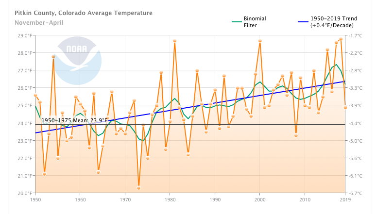
Pitkin County’s average temperature has been rising at a rate of 0.4 degrees per decade since 1950, according to the National Oceanic and Atmospheric Administration. In 2018, the average temperature throughout the year in Pitkin County was 39.5 degrees — 2.9 degrees warmer than the mean temperature during the baseline period of 1950-75.

Pitkin County’s average temperature each year since 1950 has risen, at a rate of .4 degrees Fahrenheit per decade, compared to the mean (gray line) temperature during the 1950-1975 baseline period. The Climate at a Glance tool, from NOAA’s National Centers for Environmental Information, can be used to plot historical temperature or precipitation data in a time series from a global to a city level. Graphic by NOAA.

Pitkin County’s average temperature each year since 1950 has risen, at a rate of .4 degrees Fahrenheit per decade, compared to the mean (gray line) temperature during the 1950-1975 baseline period. The Climate at a Glance tool, from NOAA’s National Centers for Environmental Information, can be used to plot historical temperature or precipitation data in a time series from a global to a city level.

More-dramatic changes are happening in the cold-season months. Temperatures are rising almost half a degree per decade between November and April, compared with about one-quarter of a degree the other half of the year.

March is by far the fastest-warming month, heating up at a rate of 1 degree per decade since the 1950s. The average temperature of 34.4 degrees in March 2017, when Aspen hosted the World Cup ski racing finals, was a record 9.4 degrees higher than the 1950-75 baseline temperature. 

The race venue on the lower half of the mountain lost several inches of snow surface per day, Burkley said. The only reason there was enough snow to race on was extra early-season snowmaking that at the time was considered excessive.

Markalunas’ theory of fewer really cold days shows in this data as well. Average annual low temperatures have risen in Pitkin County and appear to be accelerating — average minimum temperatures were more than 5 degrees higher than the baseline during three of the past five winters.

Low temperatures in the winter months in Pitkin County are rising faster than average yearly temperature — at a rate of .5 degrees per decade. The average low from November through April was 12.4 degrees from 1950-1975; it reached a record high of 18.1 degrees in the winter of 2016-17. Graphic by NOAA.

Low temperatures in the winter months in Pitkin County are rising faster than average yearly temperature — at a rate of .5 degrees per decade. The average low from November through April was 12.4 degrees from 1950-1975; it reached a record high of 18.1 degrees in the winter of 2016-17.

“Even since 1980, there has been a pretty sharp annual average temperature increase over time,” said Elise Osenga, research and education coordinator for the nonprofit Aspen Global Change Institute, or AGCI. “Even just a couple degrees difference is a notable difference in annual average temperatures — especially if you are a seasonal-sensitive plant or animal.”

2014 report by AGCI notes that rising low temperatures, particularly in early winter, can affect the ability to make snow on the ski mountains, an activity typically limited to November and December. This hasn’t impacted SkiCo much yet, according to Burkley. Snowmaking now is about twice as efficient as it was two decades ago, thanks to automation and improved technology. 

SkiCo also has plans to expand snowmaking to the top of Aspen Mountain next season, which Burkley said will be key to Thanksgiving openings as the upper part of the mountain often doesn’t have enough natural snow in November. 

Zooming out, a recent Washington Post feature found that Pitkin County and much of the Colorado Rockies are warming faster than other places. Pitkin County’s average temperatures have risen 2.34 degrees since 1895, at the height of the Industrial Revolution; the average across the United States is 1.8 degrees. In fact, western Colorado and eastern Utah comprise a large “hot spot” that warns of greater climate shifts to come.

Freezing? Not so much 

 One critical trend related to rising temperatures — in particular, rising low temperatures — is an increase in the number of frost-free days, which AGCI counts as consecutive days of above-freezing temperatures from the last freeze of spring to the first time it dips below 32 degrees after that. Like temperature, the number of frost-free days has risen sharply in recent decades.

Since the 1980s, there’s now an additional month each year without freezing temperatures in Aspen, according to AGCI’s analysis. The actual number of days above freezing varies widely from year to year, but there is a clear upward trajectory, as seen in the Forest Health Index, which is produced by the Aspen Center for Environmental Studies with help from AGCI. 

 “When it’s not freezing, there won’t be snow to accumulate,” said AGCI executive director John Katzenberger. “And those adaptations like making snow will be more important but will be more curtailed by when temperatures are sufficiently cold to make the snow.”

A shorter freezing season could also reduce snowpack if more precipitation comes as rain instead of snow and shorten the end of the ski season if snow melts faster and earlier.

“(Climate change is) impacting us, but so far we’ve been able to adapt,” said Burkley. “There’s a lot of long-term capital planning, though: expanding snowmaking, higher snowmaking, water storage, and possibly adjusting operational times and dates.”

Higher temperatures mean less snow

Changes are, of course, also being felt beyond ski-area boundaries. In the summer of 1994, big-mountain skier Chris Davenport first skied 14,092-foot Snowmass Mountain, named for the massive snowfield that historically stretched across a wide bowl below its summit. 

 “In the next decade or so, it seemed like that permanent summer snow was getting smaller and smaller, until one summer in the mid-2000s, it was totally gone,” said Davenport. “It’s a direct effect of warming — even if it’s a few degrees, that snowfield couldn’t hang on.”

Winter snow might still linger into the summer months on Snowmass, Davenport said, but most years, the formerly year-round snowfield is gone by mid-July.

A skier hikes toward the 12,392-foot summit of Aspen Highlands in December 2017, during a low-snow winter. The ridge leading to Highland Bowl is usually covered with snow, even early in the winter. Photo by Catherine Lutz.

A skier hikes toward the 12,392-foot summit of Aspen Highlands in December 2017, during a low-snow winter. The ridge leading to Highland Bowl is usually covered with snow, even early in the winter.

The waning snowfield on Snowmass Mountain is representative of a larger trend. Summer snow covering the Northern Hemisphere receded from 10.28 million square miles at its peak in 1979 to a low of 3.69 million miles in 2013, according to Climate Central’s website WXshift.com. Not only does that impact water supplies, but less snow cover means more sunlight absorbed by Earth, driving a feedback loop of further temperature increases.

Snowfall has also decreased in many parts of the United States, according to the Environmental Protection Agency, although no significant trends in precipitation have been found in the Aspen area or Colorado in general. Some climate models predict more precipitation in the future, but rising temperatures could mean that precipitation comes more often as rain rather than snow.

 In Pitkin County, as in the American West and other mountain drainages around the world, snowpack is arguably the most consequential climate-change indicator. Mountain snowpack not only determines availability of snow for recreation but also how much water will be available for all manner of natural and human uses. In Colorado, including the Roaring Fork River valley, snowpack —  usually measured by the amount of water in the snow, known as snow water equivalent, or SWE — is generally variable and can range widely from year to year. But this, too, has become more extreme in recent years. 

“We’ve observed these huge year-to-year shifts,” said Karl Wetlaufer, a hydrologist with the U.S. Department of Agriculture Colorado Snow Survey, which collects and manages snowpack data. “So that does feel like a trend: Over the last 15 years, things seem to be much more erratic, with more extreme years on both high and low ends.”

 The scientific community considers the April 1 snowpack the peak of the water year. Only once  since 2010 has the Roaring Fork basin’s snowpack on April 1 been measured between 85% and 115% of normal, said Wetlaufer. That range was more common in earlier periods.

Hydrologist Karl Wetlaufer noted recent large swings in Roaring Fork basin snowpack data from the USDA’s National Water & Climate Center. The past 10 years show higher peaks and valleys than the longer-term record. Courtesy of Karl Wetlaufer

Hydrologist Karl Wetlaufer noted recent large swings in Roaring Fork basin snowpack data from the USDA’s National Water & Climate Center. The past 10 years show higher peaks and valleys than the longer-term record.

The last two winters feature some of the wildest snowpack swings — and the most extreme weather events. From October 2017 to September 2018, snowpack peaked at 72% of normal; the following snow season, it peaked at 144%. 

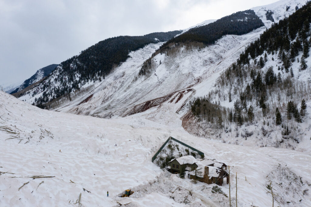
The low-snow season resulted in such tinder-dry conditions that the Lake Christine fire, the most threatening fire in recent valley history, burned for months in the summer of 2018. That was followed by a winter capped off with an unprecedented avalanche cycle, the result of a steady buildup of the snowpack on a weak base layer, ultimately unleashed by a massive storm cycle that was fueled by warm atmospheric rivers from the Pacific Ocean.

Besides more variability, some recent scientific analyses, including this map produced by the EPA and AGCI’s 2014 report, have found that Colorado’s snowpack is decreasing. A study published by Peter Goble and Nolan Doesken of Colorado State University’s Colorado Climate Center found that central Colorado’s snowpack is diminishing by an average of .49 inches of SWE per decade, which was the most of the four regions studied. This calculation includes measurements taken at a station near Independence Pass. 

A half-inch of SWE can equate to 7.5 to 10 inches of snowfall, Goble said, which over 100 years could mean 75 to 100 fewer inches of snow — about one-third of the roughly 300 inches that fall on average on the Aspen Snowmass slopes.

 “Considering that loss may accelerate, those numbers look a little threatening to the local lifestyle,” said Goble.

Recent research also accounts for factors such as dust on snow, likely to be more frequent in the future given the increasing aridity of areas west of Colorado and more human disruption of those areas. Dust on snow, similar to rain on snow, melts the snowpack more quickly.

Scientists agree that the main factor contributing to a declining snowpack is not less snowfall but warmer temperatures due to increased greenhouse-gas emissions. And because temperatures are expected to continue to rise — the amount depends on how much emissions are curbed — snowpack around Aspen and elsewhere will continue to decline.

Still, Goble is hopeful.

 “When you look at the projections and how winters might change, it’s not a totally hopeless situation,” he said. “We still have control over our future. If this is a problem humans take seriously and we see a lot of action on a large scale over the next couple decades, it will make the outlook for the back half of the century a lot brighter than if it was business as usual.” 

AGCI’s 2006 report for the city of Aspen, on the other hand, painted a dire scenario for future skiers (as well as downstream water users) with continued warming, including the potential for shorter ski seasons and substantially reduced snow cover.

Aspen Mountain will still be skiable in 2030 under all emissions scenarios, the report concluded, but “by 2100 the base area of Aspen Mountain has essentially lost a skiable snowpack, with the exception of the lowest greenhouse-gas concentrations.”

In all future emissions scenarios, the AGCI report found that Aspen Mountain’s base snowpack will start to accumulate later in the fall and melt earlier in the spring due to warming temperatures. Snow depths at all elevations are projected to be reduced throughout the season. In the worst-case scenario, the ski season will be 10 weeks shorter by 2100 and “snow depth goes to near zero for the entire lower two-thirds of the mountain.” That’s everything below the base of the Ajax Express chair.

 “Under these scenarios, some of our seasons are shortened and our terrain could be reduced,” Burkley said. “We would be in download situations more frequently. We would build and concentrate snowmaking at higher elevations. We might have more hike-to or hike-out terrain.  We would build lifts to access areas that have more consistent snowpack.”

Burkley said with existing infrastructure, SkiCo can offer lift-served, high-elevation skiing on three mountains. The proposed 180-acre Pandora expansion on top of Aspen Mountain also would expand into terrain that “will probably have the best snow in the future.”

A machine blows artificial snow at the top of Little Nell on Aspen Mountain in Dec. 2017. SkiCo is building out snowmaking infrastructure as one way to adapt to a changing climate, but that, too, relies on sufficient water in local streams and cold enough temperatures. Photo by Elizabeth Stewart-Severy / Aspen Journalism

A machine blows artificial snow at the top of Little Nell on Aspen Mountain in Dec. 2017. SkiCo is building out snowmaking infrastructure as one way to adapt to a changing climate, but that, too, relies on sufficient water in local streams and cold enough temperatures.

Even as SkiCo relies more on snowmaking, Burkley acknowledges minimum streamflow requirements could be an additional challenge. There could be a time when natural snowpack declines to the point that there won’t be enough water in local streams to make all the snow it needs, in which case the company might have to decide to shut down one or more of its four mountains and focus efforts on what remains open.

SkiCo is also increasing its focus on summer operations, including Snowmass Bike Park. For now, this helps ensure a return on expensive infrastructure; later, it could help make up for shorter winters.

Ironically, the Aspen Snowmass ski areas could actually benefit in the short term from climate change. They’re situated at higher elevations with colder temperatures than many other resorts, especially those outside of Colorado, and could see increased visitation as lower-elevation ski areas become less viable.

Clearly, Aspen isn’t the only ski resort facing an existential crisis. Ski areas across the country are recognizing the challenges that climate change poses to their viability, and that’s provoking a shift in industry thinking.

“In recent memory, climate was an uncomfortable conversation. Resorts said it was politicized science,” said big-mountain skier Davenport, who is now a climate activist and board member of the advocacy group Protect Our Winters, or POW. “Now everyone’s on board.” 

The scale of action is bigger than resorts switching to renewable energy or lobbying for climate-friendly policies in Washington, D.C., as SkiCo has been doing for years. Three of the largest industry groups — Outdoor Industry Association, Snowsports Industries America and National Ski Areas Association — recently formed the Outdoor Business Climate Partnership to provide leadership and inspire action on climate change. Using POW’s playbook, SIA launched United by Winter, a climate-advocacy platform for its members. And POW is now on the radar of elected officials in every state where the outdoor industry has a presence.

“It used to be inconvenient for outdoor companies to talk about climate change, but now the opposite is true: If you’re not having that conversation, consumers aren’t buying from you,” Davenport said. “Look how we’ve changed the conversation.”     

This story was originally published by Aspen Journalism on December 18, 2019.

Editor’s note: Aspen Journalism is collaborating with Aspen Public Radio on coverage of environmental issues. A conversation about this story aired on Dec. 19.

The Water Desk’s mission is to increase the volume, depth and power of journalism connected to Western water issues. We’re an initiative of the Center for Environmental Journalism at the University of Colorado Boulder. The Water Desk launched in April 2019 with support from the Walton Family Foundation. We maintain a strict editorial firewall between our funders and our journalism. The Water Desk is seeking additional funding to build and sustain the initiative. Click here to donate.
As 2020 kicks in, historic Colorado River Drought Plan will get its first test

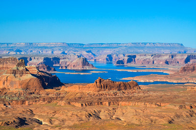
Lake Powell, created with the 1963 completion of Glen Canyon Dam, is the upper basin's largest reservoir on the Colorado River. But 2000-2019 has provided the least amount of inflow into the reservoir, making it the lowest 20-year period since the dam was built, as evidenced by the "bathtub ring" and dry land edging the reservoir, which was underwater in the past. As of October 1, 2019, Powell was 55 percent full. Photo credit: EcoFlight
Lake Powell, created with the 1963 completion of Glen Canyon Dam, is the upper basin’s largest reservoir on the Colorado River. But 2000-2019 has provided the least amount of inflow into the reservoir, making it the lowest 20-year period since the dam was built, as evidenced by the “bathtub ring” and dry land edging the reservoir, which was underwater in the past. As of October 1, 2019, Powell was 55 percent full. Photo credit: EcoFlight

By Laura Paskus

This year, the first-ever Colorado River Drought Contingency Plan is set to launch, and water officials expect 2020 to bring unprecedented changes to the way the river is run, including cutbacks in water use by some states.

Drought and climate change are expected to play a leading role in determining how to reduce water use and bring the stressed river system into a sustainable, balanced state of being.

After historically low levels were reached last year in Lakes Powell and Mead, Arizona and Nevada are now poised to implement their first-ever cuts in water diversions, while Colorado and the other upper basin states are working to explore ways to conserve water and bank it in Lake Powell’s new drought pool to avoid future shortages.

Brad Udall, a senior climate scientist at Colorado State University’s water center, said the river’s operations are set for a major rework.

2019, he said, was “a really big [water] year, so I think everybody’s happy, but to think somehow the drought is over and climate change isn’t happening—or to hope for the best and ignore the lessons of the last 19 years—I think these high temperatures will remind people, ‘This is not the same old game we used to play in the 20th century.’”

A look back

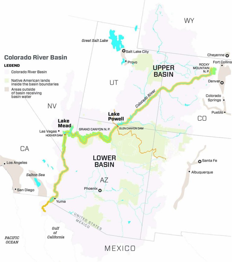
A lot has changed since the Colorado River Compact first divvied up the river’s waters in 1922. Today, more than 40 million people in two countries rely upon the river, which originates on the Western Slope of the Rocky Mountains in northern Colorado, and is fed by major tributaries like the Green, Gunnison and San Juan rivers. Cities from Denver to San Diego, though geographically outside of the natural river basin, divert water from the river for drinking and industry, and farmers irrigate 5.5 million acres of everything from alfalfa to melons.

The Colorado River Basin is also now more than 2 degrees Fahrenheit warmer than the twentieth century average—with “hotter” droughts depleting river flows. By necessity, as the climate continues to change, bringing continued warming and drying, shortage-sharing agreements on the river must continuously be updated to keep changing, too. The Drought Contingency Plan (DCP) was needed as a stop-gap until a new set of operating guidelines, due by 2026, are written.

The DCP’s predecessor

The DCP’s origins lie with the Colorado River Interim Guidelines. Written in 2007, the operating guidelines were designed to address the Colorado River’s deteriorating storage levels. They identify how to operate the river’s two major reservoirs, Lake Powell and Lake Mead, under hotter, drier conditions, and to share the risk of shrinking water supplies between the upper and lower basins.

But the 2007 interim guidelines, while temporarily keeping the basin out of crisis, did not anticipate the extent of drought that the basin would experience. In 2013, then-Secretary of the Interior Sally Jewell directed states to consider additional measures or face unilateral federal action to avoid a potential crisis. With its own interests to protect, including water deliveries to contractors and tribal water rights, the federal government needed states to put a more robust plan in place.

That led to the latest temporary plan, the DCP, which negotiators say provides some security in avoiding a potential crash of the Colorado River system.

Six years in the making, the DCP includes two plans, hammered out separately by the lower and upper basin states. The upper basin plan focuses on flexibility in reservoir operations during drought conditions, investigating how to reduce water demands—including with voluntary water conservation programs—and weather modification to augment precipitation. In the lower basin, the process needed to move more quickly because water use already exceeds allocations. Cities and farms in Arizona, California and Nevada agreed to scale back and take deeper cuts as Lake Mead reaches threshold elevations that trigger those cutbacks. This summer, the first threshold was triggered, so Arizona and Nevada will implement their cutbacks this year.

Developing plans for each basin was tricky considering that within each state there are also individual tribes, competing interests, and conflicts between urban and rural water users. But, pushed by a deadline from U.S. Bureau of Reclamation Commissioner Brenda Burman, in March 2019, the seven states asked Congress to provide necessary authorizations to execute their final plans. In an era when Congress spends much of its time at an impasse, legislators on both sides of the aisle recognized the need for drought planning. In April, federal legislators passed the Colorado River Drought Contingency Plan Authorization Act and the following month, on May 20, representatives from the seven basin states and Department of the Interior signed completed upper and lower basin drought contingency plans.

Colorado River Basin: Credit: Chas Chamberlin

Not a new problem

As Eric Kuhn and John Fleck write in their new book, “Science Be Dammed: How Ignoring Inconvenient Science Drained the Colorado River,” even during compact negotiations in the 1920s, records showed the river’s annual flows were lower than the total 17.5 million acre-feet allocated to the seven states and Mexico. In fact, three different studies during the 1920s estimated natural river flows at Lee Ferry at between 14.3 million acre-feet and 16.1 million acre-feet.

Planners chose to ignore that information, Fleck says, and with it, they ignored convincing evidence showing the basin regularly experienced long periods of drought. “We have rules written down on paper, allocating water across the basin, that essentially allocate more water than the river actually has—and this manifests itself quite differently in the lower basin than the upper basin,” says Fleck, director of the Water Resources Program at the University of New Mexico. Fleck’s co-author Kuhn is the now-retired general manager of the Colorado River Water Conservation District.

In the lower basin, California, Nevada and Arizona have long overused their share of the river (approximately 7.5 million acre-feet annually, averaged over 10-year rolling cycles), Fleck says, whereas the upper basin states have yet to use more than around 4 million acre-feet (of the “remaining” 7.5 million acre-feet originally intended, but not necessarily guaranteed, for them). But everyone needs to come to terms with the fact that there is less water in the basin, Fleck says. “And that’s what the DCP is,” he says. “The first steps toward a long-term plan for everyone to use less water.”

Today, Kuhn and Fleck note, the river’s average flow between 2000 and 2018 has been only 12.4 million acre-feet—16 percent lower than the 1906-2017 average of 14.8 million acre-feet per year.

To use less water, the two basins need their own strategies. In the lower basin, the DCP sets rules to scale back use of lower basin allocations as Lake Mead drops, or until storage conditions improve. Arizona, Nevada and Mexico will see cuts this year, while California could follow in future years if reservoir storage declines continue. Over the past few years, water users already started scaling back voluntarily, and, says Fleck, “The DCP gives the structure that gives us the confidence [the cutbacks] will continue,” he says.

The upper basin occupies a precarious position of its own, even though it uses less water than it technically could under the compacts that govern its use—use in the upper basin has remained flat, at around 4 million acre-feet per year, since 1990. Because upper basin states must not interfere with a specific quantity of water flowing downstream, they’ll take on much of the burden of dealing with declining flows in a warmer future, Fleck adds. “That means the upper basin has to be sure it has the tools in place to make sure it can continue to meet its compact obligations, to send water out of Lake Powell,” he says. “And it may have to figure out how to conserve water below 4 million acre-feet.”

Challenges of a warming world

Any planning on the Colorado River—from the crops farmers plant, to the ways in which cities incentivize conservation among customers, to the DCP’s successor—must address the fact that the basin is facing a hotter, drier future.

Rainfall records, reconstructed from tree ring chronologies that stretch back more than a thousand years, reveal past patterns of southwestern droughts, marked by dry conditions associated with natural climate variability. Today’s droughts in the basin are different. They are notable not just for a lack of precipitation, but also for warmer temperatures, which spur changes in snowpack, increase transpiration in forests and fields, and boost evaporation from reservoirs.

The U.S. Global Change Program’s Fourth National Climate Assessment in 2018 painted a troublesome picture of reduced water supplies and future food insecurity in the region. It also identified risks to southwestern tribes from drought and wildfire, and challenges to the region’s infrastructure and energy supplies.

More localized studies of the Colorado River Basin also show that as climate change continues to heat and dry the region, the river’s flows will keep dropping. A 2017 study by Brad Udall, a senior water and climate research scientist at the Colorado Water Institute at Colorado State University and Jonathan Overpeck, dean of the School for Environment and Sustainability at the University of Michigan, showed that flows between 2000 and 2014 averaged 19 percent below the 1906-1999 average, with one-third of those losses due to higher temperatures, versus changes in precipitation. If warming continues, according to that 2017 study, Colorado River flows could decline by 20 to 35 percent by 2050 and 30 to 55 percent by the end of the century.

A study published the following year by Udall and others reiterated that “unprecedented basin-wide warming” was responsible for the declines, this time looking at 1916 through 2014, when the river’s flows dropped by 16.5 percent during that period, even though annual precipitation had increased slightly. The study also revealed the entire basin’s sensitivity to shifts in precipitation patterns—that it matters whether precipitation comes as rain or snow, and also where it falls. Snowfall in the upper basin is more beneficial to the system, for example, than rainfall in southern Arizona. And the future doesn’t look promising: The 2018 study forecasts a future decline in snowfall within four sub-basins in Colorado.

Healthier snowpack this past winter offered everyone a bit of a reprieve, but the Colorado River Basin’s problems aren’t over. At the end of the water year, total system storage was at only 53 percent, according to Reclamation, though that’s up from just under 47 percent in October 2018.

An earlier version of this article appeared in the Fall 2019 issue of Headwaters magazine. This story was published by Fresh Water News on January 8, 2020.

Fresh Water News is an independent, non-partisan news initiative of Water Education Colorado. WEco is funded by multiple donors. Our editorial policy and donor list can be viewed at wateredco.org.

Aspen’s rich history of befouling the Roaring Fork River

An Aspen couple, circa 1900, in front of their dirt-chinked cabin with a sod roof and opaque windows. The man holds what may be a miner’s dinner pail behind his back and the woman’s dress shows the stains of hard work. Behind the house is a barn and outhouse. East Aspen Mountain, home of today's Ute Trail, is visible, which suggests the cabin was in the Eames Addition, near the top of South Aspen Street. Photo credit: AHS, Masterson Estate Collection.
An Aspen couple, circa 1900, in front of their dirt-chinked cabin with a sod roof and opaque windows. The man holds what may be a miner’s dinner pail behind his back and the woman’s dress shows the stains of hard work. Behind the house is a barn and outhouse. East Aspen Mountain, home of today’s Ute Trail, is visible, which suggests the cabin was in the Eames Addition, near the top of South Aspen Street. Photo credit: AHS, Masterson Estate Collection.

By Tim Cooney

On the afternoon of Aug. 23, 1895, Frank Klangel felt the urge and went out to the privy behind his uncle’s saloon, Adam’s Place, on Cooper Avenue between Hunter and Galena in downtown Aspen. As the angled sun over West Aspen Mountain (today’s Shadow Mountain) streamed through the open door into the usually dark place, Klangel looked down into the vault hole to commence business. There he saw a man’s feet clad in heavy shoes sticking up out of the muck.

Saloon owner Adam Klangel, jailer Hudner, police Capt. Williamson and coroner Hughes “inaugurated measures to get the man’s body out of the fearful receptacle,” the Aspen Times reported the next day. “All his body was buried except the pedal appendages.”

With the building overturned, the coroner climbed down the wood cribbing of the vault and secured a rope around the dead man’s feet. A number of men assisted in raising the corpse, which was so covered as to be unidentifiable.

They spent an hour hosing him — laid out in the street — and cutting off his clothes before the coroner could examine the body. Word spread and a crowd gathered “to witness one of the most despicable sights ever brought to mortal vision,” one that “tested the endurance of the strongest constitutions,” the Times said.

In the crowd was a member of the deceased’s family, who at a certain point identified the body of Irishman Dominik Crosson, a pumpman for the Schiller Mine on Aspen Mountain (off today’s Schiller Road ski trail). Crosson had left his home on Juan Street for work at 7 a.m. the day before, but “later in the forenoon was seen among the Cooper Avenue resorts.”

Coroner Hughes noted bruises on Crosson’s face, but no wounds indicated foul play. Hughes concluded that an inebriated Crosson stumbled on the upright board that served as a seat and fell into the “sufficiently large aperture where he entered the death trap.” The coroner surmised he had been upside down in the viscous night soil for the past 24 hours.

A young man tending to business in Aspen, 1900. The view is of West Aspen Mountain, now Shadow Mountain, possibly from the pond on the flats of the one-time Paepcke Ranch, or some former pond above today’s William’s Addition, above Centennial. Photo credit: Aspen Historical Society

Vault mining

Make no mistake that the good-old days in earliest Aspen were better than now. The Times editorialized on March 22, 1890, that Aspenites “were careless to the preservation of their own health,” due to the estimated 2,500 privy vaults and cesspools in the city proper that had been accumulating filth since 1880.

On the heels of silver mining prosperity, early townspeople simply threw dirt on top of a full vault and dug another. Newspapers reported open cesspools under wooden sidewalks around town. Accumulation, seepage and odors had to be addressed because they affected health and clean drinking water.

Add to that the spring rains and snowmelt that churned an unimaginable mud season, where town commerce and mule-drawn delivery became a challenge. The March 27, 1893, edition of the Aspen Daily Chronicle warned, “West Main Street is not navigable for mud scows drawing over four feet of water.”

Between 1879 and through the early 1900s in the mining camp, polluting was a de facto industrial right. Everything from mining waste, sewage, slaughter offal, city dump runoff and sawdust drained into the Roaring Fork River. With cholera outbreaks around the world and medicine finally connecting the circular route of disease from sewage to table, Aspen doctors warned of the need to avoid a city pestilence.

Although mortality in Aspen due to dysentery and idiopathic fevers was often mentioned in the newspapers, and with local cemeteries evidencing many young deaths, one clip in the Times noted that the “little son of Mr. and Mrs. Bert Watts nearly died of cholera infantum.”

In 1890, the Times reported that Aspen officials had directed W.J. Connors — who was the “city scavenger,” an official position since the mid-1880s charged with cleaning and disinfecting alleys with lime and hauling animal carcasses, slop, night soil and more to the city dumping grounds — to clean out the old vaults, at $15 to $240 per vault. City scavengers quit often, but the higher-paying job came with city-backed “enforcement and emoluments.”

The vault-cleaning “work is done in the silence of night all winter long,” and once opened, “for a three block radius it is impossible to breathe. … The labor is severe and the men use strong disinfectants and take extra care of their health in the vitiated atmosphere,” the Times wrote. Connors’ crew, utilizing horse teams, dug out 450 vaults that winter, some as deep as 40 feet.

West Aspen in 1896. The City Sawmill was at the west end of Cooper Avenue across Castle Creek from the Holden Lixiviation Plant. Just on the edge of the ravine served by the train loop is the Aspen Smelting Company/Texas Smelter structure near the Castle Creek bridge. Waste from all three went into the Castle Creek before the Roaring Fork River junction. Red Butte is in the background. Photo credit: AHS, Shaw Collection

Lazy dumpers

Before 1889, the city dumping grounds were in the Riverside Addition, the Times noted on April 28, 1888, a poorer neighborhood just over today’s Roaring Fork River bridge toward the North Star Nature Preserve, where many Irish and English miners lived and a lot cost $50. There the city regularly took bids to burn animal carcasses.

On March 30, 1889, the Rocky Mountain Sun (RMS) wrote that the city dump had relocated to a 10-acre parcel overlooking Maroon Creek (near today’s Aspen High football field), where it remained until the 1960s. The newspapers between 1890 and as late as 1917 cited noxious accumulations and lazy dumpers tossing carcasses and putrid refuse along the road to the dump. Accounts said festive trips to Maroon Bells were a gauntlet-like challenge and the air in the town’s West End sported the odor.

In Glenwood Springs (originally called Fort Defiance), where the Roaring Fork T-boned the Grand River, the Times reported on Oct. 5, 1888, that the mayor and the entire board of trustees were arrested for telling their town scavenger Mike Tierney to dump offal into the Grand, in violation of a state statute concerning pollution of a running stream.

In 1897, the July 3 edition of the RMS headlined a story “Fishing vs Mining,” wherein state game warden Swan served notice to Aspen’s Smuggler Concentrator to “cease putting tailings into the Roaring Fork and so into the Grand,” that the “mine water is poisonous and destroying the fish.”

The newspaper countered that the opaque water “preserved trout from the persistent whipping by town anglers,” that Swan’s attempts are “a piece of bumbledom” and “the biggest and gamest trout is not worth the contents of a workingman’s dinner pail.” The paper argued he would close down Aspen mines, put thousands out of work and bankrupt shareholders. “With mines, it is impossible to stop putting runoff in streams. Swan must be taught this and his officiousness curbed.”

This view of Aspen, in 1910, overlooks the Roaring Fork River and the Smuggler Concentrator plant, which processed zinc and lead. Its toxic tailings, along with untreated sewage from town, drained into the river. Note the two cabins between the concentrator and the river, each with an outhouse on the river. Just upriver from the mill, the Galena Street sewer outlet, across from “Oklahoma Flats,” drains into the river. Photo credit: John Bowman via AHS, Shaw Collection

River bears it away

In fact, Aspen was an industrial Victorian city with the unhygienic conditions of Dickensian London. During the camp’s mining boom between the mid-1880s and early 1890s, the population of between 12,000 and 14,000 peaked in 1893.

As has been the case since civilization, rivers have served as disposals; however, the Roaring Fork had an extra advantage in settlement days, before later water diversion, when it unleashed a good month-long torrent during spring runoff that scrubbed mining and foul sediment out of the deeper riverine pools. This flushed everything downstream to Glenwood and beyond.

But this hard-working act of nature was diminished when Eastern Slope water diversion in the early 1930s fractioned the Roaring Fork’s runoff. Accounts say the Roaring Fork got its name before diversion because the daily roar was so loud around town that people had to yell.

These days, the norm is mostly a quiet meandering, and the observant might notice during the low-water season of August that the once-natural-colored rocks along the Rio Grande Trail on down are permanently stained black from past ore-processing waste.

In 1900, a pistol-packing woman, second from left, holds a lever-action rifle (possibly a legendary Henry rifle) while standing with a group of sawyers and another woman of the era. They are holding peaveys, or ‘cant dogs,’ which were used to roll logs. Sawdust from the many local sawmills often went into the streams and river, disrupting the trout population. Photo credit: John Bowman via AHS, Shaw Collection.

Primary sources

These observations and more — found in the Aspen Historical Society’s archives in a 1976 firsthand, written account by Bede Harris, who was born in Aspen in 1884 — say that mine dross stained the river a lead color from the Neale Street Bridge (today’s No Problem Bridge) down, leaving a blue, black and brown hue on the rocks and sand bars, even past Basalt.

Difficult Creek and upper Roaring Fork rocks were also stained by early 1880s runoff from upstream gold mining in the town of Independence, on Independence Pass. An RMS article titled “Our Drinking Water,” published Oct. 9, 1886, described concentrate from two wood-fueled stamp mills there as discoloring the “almost perfect translucent (water) to a yellow ochre, with the consistency of new made cheese,” lacing it with “undetectable quicksilver” (mercury) from the stamp plates.

Before that mix reached Aspen, the story said, the water cleared itself. Yet Andy McFarlane’s early 1880s sawmill, just east of town, and timber work in McFarlane Gulch, above today’s Difficult Campground (see “Hope delivers Pandora’s Box,” aspenjournalism.org), added sawdust to the water. Other sawmills populated Castle, Maroon and Hunter creeks. The sawyer’s trick then was to run a canal under the saw blade that zigzagged back to the creek.

A detailed 1896 map of town by W.C. Willits, on file at the historical society, shows the lineup of Aspen industry draining waste into the Roaring Fork then: the Aspen Sampling works near today’s Gant condos; the Smuggler Concentrator (which Harris called the “lead mill”), near where the Eagles Club now stands; the Mellor Foundry in today’s Mill Street Plaza area; and Sander’s Brewery in the Pitkin Green locale. The RMS reported in 1885 that Aspen consumed 120 kegs of beer per day in winter and 160 in summer.

On Castle Creek, just above its intersection with the Roaring Fork in today’s Holden/Marolt grounds, the massive Holden Lixiviation Plant, the Union Smelting Company and the Aspen Smelting Company (a.k.a. Texas Smelter) sent their discard downriver as well.

This became worse, Harris wrote, after 1900 and through 1917 when mining-populist David Hyman massively dewatered and reopened the deeper levels of the Smuggler, Free Silver, and Mollie Gibson in hopes of a mining renaissance after the economic crash of 1893. (See “Dewatering Smuggler Mountain mines,” aspenjournalism.org.)

Harris mourned the loss of in-town trout fishing during Hyman’s mining revival and, after water diversion, the disappearance of water-skipper bugs, pollywogs, frogs, muskrats and the delightful water ouzel songbird that dips its head as it sings and dives under the current for larvae, before resurfacing and resuming its same tune. Gone too, he wrote, were the many toads about town that came out after summer cloudbursts.

As we know now, it all connects. But in Aspen’s short history in the scheme of things, how the early settlers first managed the abundant clean water from the mountains deserves a closer look.

Aspen, circa 1887. The Ute Spring area is on the edge of town at the base of the mountain, at left. On the right side, the facial profile of the original, reclining “Aspen Silver Queen” can be seen in the ridge contour of West Aspen Mountain (Shadow Mountain). The profile then was also known as the “Sleeping Ute” on what some called Ute Mountain. Photo credit: Aspen Historical Society

Ute Avenue vanguard

When a handful of prospectors and Aspen pioneers first came over “Hunter Pass” (Independence) from Leadville in 1879, they dipped their tin cups into creeks without a thought of pollution or giardia. They camped by the clear, pooling waters of “Ute Spring,” which a rudimentary 1881 Aspen map at the Aspen Historical Society places between the soon-to-come Argentum Juniata and lower Durant mines, where today’s lower Aspen Alps abuts Aspen Mountain Road.

That map shows the Ute Spring streaming down a pastoral Original Street to Hunter Street, across today’s Rio Grande field and into the Roaring Fork near the John Denver Sanctuary. This runnel was Aspen’s first water supply.

Accordingly, original settlers built their cabins with access to the Ute Spring along Ute Avenue, the first official “street” in Aspen, an Aspen Times column on Feb. 21, 1886, recounted. Others erected tent dwellings and businesses along the spring’s flow down to the Roaring Fork.

As town boomed with silver strikes on Aspen and Smuggler mountains in the 1880s, water-supply routes for irrigation and general use became a priority for the camp.

Setting the stage prior to that, the robust B. Clark Wheeler (not to be confused with Jerome B. Wheeler of Opera House and Jerome Hotel fame) snowshoed over Independence Pass during the first winter of 1879-80 and resurveyed the nascent town of “Ute City,” which had already been laid out by the first wave of “’79-er pioneers.” After many had decamped for the first winter because of the rumor of a possible Ute Indian invasion, Wheeler registered his new plat in Leadville and renamed the town Aspen.

Some resented Wheeler, believing he had “claim-jumped” the town from the first settlers. On top of that, he declared ownership-by-discovery of the Ute Spring and set to managing it, reinforcing the ever-filling pool and installing spouts to fill barrels.

Then Wheeler claimed the rudimentary west-flowing “town ditch” first cut from the spring along the bottom of Aspen Mountain, which supplied water near Mill Street and Durant Avenue, where the Clarendon, Aspen’s first hotel, opened in 1881. Personal ditches connected to the town ditch, too. The first settlers down Ute Avenue had already built an east-flowing ditch from the spring to service them.

That same year, Wheeler started the Aspen Times, the first newspaper in town, which reported on April 23 that kids played in the ditches and dammed them, causing flooding, and reported on May 6 that the town trustees approved an ordinance: “No dead animals or brute or foul or nauseous substance” could be disposed of in the water ditches.

Of course, water flowing through uncovered ditches free to horses, burros, loose pigs and jacks became turbid. In 1882, a follow-up ordinance cracked down on sawdust disposal in the ditches and, later, in the Roaring Fork. Remarkably, some still took drinking water from the ditches.

A detail of an 1881 map shows a portion of the route of the flow from Ute Spring, crossing Spring Street toward Original. The spring was at the foot of Aspen Mountain, about where today’s Aspen Alps office stands.Photo credit: Aspen Historical Society
A detail of an 1881 map shows a portion of the route of the flow from Ute Spring, crossing Spring Street toward Original. The spring was at the foot of Aspen Mountain, about where today’s Aspen Alps office stands. Photo credit: Aspen Historical Society

Water monopoly

Initially, Wheeler let water flow gratis through the town ditch and original Ute runoff. But with his improvements, he aimed to profit. Entrepreneurial “watermen” brokered the clean Ute Spring water about town from him, delivering “table water” in barrels on carts, dubbed “Donkey Hydrants” by the Times.

One waterman said he would “rather trade with 10 men than one woman,” because women bargained too well. The waterman added: “Her weakness is her weapon.” Another said it “cost the Christian Church $4.50 every time a batch of sinners is baptized.”

Soon, controversy brewed, because many believed that nobody owned the spring water. A letter in the Times on Aug. 30, 1881, said “the great Ute Spring in its quiet beauty pouring forth its crystal flood … was put there by the great creator for all to use.”

Afraid that the town’s water supply might become unaffordable if Wheeler monopolized, Mayor Tanfield and a public interest of townspeople incorporated the Aspen Irrigation and Ditch Company (AIDC), the May 5, 1882, edition of the Times reported. They dug the first ditch from the Roaring Fork at the end of “Waters Avenue,” connecting with the original town ditch along the bottom of Aspen Mountain, which then commingled with the Ute Spring water Wheeler claimed as his.

That AIDC ditch snaked from Waters Avenue onto Ute Avenue — the original course of which the 1896 Willits map infers. The previously cited newspaper accounts indicate that the “Wheeler Ditch” trail along the Roaring Fork just northeast of today’s Ute Avenue is a misnomer and should actually be named the AIDC Ditch.

Stock in the town’s AIDC cost $5 per share. A day’s work digging equaled one share. This defrayed the delivery cost of $1.50 per month to town lots for those who worked, while water came free to lots planted with trees. The AIDC expanded ditches throughout town, while many dug their own channels off these to their dwellings or businesses.

The crew at the Aspen Times stands in front of the newspaper’s offices, then on Cooper Ave, in 1890. Photo credit: Aspen Historical Society

Wheeler schemes

In reaction to the formation of the citizens’ ditch company, Wheeler cooked up a Victorian leveraged-buyout scam. The May 7, 1882, edition of the RMS reported that he speciously offered the new AIDC board use of “his ditch” (the original town ditch along the bottom of Aspen Mountain) and the natural Ute Spring runoff ditch to the Roaring Fork in exchange for consideration.

He valued his labor and infrastructure at a bloated $75,000, offering that as stock value in a new company to be under his control. But the AIDC rejected his offer and trenched that first ditch from the Roaring Fork at the end of Waters Avenue, which connected via flume over Wheeler’s Ute Spring waterworks with the old town ditch he still claimed as his property.

Next, the City Council stepped in and granted right of way to the new AIDC ditch water, nullifying Wheeler’s claim to the town ditch, the May 20, 1882, edition of the Times reported. With that, Wheeler showed his true colors.

His own paper — the Times — proclaimed on Sept. 9, 1882, “Troubled Waters” and “Attempted subversion of the existing order of things relative to the Ute Spring by B. Clark Wheeler … the water rustler.”

A flume carrying water discharge, and possibly mining discharge, flows into the Roaring Fork River, just above and east of the Neale Street Bridge (No Problem Bridge) in Aspen in 1910. On the right, a large-diameter pipe heads toward the river, too. The Ute Spring area is at the base of the mountain in the background. Photo credit: AHS, Masterson Estate Collection.

Aspen women take charge

Enraged, Wheeler tore out the AIDC’s bypassing water flume over his Ute Spring operation to the town ditch. He then rerouted “his Ute Spring water” solely into the town ditch, disrupting the AIDC flow and posting a notice threatening legal prosecution if anyone interfered, while announcing he would build a locked shed over the Ute Spring. Personal threats against him and plans to burn that building became shrill.

When finally confronted at the spring, the Times said, Wheeler threatened further court action to prove his ownership of the spring, surrounding property and water rights. With that, a contingent of town women took charge and surrounded Wheeler. The Times quoted one as saying, “If the men couldn’t manage him, the women could.” Wheeler backed down, but his reputation for being a tricky dealer continued.

In reaction to the uprising, Wheeler formed the rival Aspen Ice and Water Company in 1882. The RMS reported on May 5, 1885, that there were two ditch companies competing, the AIDC and Wheeler’s. At some point after, AIDC quit using the disputed upper town ditch, prone to overflowing into structures below, and built a lower ditch down Durant from their Waters Avenue river tap.

With water flowing unobstructed into gardens and stock pens, table water delivery resurfaced as an issue. The RMS reported on August 15, 1885, that someone dynamited waterman “Swede Jacob Brown’s” water tank because he was selling water at 25 cents per barrel, while other water-cart owners fixed prices at three barrels for $1. Weeks before, someone put coal oil in Brown’s tank and removed two “burrs holding a wheel” on his cart.

Donkey-cart deliveries from the prized Ute Spring water continued until 1889, when the Sept. 28 edition of the RMS reported the end of Ute Spring as a major water source because mining above had diverted the flow.

Much later, mining magnate David Hyman, for whom Wheeler originally brokered Hyman’s initial 1880s Aspen mining claims, reflected circa 1920 on Wheeler in his autobiography, “Romance of a Mining Venture,” that Wheeler was “a man of wonderful energy, of great professions, but whose character I never admired and whose knowledge of mining matters was not at all equal to his profession.”

This 1900 view of Aspen, from the lower Castle Creek valley, shows DRC Brown’s Aspen Water Company reservoirs, which supplied Aspen with water starting in 1886. One is in the foreground, near the location of today’s city water treatment plant and reservoir, and one is across the creek on the lower western flank of West Aspen Mountain, now Shadow Mountain. Photo credit: Aspen Historical Society

Kidney health

With town growth, the hustle and bustle of more traffic, trash accumulation on lots, the mud-manure, road-base mix of town streets and settling detritus into the ditches, the need for water beyond the murky ditches became an infrastructure necessity and plentiful, alternative water from Castle Creek and Hunter Creek came on line.

To this end, the Aspen Water Company, “organized by esteemed townsmen H.C. Cowenhoven and D.R.C. Brown secured the franchise to supply the city with water,” the Times reported on Jan. 2, 1886. A crew excavated ditches and laid the water mains about town by that March.

That water supply came by flume and ditch out of Castle Creek to a reservoir on the west side of Aspen Mountain just downstream of today’s Music School. A 1900 photo at the AHS locates that oblong reservoir and another on the opposite side of the creek above today’s hospital.

After earlier debate comparing “Hunter’s Creek” (now Hunter Creek) with Castle and Roaring Fork waters, the town physician — to whom the city paid $50 a month, according to the complete town ordinances published in the July 27, 1886, edition of the Times — weighed in favoring the mineral composition of Castle Creek for better kidney health.

This photo shows the lower end of the Castle Creek ditch and flume water-delivery system to Aspen, part of Cowenhoven’s and Brown’s Aspen Water Company, which first piped water into west Aspen around the corner of Shadow Mountain and down West Hopkins Avenue. The photo was taken in 1900 near today’s foot/bike path bridge over Castle Creek to the Holden/Marolt Mining and Ranching Museum. Photo credit: AHS, Shaw collection.

Upscale leavings

By 1889, the city installed two major sewer drains. The first, called the “Wheeler sewer,” after the other Wheeler, Jerome B., who financed it in 1888, ran 8-inch pipe 1,800 feet down Mill Street from the two-story, first-class Clarendon Hotel, which dominated the southeast side of today’s Wagner Park.

Those upscale Mill Street leavings commingled with inflow from the nearly completed J.B. Wheeler Opera House/Bank building and his Hotel Jerome, dumping that raw sewage into the Roaring Fork river near today’s Mill Street Bridge. The Sept. 2, 1889, edition of the Times reported the cost at $2,500 ($70,000 today), including lateral pipes to some adjoining streets.

The second sewer, the larger 2,200-foot Galena Street project, started at the base of Aspen Mountain and drained mine-waste water, which helped flush the raw, lower Galena sewage via a dogleg across the Rio Grande railroad yards into the river near today’s John Denver Sanctuary. This drainage came online in 1889, the Nov. 11 edition of the Times reported, with an “18-inch tile pipe” eight feet down that serviced the business center of town, at a cost of $5,725.

On the other side of the river, on North Spring Street across from this ripe excrement port, another poor neighborhood of 57 miner shacks called “Oklahoma Flats” — largely abandoned after the 1893 silver crash — conveniently set their privies at the water’s edge and let the river do the flushing. In later years, the area became known for its colorful residents such as “Slops,” “Midnight Mary,” “Hoofy” Sandstrom and Pope Leo Roland.

A convenient privy cantilevers over the Roaring Fork River in Aspen’s Oklahoma Flats, circa 1900. It was a poor neighborhood populated by miners’ shacks, right across the river from the Galena Street sewer outlet, which drained raw sewage from downtown. Photo credit: Aspen Historical Society

Thoroughly modern

In contrast, the Times, in June 1889, bragged that “the city embraces the handsomest dwellings of any mountain town in Colorado … with fine lawns and gardens … and abundance of water furnished to all desiring by the excellent Castle Creek water company.”

Roll-riveted steel and lead water pipes supplied new and old buildings. Many outskirt privies and “modern septic tanks” remained, while groundwater was too deep for in-town wells.

That same year, the new Hunter Creek electric power plant completed a building (today’s former Aspen Art Museum off North Mill Street), which housed Pelton-wheeled water turbines, powered by an 876-foot-vertical water drop from the Hunter Creek reservoir above. The innovative, cupped paddle-wheel, invented by Lester Pelton — a one-time Sacramento River fish monger in the California goldfields — captured the impulse force of the incoming water with cutting-edge efficiency.

So notable was this fin-de-siècle accomplishment in Aspen, the first town west of the Mississippi with hydro-electricity, that water engineers from Japan traveled to Aspen — arriving by stagecoach in 1888 — to study the technology and duplicate it in Kyoto, where that plant still stands today.

As electricity demand increased, the city along with Cowenhoven and Brown built the Castle Creek power plant in 1892 under “State Bridge” (now Castle Creek Bridge) using the same flumes-to-turbine mechanics.

Soon, electric lights illuminated downtown, “reducing police patrols,” according to a local newspaper account, as homes, mines and businesses multiplied with electric technology into Aspen’s peak mining year of 1893. That same fateful year, the U.S. government subsidy of silver prices and a bank-leveraged economy with too many railroad loans collapsed in the “Crash of ’93.”

The Washington School on Bleeker Street in Aspen’s West End, circa 1900. On the right, the Bleeker street ditch nourishes the cottonwoods and gardens of Aspen’s West End. Up until the 1960s ditches still flowed along many cottonwood-lined streets in Aspen’s residential areas, and even populated both sides of Main Street. Photo credit: AHS, Cooper Family Collection.

Water, sewers refined

Yet Aspen carried on. The 1896 Willits map confirms expanded routes of the city’s water and sewage systems. Victorian-modern plumbing routed pipes into euphemistic “water closets” in new Aspen homes, with a seated bowl below and a pull-chain flushing tank overhead. Nickel-plated faucets, porcelain sinks, marble counters with wood trim and wainscoting styled out an upscale West End Aspen bathroom then.

The map further details where Brown’s Aspen Water Company laid the Castle Creek water main down West Hopkins to First Street, attaching lateral delivery into the West End and south to the base of Aspen Mountain.

At the other end of town, a city-funded water main tapped into the relatively cleaner Roaring Fork at the end of East Cooper above the polluting mills. This supplied the downtown core and east end of town up to First Street, north to Lake Avenue area, and south to Durant and Ute avenues.

These two sources combined then with a water main from Hunter Creek, which Brown et al. had an interest in. All three sources in the 1890s fully charged ubiquitous fire hydrants about town and allayed fear of fires starting in the many wooden tinderbox buildings. A gala downtown inauguration of the system shot water from hydrant hoses about 180 feet up in the air, and a full-on water fight with hoses by competing fire brigades entertained a raucous crowd, fueled by free beer from Brown.

A new era had rolled into Aspen by 1907, when jaunty Ted Cooper, in his first car, took some high-fashion Aspen ladies out motoring, while two horseman follow behind. This photo was taken on the corner of Bleeker and Fourth streets, near Pioneer Park. Photo credit: AHS, Shaw Collection.

The dust settles

Although momentum ceased as silver prices settled lower, steadily producing mines such as the Durant, AJ, Smuggler and Midnight kept working at modified levels into the early part of the 20th century. While hope burned for a revival of silver mining, small operations leased idle mining properties and tried to eke out a living that way.

At the same time, small in-town businesses, ranching and no demand for real estate made Aspen an idyllic, little Western town enjoying the innocent normalcy of the era, before igniting again into the early ski period of the 1950s. Along the way, the city and county upgraded purified water delivery and sanitation infrastructure at a steady pace.

All but forgotten, the massive tunnel diversion of Aspen’s Independence Pass watershed to the Eastern Slope for agriculture and development — a major Western Slope resentment for many years, which some in Aspen in the 1930s thanked for employment — is another story.

Still, on a positive note in these current times of environmental warming, microplastic particles, Frankenstein chemicals and global atmospheric transport of pollution, nature ostensibly cleaned the Roaring Fork River of toxic sediments since the mining era. Yet, the permanently stained rocks in the river stand as a reminder of our continuing stewardship.

Tim Cooney is an Aspen-based freelance writer and former Aspen Mountain ski patroller. He investigates Aspen’s history for Aspen Journalism’s History Desk and does so in collaboration with the Aspen Daily News. The Daily News published this story on Sunday, Jan. 5, 2020.

The Water Desk’s mission is to increase the volume, depth and power of journalism connected to Western water issues. We’re an initiative of the Center for Environmental Journalism at the University of Colorado Boulder. The Water Desk launched in April 2019 with support from the Walton Family Foundation. We maintain a strict editorial firewall between our funders and our journalism. The Water Desk is seeking additional funding to build and sustain the initiative. Click here to donate.
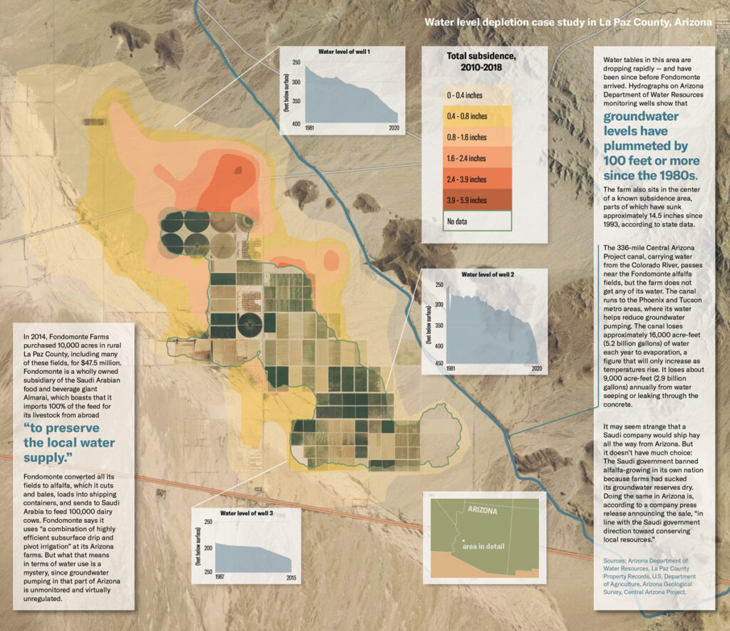
States, Congress, Trump okay $156M to extend innovative Platte River recovery program

The three-state Platte River Recovery Implementation Program was reauthorized by Congress and President Trump at the end of the year in a rare show of bi-partisan support for species conservation. Credit: PRRIP

By Jerd Smith

After a year of anxious waiting, scientists and researchers who’ve helped build one of the most successful species recovery programs in the nation have gotten a 13-year extension to finish their work.

The Platte River Recovery Implementation Program began operating in 2007 with the bi-partisan backing of Colorado, Wyoming, and Nebraska and the U.S. Department of the Interior. Since then it has created some 15,000 acres of new habitat for stressed birds and fish, and added nearly 120,000 acre-feet of new annual water to the Platte River in central Nebraska. An acre-foot equals nearly 326,000 gallons.

The region is critical because it serves as a major stopping point for migrating birds, including the whooping crane, the least tern and the piping plover.

In addition to helping fish, birds and the river, the program also allowed dozens of water agencies, irrigation districts and others to meet requirements under the Endangered Species Act, which can prevent them from building and sometimes operating reservoirs, dams and other diversions if the activity is deemed harmful to at-risk species.

Last year it wasn’t clear that three new governors, three state congressional delegations, and a fractious Congress could come together to re-authorize the program.

Jo Jo La, an endangered species expert who tracks the program for the Colorado Water Conservation Board, said everyone was grateful that politicians united to push the federal legislation, and the new operating agreement, through. It was signed by President Trump at the end of December.

“Our program was fortunate to have the leaders it had,” La said.

But it wasn’t just politicians who were responsible for the program’s extension, said Jason Farnsworth, executive director of the Kearney, Neb.-based program.

It was the diversity among the group’s members that was also key, he said. “Everyone from The Nature Conservancy to the Audubon Society to irrigation districts in the North Platte Basin supported this. You don’t often see an irrigation district sending a support letter for an endangered species recovery program. That’s how broad the support was.”

Of the $156 million allocated, Colorado is providing $24.9 million in cash and another $6.2 million in water, Wyoming is providing $3.1 million in cash and $12.5 million in water, Nebraska is providing $31.25 million in land and water, and the U.S. Department of Interior is providing $78 million in cash, according to PRRIP documents.

With their marching orders in hand, researchers and scientists can now focus on completing the program so that at the end of this 13-year extension it will become fully operational.

Early results have won accolades from Wyoming to Washington, D.C. The CWCB’s La said congressional testimony routinely described it as one of the “marquee” recovery programs in the nation, largely because, even though it isn’t finished, species are coming back in a major way.

In the 1980s and 1990s, the endangered whooping crane, least tern and pallid sturgeon, and the threatened piping plover, were in danger of becoming extinct, with the river’s channels and flows so altered by dams and diversions that it could no longer support the species’ nesting, breeding and migratory habitats.

Today the picture is much different.

The whooping crane spring migration has risen more than 12 percent since 2007, while the number of least tern and piping plover breeding pairs have more than doubled during that same time period, a major achievement in the species conservation world.

Still ahead is the work to acquire more water and land, and research to understand how to help the rare pallid sturgeon recover. Thus far it has not responded to recovery efforts, in part because it is extremely difficult to locate.

The idea is to ensure there is enough water and habitat to keep the birds and fish healthy once the program enters its long-term operating phase.

“The intent is to spend the next 13 years working on identifying the amount of water and land that is necessary to go into [the final operating phase]. The focus will be less on acquiring and learning, and more on operating and managing,” Farnsworth said.

Jerd Smith is editor of Fresh Water News. She can be reached at 720-398-6474, via email at jerd@wateredco.org or @jerd_smith.

This story originally appeared on Fresh Water News, an independent, non-partisan news initiative of Water Education Colorado. WEco is funded by multiple donors. Its editorial policy and donor list can be viewed at wateredco.org.

Counterfeits hit home: consumers are being foiled by fake water filters

More than 5,200 counterfeit refrigerator water filters from China were seized in July at the LA/Long Beach Seaport. (Photo by U.S. Customs and Border Protection)

By Nate Seltenrich, FairWarning, January 15, 2020

For years, Montreal resident Brent George bought replacement water filters for his refrigerator from a local appliance store. Then one time he turned to Amazon, where he often shopped for other products. Besides being more convenient, the online filters he selected — sold by a third party and not by manufacturer Whirlpool  were also cheaper.

Ultimately, George got more than he expected: an introduction to the hidden and potentially harmful world of counterfeit refrigerator water filters. Many consumers may be unaware of the risk of buying fake filters online, but sources in law enforcement and the appliance industry say it’s significant — and likely growing.Want more stories like this? Sign up here to get news alerts.

Refrigerator filters are an attractive target for unscrupulous sellers looking to make a quick buck. They’re pricey (typically up to $50), purchased every six months at the behest of large corporations, and often difficult for consumers to evaluate.

By slapping some labels, packaging and fake certifications on lookalike filters with little functionality, then selling them online at discounted prices — directly to consumers or via intermediaries who may not always be in on the act — counterfeiters can undercut legitimate manufacturers and still turn a profit.

Fake filters “in the millions”

They may also be putting consumers at risk by selling filters that are not merely ineffective, but unsafe. Along with failing to do what they claim, counterfeits can introduce chemicals such as arsenic, a carcinogen, and octane, a petroleum-derived solvent, into users’ drinking water, according to a May 2018 report from the industry group Association of Home Appliance Manufacturers.

The organization representing more than 100 appliance brands and suppliers has argued for better protections against fake filters in meetings with Amazon, the Consumer Product Safety Commission, the National Intellectual Property Rights Coordination Center and the White House, said Jill Notini, the group’s spokeswoman. Its efforts have stirred interest in the issue, she said, but not much action.

Neither the association nor three major filter manufacturers could tell FairWarning how much counterfeiting costs the companies in lost revenue. But Notini said the group estimates the number of fake water filters to be “in the millions.”

And the threat appears to be increasing. Between 2016 and 2018, seizures of fake refrigerator water filters at U.S. ports grew considerably. In all, Customs and Border Protection seized more than 150,000 such products or related parts in dozens of cases nationwide, according to the agency’s most recent data, provided to FairWarning.

In July, customs officers at the Los Angeles/Long Beach Seaport, which accounts for 43 percent of all cargo entering the United States, seized 5,200 counterfeit filters from a shipment of various products sent from China to an address in Washington state.

Notini said she understood that the filters, which mimicked the brands Brita, GE, Frigidaire and PUR, were headed to a known Amazon seller. Customs and Border Protection spokesman Jaime Ruiz confirmed only that the products were intended to be sold “in an online store.”

Packaging can be tip-off

Soon after George received his two new filters in the mail, he began to suspect that something was wrong. “When they showed up, they were suspiciously wrapped,” he said in an interview with FairWarning. The hard plastic shell and softer plastic wrap looked “sloppy” and bore water spots, almost as if they or the filters had previously been used.

“And I distinctly remembered holographic stickers on the ones I bought before, and suddenly I noticed that was missing,” he said.

George said he reached out to Whirlpool to ask if there was any chance a legitimate replacement filter would lack a holographic sticker. He was told no. After reporting the alleged fraud, he received a refund from Amazon and a contrite note from the seller. He discarded the filters before they ever reached his fridge.

Many other consumers may not be so lucky, though it is difficult to say how many. Counterfeits by their very nature are difficult to track, especially when they’re not expected — as is often the case with replacement water filters. Most probably go undetected, Notini said.

Buyers who suspect they’ve been duped may reach out to the seller, the marketplace, the manufacturer of the copied product or various government agencies. What happens next varies – from criminal prosecution to a slap on the wrist.

Amazon spokeswoman Cecilia Fan said the company investigates any claim of counterfeiting thoroughly, “including removing the item, permanently removing the bad actor, pursuing legal action or working with law enforcement as appropriate.”

In the case of the July seizure in Los Angeles, the importer was not prosecuted but likely lost a lot of money, said Ruiz. “We believe that this would deter the importer to try to smuggle filters again.”

Ferreting out fakes at the nation’s ports is a complex and daunting process with the arrival every year of 11 million containers at sea ports, 10 million coming in on trucks, and another 3 million by rail, he explained.

Federal agents target lookalikes

Last year, Customs and Border Protection seized nearly 34,000 shipments containing counterfeit goods, or nearly 100 per day.

Officers track every container and its contents electronically. They use “sophisticated targeting systems” to call attention to new businesses and changed addresses or product types, Ruiz said. “Anything in the system that could create an anomaly raises a red flag.”

If counterfeits are found, they are seized and destroyed. “Our goal is to facilitate and expedite trade, but we also want to make sure products are in compliance with U.S. law,” Ruiz said.

But the agency isn’t keeping pace with online counterfeiters and needs to coordinate better with the private sector, according to a 2018 report by the U.S. Government Accountability Office. “Sharing additional information about seized items with rights-holding companies and e-commerce websites could improve enforcement,” the report stated.

Theoretically, a single faulty refrigerator filter could taint thousands of glasses of drinking water, Notini said.

For her organization’s 2018 report, three independent laboratories assessed different aspects of fake filters’ performance. Known counterfeits were purchased online by appliance manufacturers including LG, Electrolux, Samsung, Whirlpool, GE Appliances and Sub-Zero.

According to the report, one lab found that all 32 counterfeits it tested failed to meet advertised standards for lead removal. Another lab tested eight filters for removal of the microscopic parasite Cryptosporidium parvum, a common cause of waterborne disease in the United States, and again none passed.

The third lab soaked 46 filters in clean water to see if they’d leach new chemicals. Some, but not all, contaminated the water with a total of ten different compounds — including, in one case, arsenic at levels approaching federal drinking-water limits.

“Unlike food grade materials used in certified filters that are tested and approved,” the report reads, “these counterfeits likely used cheaper, non-food grade materials, which are known to leach these kinds of chemicals.”

Counterfeiters roost on Amazon

Amazon largely relies on two programs called Brand Registry and Project Zero to keep counterfeits off its site, whether that means water filters or handbags, said spokeswoman Fan. Both require manufacturers and brand owners to be proactive by providing detailed product information and reporting suspected fakes for immediate removal.

“We absolutely don’t want counterfeit products, and so there’s a lot that we do, but ultimately, brands are going to know their products better than anybody else,” she said.

More than 5,200 counterfeit refrigerator water filters from China were seized in July at the LA/Long Beach Seaport. (Photo by U.S. Customs and Border Protection)

Port officials snagged counterfeits of popular water filter brands in a July seizure at the LA/Long Beach Seaport. (Photo by U.S. Customs and Border Protection)

A separate system scans product reviews for claims of inauthenticity, which can then be investigated, Fan added.

Amazon’s policy for sellers requires that all water filters be certified to current standards by one of a handful of reputable outfits. But that doesn’t stop sophisticated counterfeiters from faking that, too, reproducing the National Sanitation Foundation’s widely trusted “NSF” logo, said Notini.

The e-commerce and auction site eBay — where a recent search for “refrigerator water filter” turned up more than 25,000 listings, representing untold numbers of individual filters — doesn’t have any special policies for filters at all. According to a spokeswomanthe company primarily depends upon customers and brands to report suspected fakes.

Counterfeiters are also finding customers through independent, often generic-sounding websites that specialize in selling water filters at reduced prices, said GE Appliances spokeswoman Julie Wood.

“Our company is seeing an increased trend in direct shipment of counterfeits, from foreign sellers to U.S. addresses,” Wood said. “We have seen several discount websites that we believe advertise, perhaps unwittingly, counterfeit or deceptive knock-off water filters.”

In the last year alone, officers have seized almost 14,000 counterfeit GE-branded refrigerator water filters at the nation’s ports, she added.

Jillian Hillard, director of ownership marketing for Sweden-based appliance manufacturer Electrolux, said that in addition to buying straight from the company, customers seeking a sure thing can use a search function on its website to locate authorized retailers, many of which also sell filters online.

Industry aims to educate public

“Counterfeits and knockoffs are a concern for all industries,” Hillard said. “Manufacturers like us want to protect our product, we want to protect our brand, and we want to protect the consumer.”

In hopes of slowing counterfeiting’s spread, Electrolux and its U.S. subsidiary Frigidaire are both working to raise its profile. Newly released educational videos and other materials are designed to “let consumers know that they have to be aware of counterfeits and knockoffs, and what the key criteria for spotting them are,” Hillard said.

In addition to costing less, fake filters often weigh less and come in similar, but poorer-quality packaging. The product, packaging or online listing may also contain misspellings or other typographical errors.

Notini, who leads the appliance-manufacturers association’s anti-counterfeit efforts from Washington, D.C., is prepared for a protracted battle.

“The counterfeiters try to stay one step ahead,” she said. “We’re trying to beat the drum because it’s not an issue that’s going to go away.”

This story was produced by FairWarning (www.fairwarning.org), a nonprofit news organization based in Southern California that focuses on public health, consumer and environmental issues.

The Water Desk’s mission is to increase the volume, depth and power of journalism connected to Western water issues. We’re an initiative of the Center for Environmental Journalism at the University of Colorado Boulder. The Water Desk launched in April 2019 with support from the Walton Family Foundation. We maintain a strict editorial firewall between our funders and our journalism. The Water Desk is seeking additional funding to build and sustain the initiative. Click here to donate.

Recent stories