Colorado communities from Greeley to Durango have identified $20.3 billion in water projects that will help ensure residents have adequate water, that agricultural supplies are protected, and that rivers and streams can continue to support fish and wildlife as population growth, chronic drought and climate change threaten future water supplies.
According to the 2015 Colorado Water Plan, the state faces a gap between expected demand and existing water supply of as much as 560,000 acre-feet per year for cities and industry by 2050.
Colorado is home to eight major river basins, each of which is governed by a public roundtable. A ninth basin roundtable represents the Denver metro area.
These entities are charged with evaluating each region’s water needs and projects that would help meet those needs. Funding for those projects will likely come from several sources including local governments and water utilities, and state and federal funding.
Known as basin implementation plans (BIPs), the working documents summarizing those projects and needs were submitted to the state earlier this month and are open for public comment through Nov. 15. These plans are updated versions of the originals that were initially developed by the roundtables in 2015 to inform the Colorado Water Plan.
Since 2015, the Colorado Water Conservation Board (CWCB), which is responsible for implementing the water plan, has spent some $500 million in grants and loans helping fund water projects across the state, according to Russ Sands, head of water supply planning at the CWCB.
The plans are a key part of Colorado’s larger statewide effort to ensure it has adequate water supplies. The Colorado Water Plan is the primary document that guides state water policy and it relies on the planning efforts of the local roundtables.
“The basin roundtables represent a grassroots initiative that allow access to state planning,” Sands said.
The South Platte and Metro basin roundtables, which submitted a combined plan, have the most costly project list at $9.8 billion. This figure includes costs of projects that are planned, currently being implemented, or recently completed.
The South Platte Basin is home to the largest population centers and covers metro Denver, Fort Collins, Boulder, Greeley and Sterling, among dozens of other communities.
The next largest project list comes from the Colorado River Basin on the West Slope. It has identified $4.1 billion in water projects that will help it ensure its residents’ future needs are addressed.
The roundtables, made up of water professionals, citizens and local elected representatives, receive funding to operate from the CWCB. They also help fund projects each deem important to meeting a local need, whether it is improving an irrigation company’s diversion structure, building a new reservoir, funding a stream restoration project, or building a new kayak park.
The plans are “important because the process was to identify gaps in what a basin needs for irrigated agriculture, municipal and industrial, and environmental and recreational needs,” said Jason Turner, who chairs the Colorado River Basin Roundtable. “We have a robust mix of all sorts of projects and it allows people who, say, live on the Roaring Fork [a tributary] to understand some of the bigger Colorado River issues as well.”
Barbara Biggs is chair of the Metro Roundtable. She said the project list for the combined South Platte and Metro roundtables represents one of the most detailed assessments of water needs on the Front Range.
“Just creating the project database is a huge step in the right direction because it will allow us to track and measure our success,” she said.
The basin plans are scheduled to be finalized at the end of January 2022 and will be incorporated into an update of the 2015 Colorado Water Plan next year.
Jerd Smith is editor of Fresh Water News. She can be reached at 720-398-6474, via email at jerd@wateredco.org or @jerd_smith.
Fresh Water News is an independent, nonpartisan news initiative of Water Education Colorado. WEco is funded by multiple donors. Our editorial policy and donor list can be viewed at wateredco.org.
The Water Desk’s mission is to increase the volume, depth and power of journalism connected to Western water issues. We’re an initiative of the Center for Environmental Journalism at the University of Colorado Boulder. The Water Desk launched in April 2019 with support from the Walton Family Foundation. We maintain a strict editorial firewall between our funders and our journalism.
May 14, 2021 — Editor’s note: This story is part of a collaboration, Tapped Out: Power, justice and water in the West, in which eight Institute for Nonprofit News newsrooms — California Health Report and High Country News; SJV Water and the Center for Collaborative Investigative Journalism; Circle of Blue; Columbia Insight; Ensia; and New Mexico In Depth — spent more than three months reporting on water issues in the Western U.S. The result documents serious concerns including contamination, excessive groundwater pumping and environmental inequity — as well as solutions to the problems. It was made possible by a grant from The Water Desk, with support from Ensia and INN’s Amplify News Project.
A riverbed that has been parched since the end of the 19th century — a portion of the historic lifeblood of the Gila River Indian Community — is now coursing again with water, luring things like cattails and birds back to its shores.
“You add water and stuff just immediately starts coming back naturally. Birds have returned and it’s just such a different experience,” says Jason Hauter, an attorney and a Community member. “It’s amazing how much has returned.”
The revival of this small segment of the 649-mile (1045-kilometer) Gila River, which has served the tribes that make up the Gila River Indian Community — the Akimel O’odham (Pima) and the Pee-Posh (Maricopa) — for roughly 2,000 years, was an added benefit of a grassroots infrastructure overhaul, known as “managed aquifer recharge,” or MAR, which aimed to restore the local groundwater basin. The MAR project has not only secured a water supply for local agriculture, but it has also generated a stable source of income and strengthened the Community’s ties to tradition.
“The land started to heal itself, reinvigorate itself,” says Governor Stephen Roe Lewis, who recently began his third term as leader of the Gila River Indian Community.
Hauter credits Lewis and his colleagues for ensuring that Community members have long-term access to their own resources while helping solve broader water supply problems in the region through innovative partnerships and exchanges with neighbors.
“They are very thoughtful about future generations, but they also recognize they live in this larger community and that you have to collaborate,” Hauter says. “Encouraging your neighbors to have good water practices, but also helping your neighbors, is good water policy.”
A Particularly Longstanding Claim to Water Rights
The ins and outs of water management and usage in the U.S. West are complex. In a region where every drop is important, questions about water — such as who gets what, how it’s moved from one place to another, and who pays for it — are vital to communities’ capacity to survive and thrive. These decisions are often based on century-plus-old legal doctrines that don’t always fit neatly into a modern, warming world — or address longstanding disregard for Native American tribal nations’ rights.
Western U.S. states adhere to legal doctrines called “prior appropriation” — sometimes referred to as “first in time, first in right” — linked to the mid-19th century Gold Rush and the Homestead Act, through which miners and farmers were able to claim and divert water sources for “beneficial use” — defined by activities such as irrigation, industry, power production and domestic use. A 1908 Supreme Court case ruled that the federal decision to establish Native American reservations inherently meant there would be sufficient water for those reservations. The priority date for water rights on these reservations therefore had to match the date of establishment, meaning that many tribal nations’ water rights took precedence over those of most existing users. During the past few decades, these nations have largely opted for settlements with the relevant federal, state and private bodies, rather than entering extensive and costly litigation to recover their water rights.
These settlements allow tribal nations to take part in the competitive markets that have long ruled water in the West. These markets involve things like selling water rights, getting money for helping mitigate drought and accruing “credit” from the Arizona Water Banking Authority by storing water in underground basins administered by the Arizona Department of Water Resources.
One such pivotal settlement came in 2004: To resolve tribal water rights claims, Congress passed the Arizona Water Settlement Act, which allocates a set amount of water each year to the Gila River Indian Community, drawing that water budget from a variety of sources in Arizona. The Community had a particularly longstanding claim to water rights due to its two-millennia history of farming, curtailed when miners and white settlers began diverting water following the Civil War. The governor’s late father, Rodney Lewis, devoted his career as Gila River Tribal Attorney to fighting for a just water settlement.
“It was the theft of our water, so this was a generational historic struggle to regain our water,” Lewis says. “We were and we still are historically agriculturalists, farmers. Our lineage, our ancestors were the Huhugam. And the Huhugam civilization had pretty much cultivated the modern-day Phoenix area in central Arizona.”
“They were master builders,” he adds, referring to complex water systems and canals that he says rivaled those of the Nile Valley.
As more and more nations regain control of their water resources, they are securing a critical provision for the long-term financial prosperity of their people and protection of their lands.
Mutually Beneficial Partnerships
As often occurs in tribal water rights settlements, the 2004 agreement served to restore the Gila River Indian Community’s claims to the river and its tributaries without displacing the descendants “of those who committed the original sin,” says Hauter, a partner at the law firm Akin Gump Strauss Hauer & Feld, which currently serves as outside counsel for the Community.
Toward that end, Hauter says, “really, what’s provided is an alternative supply.”
That alternative supply comes from the Central Arizona Project (CAP), an infrastructural behemoth that conveys about 1.5 million acre-feet (1.85 billion cubic meters; one acre-foot is about 326,000 gallons) of water from the Colorado River to central and southern Arizona each year. Serving as the single largest renewable water supply for the state of Arizona, the 336-mile (540-kilometer) system was authorized by then-President Lyndon B. Johnson in 1968, soon after which construction by the Bureau of Reclamation began. Three years later, the Central Arizona Water Conservation District — a multi-county water district — formed to repay the federal government for the project’s costs and oversee regional water supply.
Through the 2004 settlement, the Gila River Indian Community has the single largest CAP entitlement — bigger than that of the city of Phoenix — at 311,800 acre-feet (385 million cubic meters), Hauter explains. Finding mutual benefit in helping quench the thirst of the surrounding region, the Community entered into various water exchanges and leases that delivered about 60,000 acre-feet (74 million cubic meters) to Phoenix and other municipalities annually and left about 250,000-acre-feet (308 million cubic meters) for its own purposes, according to Hauter.
But this sudden surplus from the CAP actually posed a problem.
Pumping water from the project, Community members understood, would eventually become prohibitive due to water transport and associated electricity costs. The Lower Colorado River Basin Development Fund, managed by the U.S. Department of Interior, covers the Fixed OM&R (operation, maintenance and replacement) for certain Arizona tribes with settlements, but funding is only projected to last until 2045, Hauter explains.
The Community was using only about 50,000 acre-feet (62 million cubic meters) for irrigation purposes, leaving about 200,000-acre-feet (247 million cubic meters) unused, Hauter says. Because any unused CAP water can be remarketed by the state, Arizonans began counting on the Community to not use its full share.
With the legal guidance of Hauter and his team, the Community launched a strategic venture to store, share and sell much more of its CAP water in 2010.
The first such partnership occurred with former water supply rival the Salt River Project, the name of the utilities responsible for providing most of Phoenix’s water and power. Had the Community decided to enter litigation to recover its water rights, rather than settling, the Salt River Project could have faced enormous supply losses.
But the former rivals instead became partners, after identifying that the Salt River Project’s underground storage facility (USF), the Granite Reef Underground Storage Project, was an ideal place to store a portion of the CAP allocation the Gila River Indian Community was not currently using. The partnership has enabled the Salt River Project to withdraw water from storage — while maintaining a “safe yield,” or making sure any water that is taken from aquifers is replenished. In return, the Community has gained long-term storage credit, Hauter explains. Such storage credit enables the holder to bank CAP water and, when necessary, recover the water for future use.
The Community also stores water in groundwater savings facilities (GSF), including one operated by the Salt River Project and another south of the Gila River operated by the Maricopa Stanfield Drainage District. While a USF physically stores water in the aquifer through direct recharge, a GSF is an “indirect” recharge facility that uses CAP water instead of pumping local groundwater.
In what Hauter described as an “in lieu” agreement, the Community provides the operators of these GSF facilities with a renewable water supply — another portion of its CAP allocation — and so reduces the Salt River Project and Maricopa District’s need to extract groundwater. In return, the Community gets storage credit for the water that can remain in the ground.
“Everything We Needed Was at the River”
While these external collaborations bolstered the resilience of the Community, as well as that of the arid surrounding region, Gila River residents only really saw the revival of their long-lost local waterway when Community leaders launched a homegrown storage initiative. Recognizing the value in keeping some unused CAP resources at home, they chose to establish a network of managed aquifer recharge (MAR) sites. This type of underground storage allows for the free flow of water from a naturally permeable area, such as a streambed, into an aquifer, as opposed to “constructed recharge” sites that involve injecting water into percolation basins by means of a constructed device.
In order to implement these plans, the Gila River Indian Community came to an agreement with Arizona to acquire state regulatory permits for the MAR projects, despite the fact that tribal nations have sovereign control over water management. As a result of this decision, the Community has been able to market long-term storage credits in a sort of environmentally friendly banking system that allows more groundwater to stay in the ground.
“They realized they could get multiple benefits from deciding to have their project permitted per the Arizona regulations,” says Sharon Megdal, director of The University of Arizona Water Resources Research Center.
“They voluntarily chose to abide by the regulations for storage and recovery and therefore come under the whole credit accrual and accounting system,” she continues, stressing that not only can credits be used to recover water when needed in the future, but they can also be purchased by outside entities, which creates a revenue stream for the Community. “That’s really exciting.”
Three MAR facilities are already operating on the reservation today: MAR-5, the Olberg Dam underground storage facility, permitted in 2018; MAR-1B, the Cholla Mountain underground storage facility, permitted in 2020; and MAR-6B, a western and downstream expansion of MAR-5, which came online a few months ago. Construction of MAR-8, located downstream from MAR-5, will be complete in a few years, according to Hauter.
Hauter adds that it was only while planning the initial MAR-5 site that Community members envisioned the riparian restoration program that served “to recreate the river,” allowing cattails and other plants to blossom and enabling community members to create baskets and traditional medicines. Although the idea of restoring the river was secondary to the storage plans, Hauter says that its flow is intrinsic to the Community’s culture.
“The tangible benefit for most members is really having the river back to some degree,” Hauter adds. “It wasn’t something the settlement intended to accomplish, but the settlement gave the Community the tools to make it happen.”
Lewis and his father, who had already retired at the time, used those tools to see the first MAR site to fruition. The Lewises and their colleagues understood the benefit in adopting innovative methods for accumulating water at their future storage site.
“He truly saw the MAR-5 as a living testament to our historic tie to the Gila River,” the governor says, adding that his father considered the facility an opportunity to “return the flow of the river.”
With the revived river flow, the riparian habitat quickly began blossoming, including 50 documented species of birds within the first year of MAR-5’s operations, Lewis says. An interpretive trail now weaves through the once arid wetland, providing educational signposts and offering sacred cultural spaces for spiritual practice, Lewis explains. Elders are now taking advantage of the plants and silt available to engage in traditional basket weaving, medicine making and pottery, he adds.https://www.youtube.com/embed/z52k5NB02cM?feature=oembed
“They still remember the river sometimes flowing and the smell of the water,” Lewis says.
In recent years, before the opening of the MAR-5 site, the channel filled with water only in particularly wet seasons involving floods or heavy snowpack upstream, according to Lewis.
“Everything we needed was at the river,” he adds. “That was our lifeblood.”
Continuing to Plan For a Drought-Ridden Future
In conjunction with the opening of the MAR facilities, the Community cemented a pivotal agreement in 2019 with the Central Arizona Groundwater Replenishment District (CAGRD), a groundwater replenishment entity operated by the Central Arizona Water Conservation District. Through this agreement, CAGRD leases 18,185 acre-feet (22 million cubic meters) of the Community’s CAP water and stores the majority of that water in the MAR sites, while receiving long-term storage credits in return from the Arizona Water Banking Authority. Only if the MAR facilities are full is CAGRD allowed to store the leased water elsewhere, Hauter explains.
Alongside the MAR projects, the Community has also been rehabilitating existing wells and building new ones in order to create a backup supply for agricultural use when Gila River flow is minimal. Well water is less expensive than CAP water, since wells can recharge naturally during storms — so much so that such events collectively add at least 100,000 acre-feet (123 million cubic meters) to the Community’s annual water supply, according to Hauter. The Community took additional steps to reroute its CAP supplies after the federal government and the seven Colorado River Basin States implemented their drought contingency plans, meant to elevate water levels in Lake Mead, in 2020. As part of that regional effort, Hauter explains, the Community is providing a total of at least 200,000 acre-feet (247 million cubic meters) of water to be stored in Lake Mead from 2020 to 2026, when the drought contingency plans expire. For its contribution, the Community gets money through the Arizona Water Bank and the Bureau of Reclamation.
Only through the Community’s creative collaborations and homegrown projects has so much of its CAP entitlement been able to help replenish Lake Mead, Hauter says. Today, the Community has reduced its CAP water usage for irrigation to 15,000 acre-feet (19 million cubic meters) per year, while its CAP water storage capacity in the MAR projects is up to about 40,000 acre-feet (49 million cubic meters) per year. After construction of MAR-8 is complete, total CAP water use for storage and irrigation will reach about 75,000 acre-feet (93 million cubic meters), Hauter says.
As the Community’s leaders continue to plan for a drought-ridden future, they are evaluating whether it will be necessary to use more of its CAP allocation for their own needs. At the moment, much of the reservation’s agriculture involves water-intensive crops like alfalfa, feed corn and cotton. An overhaul of the farming infrastructure, according to Hauter, would require “changing attitudes about how food is grown” and incorporating more efficient technologies, as well as encouraging farming among younger people.
Overall, Hauter says, “it’s an exciting future for the Community, and it will be interesting to see what happens in the next 20 or so years.”
Lewis is confident that the Community’s agricultural tradition will remain strong, particularly due to the younger generation’s concerns for social justice, equity and environmental issues.
“We want to provide opportunities for our community members to reengage in any way in our agricultural heritage,” he says. “We’ve always been innovators, going back to the Huhugam with their amazing engineering.”
In addition to the commercial company Gila River Farms, which is owned by the tribe and employs Community members, Lewis says that local family farms continue to thrive. Lewis also says that “there’s a big push” for young people to obtain degrees in agro-business, hydrology, water engineering and other relevant fields that will provide them with a livelihood while working for their Community — a place that has become even more special to them during the pandemic year.
“It’s a public health emergency that we’ve been going through,” Lewis adds. “But at the same time, I think this is an opportunity where you see a lot [of] our younger generation that are wanting to learn who it is to be from the Gila River Indian Community.”
“A Total Win-Win”
While the MAR projects and the larger water exchange deals serve to safeguard the Community’s water supplies, Hauter says he’s uncertain as to whether neighboring tribal nations could replicate this model. Other tribes, he explains, might have different agricultural interests or economic concerns, as well as varying geological and hydrological conditions.
In Megdal’s opinion, at least one aspect of the Community’s strategy could be replicable regardless of geography: the strategic accrual and marketing of long-term storage credits in permitted recharge facilities. The Gila River Indian Community has diversified its portfolio of storage credit and sales through “multiple vehicles,” she explains, including its MAR projects, the Salt River Project partnership, and its transfer of credits to CAGRD.
“They are able to meet their objectives including having riparian benefits and river benefits and sell the credits — because the credits are then recovered elsewhere. … For them, it’s like a total win-win,” Megdal says, adding that she considers the Community’s achievements to be “a bellwether project.”
Already, she says, the Tucson-region Tohono O’odham Nation has begun selling some credits to CAGRD. Acknowledging that the two cases involve varying geological and legislative circumstances, Megdal stresses that the Gila River Indian Community has demonstrated the benefits of the storage and credit accrual system.
“These long-term storage credits are the most marketable part of the water system,” Megdal says. “It’s an emerging market, and the Gila River Indian Community has emerged as a key leader in that market.”
“I see this example of a tribal nation entering voluntarily into an intergovernmental agreement with the state so that all the parties can develop these mutually beneficial exchanges or marketing transactions in a voluntary way,” she adds. “It’s really a notable innovation.”
Editor’s note: This story is also part of a four-part series — “Hotter, Drier, Smarter: Managing Western Water in a Changing Climate” — about innovative approaches to water management in the U.S. West and Western tribal nations. The series is supported by a grant from the Water Desk at the University of Colorado Boulder and is included in our nearly year-long reporting project, “Troubled Waters,” which is supported by funding from the Park Foundation and Water Foundation. You can find the other stories in the series, along with more drinking water reporting, here.
About one-third of Navajo Nation residents lack running water in their homes and water pollution remains a serious issue in the region. We talk to Kaitlin Harris of DigDeep’s Navajo Water Project about solutions to these pressing problems.
Kaitlin Harris, DigDeep Navajo Water Project Kaitlin is a field engineer for the Navajo Water Project, a grant and donation-funded effort to bring drinking water and sanitation services to remote communities in the Navajo Nation, which is roughly the size of West Virginia.
Water challenges on the Navajo Nation As in many indigenous communities, infrastructure in the Navajo Nation has long been underfunded. A four decade legacy of uranium mining has left a lot of pollution as well. The Nation’s dispersed population also makes it more difficult to provide water service. Starts at 4:18
If you’re interested in appearing on the show, please contact Water Desk Director Mitch Tobin at mitchtobin@colorado.edu. If you’d like to share your comments and questions, you can reach us at waterdesk@colorado.edu, or on Twitter and Facebook.
A rafter on the Colorado River looking upstream toward Glenwood Springs. The Colorado River in Glenwood Springs has seen a 6% reduction in flow, when comparing records from 2000-2019 to 1906-1999, while the San Juan River near Bluff, Utah, has declined by 30%, according to the research. CREDIT: BRENT GARDNER-SMITH/ASPEN JOURNALISM
New climate data that shows a north/south split in streamflow declines in the Colorado River basin could have implications for water managers as they navigate how to address water shortages.
This month, Brad Udall, senior water and climate research scientist at Colorado State University, presented data that shows when comparing records from the past 20 years to those from most of the 20th century, rivers in the southern half of the upper Colorado River basin have lost a larger percentage of flows than rivers in the northern part of the basin.
For example, flows on the San Juan River near Bluff, Utah, have declined by 30% and flows on the Dolores River near Cisco, Utah, have declined by 21%. Flows on the Yampa River near Maybell and the Colorado River near Glenwood Springs have each lost just 6% of flows.
“We do think it’s going to dry more in the south and less in the north and we should at some point see a gradient, and sure enough, that has popped up at some of these gauges,” Udall said.
Udall presented his findings at the University of Colorado Getches-Wilkinson Center’s 41st annual Colorado Law Conference on Natural Resources, which was simulcast as part of the Colorado River Water Conservation District’s annual seminar on Oct. 1.
Udall analyzed the Bureau of Reclamation’s natural flow data, which is an estimate of the flow that would have been observed at a stream gauge if there were no reservoirs or diversions present. Then he compared 1906-99 data to 2000-19 data to see how much the flows have declined.
Udall said the data was just an initial look; more research needs to be done, and there is at least one outlier that bucks the trend: The White River, which flows through the northwest corner of Colorado, has experienced a 19% decline in flows at the Watson gauge, which is just over the state line in Utah.
“Are the natural flows conveying accurately what’s going on? I just don’t know,” Udall said. “When you begin to do science, you come up with these results that bear more digging.”
Lake Powell is seen in a November 2019 aerial photo from the nonprofit EcoFlight. Data that shows streamflows are declining more in the southern part of the upper Colorado River basin could influence how the state of Colorado develops a program that would pay water users to use less and send the saved water downstream to Lake Powell. CREDIT: ECOFLIGHT
Warming temperatures
A 2017 paper co-authored by Udall and Jonathan Overpeck found that an average of one-third of the Colorado River’s flow loss could be attributed to warming temperatures. Higher temperatures may even cancel out any increases in precipitation.
“The hotter it is, the thirstier the air is for water, so it’s going to pull more moisture out of the soil or the crops or the reservoir or whatever the case may be,” CSU climatologist Russ Schumacher said. “As the snow starts to melt, it has to go back into recharging the soil. That’s the first place it goes, and not as much ends up in the rivers.”
Schumacher said the north/south flow-loss differential is consistent with what climate predictions have shown.
“The interior Southwest of the United States is a place that is especially vulnerable because it’s a dry place to begin with,” he said. “Adding more heat into the system, you get more evapotranspiration and everything else, and we are seeing rivers decline there.”
The dividing line between drier and wetter is somewhere near the middle latitude of Colorado and bisects the state into northern and southern halves. Also, it is roughly where the main stem of the Colorado River flows through the state. But as the impacts of climate change worsen, high pressure over the deserts of the Southwest could creep northward and expand the more intense streamflow losses already happening in the southwestern part of the state to the northern half of Colorado.
“The difficulty with climate change is that it’s changing,” Udall said. “This is a moving target throughout the 21st century, and every time you think you have it figured out, something else is going to happen.”
This map shows the south-to-north flow losses in the upper Colorado River basin, based on natural flow data from the Bureau of Reclamation. The White River, which flows through northwestern Colorado, is an outlier that climate scientist Brad Udall says needs more study.
Equity in demand management
The north/south difference in flow declines could have implications for how Colorado water managers develop a potential water-savings plan. State officials are currently investigating a program known as demand management that would pay water users to cut back and send the saved water to a special storage pool in Lake Powell. The water would be an insurance policy against a Colorado River Compact call.
A compact call could occur if the upper-basin states (Colorado, Wyoming, Utah and New Mexico) can’t deliver the 7.5 million acre-feet of water per year to the lower-basin states (Arizona, California and Nevada), as required by a nearly century-old binding agreement. Colorado water managers desperately want to avoid a compact-call scenario, which could result in mandatory water cutbacks.
A major topic of demand-management discussions has been proportionality and how to design a program that ensures that no particular river basin experiences more negative economic or environmental impacts than another. Another question is: If there is a compact call, how would state engineers administer it so that already water-short basins aren’t forced to cut back even more?
“(The north/south flow-loss differential) would be an interesting input into that, especially in the area of equity,” Udall said. “If the upper part of the (Colorado River) main stem is actually not suffering very much but the San Juan is really suffering, what does that mean for who should help contribute to the shortfall?”
Ken Curtis, general manager of the Dolores Water Conservancy District, said he has noticed a warming trend in southwest Colorado and that irrigators have seen an increasing number of shortages over the past 20 years. He has been monitoring the demand-management discussions and questions surrounding proportionality.
“This year, we were substantially worse than the rest of Colorado,” Curtis said. “You overlay the question, if this is a real pattern, how does this play into equitability? You can’t really get blood out of a turnip. There wasn’t any water to demand manage this year.”
State officials say they are striving to avoid disproportionate impacts on certain basins or water users as they continue their investigation into a demand-management program. Colorado Water Conservation Board Deputy Section Chief Amy Ostdiek said climate change and drought factor into everything the organization does.
“Talking about the southwest corner of the state, just what we are seeing on the ground is that it has been heavily impacted by drought and that has a number of implications,” she said. “In terms of demand management, there are going to be issues and concerns that are specific to each area of the state, for sure.”
But regardless of how the flow loss breaks down among the different tributaries of the upper basin, the overall streamflow trend is downward. According to Udall’s data, the Colorado River at the all-important Lee Ferry — just downstream from Lake Powell near the Arizona-Utah border, which is the dividing line between the upper and lower basins and the point at which upper-basin water deliveries to the lower basin are measured — has lost 17% of its flow. Despite a near-average snowpack, 2021 saw the second-worst unregulated inflow into Lake Powell, at 31% of average. This summer federal officials began emergency releases from upper-basin reservoirs to prop up levels in Lake Powell to maintain the ability to make hydroelectric power.
Eric Kuhn, former general manager of the River District and co-author of “Science Be Dammed: How Ignoring Inconvenient Science Drained the Colorado River,” said it is this bigger picture that should have upper-basin water managers worried, especially when it comes to plans for future water projects.
“We are thinking it, but we aren’t saying it out loud: There’s no more water,” Kuhn said. “There’s just not a lot of water for development. It’s an obvious conclusion right now. It’s the elephant in the room in the upper basin.”
Aspen Journalism covers water and rivers in collaboration with The Aspen Times and other Swift Communications newspapers. This story ran in the Oct. 16 edition of The Aspen Times, the Glenwood Springs Post-Independent, the Oct. 17 edition of the Vail Daily and Oct. 18 edition of SkyHi News.
The Water Desk’s mission is to increase the volume, depth and power of journalism connected to Western water issues. We’re an initiative of the Center for Environmental Journalism at the University of Colorado Boulder. The Water Desk launched in April 2019 with support from the Walton Family Foundation. We maintain a strict editorial firewall between our funders and our journalism.
Photographs by Ted Wood from our multimedia collection.
The Water Desk is excited to be partnering with photojournalist Ted Wood to expand our free multimedia library of water-related imagery.
Our library has thousands of photos of key locations in the Colorado River Basin and beyond. We also offer aerial videos, some of them captured with drones and others filmed during flights with our partner LightHawk.
The imagery in our library is available for editorial and non-commercial use under a free Creative Commons license. See this page to learn how journalists, media outlets and non-profits can license the content.
Learn more about how journalists, media outlets and non-profits can license the multimedia content.
Because so many media outlets, especially smaller and non-profit news organizations, have little to no money to pay for photos or videos, we want to provide a free resource to strengthen their water coverage.
At the same time, we recognize that many larger outlets do have the ability to pay for photos, so we’re encouraging them to hire photojournalists and asking them to donate to The Water Desk if they use free content from our library. We’ll devote all those donations to supporting photojournalists covering water issues.
For starters, we’ve published Ted’s images of Blue Mesa Reservoir, along Colorado’s Gunnison River, and Flaming Gorge Reservoir, which impounds the Green River in Wyoming and Utah.
Flaming Gorge Reservoir stores water from the Green River in Wyoming, and is shared by Wyoming and Utah.
These two reservoirs—parts of the Colorado River Storage Project—have been partially drawn down to prop up Lake Powell and preserve hydropower generation at Glen Canyon Dam.
Because so many media outlets, especially smaller and non-profit news organizations, have little to no money to pay for photos or videos, we want to provide a free resource to strengthen their water coverage.
Our library also has photos and videos of Navajo Lake, the third reservoir in the system that will help fill Lake Powell. I was able to visit there in April and August.
We’ve got a lot more content than just dams and reservoirs. For example, Ted’s photos of the Santa Cruz River illustrate a restoration project near my former home in Tucson.
We’re excited to roll out more of Ted’s images in the weeks and months ahead. Be sure to follow us on Twitter and Instagram to learn when we publish new content. And check out our interactive map for an overview of the multimedia library and to search by location.
If you’re a journalist working on a Western water story and need help finding a photo or video, please contact me at mitchtobin@colorado.edu. We’d also welcome any feedback on the library.
I want to thank Ted for contributing such great content and also give a shout-out to our consultant, Geoff McGhee, who helped us create a system for organizing and sharing photos and videos.
We hope this imagery offers a valuable asset for the field and helps enrich your understanding of Western water issues.
The Water Desk’s mission is to increase the volume, depth and power of journalism connected to Western water issues. We’re an initiative of the Center for Environmental Journalism at the University of Colorado Boulder. The Water Desk launched in April 2019 with support from the Walton Family Foundation. We maintain a strict editorial firewall between our funders and our journalism.
The far bank of the Yampa near the Flour Mill will get additional vegetation and trees to help cool river temperatures as part of this restoration project that began last week. The city of Steamboat is exploring a water quality trading program that could lower river temperatures and help the city comply with the permit requirements of its wastewater treatment facility. CREDIT: HEATHER SACKETT/ASPEN JOURNALISM
STEAMBOAT SPRINGS — The city of Steamboat Springs is exploring a way to help it stay in compliance with state regulations and also cool down chronically high temperatures in an impaired stretch of the Yampa River.
A program called water-quality trading could allow the city to meet the requirements of its wastewater-treatment facility’s discharge permit from the Colorado Department of Public Health and Environment by cooling other areas of the river by planting trees.
The Yampa River flows through downtown Steamboat, where several parks and the Core Trail have been built along its banks. The river, a vital and cherished amenity for the Steamboat community, is popular with tubers and anglers. According to a 2017 survey of citizens, 75% of respondents ranked the management and health of the Yampa as essential or very important.
But low flows and high temperatures, made worse in recent years by climate change, have impacted the public’s ability to use one of their favorite amenities. In July, the city closed the river to commercial use because of high temperatures — over 75 degrees. The city also recommended a voluntary closure for noncommercial users of the river.
The entire 57-mile segment of the Yampa from above the confluence with Oak Creek to above the confluence with Elkhead Creek often has temperatures that are too high during the summer months, and in 2016 the segment was designated as impaired for temperature under the Clean Water Act. For July, August, September and November, stream temperatures exceed state standards for a cold-water fishery.
Because the river is classified as impaired, city officials expect that when CDPHE issues a future discharge permit for the city’s wastewater-treatment plant, it will include more-stringent water temperature standards. The wastewater-treatment plant may not be able to meet these standards unless it cools the effluent before releasing it back into the river. The city’s current discharge permit expires at the end of the year.
According to CDPHE Marketing and Communications Specialist Eric Garcia, Steamboat’s next permit will likely not have temperature limits, but will have temperature monitoring requirements. The soonest the city would have temperature limits for the wastewater treatment plan is Jan. 1, 2027.
“These monitoring requirements are included so that we have a full understanding of the temperature issues in the Yampa River and at the plant before we set any temperature limits,” Garcia said in an email.
But just cooling the effluent won’t fix the temperature problems on the entire 57-mile stretch. The wastewater-treatment facility is not the cause of the high temperatures — an engineering study could not pinpoint an exact cause, and the plant is 12 miles downstream from the start of the impaired section — and city officials see an opportunity to improve the health of the Yampa on a holistic, watershed level. Instead of just cooling the water at the plant, the city hopes to use a program of cooling whole stretches of the river by planting more trees.
“Of course, building a cooling tower will help us meet our permit limit, but it won’t help solve the stream-temperature problem,” said Michelle Carr, water distribution and collection manager for the city. “It would go against what we are trying to achieve in the watershed entirely.”
The city of Steamboat discharges effluent from its wastewater treatment facility back into the Yampa River 12 miles downstream from the start of a section of river that has too-high temperatures. City officials expect that when CDPHE issues a new discharge permit, it will include more stringent temperature standards.CREDIT: HEATHER SACKETT/ASPEN JOURNALISM
Water-quality trading
Steamboat has been working with The Freshwater Trust, an Oregon-based group, to explore what a water-quality trading program could look like. The Freshwater Trust assessed 119 miles of local streams and found 794 acres where riparian plantings could work at a potential program cost of $1.5 million.
According to David Primozich, vice president at The Freshwater Trust, the vast majority of heat in the river comes from the sun, so providing shade is an effective way to keep stream temperatures from rising. Over the decades, development and agriculture operations along the Yampa have removed riverbank vegetation, especially narrowleaf cottonwoods. Replanting these big, shady trees, which can top at least 60 feet at maturity, can help.
Using a modeling tool called the Shade-a-lator, The Freshwater Trust can determine the potential reduction in solar loading as a result of revegetation projects. By quantifying the benefits of restoring a river’s ecosystem, a water-quality trading program can create a path for the city to comply with temperature regulations.
“We found a way to convert the outcomes we know the environment needs into units that people can buy because they have to as a result of regulatory compliance,” Primozich said. “(The city) doesn’t want to spend money on things that don’t help the environment. They want a clean and healthy river.”
Lake Catamount, which is a small, private lake in a residential subdivision, could be contributing to high temperatures on a 57-mile segment of the Yampa River. The city of Steamboat is exploring a program that could help the city meet the temperature requirements for its wastewater treatment facility and also improve riparian health. CREDIT: HEATHER SACKETT/ASPEN JOURNALISM
Engineering report
A June report from Englewood-based Jacobs Engineering looked at the causes of temperature exceedances in the Yampa and potential technologies that could help reduce high temperatures. The study could not pinpoint an exact cause of high temperatures, but a lack of riparian shading, nearby hot springs and Lake Catamount — an upstream, shallow reservoir — may be contributing factors.
“It’s probably a combination of these things, but if there’s one issue, we can’t point to it,” Carr said. “One of the reservoirs, Catamount, is small and shallow, so that acts as a bathtub that warms in the sun.”
The report presented five options for reducing temperatures at the city’s wastewater-treatment plant: passive cooling ponds/wetlands; cooling towers; pretreating warm water released from Old Town Hot Springs; water-quality trading using riparian shading; and a hybrid of water-quality trading with a cooling pond. City officials prefer the hybrid option because although riparian shading can help cool river temperatures in the summer, the temperature standards are also exceeded in November, when the leaves have fallen off the trees. A cooling pond could be a solution for that month.
City officials are also hoping that they could get credit for previous and current river restoration work as part of a future water-quality trading program. The city’s parks and recreation department, along with Diggin’ It Riverworks, began a restoration project on the Yampa behind the Flour Mill on Sept. 22. The project aims to improve river access, aquatic habitat, bank stabilization and recreational opportunities. Crews will also plant additional vegetation and trees to help cool river temperatures.
The city has submitted the alternatives analysis outlined in the engineering report and its preference to develop a water-quality trading program to CDPHE, which is currently reviewing the analysis. In Colorado, water-quality trading programs have traditionally been focused on pollutants. If Steamboat develops a program specifically to address temperature, it would be the first of its kind in the state.
“We know the city of Steamboat is not the only community having issues,” Carr said. “With climate change, there is no better time to start working toward a solution than now.”
The Water Desk’s mission is to increase the volume, depth and power of journalism connected to Western water issues. We’re an initiative of the Center for Environmental Journalism at the University of Colorado Boulder. The Water Desk launched in April 2019 with support from the Walton Family Foundation. We maintain a strict editorial firewall between our funders and our journalism.
A stock pond that is normally full of water stands dry because of drought on the Little Bear Ranch near Steamboat Springs, Colo., on Aug. 11, 2021. Due to low snowpack, warming temperatures and dry soil during the past two years, followed by the same in 2021, Northwest Colorado is in a severe drought. Credit: Dean Krakel, special to Fresh Water News.
Colorado’s water forecast, already strained by back-to-back drought years, is unlikely to brighten this fall and winter, as forecasts indicate more dry weather lies ahead.
Water planners use something known as the water year to track and predict snow and rain, as well as winds and soil conditions. It begins Oct. 1, leading into the period of critical mountain snows and the spring runoff they generate, and estimations of what it will yield help farmers, cities and others determine how much H20 they will have to work with.
But water year 2022 is getting off to another dusty, dry start.
“The seasonal outlook is not pointing in a favorable direction,” said Peter Goble, a climate specialist at Colorado State University’s Colorado Climate Center. “We’re a lot better off than we were a year ago. Having blue skies as opposed to smoke is a big improvement, but we are going into water year 2022 on shaky footing.”
Goble was referring to Colorado’s disastrous fire season during last year’s drought, when the state saw three of the largest wildfires in its history erupt in late summer and early fall.
Last week, at a meeting of the state’s Water Availability Task Force, forecasters said Colorado was likely to experience another La Niña this coming year, a weather pattern that can bring healthy moisture to the Northern Rockies but which often leaves the southwestern portion of the state dry. Because 2020 saw the same La Niña develop, this year’s may bring less moisture.
In the broader Colorado River Basin, water storage levels continue to drop, with total storage at lakes Powell and Mead down to a combined 39% full, below last year’s already low 49% full mark, according to an update released Sept. 22 by the U.S. Bureau of Reclamation. The Colorado River Basin is made up of seven states. Colorado, Utah, Wyoming and New Mexico comprise the Upper Basin, while Arizona, California and Nevada comprise the lower basin.
In July, Reclamation began a series of emergency water releases from Flaming Gorge, Blue Mesa and Navajo reservoirs in the Upper Basin to help bolster Lake Powell and protect its hydropower generating stations. But conditions there continue to deteriorate.
Lake Powell could see just 44% of average inflows starting in October. Without a snowy winter and spring, hydropower generation at Powell’s Glen Canyon Dam could come to a halt as early as July 2022, according to Reclamation.
“The latest outlook for Lake Powell is troubling,” said Wayne Pullan, director of Reclamation’s Upper Colorado Basin Region.
Weather experts are also deeply worried about a phenomenon that continues to grow in intensity: the arrival of healthy snows that evaporate or seep into parched soils, never reaching streams in the volumes they once did.
Karl Wetlaufer, who is assistant snow survey supervisor at the Natural Resources Conservation Service, said water planners have long relied on a solid connection between snow and subsequent water supplies, where healthy snowpacks were reflected in healthy streamflows.
But with Colorado and other Western states mired in a 20-year drought, where soils get drier and drier each year, streamflow forecasts are becoming less predictable.
“Snowpack [last winter] was not terrible, but with those dry soils and a warm and dry summer we really saw dramatically decreased streamflows,” said Wetlaufer, who is a member of the state’s Water Availability Task Force.
In Northwest Colorado’s Yampa River Basin, snowpack peaked at 90% of average last winter, but streamflows this spring and summer reached only 30% of average.
“As long as I can remember, this is the most dramatic example of the multi-decadal drought’s impact. We are really going to have to start paying closer attention to these dry soils,” Wetlaufer said.
Jerd Smith is editor of Fresh Water News. She can be reached at 720-398-6474, via email at jerd@wateredco.org or @jerd_smith.
Fresh Water News is an independent, nonpartisan news initiative of Water Education Colorado. WEco is funded by multiple donors. Our editorial policy and donor list can be viewed at wateredco.org.
The Water Desk’s mission is to increase the volume, depth and power of journalism connected to Western water issues. We’re an initiative of the Center for Environmental Journalism at the University of Colorado Boulder. The Water Desk launched in April 2019 with support from the Walton Family Foundation. We maintain a strict editorial firewall between our funders and our journalism.
These fields just south of Carbondale are irrigated with water from the Crystal River. The Colorado River Water Conservation District recently released a stakeholder report on a potential state program known as demand management that would pay irrigators to leave water in the river to send downstream to Lake Powell. CREDIT: HEATHER SACKETT/ASPEN JOURNALISM
The Colorado River Water Conservation District staff plans to present its own framework for a water-savings plan — separate from one the state of Colorado is developing — at its October board meeting.
The Glenwood Springs-based River District undertook its own investigation of a plan — known as demand management — that would pay water users to consume less and send the saved water downstream to Lake Powell. The Colorado Water Conservation Board is currently investigating the feasibility of such a program for the state, but the River District convened its own workgroup, made up of Western Slope water users, to look into the issue. Many of the workgroup’s stakeholders represented agricultural interests.
River District staffers will come up with their own market structure and rules for demand management to present to the board, according to general manager Andy Mueller.
“What we are presenting is not something we are necessarily as staff endorsing, but we are going to present more specifics than what the CWCB or our stakeholder group has come up with so far,” Mueller said.
The framework will incorporate some of the findings and recommendations of the River District’s stakeholder group, which were released in an August report. Among these was the unanimous recommendation that the state not rely solely on a demand-management program as a solution to water shortages in the Colorado River basin.
“It was recognized that demand management can’t be the only way in which the state successfully handles the impacts of climate change on the Colorado River,” Mueller said. “It may be a component of that, but the state needs to be really looking at conservation in all water segments.”
At the heart of a demand-management program is paying Western Slope irrigators on a temporary and voluntary basis to use less water in an effort to avoid a Colorado River Compact call. Instead of being spread across hayfields, the water would be sent downstream to a special 500,000-acre-foot pool in Lake Powell, which was established as part of 2019’s Drought Contingency Plan.
A compact call could occur if the upper basin states (Colorado, Wyoming, Utah and New Mexico) can’t deliver the 7.5 million acre-feet of water per year to the lower basin states (Arizona, California and Nevada) as required by a nearly century-old binding agreement. Colorado water managers desperately want to avoid a compact-call scenario, which could result in mandatory water cutbacks.
The participation of Western Slope agriculture is key to creating a workable demand-management program, but the report highlights several reasons this may prove challenging. Stakeholders expressed a strong distrust of decision-making and programs driven by state government and fear that Western Slope agriculture will be sacrificed to meet the Front Range’s and lower basin’s urban interests.
“Many do not view the state as representing the best interest of agriculture on the Western Slope and instead are making decisions that are driven by east slope and municipal interests,” the report reads.
These fields of the Crystal River Ranch outside of Carbondale are irrigated with water from the Crystal River. The Colorado River Water Conservation District released a report that recommends the state of Colorado not rely solely on a demand management program to address water shortages. CREDIT: HEATHER SACKETT/ASPEN JOURNALISM
TMDs in conflict
Other findings of the report are consistent with what River District and agriculture representatives have been saying since the state began its demand-management discussions in 2019: A program must not lead to the permanent dry-up of Western Slope agriculture, and additional diversions to the Front Range are in direct conflict with asking Western Slope water users to save water.
“The committee finds it inconceivable that under a demand-management program, the West Slope could work to conserve 25,000-50,000 acre-feet per year only to see the east slope simultaneously increase water diversions to the Front Range,” the report reads. “This situation would be antithetical to the goals of a demand-management program and efforts to prevent a future compact violation.”
The report says that transmountain diversions — in which Front Range water providers take water from the headwaters of the Colorado River and bring it under the Continental Divide to growing cities — are a driving factor in a potential compact violation. Most water managers agree that water rights that date to before the 1922 compact would be exempt from mandatory cutbacks in the event of a call. Post-1922 water-rights use would fuel a compact violation.
According to numbers from a previous River District study, 57% of Colorado’s post-compact water use is on the Front Range. Therefore, the report says, the Front Range should contribute 57% of the water to a demand-management pool.
“We don’t want to have West Slope water users conserve water and then see it go to the Front Range,” Mueller said. “Why would we save and conserve water for major junior users to start taking that water that was conserved?”
Front Range municipal water providers Denver Water, Northern Water and Aurora Water declined to comment on the River District’s report.
“We are looking at what’s going to come out of the state process, and we will plug into the process that emerges at the state level,” said Northern Water spokesperson Jeff Stahla.
Denver Water CEO Jim Lochhead has said publicly that the municipal water provider would participate in a demand management program using wet water and not just pay Western Slope agriculture to fallow fields.
Mueller presented the findings of the report to the CWCB board in August. According to Amy Ostdiek, deputy section chief for the CWCB’s interstate, federal and water information section, the River District’s report will help inform the CWCB’s decision-making process. At its September meeting, the board adopted a decision-making road map as the next step in its investigation into whether a demand-management program is right for Colorado.
The CWCB, a state agency responsible for developing and protecting Colorado’s water, is using the input from eight workgroups — composed of 74 water experts and managers from around the state — in the creation of a potential program framework.
The River District board is scheduled to meet Oct. 19-20.
The Water Desk’s mission is to increase the volume, depth and power of journalism connected to Western water issues. We’re an initiative of the Center for Environmental Journalism at the University of Colorado Boulder. The Water Desk launched in April 2019 with support from the Walton Family Foundation. We maintain a strict editorial firewall between our funders and our journalism.
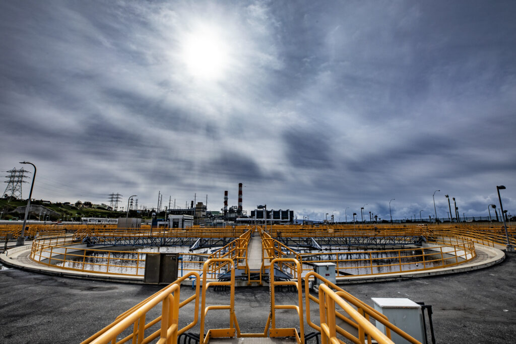
The Hyperion water treatment plant in Los Angeles, whose mayor Mayor Eric Garcetti announced in February 2019 a goal of recycling 100% of the city’s wastewater by 2035.
August 3, 2021 — Editor’s note: This story is part of a four-part series — “Hotter, Drier, Smarter: Managing Western Water in a Changing Climate” — about innovative approaches to water management in the U.S. West and Western tribal nations. The series is supported by The Water Desk, an independent journalism initiative based at the University of Colorado Boulder’s Center for Environmental Journalism. You can read the other stories in the series, along with more drinking water reporting, here.
For decades, water officials in San Diego, realizing the city was facing an ever-drier future, have worked to make the idea of what’s known as “direct potable reuse,” or DPR, more palatable to residents. In the 1990s, that turned into an uphill battle. The technology delivers purified wastewater to customers’ faucets without an environmental buffer — such as a groundwater aquifer, river or other go-between — prior to distribution, so opponents labeled it “toilet-to-tap.” The epithet stuck and torpedoed the Southern California city’s water recycling plans.
But of course the water issues stuck around as well, leaving the city to continue looking for new sources of water, especially those that might be drought proof.
And San Diego is just one city among many in the country’s most arid regions facing the ongoing threat of long-term drought. Western water agencies continue working to not only conserve water, but to also reuse as much wastewater as possible, including from the stable supply DPR promises. As San Diego discovered decades ago, making DPR a reality entails — along with regulatory and permitting changes — trying to overcome the “yuck factor.” Today, despite its “toilet-to-tap” hurdle, San Diego is now intent on becoming the first city in California to convey treated effluent directly from factory to faucet.
“We’re ahead right now, and it looks like we’ll be the first ones out of the gate,” says John Stufflebean, assistant director of the San Diego Public Utilities Department and executive lead for Pure Water San Diego, the name of the city’s latest water reuse project.
Watering the West
While DPR has faced backlash, indirect potable reuse — injecting treated effluent into a buffer such as a groundwater aquifer prior to distribution — has been watering the West for decades.
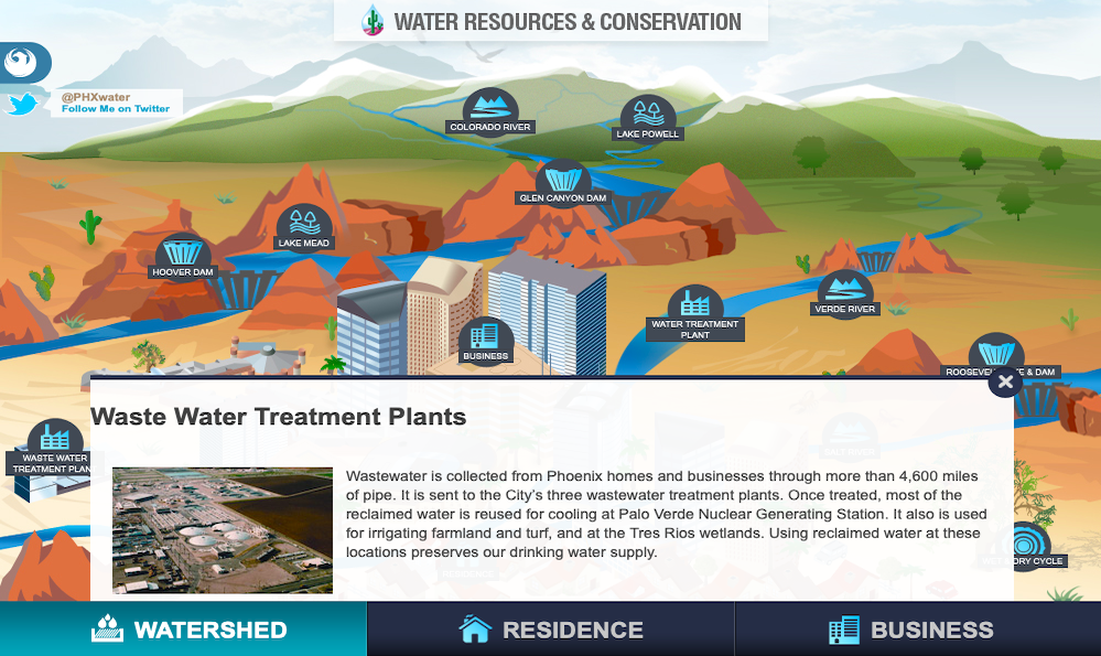
For nearly a century, Phoenix, Arizona, has been a model for water reclamation — and today recycles nearly all of its wastewater for indirect reuse. In addition to contributing water that helps cool the inland Palo Verde Nuclear Power Plant, Phoenix today supplies indirect-treated effluent for agricultural and turf irrigation. But as the Colorado River supply — which still accounts for 40% of Phoenician water — becomes more and more uncertain, officials are looking for new ways to avert a thirsty future.
“We are actually on the cusp of beginning some significant infrastructure investment in the northern part of the city,” says Cynthia Campbell, water resources management advisor for the City of Phoenix.
DPR will be a critical component of that investment, with Phoenix Water, as the city’s Water Services Department is known, planning to revive a dormant wastewater treatment plant built in the late 1990s, according to Campbell. The restored plant would serve customers in the northern part of the city and should be operational within 5 years, she says. The project would involve blending treated effluent with Colorado River water or groundwater before distributing it to customers.
Although this process — known as raw water augmentation — would involve blending the recycled water with another source, it still qualifies as DPR because the mix would head directly into the drinking water treatment plant, from which water flows to customers, as opposed to the necessary additional step indirect potable reuse requires, where the wastewater goes into a groundwater basin or other environmental system before the water can be reclaimed.
Describing the plans as “trailblazing,” Campbell explains that Arizona has signaled its willingness to consider DPR permits on a case-by-case basis, for projects of various scales. This approach is different from that of California, which will first need to approve the relevant regulations on a statewide level before individual projects can move forward.
In addition to contributing water that helps cool the Palo Verde Nuclear Power Plant, Phoenix supplies indirect-treated effluent for agricultural and turf irrigation. Click the image for an interactive graphic about Phoenix’s water resources and conservation efforts from phoenix.gov.
Campbell notes that no one in the U.S. has augmented water in the way Phoenix is planning to. “We’ll probably be the guinea pigs for everyone,” she says.
Meanwhile, she does not foresee any public opposition to the project due to the longstanding Phoenician “culture of conservation.”
“They live in the Sonoran Desert,” she says. “They are under no illusions that there are unlimited sources of water here.”
Nonetheless, Campbell stressed that Phoenix Water wants to ensure that people are comfortable drinking their tap water, and she is therefore determined to show the public that water “that goes down the toilet is not in any way, shape or form what it is when it comes out of a modern, updated, sophisticated treatment system.”
“The Ability to Filter Out Anything”
Campbell looks to Phoenix’s neighbors in nearby Scottsdale as leaders in demonstrating the safety of DPR. In a non-Covid yesteryear, curious Arizonans could venture to Scottsdale’s Advanced Water Treatment Plant to take a sip of treated water or attend the annual Canal Convergence arts festival to sample a beer — all originating from treated effluent.
“Using [the festival] to change public perception was really important and vital,” says David Walby, water reclamation services director for the City of Scottsdale.
Scottsdale was the first recipient of an Arizonan permit for DPR, and one of just a few nationwide. Although the water produced from the initiative doesn’t go into Scottsdale’s drinking water — instead the water will be available for taste testing at the Scottsdale Water Campus and will be provided to beverage companies for water-based beverages, according to the permit — it will be up to drinking water standards. The city acquired that permit after regulations changed in 2018, allowing people to consume highly treated effluent, Walby explains. Unlike Phoenix’s plan, Scottsdale’s DPR pilot doesn’t rely on raw water augmentation. Given the city’s 20-year history of using ultrafiltration, reverse osmosis and advanced oxidation for indirect potable reuse, Walby says that the transition to DPR “wasn’t a big leap” from a technological standpoint.
Campbell says the technology Scottsdale is using has “the ability to filter out anything,” adding that this “type of technology could turn out a quality far better than what we’re seeing in our raw water.”
Once the 2018 regulations were in place, Scottsdale and the Arizona Department of Environmental Quality decided to launch a program to demonstrate the viability of DPR. Their facility serves a maximum of only 1,500 visitors per year and is limited to producing 21,600 gallons (82,000 liters) per day — on a campus where a conventional treatment facility processes 70 million gallons (265 million liters) of water daily, according to Walby. Meanwhile, the Advanced Water Treatment Plant has the capacity to treat up to 20 million gallons per day to quality levels that exceed bottled drinking water standards.
While Scottsdale itself doesn’t have a need for a full-scale DPR water supply, due to its abundant surface water supply from the Central Arizona Project and the Salt River Project, Walby says the site could serve as a proof of concept for “outlying communities in northern Arizona solely dependent on groundwater,” or for utilities from other states.
“The financial component is always the elephant in the room.”
David Walby
Asked if implementing full-scale DPR would become practical any time soon, Walby says that cities must consider both their economic and water quality needs.
“Sometimes, those are on polar opposites,” he says. “From a financial standpoint, it’s not cheap. This stuff is really, really expensive.”
Walby says that while Scottsdale is able to maximize the equipment’s shelf life with careful maintenance, investing in such technology might be less practical for small northern Arizona communities. Suggesting that federal assistance could be one avenue toward solving this predicament, he cautions that using reclaimed water will never offset water demand — for every gallon of treated water he sends out, he only receives about 35% to 40% in return.
“The financial component is always the elephant in the room,” he says.
From “Toilet-to-Tap” to Pure Water
Unlike in Arizona, where permit approval for DPR occurs on a case-by-case basis, water agencies in Southern California are enthusiastically awaiting expected statewide regulations that will enable such projects across the board.
Jennifer West, managing director at the NGO WateReuse California, explains that the California State Legislature passed Assembly Bill 574 in 2017, requiring the State Water Resources Control Board to adopt regulations for DPR by 2023. The recommendation to develop these regulations also appears in Governor Gavin Newsom’s portfolio of water resiliency efforts, she adds.
“I am very optimistic that it can happen in the timeframe of the legislation,” West says. “With climate change, it’s extremely important that agencies diversify their water supply.”
As San Diego attempts to do just that, the city has needed to take a more creative approach toward wastewater reclamation, due to its minimal groundwater supplies. Pure Water San Diego, the city’s major water reuse initiative, will be occurring in multiple steps — a first phase focused on the northern part of the city and involving the use of a reservoir for indirect potable reuse, followed by second and third phases involving DPR, once California’s regulations are active, according to Stufflebean.
Construction recently began on phase 1, in which wastewater will be discharged into a reservoir and only later head to a treatment facility — generating about 30 million gallons (114 million liters) of potable water daily by 2025, according to Stufflebean. This phase qualifies as indirect potable reuse, Stufflebean explains, because the large reservoir provides some dilution and the long retention time allows some natural disinfection to take place, but implementing the plans required a change in regulations that deemed reservoirs an environmental barrier.
Phases 2 and 3 of the project, which will qualify as DPR, will involve injecting much more effluent into a smaller reservoir — too small to be considered a big enough buffer for indirect potable reuse — located upstream from the treatment plant, Stufflebean says. Assuming California’s DPR regulations move forward as expected, he anticipates that the second and third phases will begin supplying water by 2035.
In a city that was once appalled by the idea of DPR water, Stufflebean says most residents seem to be on board two decades later. Stressing the importance of public education on the issue, he points out that San Diegans are now well aware that they are already drinking treated wastewater through indirect injections upstream.
“There are 400 dischargers into the Colorado River and the water from Northern California that is right now the supply of San Diego — including the city of Las Vegas and city of Sacramento.” Stufflebean says. “They discharge their water into our water supply. The Pure [project] water is way cleaner than the Colorado River water.”
Different Water for Different Uses
Another nearby agency working to integrate DPR into its portfolio is West Basin Municipal Water District, according to Barkev Meserlian, the agency’s executive manager of engineering and operations. West Basin provides water to 17 cities and unincorporated areas in Los Angeles County. After the region started experiencing drought in the late 1980s and early 1990s, West Basin set out to build a recycled water system, Meserlian says.
“There was a recognition around southern California that we need to do something to save every drop of potable water that was available,” he says.
But the project leaders recognized that different users required water treated to different standards. These discrepancies turned into an innovative recycling program that now offers five “designer waters,” as the program calls them, to meet diverse customer demands from one central location.
While all those distinct types of water come from indirect reuse projects, Meserlian describes West Basin as “a long proponent of pursuing DPR,” acknowledging that regulating the process will involve certain technical challenges such as defining what it would take to ensure that DPR passes safe drinking water regulations. He expresses optimism, however, that, with the passage of Assembly Bill 574 and Governor Newsom’s water resiliency portfolio, Californian officials will adopt plans soon, focusing on raw water augmentation.
“A Very Clever Project”
One such project, the city of Los Angeles’s US$8 billion Operation NEXT, intends to recycle 100% of the water generated by the Hyperion Water Reclamation Plant — as much as 217 million gallons (821 million liters) per day — for beneficial reuse by 2035. The project directors are planning both indirect and direct reuse projects by replenishing the West Coast, Central and San Fernando groundwater basins with the purified water, as well as eventually injecting it directly into the Los Angeles Aqueduct Filtration Plant, a plant that treats 60-70% of the city’s water supply.
“We’re going to tilt the city of Los Angeles on its side and have water flow about 1,200 feet [366 meters] up to the headwaters at that filtration plant,” says Richard Harasick, the senior assistant general manager of the Water System for the Los Angeles Department of Water and Power (LADWP). From there, according to Harasick, because the treated effluent would be blended with raw water at the headwaters of the filtration plant, all residents would be receiving the same water — rather than some getting this water and others receiving surface water, as will occur in Phoenix.
Because of this, Campbell, from Phoenix Water, says she considers the Los Angeles plans to be “a very clever project.” She continues: “Everybody is effectively getting the same thing. … Having that blending, for some, takes away the yuck factor.”
“When this is done, along with our complete local resource portfolio, I’d like to say that the words ‘drought’ and ‘Los Angeles’ will never be in the same sentence again.”
Richard Harasick
Operation Next will first and foremost be a water supply program, as the city of Los Angeles has determined that relying on imported water is no longer a sustainable strategy, according to Harasick. Although he says that Los Angeles has reduced consumption from 700,000 acre-feet (863 million cubic meters; one acre-foot is about 326,000 gallons) to 500,000 acre-feet (617 million cubic meters) annually in the past 30 years, while increasing its population by 1 million, Harasick stresses the importance of generating a local source in order to continue managing demand.
As far as public understanding in Los Angeles is concerned, Harasick says that the city has been laying the groundwork for 20 years and also credited nearby Orange County for providing a positive example. Orange County has been using reverse osmosis to treat wastewater since the 1970s and now manages a groundwater basin that supplies 70% of the water supply to its 2.5 million people, according to Mike Markus, Orange County Water District general manager.
Although Orange County doesn’t have any DPR projects, “they’ve really plowed the ground for public acceptance,” Harasick says, because the municipality was responsible for implementing indirect reuse in the region on such a massive scale — a step that likely had to occur before anyone would be OK with DPR. Harasick adds that Los Angeles will be purifying its water to the same standards as those of Orange County.
Expressing similar confidence that direct potable reuse “is on the horizon,” Markus agrees that Los Angeles and San Diego would be ideal candidates for such ventures. Orange County, on the other hand, does not have the same need, Markus notes, due to the capacity of its large groundwater basin — the coastal aquifer — to store treated wastewater from the Orange County Sanitation District.
“For those that don’t have a groundwater basin or a reservoir, direct potable [reuse] is a key to opening up that additional [water] recycling,” Markus says.
In the short term, Markus continues, the most realistic — and more palatable — form of direct potable reuse will be raw water augmentation, similar to Los Angeles’ plans.
“When this is done,” Harasick adds, “along with our complete local resource portfolio, I’d like to say that the words ‘drought’ and ‘Los Angeles’ will never be in the same sentence again” — a desire shared by water managers across the U.S. West, as they look for more ways to secure their water supplies against an uncertain future.
The Water Desk’s mission is to increase the volume, depth and power of journalism connected to Western water issues. We’re an initiative of the Center for Environmental Journalism at the University of Colorado Boulder. The Water Desk launched in April 2019 with support from the Walton Family Foundation. We maintain a strict editorial firewall between our funders and our journalism.
Thanks to a major infusion of COVID-related state stimulus cash earlier this year, nearly $13 million in grants was awarded by the Colorado Water Conservation Board on Sept. 16 to projects designed to improve irrigation systems, aid the environment, improve water storage, and reconnect a critical channel on the Colorado River in Grand County.
The Colorado Water Conservation Board (CWCB) has historically dispensed $7.5 million annually in grants to assist projects that align with the goals of the 2015 Colorado Water Plan.
Thanks to the state stimulus funding, state legislators delivered $15 million in cash to the grant program, more than double last year’s amount. The funds must be awarded by July 2023.
In addition to supporting the water plan, the grants are designed to benefit multiple segments of the state’s economy, according to Anna Mauss, the CWCB’s chief financial officer.
“That can be hard to define,” she says, “but we are looking at solutions that benefit all sectors.”
Environment and recreation projects represented the largest slice of the pie at $6.6 million. The second largest slice, at $4.2 million, went to water storage and supply projects. Four agriculture projects together got $1.5 million.
The largest recipient of grants funds, at $3.8 million, is the Windy Gap Dam bypass, a project that will reconnect a critical channel on the Colorado River in Grand County. It has federal, state and county funding and cash from conservation organizations and landowners, all working under the umbrella of the Northern Water Conservancy District, which owns Windy Gap.
The dam was constructed in the 1980s just below the confluence of the Fraser with the Colorado River west of Granby. Aquatic life has since diminished. The new channel is to reconnect the Colorado downstream from the dam with its upstream habitat.
According to the application, the project will expand the river’s gold medal trout fishery and make this segment more resilient in the face of increased water diversions, wildfires and climate change.
The Colorado Department of Agriculture got nearly $300,000 for a soil health project that will focus on the Republican River watershed for three years. Program directors expect 10 farmers to participate, incorporating water-saving actions into their land-use planning in a way that will conserve 47,000 acre-feet annually. In this way, according to the grant application, the project will also help sustain the Ogallala Aquifer.
Two other projects getting funding are on the Front Range. At Barr Lake, located along Interstate 76 northeast of Denver, the Farmers Reservoir and Irrigation Co. plans to enlarge the storage capacity. A new study of regional extreme precipitation by the Colorado Dam Safety found that raising the spillway culvert would safely accommodate 1,500 acre-feet of additional storage. This, however, will inundate structures in the surrounding state park. The $279,000 granted the company will provide partial funding to mitigate the higher water levels on the park facilities.
Trout Unlimited was awarded $300,000 for efforts to restore populations of the greenback cutthroat trout, Colorado’s state fish, at the headwaters of the Cache la Poudre River. The species is native to the Eastern Slope, but the Poudre is augmented by diversions from the headwaters of the Colorado River in Rocky Mountain National Park. Most prominent of those diversions is the Grand River Ditch. The $300,000 granted to Trout Unlimited will go to creating a fish barrier in the Grand Ditch where it flows across the Continental Divide and into a tributary of the Poudre River.
David Nickum, executive director of Colorado Trout Unlimited, said that the project will take about 10 years. The greenback is currently federally listed as threatened by the Environmental Protection Agency, but Trout Unlimited hopes that a recovery stronghold on the Poudre can result in delisting. The full project will provide connected habitat for the trout species to more than 38 miles of stream and more than 110 acres of lakes and reservoirs.
Correction: An earlier version of this article incorrectly identified the owner of Windy Gap Reservoir.
Long-time Colorado journalist Allen Best publishes Big Pivots, an e-magazine that covers energy and other transitions in Colorado. He can be reached at allen@bigpivots.com and allen.best@comcast.net.
Fresh Water News is an independent, nonpartisan news initiative of Water Education Colorado. WEco is funded by multiple donors. Our editorial policy and donor list can be viewed at wateredco.org.
The Water Desk’s mission is to increase the volume, depth and power of journalism connected to Western water issues. We’re an initiative of the Center for Environmental Journalism at the University of Colorado Boulder. The Water Desk launched in April 2019 with support from the Walton Family Foundation. We maintain a strict editorial firewall between our funders and our journalism.