
By Catherine Lutz
Brian Lazar clearly remembers his personal “‘holy crap’ moment” of the March 2019 avalanche cycle.
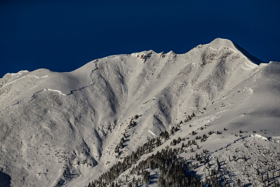
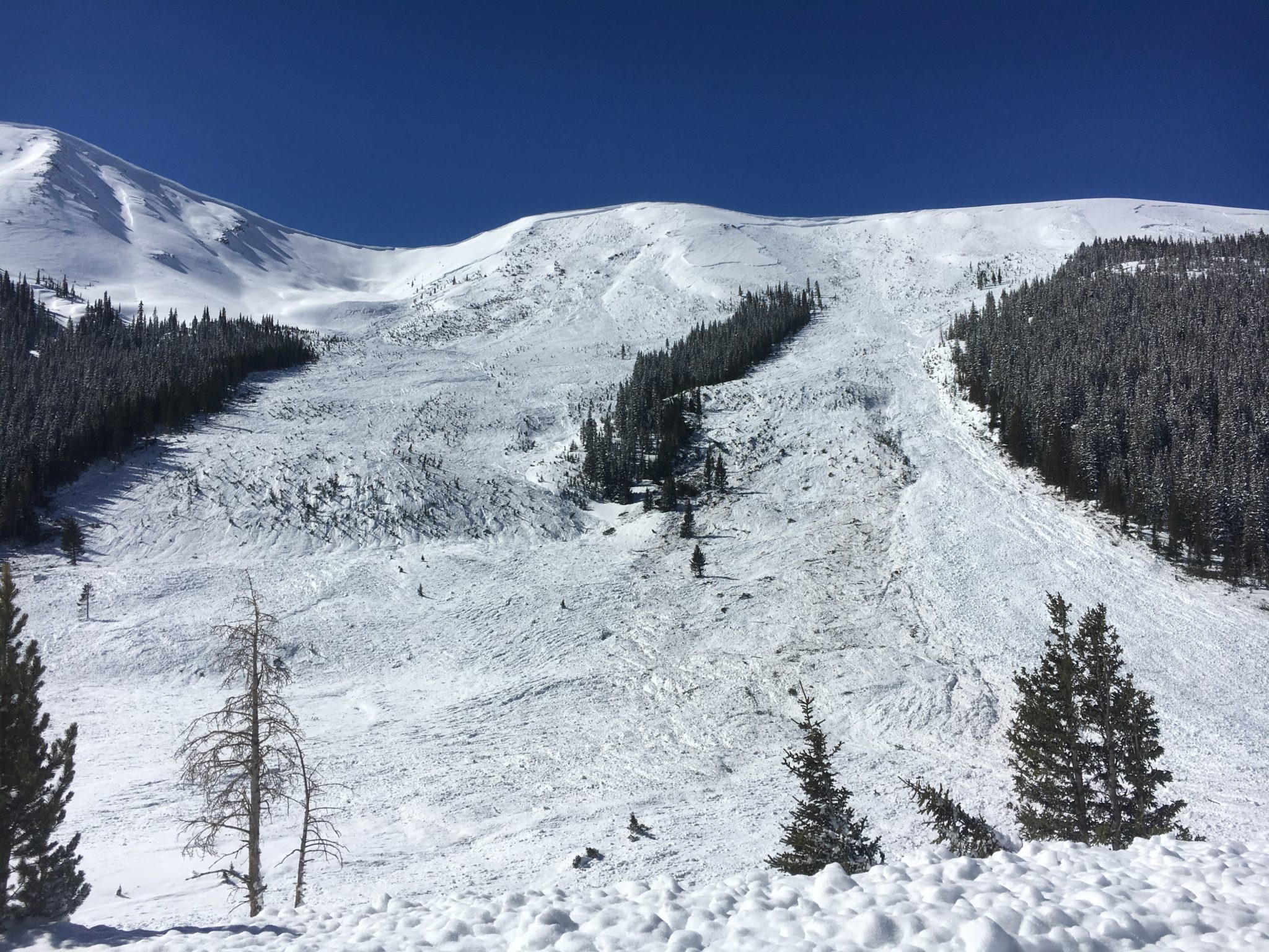
Early last March 9, the deputy director of the Colorado Avalanche Information Center stood atop Highland Peak and saw that the entire Highlands Ridge, which stretches behind Highland Peak and includes popular backcountry skiing areas such as Five Fingers and the K Chutes, had slid. It was the largest avalanche he had ever seen in Colorado.
The avalanche had broken naturally sometime overnight, with a crown later estimated to be nearly two miles wide. It ran more than 3,000 feet downhill, funneling into Conundrum Creek Valley with such momentum that after filling the creek, it traveled 300 feet up the other side. The force took out “hundreds if not thousands of trees,” according to Lazar’s report, and damaged an unoccupied home that was saved from obliteration by a concrete wedge built for exactly that reason.
Along with his 19 CAIC colleagues, Lazar was experiencing the most intense two weeks of his career — dealing daily with forecasting, public-safety concerns and threats to infrastructure as storm after storm delivered unprecedented amounts of heavy, wet snow across the state.
“Almost every corner of the state was producing historic-sized avalanches, so it was all hands on deck,” said Lazar. “No one slept for about two weeks.”
Early in the cycle, Lazar had watched the storms rolling in from the West Coast. He recalled seeing “a shocking, amazing amount of water coming our way” — borne on atmospheric rivers, which are narrow streams of concentrated water vapor in the sky — and thinking it was time to elevate avalanche danger to “extreme” due to anticipated snow loading.
Last March 7, CAIC issued the extreme warning — a 5 (on a scale of 1-5), which recommends avoiding all backcountry terrain — in four of its 10 backcountry zones, including Aspen, for the first time in its history.
Two days later, Lazar was in Aspen to help local officials deal with concerns about municipal water supplies being cut off by slides (which they were not), when he witnessed the Conundrum avalanche.

The Conundrum avalanche would be classified a D5 on the five-level D (for destructive) scale, meaning it’s among the largest avalanches known and can “gouge the landscape.” This slide and two others, including one that scoured Garrett Peak up East Snowmass Creek on March 14, were the first in Colorado history to be classified as D5s.
According to Lazar, about 1,000 avalanches statewide were reported to CAIC during the first two weeks of last March. Of those, 87 were categorized as D4 or larger. By comparison, 24 avalanches classified D4 or larger were reported statewide from 2010 through 2018. Further analysis of CAIC’s avalanche database, which starts in November 2010, shows that 12 of the 15 observed D4-plus avalanches in the Aspen zone ran last March.
Although the 2019 slides claimed no lives in the Roaring Fork River valley, eight people across the state were killed and a record 136 people were caught in avalanches last winter.
Avalanche experts agree that what happened in Colorado last winter — and across much of the west — was unusual, with some suggesting that kind of widespread, large-scale avalanche activity hasn’t been seen for well over a century.
In studying what led to this avalanche cycle, snow scientists are identifying some elements — such as warmer temperatures, wetter air and snow, and more-intense storms — that are not so unusual and are consistent with a warming climate. Experts are careful to distinguish weather and climate, especially when it comes to individual weather events, but there are links between the two.
“Avalanches are weather-driven phenomena, so if there’s changes in the weather — big or little — it will affect avalanche cycles,” said CAIC director Ethan Greene, a snow scientist. “I don’t think there’s a question that avalanche cycles are affected by changes in climate. It’s more a question of how.”
Anatomy of a cycle
Greene breaks down the March 2019 cycle into three phases. First, early-season snowfall in October formed a weak base layer. Early snow is not unusual, but the fact that it stuck on all aspects was, he said.
The second event was consistent snowfall through midwinter, which Greene considered somewhat unusual because there were no extended dry periods or large-enough storms to slough off the upper layers of the snowpack.
Then came the atmospheric-river succession of warm storms, during which some weather sites recorded the highest 24-hour precipitation totals in their history, according to Greene. The season’s strong snowpack, atop a thin unstable base, couldn’t withstand the weight of the new snow, particularly with its high water content. Avalanches ran long, with huge fracture lines, on all aspects. The fractures from the Conundrum slide were so energetic that they propagated deep into the underlying snowpack, setting loose massive volumes of snow.
“What’s unusual about what happened in March was the magnitude of some of these events and their successive nature — a two-week period with all those events, that’s very unusual,” said Greene.
CAIC is teaming up with the U.S. Forest Service, U.S. Geological Survey and Montana State University to study the March 2019 cycle. Through the Colorado Big Avalanche Project, a study of tree rings collected last summer, snow-science professionals are researching the likelihood of such a cycle happening again and how climate change affects snowpack and avalanches.
What the science says
In the U.S., there hasn’t been much scientific study of the link between climate change and avalanche activity, but there has been work on elements seen in the 2019 avalanche cycle.
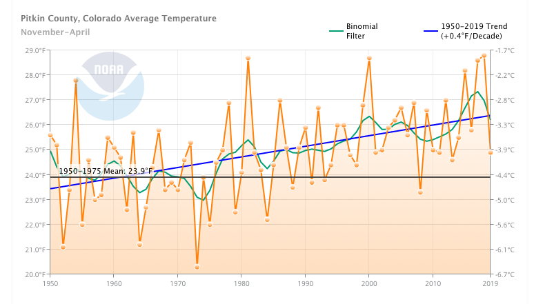
One trend that’s crystal clear is that winter temperatures are rising. Winters in Pitkin County are nearly 3 degrees Fahrenheit warmer on average than they were during the 1950-75 baseline period. And March is the fastest-warming month — with temperatures rising just under 1 degree per decade.
Temperatures are expected to continue rising into the future, although by how much depends on greenhouse gas emissions. A 2008 study co-authored by Lazar (before his CAIC tenure) predicts that Aspen will warm around 3.6 degrees by 2030 and nearly 9 degrees by 2100.
Lazar’s study, done for the Aspen Skiing Company, concluded that wet snow avalanches are likely to occur earlier in future winters on Aspen Mountain — in some scenarios, during the operating season instead of after the lifts close. This will pose a new operational challenge for future ski-area managers, he noted.
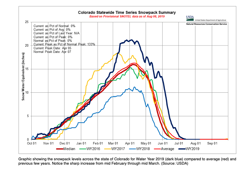
A related impact on snow and avalanche activity is snow-water equivalent, or SWE, which is the amount of water in snow and is a standard measure of snowpack. Seasonally, low snowpacks can lead to dry soil, drought and wildfire conditions, while high season-long SWE can produce high stream runoffs, healthy water supplies and more stable snowpacks.
A dramatic increase in SWE in a short period of time can overstress the snowpack and produce large avalanches, as it did last March. For example, on April 1 Independence Pass measured its highest snowpack since 1984; but it wasn’t trending that way until the early March storms added several inches of SWE.
Snow science professionals also watched SWE numbers rising rapidly, and observations confirmed that the snowfall from the storms was unusual.
“From a field practitioner perspective,” said Greene, “there were certain parts of the state where the snow just felt different — a little moister, clinging to places in a certain way.”
Chris Wilbur, an engineer and alpine natural-hazards expert based in Durango, has observed and documented warmer winter storms over the past two decades. The snow-loading of March 2019, he wrote in The Avalanche Review recently, was “not inconsistent with climatic trends of warmer and wetter air masses colliding with our mountains.”
Wilbur in 2018 surveyed 240 experienced avalanche practitioners across North America on the impacts of climate change on avalanches. Respondents across all regions both observed and predicted more wet avalanches, more avalanches at higher elevations and, in general, increases in snowpack stability due to wetter, denser snow.
In a phone conversation, Wilbur explained that some of the increased activity will likely be driven by warmer, more extreme storms — such as those in March 2019 — which hold more energy and thus deliver lots of precipitation and wind. Avalanches at higher elevations, which in Colorado is usually above treeline, are likely to be bigger and more destructive. On the other hand, Wilbur and other experts foresee fewer avalanches at lower elevations, where there will be less snow.
“We’re in the early stages of seeing changes, though in my observations, mostly through the literature, the potential effects of climate change on avalanches might be accelerating. That’s just my opinion,” Wilbur said. “The wild card is the variability that comes with climate change.”
Scientific study of climate and avalanches seems more robust in Europe and in the Himalayas. A 2013 study in the Swiss Alps found more wet snow and “glide” avalanches (ones where the entire snow cover runs on smooth ground) happening in midwinter, coinciding with rising temperatures.
In the French Alps, a 2014 study predicted increasing wet avalanche activity at high elevations earlier in the winter season, along with fewer avalanches at lower elevations and in springtime. By the end of the 21st century, however, snowpacks will be getting thinner even at high elevations, reducing avalanche danger.
Using 150 years of tree ring records, researchers in the Indian Himalayas found that a warming climate is producing more and more destructive wet-snow avalanches in winter and early spring.
The human factor
Overall, a wetter, more stable snowpack is good news for backcountry travelers.
“I’ve definitely noticed that the snow is denser and thicker on average,” said Lou Dawson, founder of WildSnow.com and a local backcountry skier for more than 40 years. “More and wetter Colorado snow as a rule make for safer backcountry.”
But a 2017 study linking atmospheric river events and avalanche deaths suggests that atmospheric rivers are more dangerous for a continental snowpack such as Colorado’s, which is weaker than coastal snowpacks and less able to handle heavy snow-loading.
“Large, late-season storms may lead to decreased snow stability during a time of year previously characterized by increased stability,” the authors of the study wrote in the Journal of Hydrometeorology. “With increasing numbers of recreational backcountry users and changing mountain snowpack conditions, we might expect the future to be characterized by enhanced exposure to avalanche hazard throughout the (western U.S.).”
Dawson argues that high avalanche danger associated with storms like those last March mostly deters people from venturing into the backcountry.
“I was just another backcountry person sitting in Carbondale knowing I couldn’t go anywhere,” he said.
Three of the eight fatalities during the 2018-19 season occurred during the March storm cycle; two of those three were backcountry skiers. Overall, a record 135 people were caught in 92 avalanches — numbers that correspond more to the sheer volume of avalanche activity than any one type of storm.
Last winter’s avalanche cycle also wreaked havoc on homes and infrastructure. Roads and highways closed around the state, and Castle Creek Road was buried by an avalanche that also interrupted power service to some homes.
Eight homes were destroyed or damaged during the March storm cycle, including the Conundrum Creek home with the protective avalanche wedge.
Civil engineer Art Mears, who works with homeowners and governments across the west to mitigate natural hazards, said that the Aspen Snowmass area is not unique in avalanche threats to its built environment. While local building codes consider 100-year avalanches, Mears thinks they should consider 300-year avalanches.
Unpredictability is something avalanche professionals deal with daily, but the increasing variability of weather events in light of climate change adds another challenge.
Although nobody expects to see another avalanche cycle like last winter’s anytime soon, Greene and his team have been surprised to see several similarities this season: a similar weak base layer, progressively strong snowpack and an atmospheric-river event in early February that “produced some interesting avalanche activity,” said Greene. “We saw some 50-year events.”
“There are 50 knobs that affect avalanche conditions, and it’s not the setting of each of those knobs, it’s cumulative,” Greene concluded. “We have to understand how they all come together and affect avalanche activity. What I can say is that climate change will make things more complicated.”
This story was published by Aspen Journalism on March 9, 2020. Aspen Journalism collaborates with The Aspen Times and Aspen Public Radio on coverage of the environment and climate change. A version of this story ran in the The Aspen Times and a conversation about the story aired on APR on March 9.
This story was supported by The Water Desk.
The Water Desk’s mission is to increase the volume, depth and power of journalism connected to Western water issues. We’re an initiative of the Center for Environmental Journalism at the University of Colorado Boulder. The Water Desk launched in April 2019 with support from the Walton Family Foundation. We maintain a strict editorial firewall between our funders and our journalism. The Water Desk is seeking additional funding to build and sustain the initiative. Click here to donate.


