As climate change and drought continue to sap streams and rivers, the U.S. Bureau of Reclamation is offering $500,000 to anyone 18 years old and older worldwide who can produce a better tool to measure how much water snowflakes contain.
“Our technology must advance to meet the particular challenges of climate change and extreme weather,” said Greg Lipstein, a principal at DrivenData, one of the firms partnering with Reclamation and NASA to conduct the challenge.
The high-tech challenge comes as Colorado and other Western states are experiencing a shockingly dry fall and early winter. Denver, for instance, broke the record for the latest first snow in November and is still seeing little if any of the white stuff.
And the seven-state Colorado River system is struggling as well, with lakes Powell and Mead hitting record lows this year and little relief in sight.
Cities and farms across much of the West rely primarily on mountain snowmelt for their water supplies. While periodic drought has always been part of the West’s water story, before the region became highly populated, in most years there was enough water to serve the people who relied on it. But as climate change has triggered decades-long megadroughts, and populations have soared, water is becoming an ever-increasingly scarce resource.
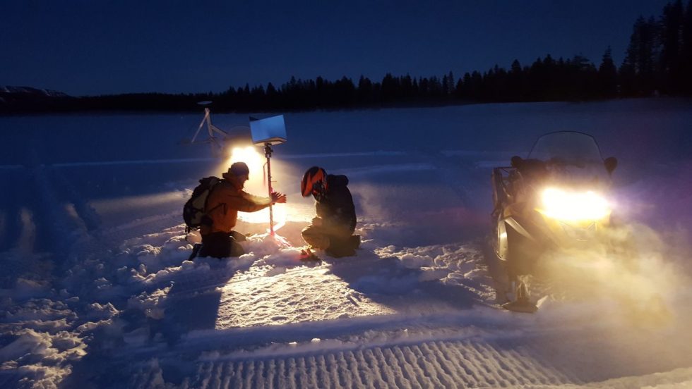
In the world of snow forecasting, it’s important to be able to know early how snowy a winter season is likely to be, and even more important to know how much water is contained in the snow that falls. Flakes that come down in ultra-cold weather can contain much less water than those that fall during warm spring storms.
To bring more certainty to efforts to forecast and therefore manage snow-based water supplies, the Reclamation has partnered with three technology companies to challenge anyone older than 18 to develop a tool that can predict snow water content, also known as snow water equivalency, with greater accuracy. Reclamation is the largest water supplier in the West and operates major reservoirs such as lakes Powell and Mead.
During the winter of 2020-21, ultra-dry soils absorbed melting mountain snowpacks that in some areas were about average. As a result, the melting snow generated just 30% of what had been forecast in some areas on Colorado’s Western Slope and in California and elsewhere.
Traditionally, the federal government has used ground-based tools known as “SNOTEL” sites, short for snow telemetry, to measure the snow as it accumulates. In Colorado, for instance, the U.S. Natural Resources Conservation Service (NRCS) maintains and monitors more than 150 sites across several states, many of them in remote mountain regions. But the SNOTEL sites are limited in the amount of data they can produce.
New technologies are also being tested, such as airplane-based LiDAR systems in which flyovers are conducted to monitor large swaths of mountain terrain using gear that can detect snow depth and water content. This new tool can generate thousands of data points, but the flyovers cost hundreds of thousands of dollars, according to NASA.
The airborne technology is already being used in Colorado and California by large utilities who are willing to foot the bill.
Satellite imagery is also being used, but it too has limits, according to Karl Wetlaufer, a Colorado hydrologist with the NRCS. Some satellite services can provide daily reports with what he calls “coarse” data that doesn’t provide enough detail for scientists and modelers.
Other satellite platforms provide finer data, but might only do so every 16 days, too infrequently to deliver the precision water managers need, Wetlaufer said.
“Over the last several years there has been a lot of emphasis on getting snow water equivalency data. Agencies like NASA are good at attacking it from a research standpoint, but this competition is going to take a lot of NASA’s research and actually come up with a near real-time operational model blending microwave, radar, airborne snow observatory, and SNOTEL.
“This push by Reclamation is a big boost to putting this research into an operational model that can be used day to day,” Wetlaufer said. “I think it’s a really awesome concept that could be potentially valuable to the community.”
The contest launches this week and will continue through July 2022, according to Reclamation.
The Water Desk’s mission is to increase the volume, depth and power of journalism connected to Western water issues. We’re an initiative of the Center for Environmental Journalism at the University of Colorado Boulder. The Water Desk launched in April 2019 with support from the Walton Family Foundation. We maintain a strict editorial firewall between our funders and our journalism.
Lake Powell, created with the 1963 completion of Glen Canyon Dam, is the upper basin’s largest reservoir on the Colorado River. But 2000-2019 has provided the least amount of inflow into the reservoir, making it the lowest 20-year period since the dam was built, as evidenced by the “bathtub ring” and dry land edging the reservoir, which was underwater in the past. Credit: EcoFlight
Los Angeles is creating wetland parks in low-income neighborhoods, and using them to help clean polluted runoff.
Seattle has begun a mobile wastewater collection program to gather gray and black water from RVs and improve the city’s water quality, which had begun to deteriorate as the homeless population grew and wastewater spills from campers became more common.
Las Vegas has structured its water rates to encourage people to conserve while ensuring that low-income households have access to affordable, clean water.
“We’re facing challenging times,” said Adel Hagekhalil, general manager of the Metropolitan Water District of California, the largest water utility in the United States. His comments came Nov. 3 at the Water in the West Symposium in Denver, a conference sponsored by Colorado State University and Denver Water.
“We’re facing drier days, hotter days and shrinking water supplies across our region. We need new chapters in our playbook,” Hagekhalil said.
Hagekhalil was among several Western water utility leaders who said efforts to address shrinking water supplies due to drought and population growth means utilities will have to change dramatically in the next 50 to 100 years.
MWD, for instance, has always imported water to distribute to a service area that includes some 20 million people. But now the agency is looking for ways to increase local supplies as its Colorado River supplies shrink.
The answer, in part, is a sophisticated effort to capture the region’s sometimes copious rainfall and inject it into aquifers, where space is plentiful. The utility is also creating urban wetland parks where former parking lots stood and providing subsidies to help low-income homeowners repair unsafe and leaking water delivery pipes.
“It’s no longer enough for us to be an importer of water,” Hagekhalil, said. “We need to leverage resources to create more local water and to collaborate across our region to store our groundwater.”
In Seattle, a water-rich city, the challenges lie in soaring water treatment costs and a growing population base that includes a significant number of campers and RV dwellers, driven out of traditional housing because of rising prices.
“Like everyone else, we are trying to change the way we do business,” said Andrew Lee, interim general manager of Seattle Public Utilities.
After watching the number of wastewater spills rise almost as quickly as housing prices, the utility decided to create a mobile collection program for people who had no other way to dispose of their sewage.
“It’s been a game changer and a life changer for a number of people,” Lee said.
Western utilities are spending millions of dollars to build water recycling plants and new storage systems and to upgrade water treatment systems. At the same time, the call for more affordable water is growing as well.
To address the issue Las Vegas provides a 50% subsidy on the first 5,000 gallons of residential water used and charges service fees based on the size of the delivery pipe. Smaller homes pay just $5 a month, while the area’s largest homes pay a service fee of $300, according to John Entsminger, general manager of the Southern Nevada Water Authority, which serves Las Vegas and the surrounding area.
“We need our water prices to send a conservation signal to the high water users,” Entsminger said.
“But we want lower water users to have affordable water.”
To that end, the utility charges customers just $1.74 per thousand gallons for low levels of use.
“That’s how we attempt to make sure that the disadvantaged parts of our community and the poorest parts of it still have access to clean, cheap water supplies for necessary uses,” Entsminger said.
And to help the region address ongoing water shortages, Nevada lawmakers this year made it illegal to use any precious Colorado River water on “non-essential turf.”
But more work lies ahead and the utility leaders said the answers would be found in better integrated water systems capable of addressing supply and affordability issues.
Jerd Smith is editor of Fresh Water News. She can be reached at 720-398-6474, via email at jerd@wateredco.org or @jerd_smith.
Fresh Water News is an independent, nonpartisan news initiative of Water Education Colorado. WEco is funded by multiple donors. Our editorial policy and donor list can be viewed at wateredco.org.
The Water Desk’s mission is to increase the volume, depth and power of journalism connected to Western water issues. We’re an initiative of the Center for Environmental Journalism at the University of Colorado Boulder. The Water Desk launched in April 2019 with support from the Walton Family Foundation. We maintain a strict editorial firewall between our funders and our journalism.
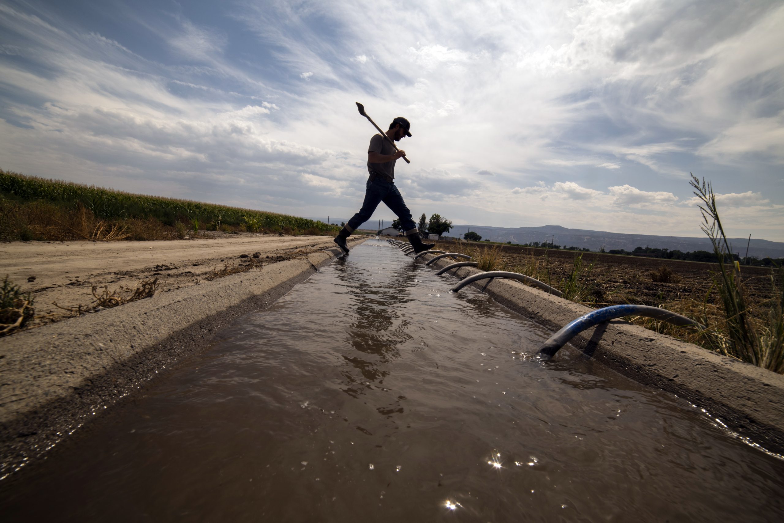
by Larry Morandi A center pivot irrigates a field in the San Luis Valley, where the state is warning farmers that a well-shutdown could come much sooner than expected. Credit: Jerd Smith
The Colorado General Assembly’s interim Water Resources Review Committee is recommending new legislation that, if approved, could set aside millions to help water-strapped regions of the state meet their obligations to deliver water to Kansas, New Mexico and Texas.
It also recommended another bill designed to curb water speculation. Both measures are expected to be considered by the Colorado General Assembly next year.
Groundwater compact compliance
The committee on Oct. 27 approved a draft bill that creates a Groundwater Compact Compliance and Sustainability Fund to help pay for the purchase and retirement of farm wells and irrigated acreage in the Republican and Rio Grande river basins. The action was taken to reduce groundwater use that diminishes surface flows and ensure compliance with interstate compacts on both rivers. Legislative appropriations and federal revenue would bankroll the fund. The Colorado Water Conservation Board would distribute the money based on recommendations from the Republican River Water Conservation District and the Rio Grande Water Conservation District, with approval by the state engineer.
So how much land are we talking about? To comply with compact water delivery obligations and groundwater sustainability rules, 25,000 acres of irrigated land would have to be retired in the Republican basin and 40,000 acres in the Rio Grande basin by 2029. To date, just 3,000 acres in the Republican and 13,000 acres in the Rio Grande have been retired from production. Absent those reductions, well pumping could be curtailed.
When asked how much money is needed, Sen. Jerry Sonnenberg, R-Sterling, whose district includes the Republican River basin, said the conservation district there is looking for $50 million in addition to the $50 million it already has. Pinning the cost down is difficult; Sonnenberg noted that, “It’s harder to retire farm ground when you have $5 [per bushel] corn than it is when you have $3 corn.”
David Robbins, general counsel to both the Republican and Rio Grande districts, testified at an earlier committee meeting that the Rio Grande would also require at least $50 million on top of the $69 million it has already raised by taxing its farmers for sustainability efforts.
Water speculation
The committee also reported a bill that it views more as a vehicle for further discussion than a finished product. It prohibits the purchaser of a water right from engaging in “investment water speculation” and empowers the state engineer to investigate alleged violations. Investment water speculation is defined as “the purchase of agricultural water rights that are represented by shares in a mutual ditch company in the state with the intent…to profit from the increase in the water’s value in a subsequent transaction…or by receiving payment from another person for nonuse of all or a portion of the water” unless it’s part of a water conservation or instream flow program.
Committee members struggled with trying to balance concerns over speculation with protecting property rights. Sen. Kerry Donovan, D-Vail, committee chair and one of the bill’s sponsors, said she continues to hear from constituents on the West Slope about what looks like investment water speculation and its impact on farming operations. At the same time, she noted other groups are sending “a very conflicting narrative now that we actually have bills to respond to…and the feedback is don’t do anything, slow down.”
Sen. Don Coram, R-Montrose, another bill sponsor, emphasized that “it’s not our intent to take away the ability of a farmer whose 401K is his water [if that water were sold], but somehow we need to put some constraints” on speculative investments. “This bill as written,” he continued, “probably doesn’t get us there, but it does give us the opportunity to work through the session.”
With that said, Coram proposed an amendment that broadened the bill’s title by shortening it, from a bill “Concerning a Prohibition Against Engaging in Investment Water Speculation in the State” to one “Concerning Water Speculation in the State.” That change provides the bill sponsors with flexibility to flesh it out over the coming months without being locked in to the current text.
Water infrastructure investment
The committee also approved a letter to the state’s Task Force on Economic Relief and Recovery Cash Fund to consider investing money in water projects. The task force was created by the General Assembly last session to receive federal dollars from the American Rescue Plan Act of 2021 and recommend how to spend it. The legislature transferred nearly $850 million into the fund and among the eligible uses are “investment in water, sewer, or broadband infrastructure.”
The legislature convenes Jan.12.
Correction: An earlier version of this article misstated the date the committee met to approve the draft legislation.
Larry Morandi was formerly director of State Policy Research with the National Conference of State Legislatures in Denver, and is a frequent contributor to Fresh Water News. He can be reached at larrymorandi@comcast.net.
Fresh Water News is an independent, nonpartisan news initiative of Water Education Colorado. WEco is funded by multiple donors. Our editorial policy and donor list can be viewed at wateredco.org.
The Water Desk’s mission is to increase the volume, depth and power of journalism connected to Western water issues. We’re an initiative of the Center for Environmental Journalism at the University of Colorado Boulder. The Water Desk launched in April 2019 with support from the Walton Family Foundation. We maintain a strict editorial firewall between our funders and our journalism.
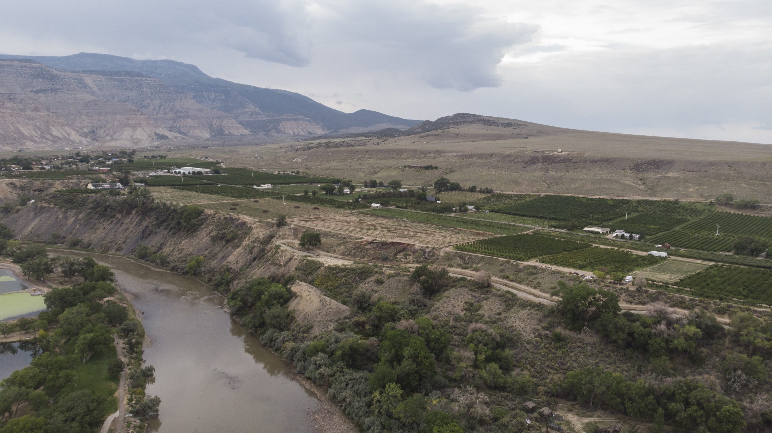
The 96-degree heat has barely broken early on a September evening near Fruita, Colo. As the sun prepares to set, the ailing Colorado River moves thick and quiet next to Interstate 70, crawling across the Utah state line as it prepares to deliver billions of gallons of water to Lake Powell, 320 miles south.
This summer the river has been badly depleted—again—by a drought year whose spring runoff was so meager it left water managers here in Western Colorado stunned. As a result Lake Powell is just one-third full and its hydropower plants could cease operating as soon as July of 2022, according to the U.S. Bureau of Reclamation.
“We’re looking at a very serious situation from Denver all the way to California and the Sea of Cortez,” said Ken Neubecker, an environmental consultant who has been working on the river’s issues for some 30 years. “I’ve never seen it in a worse state.”
The Colorado River Basin is made up of seven states. Colorado, Wyoming, Utah and New Mexico comprise the upper basin and are responsible for keeping Lake Powell full.
Arizona, California and Nevada comprise the lower basin and rely on Powell’s larger, downstream sister reservoir, Lake Mead, just outside Las Vegas, to store water for delivery to Las Vegas, Phoenix, Los Angeles and more than 1 million acres of farmland.
These are two of the largest reservoirs in the United States. Few believed Mead, built in the 1930s, and Powell, built in the 1960s when the American West had just begun a 50-year growth spurt, would face a future where they were in seeming freefall. The two reservoirs were last full in 2000. Two years ago they dropped to 50% of capacity. Now they are operating at just over one-third their original 51 million-acre-foot combined capacity.
First-ever drought accord
Two years ago, this unprecedented megadrought prompted all seven states to agree, for the first time, to a dual drought contingency plan—one for the upper basin and one for the lower. In the lower basin, a specific set of water cutbacks, all tied to reservoir levels in Mead, were put in place. As levels falls, water cutbacks rise.
Those cutbacks began this year in Arizona.
But in the upper basin, though the states agreed to their own drought contingency plan, they still haven’t agreed on the biggest, most controversial of the plan’s elements: setting aside up to 500,000 acre-feet of water in a special, protected drought pool in Lake Powell. Under the terms of the agreement, the water would not have to be released to lower basin states under existing rules for balancing the contents of Powell and Mead, but would remain in Powell, helping to keep hydropower operations going and protecting the upper basin from losing access to river water if they fail to meet their obligations to Arizona, Nevada and California.
Rancher Bryan Bernal irrigates a field that depends on Colorado River water near Loma, Colo. Credit: William Woody
The pool was considered a political breakthrough when it was approved, something to which the lower basin states had never previously agreed.
“It was a complete reversal by the lower basin,” said Melinda Kassen, a retired water attorney who formerly monitored Colorado River issues for the Theodore Roosevelt Conservation Partnership.
But the idea was controversial among some powerful upper basin agricultural interests. Ranchers, who use some 80% of the river’s water, feared they would lose too much control of their own water supplies.
Seeking volunteers
As proposed, the drought pool would be filled voluntarily, largely by farmers and ranchers, who would be paid to temporarily dry up their hay meadows and corn fields, allowing the saved water to flow down to Powell.
Two years ago, when the drought contingency plan was approved, the four upper basin states thought they would have several years to create the new pool if they chose to.
But Powell’s plunging water levels have dramatically shortened timelines. With a price tag likely in the hundreds of millions of dollars, confusion over whether saved farm water can be safely conveyed to Powell without being picked up by other users, and concerns over whether there is enough time to get it done, major water players are questioning whether the pool is a good idea.
“It was probably a good idea at the time and it’s still worth studying,” said Jim Lochhead, CEO of Denver Water, the largest water utility in Colorado. “But it can’t be implemented in the short term. We don’t have the tools, we don’t have the money to pay for it, and we don’t have the water.”
Neubecker has similar concerns. “I fear it’s going to be Band-Aid on an endlessly bleeding problem…we need to do more.”
Since 2019 the State of Colorado has spent $800,000 holding public meetings and analyzing the legal, economic and water supply issues that would come with such a major change in Colorado River management.
Still no decisions have been made.
A call to act
Becky Mitchell is director of the Colorado Water Conservation Board, which is overseeing the analysis.
Aware of frustration with the state’s progress on studying the drought pool’s feasibility, formally known as its demand management investigation, Mitchell said the work done to date will help the state better manage the river in a drier future with or without the drought pool.
“We’re still ahead of the game in terms of what we’ve done with the study. The other states are looking at feasibility investigations but ours has been incredibly robust,” Mitchell said. “If we’re going to do it we have to do it right and factor all these things in. Otherwise we’re going to be moving backward.”
One example of a step forward is that new tools to measure water saved from fallowing agricultural land are now being developed.
A large-scale experiment in a swath of high-altitude hayfields near Kremmling has demonstrated that ranchers can successfully dry their fields and deliver Colorado River water to the stream in a measurable way, and the data is considered strong enough that it could be used to quantify water contributions to the drought pool.
Ranchers Joe Bernal, left, and his son Bryan inspect a feed corn field that depends on Colorado River water near Loma, Colo. Credit: William Woody
But other regulatory and physical barriers remain.
Under Colorado’s water regulations, rivers are only regulated where they cross state boundaries when water is scarce and the state would otherwise be unable to meet the terms of agreements with downstream states. But this is not yet the case on the Colorado River and its tributaries, so rules for determining who would get what in the event of cutbacks haven’t been developed.
In addition, because there has never been a so-called “call” on the Colorado River, the state has yet to require that all those who have diversion structures pulling from the Colorado River system measure their water use.
The situation is changing fast, though, with the 20-year drought and the storage crisis at Powell and Mead increasing pressure on state regulators to take action.
Now the state is taking steps to better monitor the river and its tributaries, moving to require that all diversion structures have measuring devices so it has the data it needs to enforce its legal obligations to the lower basin. If, for instance, some water users had to be cut off to meet the terms of the 1922 Colorado River Compact, the state could manage those cutbacks based on the water right decrees users hold that specify amount and priority date of use.
Such data would also be needed to administer a mass-fallowing program to help fill the Lake Powell drought pool.
Kevin Rein, Colorado’s State Engineer and top water regulator, said what’s known as the mainstem of the Colorado River is fairly well monitored but major tributaries, such as the Yampa and Gunnison, are not.
“A lot of tributaries don’t have the devices,” Rein said, adding that the state doesn’t know the extent of the problem. “But in important areas a lot of commissioners know there is a significant lack of measurement devices and that makes water administration difficult.”
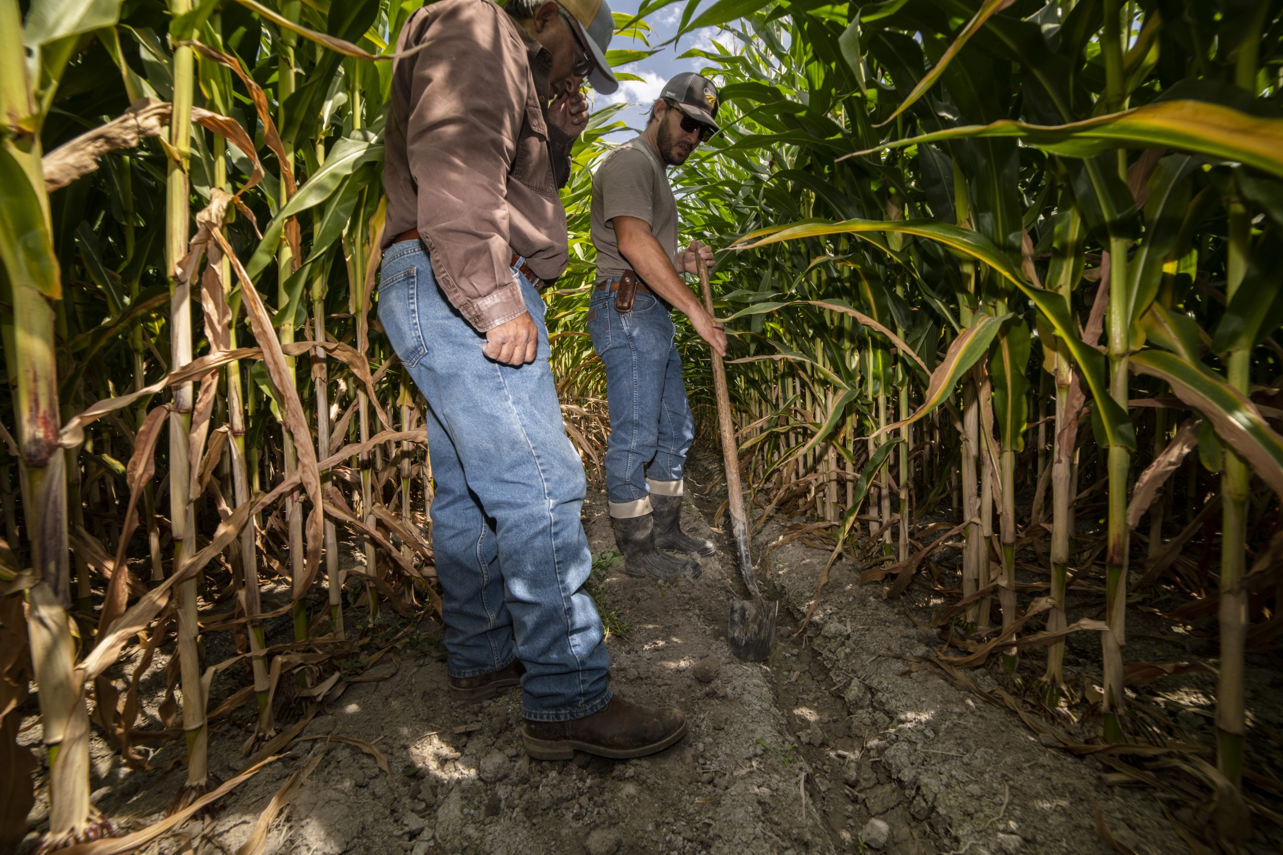
Joe Bernal is a West Slope rancher whose family has been farming near Fruita since 1920. He has water rights that date back to 1898 and, like others in this rich agricultural region, he and his family have abundant water.
Bernal was an early supporter of the drought pool. He and his family participated in an experimental fallowing program in 2016, where they were paid to dry up their fields. He’s confident the problems can be solved.
But he’s also worried that the 500,000 acre-foot pool may not hold enough water to stabilize the river system and that it may not be done fast enough.
“We want to be sure the solution does some good, but the clock is ticking,” he said. “We don’t want to change the culture of this valley or our ability to produce food. But I think things need to move faster. We are taking too long implementing these solutions.”
Checking the averages
As Powell and Mead continue to drop—they were roughly half full just two years ago— Mitchell and Rein are quick to point out that Colorado remains in compliance with the 1922 Compact, which requires the upper basin to ensure 7.5 million acre-feet of water reaches the lower basin at Lee Ferry, Ariz., based on a 10-year rolling average. Right now the average is at roughly 9.2 million acre-feet, although it too is declining as the upper basin’s supplies continue to erode due to drought and climate change.
The Colorado River flows past fruit orchards near Palisade, Colo. Credit: William Woody
Climate scientist and researcher Brad Udall has estimated that the upper basin may not be able to deliver the base 7.5 million acre-feet in a year as soon as 2025. But the upper basin would remain in compliance with the 1922 Compact even then because the rolling average remains healthy.
Still, if the reservoirs continue to plummet as quickly as they have in the past two years, when they dropped from 50% to 30% full, the upper basin could face a compact crisis faster than anyone ever anticipated.
Major water users in the state, such as Denver Water, Northern Water and Pueblo Water, have water rights that post-date, or are junior to, the 1922 water compact, meaning their water supplies are at risk of being slashed to help meet lower basin demands.
The big dry out
Many river advocates hope the drought pool is approved because they believe it is an opportunity to test how the river and its reservoirs will work as the region continues to dry out.
“What we knew in 2018 [when the drought pool was conceived] is that we have more to do,” said Kassen. The drought pool, she said, “was a big win and offers a way of testing what the upper basin can do. It’s squandered if they don’t use it.”
Neubecker and others say it’s becoming increasingly clear that the river’s management needs to be re-aligned with the reality of this new era of climate change and multi-year drought cycles.
And that means that water users in the lower basin and upper basin will need to learn to live with how much water the river can produce, rather than how much a century-old water decree says they’re legally entitled too.
“We’re facing a 21st Century situation that was totally unforeseen by anyone,” Neubecker said, “and we no longer have the luxury of time.”
Jerd Smith is editor of Fresh Water News. She can be reached at 720-398-6474, via email at jerd@wateredco.org or @jerd_smith.
Fresh Water News is an independent, nonpartisan news initiative of Water Education Colorado. WEco is funded by multiple donors. Our editorial policy and donor list can be viewed at wateredco.org.
The Water Desk’s mission is to increase the volume, depth and power of journalism connected to Western water issues. We’re an initiative of the Center for Environmental Journalism at the University of Colorado Boulder. The Water Desk launched in April 2019 with support from the Walton Family Foundation. We maintain a strict editorial firewall between our funders and our journalism.
The Government Highline Canal flows past Highline State Park in the Grand Valley. Water Asset Management, a New York City-based hedge fund, has been buying up parcels of land that are irrigated with water from the canal. Credit: Bethany Blitz/Aspen Journalism
DENVER — Colorado lawmakers are advancing a bill aimed at outlawing water investment speculation, even as they acknowledged their attempt to address the complex problem is an imperfect one.
On Wednesday, members of Colorado’s Water Resources Review Committee voted to put forth a bill in the 2022 legislative session that aims to prohibit a buyer of agricultural water rights from profiting on the increased value of the water in a future sale. The measure is an attempt to prevent out-of-state investors from making a profit off a public resource that grows scarcer in a water-short future driven by climate change.
The draft bill gives the state engineer at the Department of Water Resources the ability to investigate complaints of investment water speculation and fine a purchaser up to $10,000 if they determine speculation is occurring. Those making a complaint could also be fined up to $1,000 if state officials deem a complaint frivolous. A second section of the bill also directs the board of directors of mutual ditch companies to set a minimum percent of agricultural water rights for one purchaser to hold that would trigger the presumption that they are engaging in investment water speculation.
Western Slope state Sens. Kerry Donovan, D-Eagle County, Don Coram, R-Montrose County, and Rep. Karen McCormick, D-Boulder County, are sponsoring the bill.
At the beginning of Wednesday’s discussion, Donovan vented her frustration with what she called mixed messages from water managers. Most seem to agree that stopping investment water speculation is important, but no one can agree on the best way to do that.
“There was a general agreement that investment water speculation was an important issue to work on, so much so… that we invested taxpayer dollars in order to turn out a report,” she said. “We have put resources into addressing this issue and now the feedback is ‘don’t do anything, slow down.’”
Donovan was referring to a report released in August by a work group, which was tasked with exploring ways to strengthen the state’s current anti-speculation laws. The group, made up of water managers and policy experts from across water sectors, came up with a list of concepts on how to prevent water investment speculation. But they did not give clear recommendations to legislators because they could not come to a consensus on which concepts to implement.
Legislators are now saddled with the complex task of figuring out how to protect Colorado’s water from profit-seeking investors without infringing on private property rights.
The lack of consensus points to the varied, sometimes opposing, interests of the work group members. Some municipal water providers may want to see tighter regulations on investment water speculation because as the state continues to urbanize and water moves from agriculture to growing cities, they see speculators as middlemen who have the potential to drive up prices. And although some agricultural water rights owners recognize there could be negative impacts to their communities if water is sold to investors, they also don’t want the state making the process of selling their ranch harder, placing restrictions on who they can sell to or limiting their ability to make a profit.
A lateral brings water from the Grand Valley Irrigation Company Canal to this parcel of land. Colorado lawmakers are advancing a bill that addresses investment water speculation, which some say is happening in the Grand Valley. Credit: Bethany Blitz/Aspen Journalism
Bill opposition
District 58 Rep. Marc Catlin, a Montrose County Republican who also serves on the board of the Colorado River Water Conservation District, voted against advancing the bill, which he said still needs more work. He told the committee they need to be sensitive to the concerns of the people the bill is trying to protect.
“I don’t like speculation, but one of the things we’ve got to think about is the people that are selling,” he told Aspen Journalism after the committee meeting. “If you can’t make money, you can’t make a living.”
Although the organization doesn’t take a formal position on legislation until it’s introduced in the next session, which starts Jan. 12, 2022, the Colorado Farm Bureau also has concerns about the bill and submitted comments to the committee. The organization’s comment letter urges the committee to slow the conversation down and not approve the proposal.
Molina rancher Carlyle Currier is the president of the farm bureau and has a seat on the Colorado Basin Roundtable. He said changing Colorado’s already-strong anti-speculation laws could do more harm than good and lead to unintended consequences for agricultural producers. He added that it was troubling that the committee advanced a bill even though the task force did not recommend any changes to policy.
“To set up a task force and ask them for recommendations and then to basically ignore their work because they didn’t like the results of what the task force came up with is, to me, a little troubling,” Currier said.
Water from the Colorado River irrigates farmland in the Grand Valley. Colorado legislators have advanced a bill aimed at preventing investors from profiting off the state’s water. Credit: Brent Gardner-Smith/Aspen Journalism
Speculation conversation
Speculation has been a hot topic of discussion on the Western Slope recently, especially in the Grand Valley, where a New York City-based private-equity firm has been acquiring irrigated farmland. Water Asset Management is now the largest landowner in the Grand Valley Water Users Association, which provides water for farmers in the valley. But under Colorado water law, as long as WAM keeps putting the water to “beneficial use” by keeping the land in agricultural production — which it appears to be doing — it doesn’t count as speculation.
For all the talk about water investment speculation, there is little evidence it’s happening on a large scale on the Western Slope. In some ways, the effort at trying to stop speculation is really a conversation about a broader fear: the loss of agricultural land and with it, a way of life and a part of Colorado’s history, culture and identity. The work group identified the large-scale, permanent dry-up of agricultural lands as the No. 1 risk from speculators.
“Every other week I get a story of someone whose land just got bought up and they are no longer growing hay, they are no longer running cattle,” Donovan told the committee.
But land changing hands or even changing water use from agriculture to cities — as long as it’s done with the approval of the water court — is not the same as investment water speculation.
“There are some outsiders buying, but they haven’t changed the use of those farms, so we can’t really say, ‘what are you doing?’” Catlin said. “We’ve got to be careful to not run from shadows.”
The committee voted 8-2 to advance the bill as a way to keep working on solutions. Sen. Jeff Bridges, a Democrat who represents District 26 in Arapahoe County, said legislators could always kill the bill if they can’t make it work in the next session.
“I’m inclined today to say yes to this and immediately get to work,” he said. “I think we should move forward today with some kind of vehicle to continue this conversation.”
The Water Desk’s mission is to increase the volume, depth and power of journalism connected to Western water issues. We’re an initiative of the Center for Environmental Journalism at the University of Colorado Boulder. The Water Desk launched in April 2019 with support from the Walton Family Foundation. We maintain a strict editorial firewall between our funders and our journalism.
The Green River is the most significant tributary of the Colorado River. Journalist Heather Hansman floated the Green in a pack raft to explore water issues in the American West, then wrote a fascinating book about her journey. We also talk to Heather about her reporting on water issues on the Navajo Nation. Heather’s new book, “Powder Days: Ski Bums, Ski Towns, and the Future of Chasing Snow” was released this month.
Heather Hansman, author and water journalist Heather‘s writing appears in such publications as The Guardian, Sierra and The New York Times, and she is is an environmental columnist for Outside online. Her 2019 book “Downriver: into the Future of Water in the West” explored the western U.S. water system during a trip down the length of the Green River. Her latest book book “Powder Days: Ski Bums, Ski Towns, and the Future of Chasing Snow” was released in November of 2021. Starts at 1:03
New book: “Powder Days” The book is described as “an exhilarating journey into the hidden history of American skiing, offering a glimpse into an underexplored subculture from the perspective of a true insider.” Starts at 34:10
If you’re interested in appearing on the show, please contact Water Desk Director Mitch Tobin at mitchtobin@colorado.edu. If you’d like to share your comments and questions, you can reach us at waterdesk@colorado.edu, or on Twitter and Facebook.
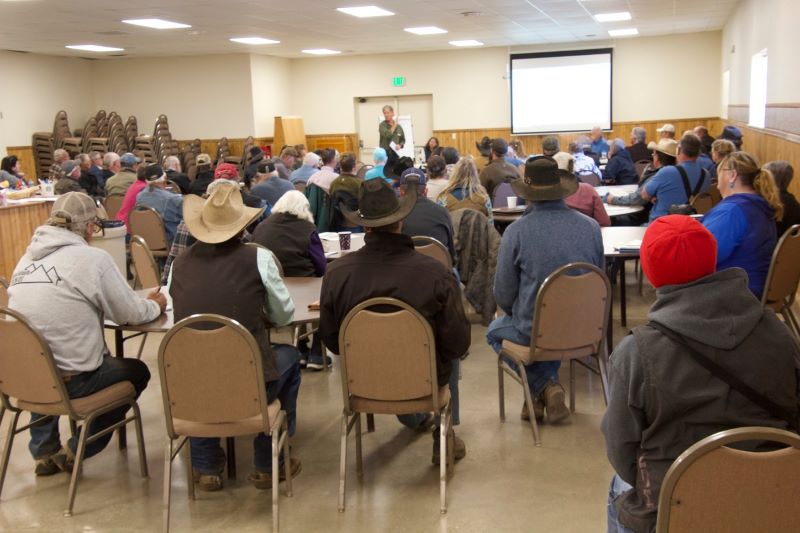
Ranchers and other water users gather at a stakeholder meeting in North Park on Oct. 22 to ask questions and provide input as state officials make case for measuring devices and recording. Credit: Allen Best
By Allen Best
As the gap between water supplies and demands narrows in northwestern Colorado, state officials want to ensure that, as best as reasonably can be done, every last drop gets measured and recorded.
They made their case to about 60 ranchers in North Park’s Walden, Colo., on Friday in the fifth of six stakeholder meetings during October that will conclude tonight with a meeting in Craig.
The proposed rules governing the Yampa, White and North Platte River basins would require that headgates, which allow water diversions into ditches, be supplemented with measuring infrastructure, either flumes or weirs, to track the amount of water being diverted. The rules would also institute protocols for reporting the measurements, for collection in state databases. Authority to require the measuring and reporting is clearly defined by state law, but the law leaves room for discretion about the particulars, hence the stakeholder process.
In an already drought-stricken region likely to become hotter and drier yet in the 21st century, those measurements will become ever-more important in administering water rights. The Yampa River this century has carried on average 6% less water than it did during the 20th century. On the White River, flows have fallen 19%.
Already, there is concern that Colorado will be forced to curtail diversions of water rights dated later than the 1922 Colorado River Compact if the aridification of the Colorado River Basin continues, said Kevin Rein, the state water engineer, at the outset of the meeting in Walden.
The compact specifies that Colorado along with Wyoming, Utah and New Mexico “will not cause the flow of the river” at Lee Ferry, at the top of the Grand Canyon, “to be depleted below an aggregate” of 75 million-acre feet for any period of 10 consecutive years. Colorado and the three other upper basin states are in relatively good shape—for at least the next couple of years. In the last decade, 92 million acre-feet have flowed past Lee Ferry toward Arizona, Nevada, California and, eventually, Mexico.
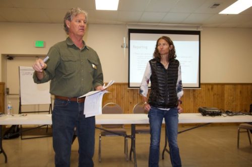
Kevin Rein, Colorado state water engineer, explains why Colorado needs stepped-up measuring of water diversions in the North Park and other rivers in Northwest Colorado while Erin Light, Division 6 engineer, looks on during a meeting in Walden on Oct. 22. Credit: Allen Best
But if below-average becomes the new normal, as climate scientists warn almost certainly will be the case, Colorado may be forced to defend its diversions in light of the compact. “When they come in and ask for water, we can’t refuse if we have no data,” said Mike Sullivan, the deputy state water engineer.
The state water officials pointed to the Aug. 2021 report Lessons Learned from Colorado Experiences with Interstate Compact Administration issued by the Hutchins Water Center at Colorado Mesa University and MacIlroy Research and Consulting. “Confronting the limits of a water supply is a painful experience,” the report said after studying the Republican, Arkansas and Rio Grande basins. “Across each of the basins, earlier action to address potential compact and supply issues has enhanced the control communities have to develop and choose their own, less painful, options.”
The North Platte River does not flow into the Colorado River. It’s east of the Continental Divide but separated from the Front Range by the Medicine Bow and other mountain ranges. So why the need to measure water in North Park the same as in the Yampa and White river valleys?
Because it’s good to have the data should it be necessary as required by other interstate agreements, in this case involving Wyoming and Nebraska, said Sullivan.
But there’s another reason for more rigorous accounting of diversions, said the state water officials. Owners of water rights can best look out after their own interests by documenting their water use. This guards against those rights being placed on lists of abandoned water rights that state law requires be issued every 10 years. The most recent list for all river basins, including North Park, was issued last year.
Measuring devices also give those with more senior water appropriations the right to divert their legal entitlements in water-scarce years. And in the case of land sales with connected water rights, it gives owners the proof of water use to demonstrate value to potential purchasers.
In several river basins in Colorado, notably those east of the Continental Divide, measurements became crucial as early as the 19th century. In those river basins where water users experienced an earlier squeeze between supplies and demands, those with senior water rights began placing calls that required those with newer—and hence more junior— rights upstream to cease or cut back diversions.
In Water Division 6, which includes the North Platte, Yampa and White river basins, 54% of headgates had appropriate measuring devices as of April. This compares with upwards of 90% in several other water divisions of Colorado.
Overlapping the new rules is a proposal being considered by the Colorado Division of Water Resources to designate the Yampa River as over-appropriated. Most rivers in the state are already considered over-appropriated, in some cases over a century ago. Segments of the Yampa—including the river upstream from Steamboat Springs and several tributaries—already have been so designated. This designation will require irrigators drilling wells to have water that they can use to augment streamflows if there is a call on the river by a senior user. Improved measuring will assist in administration. Meetings to gather input were scheduled for Monday night in Craig and Thursday night in Hayden.
State officials hope to get the measurement rulemaking as well as the Yampa designation completed by early next year. Rules will be unique to the needs of Northwest Colorado, just as rules governing the Republican and Arkansas River basins are unique to the interstate water agreements and other circumstances governing water use in those basins.
North Park was particularly warm and dry last winter. One rancher after the Walden meeting recalled that it was possible to drive across his hay meadows all of last winter whereas many years he has to plow the driveway almost daily.
“It was pathetic, really,” said Keith Holsinger, standing on a bridge over the Michigan River east of Walden where he grows hay on 800 acres. One of his neighbors, who usually gets 500 to 600 tons of hay, got only 90 tons this year, he reported.
Holsinger has lived on the ranch all of his 77 years. His water rights range from among the oldest in North Park, an 1885 decree with a priority number of 32, to more junior rights of 240th in priority.
He remembers putting in the first measuring device sometime after the drought of 1977. His last device, a weir, he had installed last year.
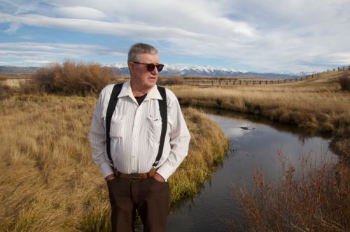
Keith Holsinger has been installing measuring devices on ditches for his ranch along the Michigan River in North Park for several decades. Credit: Allen Best
During the meeting, some skepticism was voiced about the coming measurement rules. State representatives characterized the relationship between water users and state authorities as one of cooperation and trust. But one audience member pushed back. Implementation seemed to be discretionary, he said. “It’s a trust issue, and I’m sorry to say I don’t have a lot of faith.”
But as for the need for the rules, Holsinger is already persuaded. “If it’s free water in priority, if you want that water, you had better have a headgate and weir,” he said. “It’s as simple as that.”
The most significant discontent voiced in the background of the meeting agenda was about the high turnover in water commissioners. It’s a common problem across Colorado, say state water officials, as the job is by nature semi-seasonal. But in conversations after the meeting, North Park residents suggested that if the state wants water users to be partners in administration, the state needs to allow proper resources. A water commissioner has between 350 and 500 headgates to check, and there’s a learning curve.
Some people wanted to know why the state wanted the ability to lock headgates. State representatives said they rely primarily on voluntary compliance with water allocations but need the ability to force compliance if diverters take more than they are entitled to.
“In 20-some years, I have probably ordered a half-dozen headgates locked,” said Sullivan. “If we can’t get someone to keep their hands out of the cookie jar, we lock the cookie jar.”
As for the specific type of weir or flume, there are several formal varieties as well as less formal ones. They can be expensive, but none of the irrigators in Walden indicated that cost alone is an issue. Erin Light, the Steamboat Springs-based water engineer for Division 6, said she had seen a flume made of a road sign. It worked, she reported. Sullivan reported seeing one made of rock that worked effectively.
Said Sullivan, speaking to people mostly old enough to remember a bestselling small-model car in 1979 and 1980, “We don’t want to require a gold-plated Cadillac headgate when a Chevette will do.”
Long-time Colorado journalist Allen Best publishes Big Pivots, an e-magazine that covers energy and other transitions in Colorado. He can be reached at allen@bigpivots.com and allen.best@comcast.net.
Fresh Water News is an independent, nonpartisan news initiative of Water Education Colorado. WEco is funded by multiple donors. Our editorial policy and donor list can be viewed at wateredco.org.
The Water Desk’s mission is to increase the volume, depth and power of journalism connected to Western water issues. We’re an initiative of the Center for Environmental Journalism at the University of Colorado Boulder. The Water Desk launched in April 2019 with support from the Walton Family Foundation. We maintain a strict editorial firewall between our funders and our journalism.
A view, looking across the White River, of the location of a potential off-channel dam and reservoir being studied by the Rio Blanco Water Conservancy District. The conservancy district has secured a $330,000 grant from the River District’s Community Funding Partnership for the permitting phase of the project. CREDIT: BRENT GARDNER-SMITH/ASPEN JOURNALISM
The Colorado River Water Conservation District board of directors approved a request to partially fund the permitting costs for a dam and reservoir project in northwest Colorado.
The Rio Blanco Water Conservancy District asked the River District for $3 million over three years for federal and state permit work for the construction of the Wolf Creek Reservoir. But the conservancy district did not get the full amount it asked for. At staff’s recommendation, the River District committed to $330,000 — one year of initial funding from the Community Funding Partnership. River District staff encouraged Rio Blanco to apply for more project funding in coming years.
Amy Moyer, River District director of strategic partnerships, said the district did not have the funding to provide the full $3 million over three years.
“We felt like ($330,000) was a good amount to help Rio Blanco hire a contractor they will need to start the permitting process,” she said.
In January, Rio Blanco secured a water right for a 66,720-acre-foot reservoir between Rangely and Meeker. The conservancy district is proposing an off-channel reservoir with a dam 110 feet tall and 3,800 feet long, with water that will be pumped into the Wolf Creek drainage from the White River.
Rio Blanco said it will use the funds for the National Environmental Policy Act permitting process, which will be administered by the Bureau of Land Management, using a third-party contractor. Rio Blanco estimates the permitting will take three to five years at a cost of $6 to $10 million.
In its application, Rangely-based Rio Blanco said that the River District’s support of the permit phase is essential for the eventual development of the project.
“The project provides a desperately needed new storage reservoir for the White River basin,” the application reads. “The White River basin currently does not have adequate storage to meet the current water needs during drought conditions or any additional future water needs within the basin.”
No River District directors voted against the funding. Rio Blanco County representative Alden Vanden Brink abstained from voting because he is the general manager of the Rio Blanco Water Conservancy District.
“I support this concept,” said Gunnison County representative Kathleen Curry. “Investing in a permitting process is wise right now.”
Moffat County representative Tom Gray wondered if funding this request would mean the River District has a moral obligation to approve future funding requests for the Wolf Creek project. But River District General Manager Andy Mueller encouraged board members to look at it as a one-time request because the future of the overall project is still uncertain.
“It is possible that this applicant could have the whole permitting process blow up on them,” Mueller said. “Something beyond our control may occur. … Think of it on an application-at-a-time basis.”
The Wolf Creek project will also need permits from the State Historical Preservation Office, the U.S. Fish & Wildlife Service, the Army Corps of Engineers, the Colorado Department of Public Health and Environment and a consultation under the Endangered Species Act.
Project history
Rio Blanco has budgeted a minimum of $250,000 per year to contribute to the permitting process. Since planning first began in 2013, Rio Blanco and its funding partners, including the Colorado Water Conservation Board, have spent $2.1 million on the project. The project has the support of Rio Blanco and Moffat counties and the Town of Rangely, but so far these governments have not made funding commitments. Rio Blanco estimates the total cost to build the reservoir at $142 million.
Securing the water right for the project took longer than Rio Blanco expected because for five years, Colorado’s top engineers at the Department of Water Resources argued the project was speculative because Rio Blanco could not prove a need for the water. The water right that was eventually granted after years of back-and-forth in water court gave Rio Blanco the amount of water it was seeking, but does not allow the district all the water uses it initially wanted.
The decree granted Rio Blanco a water right for municipal use for the town of Rangely; augmentation within its boundaries; mitigation of environmental impacts; hydroelectric power; and in-reservoir use for recreation, piscatorial and wildlife habitat. The conservancy district will not be able to use the water for irrigation, endangered fish or augmentation in the event of a compact call.
Vanden Brink said there is a sense of urgency to build the Wolf Creek project. He said he is thrilled at the River District’s grant.
“We think it’s a great partnership with the River District,” he said. “It’s critical that this thing gets done.”
The River District’s Community Funding Partnership was established last year when voters passed ballot measure 7A, increasing the River District’s mill levy. Eighty-six percent of the revenue from the tax hike goes toward funding water projects in five categories: productive agriculture; infrastructure; healthy rivers; watershed health and water quality; and conservation and efficiency.
Aspen Journalism covers water and rivers in collaboration with the Craig Press and other Swift Communications newspapers. This story ran in the Oct. 21 edition of the Craig Press and Steamboat Pilot & Today and the Oct. 25 edition of The Aspen Times.
The Water Desk’s mission is to increase the volume, depth and power of journalism connected to Western water issues. We’re an initiative of the Center for Environmental Journalism at the University of Colorado Boulder. The Water Desk launched in April 2019 with support from the Walton Family Foundation. We maintain a strict editorial firewall between our funders and our journalism.
Colorado West Slope water officials turned up the volume on the call for action around water and climate change, calling it a “train wreck.”
At the Colorado River District’s Annual Water Seminar Oct. 1, Andy Mueller, general manager of the Glenwood Springs-based district, described climate change as a train wreck that needs to be stopped.
“For a decade or more, we have seen the train wreck slowly moving this way. It has picked up speed pretty significantly in the last couple of years, and the question is how do we avert the train wreck,” Mueller said.
He pointed to changes already underway as a result of the warming climate, and those that will be necessary. Uses of the Yampa River as it flows through Steamboat Springs have been curtailed for eight of the last 14 years because of high temperatures and low flows, he said. There have been fish kills in the Colorado River and other impacts to outdoor recreation. Ski areas face a shorter operating season and those in lower elevations may not survive. Agriculture users may need to remove marginal land from irrigation and take stock of their least productive crops.
“I think at every level our folks who are paying attention to the science and the hydrology, there is an increasing sense of urgency in the Colorado River Basin, and it’s shared by folks on the ground today, from ranchers in the Yampa River Valley to farmers in the Uncompaghre Valley to major urban providers like Denver Water. We all recognize there is something very different going on than there was 10 years ago in the Colorado River.”
“Climate change is barreling through the doors of America,” said Michael Connor, the second-highest ranking official in the Interior Department during the Obama administration and now a Washington D.C.-based attorney.
Brad Udall, a senior scientist and scholar at Colorado State University, said he began working on climate change in 2003. “I mostly got a lot of dirty looks,” he said. That has changed. “I have decided that misery loves company.”
Udall stressed the importance of inflows into Lake Powell from Colorado, New Mexico, Wyoming and Utah, the states that comprise the Upper Colorado River Basin. Those inflows have averaged 8.4 million-acre feet since 2000.
Each year 500,000 acre-feet is lost to evaporation, leaving 7.9 million-acre-feet for release from Lake Powell. That’s less water than is needed to comply with the requirements of the 1922 Colorado River Compact. Unless flows improve, said Udall, the Upper Basin states may have to forego use of some of their own Colorado River supplies to ensure Arizona, California and Nevada, the Lower Basin states, receive their legal share.
How did we get to this point? Several researchers in the last five years have fingered rising temperatures as a crucial factor in creating what Udall and his collaborator, the University of Michigan’s Jonathan Overpeck, in a famous 2017 paper, called “hot drought.” They said temperatures alone explained at least a third of the lesser river flows.
Loss of snow may further exacerbate warming. A 2020 paper by P.C.D. Milly and K.A. Dunne in Science found a 9.3% loss in Colorado River flows with each one degree Centigrade in warming. A key finding, said Udall, was that as shiny, reflective snow recedes, the amount of absorbed radiation rises.
A decade ago, there was no clear signal whether a warming climate would affect precipitation on the Western Slope. A picture is starting to emerge, with Southwestern Colorado now at significant risk of precipitation — and runoff — declines, he said.
The San Juan River near Bluff, Utah, had 30% less water in 2000-2019 as compared to 1906-1999. The Colorado River at Glenwood Springs had a 6% decline.
Soil moisture also matters. If the soil remains dry from the previous year, it sops up more of the potential runoff. In 2020, the snowpack was 100% of average but the runoff was 50%. That soil-moisture deficit played into this year’s even worse runoff, 30% of average from a snowpack that was 90% of average.
Dr. Gigi Richard, director of the Four Corners Water Center at Ft. Lewis College in Durango, was asked whether she detects more acceptance of climate change as impacting water.
“Yes,” she answered. “In Western Colorado, it’s really hard to deny that from day to day, year to year, that we are feeling the impacts of climate change.”
Connor, the former Interior official, pointed out that tribes in the Colorado River Basin have reserve rights, making them superior to the terms of the Colorado River Compact. Because of the sheer volume of those rights, especially in Arizona, many see them as crucial in whatever new Colorado River operating agreements are negotiated going forward.
“You need to be able to provide the tribes value for their rights,” if tribes are asked to give up use of those water rights, Connor said.
Muller warned of the need for adaptation and offered a conciliatory approach, saying water interests would need to unite to find solutions.
The River District, he noted, sought and obtained a tax increase from voters in an election that was supported by both the Grand Junction Chamber of Commerce and the Environmental Defense Fund. “When,” he asked, “is the last time you saw those two groups on the same page?”Long-time Colorado journalist Allen Best publishes Big Pivots, an e-magazine that covers energy and other transitions in Colorado. He can be reached at allen@bigpivots.com and allen.best@comcast.net.
Fresh Water News is an independent, nonpartisan news initiative of Water Education Colorado. WEco is funded by multiple donors. Our editorial policy and donor list can be viewed at wateredco.org.
The Water Desk’s mission is to increase the volume, depth and power of journalism connected to Western water issues. We’re an initiative of the Center for Environmental Journalism at the University of Colorado Boulder. The Water Desk launched in April 2019 with support from the Walton Family Foundation. We maintain a strict editorial firewall between our funders and our journalism.
Colorado communities from Greeley to Durango have identified $20.3 billion in water projects that will help ensure residents have adequate water, that agricultural supplies are protected, and that rivers and streams can continue to support fish and wildlife as population growth, chronic drought and climate change threaten future water supplies.
According to the 2015 Colorado Water Plan, the state faces a gap between expected demand and existing water supply of as much as 560,000 acre-feet per year for cities and industry by 2050.
Colorado is home to eight major river basins, each of which is governed by a public roundtable. A ninth basin roundtable represents the Denver metro area.
These entities are charged with evaluating each region’s water needs and projects that would help meet those needs. Funding for those projects will likely come from several sources including local governments and water utilities, and state and federal funding.
Known as basin implementation plans (BIPs), the working documents summarizing those projects and needs were submitted to the state earlier this month and are open for public comment through Nov. 15. These plans are updated versions of the originals that were initially developed by the roundtables in 2015 to inform the Colorado Water Plan.
Since 2015, the Colorado Water Conservation Board (CWCB), which is responsible for implementing the water plan, has spent some $500 million in grants and loans helping fund water projects across the state, according to Russ Sands, head of water supply planning at the CWCB.
The plans are a key part of Colorado’s larger statewide effort to ensure it has adequate water supplies. The Colorado Water Plan is the primary document that guides state water policy and it relies on the planning efforts of the local roundtables.
“The basin roundtables represent a grassroots initiative that allow access to state planning,” Sands said.
The South Platte and Metro basin roundtables, which submitted a combined plan, have the most costly project list at $9.8 billion. This figure includes costs of projects that are planned, currently being implemented, or recently completed.
The South Platte Basin is home to the largest population centers and covers metro Denver, Fort Collins, Boulder, Greeley and Sterling, among dozens of other communities.
The next largest project list comes from the Colorado River Basin on the West Slope. It has identified $4.1 billion in water projects that will help it ensure its residents’ future needs are addressed.
The roundtables, made up of water professionals, citizens and local elected representatives, receive funding to operate from the CWCB. They also help fund projects each deem important to meeting a local need, whether it is improving an irrigation company’s diversion structure, building a new reservoir, funding a stream restoration project, or building a new kayak park.
The plans are “important because the process was to identify gaps in what a basin needs for irrigated agriculture, municipal and industrial, and environmental and recreational needs,” said Jason Turner, who chairs the Colorado River Basin Roundtable. “We have a robust mix of all sorts of projects and it allows people who, say, live on the Roaring Fork [a tributary] to understand some of the bigger Colorado River issues as well.”
Barbara Biggs is chair of the Metro Roundtable. She said the project list for the combined South Platte and Metro roundtables represents one of the most detailed assessments of water needs on the Front Range.
“Just creating the project database is a huge step in the right direction because it will allow us to track and measure our success,” she said.
The basin plans are scheduled to be finalized at the end of January 2022 and will be incorporated into an update of the 2015 Colorado Water Plan next year.
Jerd Smith is editor of Fresh Water News. She can be reached at 720-398-6474, via email at jerd@wateredco.org or @jerd_smith.
Fresh Water News is an independent, nonpartisan news initiative of Water Education Colorado. WEco is funded by multiple donors. Our editorial policy and donor list can be viewed at wateredco.org.
The Water Desk’s mission is to increase the volume, depth and power of journalism connected to Western water issues. We’re an initiative of the Center for Environmental Journalism at the University of Colorado Boulder. The Water Desk launched in April 2019 with support from the Walton Family Foundation. We maintain a strict editorial firewall between our funders and our journalism.