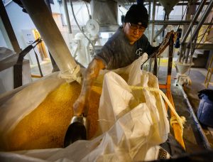
Oil stains mark water levels in a produced storage pond south of Malaga. The water here has been treated to remove much of the toxic residue from fracking, and is stored alongside a freshwater pond for mixing and re-use in fracking operations. Photo by Don J. Usner / Searchlight New Mexico
This story is the first of a two-part series on New Mexico’s water problems. Read the second part here.
Magdalena, N.M. — Mayor Richard Rumpf drives slowly through town — population 870 — and gestures toward the new ambulance, the volunteer fire department that he captains, the library housed in a converted train station. His role in the community spans everything from substitute teaching at the local school — “State champs again,” he says proudly of the boys basketball team — to playing Santa Claus in the Christmas parade.
“This is my community,” Rumpf says. “I put a lot of effort into it.”
A large part of that effort goes to one of Magdalena’s primary concerns: water management. As climate change makes the state ever hotter and drier — threatening small towns, rivers and cherished landscapes — few places are taking this problem as seriously as Magdalena.
Tucked away in a corner of Village Hall behind a box of Christmas decorations is a computer screen that displays water levels in the town’s well in real time. It may not look like much, but this state-of-the-art well-monitoring system is one of the only indications of what happened in Magdalena eight years ago when, without warning, the town’s only functional well went dry.
The utilities manager at the time measured the water level once per year. But when residents noticed air bubbles in their water lines, he went to check the well — fed by a single underground aquifer — and found that the water had dropped 15 feet since his previous measurement. It was sitting below the reach of the pump. Some residents went without running water for almost a week while others suffered milder inconveniences. A group of local business owners filed a lawsuit citing negligence in maintaining the town’s water infrastructure.
Magdalena Mayor Richard Rumpf pauses in the village office, where boxes of Christmas decorations compete for space with files, maps and a state-of-the-art water monitoring system. In addition to his role as mayor, Rumpf is a substitute teacher at the local school, serves as captain of the volunteer fire brigade, and plays Santa Claus in the annual Christmas parade. Photo by Don J. Usner / Searchlight New Mexico
Now, though the memory of that well failure is little more than a blip for many residents, it has changed the way the village thinks about water. For Rumpf, it’s become a question of survival.
Rumpf says he now thinks about Magdalena’s water system “every single day.” He’s fortifying the village against future scarcity — monitoring wells, building new water tanks and conserving water. He has secured grant money to help with infrastructure, and is committed to protecting the village’s water future.
But Magdalena’s innovative approach to water conservation is an anomaly in New Mexico. The state’s rural areas often lack the resources for robust water data systems. Instead of advanced well-monitoring systems, steel tape-measure soundings track water levels. Some small towns keep records of water levels by handwriting them on the walls of well houses, which are periodically painted over — obliterating important data and making them more vulnerable to well failure.
Often, it takes a crisis like Magdalena’s for a small-town government to recognize the problem and act on it. And even as news of the drying Southwest has become common knowledge, the New Mexico state government has done almost nothing to prepare for this future, failing to even collect enough basic data to determine how much water there exists in the system. By the time New Mexicans realize the stakes, it may be too late.
“It could be 100 years, or 80 years, or 60 years — we’ve got a limited amount of water,” says Dave DuBois, New Mexico’s state climatologist. “We’ve got these long horizons, but that doesn’t mean we need to blow through that and then figure out what to do.”
Water data’s big black hole
Magdalena’s well crisis was a wake-up call for Stacy Timmons, associate director of hydrogeology programs at the New Mexico Bureau of Geology. Timmons is based at New Mexico Institute of Mining and Technology in Socorro, the “big city” closest to Magdalena, and when the town started having water trouble it called her in to help.
With her small team, Timmons started trying to put together information about the history of the well and the aquifer it draws from. The reports they needed weren’t available anywhere and they spent months piecing together the data required to solve the town’s problems.
“It was a bit eye-opening as to how much time it took, and in a moment of crisis like that when they were out of water, time wasn’t something that we had a whole lot of,” says Timmons.
She soon realized that the problem wasn’t isolated to Magdalena: All over the state there were huge gaps in water data. There was no centralized database with records or measurements — everything had to be pieced together document by document.
The problems extend beyond small-town water governance. The state as a whole also does little to track how much water flows in and out of its rivers and aquifers. There isn’t a state agency that tracks how many wells go dry each year, or a single office that can provide a firm answer on how much water is used throughout the state.
It all adds up to a big black hole in water information, which means that no one in the state of New Mexico knows how much water the state has or how much time remains before it disappears.
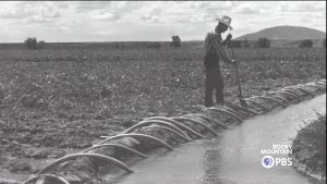
Irrigation water floods a pecan orchard near Las Cruces in 2007. Water use continues much as it has since the state’s water use laws were codified more than 100 years ago, allowing practices like flood irrigation. In recent years, farmers have introduced various other methods for efficiency. Photo by Don J. Usner / Searchlight New Mexico
Many water experts say that assembling this information is the critical first step in planning for a future with even less water.
“We could go one way, which is just to throw up our hands and say we’ll just deal with it as it comes,” Timmons says. “The other way would be to really try to nail down exactly how much [water] we have and make sure we can be fair and equitable about everybody getting some.”
But closing these data gaps won’t be easy. Many water measurements require manual labor that can only be done onsite with rudimentary tools. More advanced types of data collection are often prohibitively expensive and require specialized staff. Since her epiphany in Magdalena, Timmons has been busy finding ways to embark on this long arduous process.
She’s already helped launch several groundwater mapping and monitoring projects. She is also in charge of implementing the Water Data Act, a law passed in 2019 that requires state water agencies to standardize information and make it accessible to the public.
But New Mexico has been hesitant to fund these projects. The Water Data Act appropriated only $110,000 in funds from state coffers — hardly enough to organize the state’s water resources.
And while it may be bad now, it’s about to get much worse.
This is not a drought
Across the Southwest, the effects of climate change are already apparent in rising temperatures, thinning snowpacks, and sparse and variable precipitation patterns. These symptoms might be mistaken for the periods of historic drought familiar to longtimers, but unlike past drought cycles, today’s water scarcity will not be alleviated by periods of relative moisture.
All water that ends up in New Mexico’s water budget begins as rain or snow, which either runs off into rivers and streams (i.e., surface water) or seeps into the earth as groundwater, replenishing aquifers.
As rain and snow dwindle, water supplies are acutely affected. Thin snowpacks mean less runoff into rivers and streams, which means less aquifer recharge, which means less groundwater. When surface water is scarce, people start pumping more groundwater. This, in turn, means even less surface water, as drains on aquifers can sap water from rivers and streams.
Andrew Erdmann, the state’s newly appointed water planning program manager, likens the projected reduction in groundwater recharge to “having the interest rates go down on your savings account.” And, experts say, these conditions will only get worse. The only uncertainty is how much worse and how fast it will happen.
DuBois, the state climatologist, recently collaborated on a draft analysis of climate change impacts on water resources as part of the state’s working 50 Year Water Plan. The forecast, he says, is not encouraging.
“Our current drought is more like what we’re going to see in the future, meaning low reservoir levels, little to no irrigation, high temperatures. That’s our trajectory.”
The water levels in New Mexico’s largest lake, the Elephant Butte Reservoir, have decreased significantly in recent decades. Animation by Joe Rull / Searchlight New Mexico
He says the severity of these outcomes depends on different pollution levels, and there’s no way to know exactly what the future will hold. But the worst case would be no water in some areas of the state.
For many New Mexicans, the idea of a home without water seems like a dystopian future that will never become reality. Water use continues much as it has since the state’s water use laws were codified more than 100 years ago — allowing practices like flood irrigation for crops like alfalfa and pecans — in addition to more recent water-sucking industries like fracking and newly legalized recreational cannabis. For DuBois, these attitudes are of great concern.
“We have to be able to convince people that this is real, it’s coming and we need to plan and adapt for the future,” he says.
Tough choices
For much of New Mexico, the worst-case water scenario is already here.
Last year, the state paid farmers along the Rio Grande to fallow more than 1,200 acres of fields to save water. In the Clovis-Portales area, near the Texas border, aquifer levels have dropped more than 150 feet in some places, threatening drinking water supplies. In Las Vegas, locals can no longer swim and play in the natural pools that their parents and grandparents once enjoyed along the Rio Gallinas.
In 2021, the Rio Grande was bone dry by the time it reached Anthony, N.M. / Photo by Michael Benanav for Searchlight New Mexico
It’s inevitable that other communities across the state will face similar water challenges sometime in the coming years or decades. Once-thriving rural communities could become ghost towns, and cities could struggle to expand unless they have the information needed to plan ahead.
“Data is what fundamentally underlies and supports that type of decision making,” says Timmons. “In times when a community runs out of water we can’t spend a month and a half trying to find data about it.”
Even with this data, climate change means that over the next few decades New Mexican society will need to make tough choices about who gets water and who goes without. By ignoring our knowledge gaps now, we may get no future choices. Instead, climate and geology will decide who wins and who loses the water lottery.
The Water Desk’s mission is to increase the volume, depth and power of journalism connected to Western water issues. We’re an initiative of the Center for Environmental Journalism at the University of Colorado Boulder. The Water Desk launched in April 2019 with support from the Walton Family Foundation. We maintain a strict editorial firewall between our funders and our journalism.
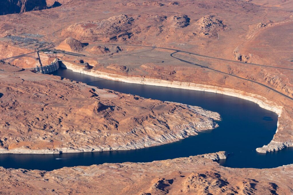
An aerial shot of the Colorado River at Lake Powell near Page, Arizona, shows the site where Utah’s Lake Powell Pipeline plans to tap into the water source just upstream of the Glen Canyon Dam, for transport to Sand Hollow Reservoir. The white bands of rock along the river edges, left by mineral deposits from past water contact, show how much the river level has dropped in recent years. Photo by Ted Wood/LightHawk
This story was originally published by The Spectrum on June 3, 2021.
Drive in any direction through Washington County, Utah and you’ll soon see yellow bulldozers piling up mounds of red dirt and black lava rock to make way for yet another housing development. According to the recent U.S. census, Utah was the fastest-growing state in the nation between 2010 and 2020, increasing its population at a blisteringly fast rate of 18.4%. And in its southwest corner, Washington County, with its stunning vistas, National Park access, recreation opportunities and warm, sunny climate led the state in that trend, attracting nearly 50,000 new residents over the last decade, a 36% increase over its 2010 population.
Water Desk Grantee Publication
This story was supported by the Water Desk’s grants program.
Those 50,000 new people are just the beginning of a growth pattern projected by the Gardner Institute to flood Washington County with 321,000 additional residents over the next 45 years, to reach a local population of 509,000 by 2065. That number of people — 80% of the current population of Las Vegas — will require a lot of water in this desert landscape, more than is locally available at our current rate of use.
A Growing Dilemma
In 2019, Washington County locals used, on average, 159 gallons of water per person per day from the domestic public supply (indoor and outdoor home use). This is according to the most recent calculation by the Washington County Water Conservancy District (WCWCD), the entity charged with securing the region’s future water access. This number is hotly disputed, however, with St. George City’s own Water Services Director recently quoting a daily per person water use average of 241 gallons and other sources calculating per capita use at 248 gallons per day across Utah and as high as 325 daily gallons for residents of arid Washington County.
Water use across a community is notoriously difficult to measure and compare due to different methods of metering and accounting for reabsorption. But nationwide estimates using data collected by the U.S. Geological Survey suggest the average American uses only 88 gallons of water per day at home, half of the most conservative calculation for Washington County residents.
Whatever the specific reality, Utah — the second driest state — has long been criticized for having among the highest rates of water use in the country. Despite the WCWCD recently celebrating a 30% reduction in per capita water waste since 2000, conservationists say the state could do much more.
A bit of math shows why this may be beneficial.
Even at the lowest estimate of 159 gallons of water per person per day, by 2065 Washington County will need access to more than 29 billion gallons per year to quench the thirst of its population, businesses, farms and landscaping. At the upper estimate of 325 gallons per person per day, the county would go through more than 60 billion gallons of water each year.
Yet in 2021, the WCWCD reported that the reliable local supply of potable water currently tops out at 22.8 billion gallons per year, down from the 23.8 that was reported in a 2018 presentation by the WCWCD.
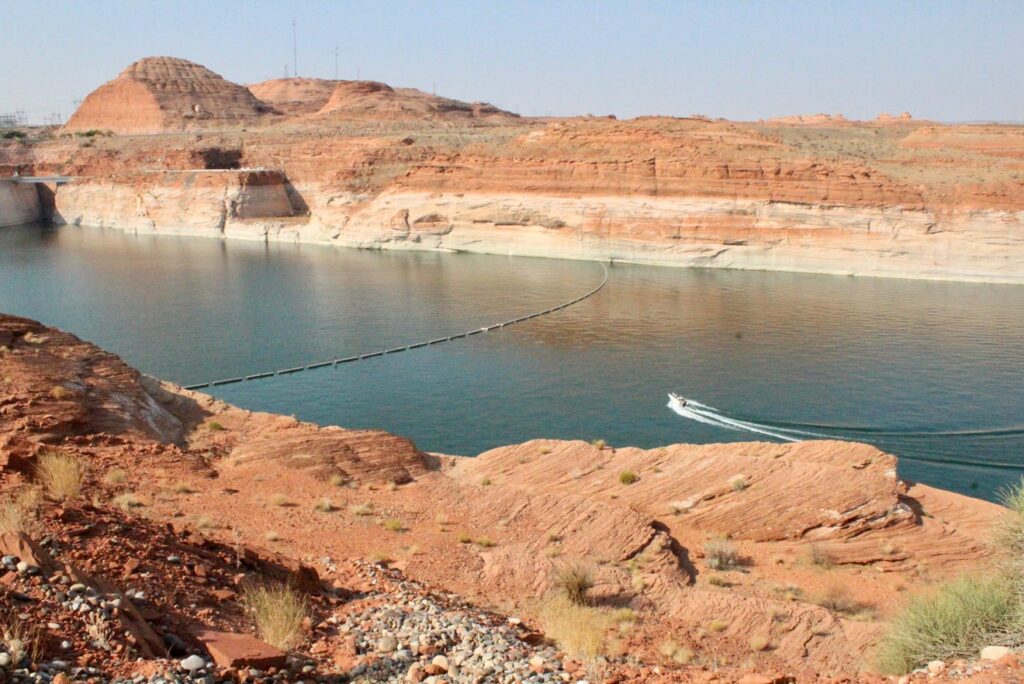
A motorboat speeds towards the approximate location, just above Glen Canyon Dam, where the Lake Powell Pipeline is proposed to draw up Colorado River water for transport to St. George. Photo by Joan Meiners.
A Solution?
The WCWCD, along with the Utah Division of Water Resources, saw this problem coming as early as the 1990s, and started making plans to import Colorado River water from Lake Powell via a buried pipeline that would stretch 140 miles through rocky desert terrain, crossing some tribal lands and sensitive habitats. The project has inched its way forward over the decades since, finally advancing its federally-required Environmental Impact Statement through the public review process during the Trump administration, which identified the pipeline as one of its infrastructure priorities.
But the project has also been mired in controversy since its inception, with objections raised about its economic feasibility, its environmental consequences and whether there will even be enough water in the Colorado River to fill the pipeline once it is built given recent record-setting droughts and ongoing climate-related flow declines. The Colorado River is currently the main source of water for 40 million people across the Southwest. But as the region’s population has grown and climate change has taken its toll, the river’s two main reservoirs have dropped dramatically, exposing white layers of rock that had been submerged since the dams were built.
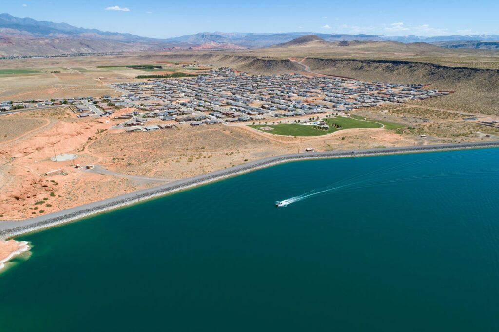
An aerial view looking over Washington County’s Sand Hollow Reservoir towards the Dixie Springs Park and subdivision. Photo by Ted Wood.
Controversy and science in the Colorado River Basin
As of late May, the U.S. Bureau of Reclamation reported that Lake Powell and Lake Mead were at 34% and 37% capacity, respectively. And that’s not expected to improve any time soon amid extreme drought and a dismally low snowpack at the river’s headwaters. Management of these two reservoirs, affecting access to diminished Colorado River flows by seven western states, is set to be renegotiated by 2026, which has incentivized states to create controversial governmental bodies charged solely with strategizing on their behalf, such as Utah’s new 6-member Colorado River Authority.
Conservation groups like Conserve Southwest Utah (CSU), a local nonprofit environmental advocacy group, say an abundance of recent science proves this plan is “unrealistic and irresponsible.” And a letter issued last fall from the six other states that rely on the Colorado River urging the secretary of the interior to hold off on approving the pipeline foreshadows widespread pushback against its construction.
“It’s just not sustainable management to continue to build projects to take water out of the Colorado river,” said CSU board member Jane Whalen. “We know the river was over-allocated back in 1922 with the compact. There’s not enough water flowing in the system to fill all the allocations.”
WCWCD’s General Manager, Zach Renstrom, however, argues that climate change is exactly the reason the pipeline should be built, since local water sources will also suffer declines that make them less capable of meeting the county’s growing needs.
“Some of the more extreme models show that the Virgin River will have severe impacts from climate change,” Renstrom said last fall. “If we have that Biblical drought, the Virgin River is dry. Being able to tap into a larger project makes our supply here more reliable and safe.”
Still, opponents heartily dispute the need for a second source given unexplored options to conserve and reuse more water locally. They claim that the original project needs assessment submitted to the Federal Energy Regulatory Commission in 2011 is based on an over-inflated population estimate that there would be 860,000 people in Washington County by 2060 and paltry water conservation goals that only expected residents to reduce daily use from 294 gallons in 2009 to 241 in 2060.
“Washington County Water District has plenty of capital to pick the lowest hanging fruit in water conservation and water demand reductions,” said Zachary Frankel, the Executive Director of the Utah Rivers Council, a non-profit organization that seeks to protect Utah’s watersheds. “They just refuse to because they’re focused on big ticket items and they need to keep water use high to justify the need for the Lake Powell Pipeline.”
On which side of the pipeline is the grass greener?
Environmentalists also point to other desert communities like Las Vegas which, after suffering legal losses over plans for a similar water pipeline that would have imported groundwater from near Nevada’s border with Utah’s Millard and Beaver Counties that the city spent $330 million developing, pivoted instead to make large conservation gains by ripping out turf grass and to reinforce infrastructure leading to their main existing source, Lake Mead.
Additional evidence suggests that reducing the amount of water spent on outdoor landscaping (60% of local home use, by WCWCD’s estimate) could free up a lot of Washington County’s local supplies for future residents. A 2020 study out of the University of Virginia looked at how 63 western counties had managed to reduce their overall water consumption between 2000 and 2015 despite growing populations. They found turf removal programs and rebates for updating home appliances to be the winning strategies. Indeed, California, Nevada and Arizona offer homeowners up to $3 per square foot of grass that they replace with desert-friendly landscaping.
Utah does offer rebate programs to incentivize residents to upgrade to water-wise toilets, washing machines and outdoor irrigators. But local water officials have repeatedly said that turf removal is just not a good fit for the beehive state. Reasons cited include the high cost of such programs, an argument that the presence of grass serves as a buffer against future water cutbacks because you could instantly have more water available later by restricting outdoor watering, possible increases in urban temperatures from removing grass, government overreach and Utah’s historical, cultural adherence to a mission of “greening the desert.”
“Most folks in Utah like the grass. And for a water manager to say you can't have grass, in my mind, is a little overbearing and beyond what we have the authority to say,” said Gene Shawcroft, Utah’s newly-appointed Colorado River Commissioner. “So first of all, it's a cultural issue.”
What is most important to today's Utahns?
Despite these sentiments about Utah’s cultural values driving water infrastructure decisions, there has never been a widespread, unbiased attempt to poll existing Washington County locals on their thoughts about the pros and cons of the Lake Powell Pipeline project and whether they are willing to bear its approximately $2 billion cost. So The Spectrum & Daily News, with funding from The Water Desk, designed and commissioned a survey to do just that.
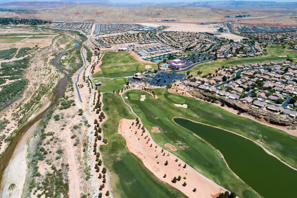
An aerial view of the Sun River Golf course and housing community built alongside the Virgin River at the southern edge of St. George, Utah. Photo by Ted Wood.
Getting Answers
Survey data were collected by the Utah-based market research firm Dynata, hired based on their reputation and reasonable cost quote. Employees of this company randomly selected residents of Washington County to contact for a phone survey and received responses from 400 of them. Respondents represented a balanced range of ages, gender, household income levels and length of time they had lived in Washington County. The results presented below have been weighted slightly by Dynata to best reflect the actual demographic makeup of the county.
Knowledge is lacking
Of the 400 people surveyed, nearly a quarter (22%) said they had never heard of the Lake Powell Pipeline, despite the fact that this is a decades-old project that will have major financial and lifestyle implications for all Washington County residents. 35% felt they “knew a little about it” and 12% felt they “knew a lot about it.” Only 52% of those surveyed said they felt they knew enough about the project to have an opinion on it.
Support is high
Support for the project outweighed opposition to it, with 59% expressing some level of support for it and 35% expressing some level of opposition to it. A majority held relatively mild views on the project, but 35% of all respondents were “very supportive” and 19% were “very opposed.”
But few want to pay
This high level of support, though, did not carry through to a willingness to help fund the project, which has been estimated to cost anywhere between $1.1 and $2.4 billion, to be initially bankrolled by the state and then repaid over 50 years by Washington County residents. In fact, some already-implemented increases in impact fees, property taxes and water rates are currently being put towards project expenses. The WCWCD estimates that the state has already spent around $40 million on planning costs and feasibility studies.
Only 40% of survey respondents answered yes to the question of whether, “knowing what you do about the project, and that the pipeline is proposed as a way to address potential water shortages in the future, are you willing to help fund it, either through increased water rates, higher taxes, or higher fees charged for new water hookups.” 44% answered no to that question and 15% declined to answer.
Among that 40% of people willing to help fund the project, just 8% said they would pay anything more than $50 per month in fees for it, though some estimates suggest the actual cost may be much higher than this. 22% of those who initially answered both that they supported the project and would be willing to help fund it then said that they would not be willing to contribute anything or refused to answer a question about specific amounts.
Overall, then, 50% of all surveyed residents indicated at some point — either in response to the initial funding question or when asked about specific amounts — that they would not be willing to contribute financially to the project at all, despite the fact that some fees are already being collected county-wide to support it. An additional 18% of all those surveyed said that they were unsure about contributing or refused to answer the question. Less than 1% were willing to pay amounts in the highest tier.
Instead, they show a willingness to conserve
In 2011, the Utah Division of Water Resources submitted a 256-page study to the Federal Energy Regulatory Commission detailing how their water needs assessment justified pursuing the Lake Powell Pipeline project. In it, they outline how much water conservation they determined was “feasible for this area based on local conditions, development types, cost and public acceptance.” Conservation options that were considered but not deemed feasible to adopt included turf removal and some appliance rebates.
Survey results, however, indicate perhaps an increased willingness over the past decade to voluntarily adopt stricter water conservation measures.
When asked if they would be “willing to adopt any conservation practices in your own home or accept fewer amenities in your community if it would help avoid construction of the project,” 63% of survey respondents said they would, including 48% of those who had expressed support for the project. Only 26% said they would not be willing to conserve more water and 11% said they didn’t know.
Specific measures respondents said they would be willing to adopt included high levels of support for conservation measures previously ruled out by state and local officials as conflicting with Utah’s traditional cultural values:
75% of people who were amenable to conserving more water said they would reduce the size of their lawn.
88% were willing to take shorter showers.
75% were in favor of requiring desert-friendly landscaping in new housing developments.
67% thought we should stop building water features in parks and public places.
83% would support scaling back lawns in public places or on golf courses.
78% would be willing to update their home appliances.
76% supported increasing water rates/accelerating a tiered pricing structure.
Over the next several weeks, The Spectrum & Daily News will be publishing additional stories in this series examining these survey responses in more detail. Watch for an in-depth look at the finances behind the Lake Powell Pipeline and a breakdown of water conservation attitudes.
Summary
Overall, results of our independent survey indicate that Washington County residents generally support the idea of the Lake Powell Pipeline project despite feeling that they don't know much about it. But few want to contribute to it financially and instead they expressed a greater willingness to adopt new water conservation practices than has previously been recognized.
The people of Washington County have spoken.
Mara Carabello, a public relations specialist working with Gene Shawcroft at Utah’s Colorado River Authority put it this way:
“Letting the desert blossom like a rose has been Utah’s mantra for 200 years. We have such an interesting appetite [for green spaces] in Utah. We've got to start changing how we think of ourselves and how we think of this land.”
Joan Meiners is an Environment Reporter for The Spectrum & Daily News through the Report for America initiative by The Ground Truth Project. Support her work by donating to these non-profit programs today. Follow Joan on Twitter at @beecycles or email her at jmeiners@thespectrum.com.
The Water Desk’s mission is to increase the volume, depth and power of journalism connected to Western water issues. We’re an initiative of the Center for Environmental Journalism at the University of Colorado Boulder. The Water Desk launched in April 2019 with support from the Walton Family Foundation. We maintain a strict editorial firewall between our funders and our journalism.
Some of the snowmelt flowing in the Blue River as it joins the Colorado River near Kremmling, Colo., will reach the Lower Basin states. Dec. 3, 2019. Credit: Mitch Tobin, the Water Desk
Fifteen years ago, deeply worried that a continued drought on the Colorado River would cause a crisis sooner rather than later, the seven U.S. states that share the river’s flows made a historic agreement to jointly manage reservoirs and share shortages that might arise.
The agreement, known in shorthand as the 2007 interim guidelines, is set to be renegotiated beginning this year, ahead of its expiration in 2026.
Another critical set of agreements, known as the 2019 drought contingency plans, are also being re-examined this year as the crisis on the river deepens.
“We’re about to engage in some very difficult discussions,” said Rebecca Mitchell, director of the Colorado Water Conservation Board and the state’s representative on the Upper Colorado River Commission.
Mitchell’s comments came Jan. 26 at the annual convention of the Colorado Water Congress, which represents hundreds of Colorado water users and utilities, in Aurora.
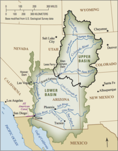
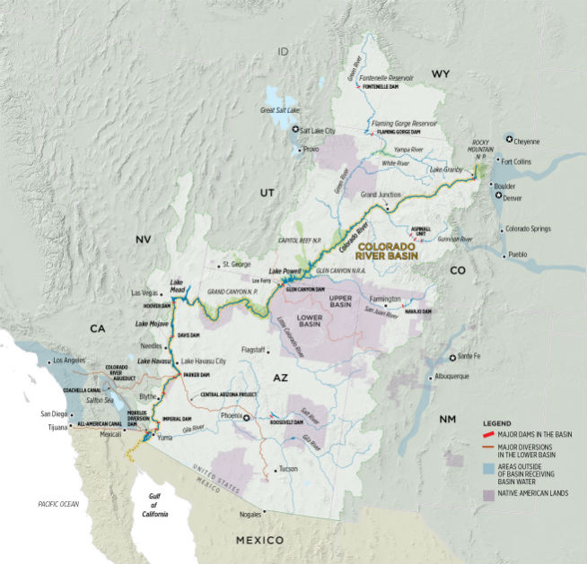
The Colorado River Basin includes the Upper Basin states of Colorado, New Mexico, Utah and Wyoming, and the Lower Basin states of Arizona, California and Nevada. It also includes 30 tribal nations and Mexico.
“One of the keys to our success is going to be that we are in line with the other basin states and the U.S. Department of the Interior, but that we are also working with other sovereigns and stakeholders to find solutions,” Mitchell said.
Mitchell and others credit the two agreements with keeping the system operational for much of the past 15 years.
“They were successful in that they slowed down the decline of the reservoirs and bought some time to see if hydrology improved,” she said. “News flash: It did not.”
Climate change, the 20-year megadrought affecting the basin, and population growth have super-charged the crisis, causing the river’s flows to decline faster than anyone anticipated, and lakes Mead and Powell to record their lowest levels since they were built, respectively, in the 1930s and 1960s.
The river system has deteriorated so quickly that last July the U.S. Bureau of Reclamation moved, within a matter of days, to begin emergency releases of water from Utah’s Flaming Gorge, Colorado’s Blue Mesa, and New Mexico’s Navajo reservoirs.
The goal was to protect Lake Powell’s ability to produce hydropower, a green source of electricity that supplies more than 50 cities and electric companies in Colorado alone.
In addition, Lower Basin states have committed to reducing outflows from Lake Mead, a move that reduces some of the pressure on Lake Powell to the north. But few believe these actions will be enough to protect the river system as the weather forecast continues to deteriorate.
The majority of the mountain snows that feed the Colorado River fall in the Upper Basin. Although recent conditions have improved slightly, with snowpack reaching average or above average levels in the western half of Colorado, climate scientists say the runoff forecast is not matching up and attribute lower forecasts to the impact of badly depleted soil moisture caused by prolonged drought.
That has left Upper Basin state water officials wondering how much more water they will have to sacrifice to protect Lake Powell.
“The Secretary of Interior took action to release 150,000 acre-feet of water from Upper Basin reservoirs to protect Lake Powell levels. 36,000 acre-feet of that came from Blue Mesa. It left that unit at 27% full. We saw the harm that caused,” Mitchell said. “It’s difficult to think how much more we can provide.”
Lain Leoniak, an attorney and negotiator from the Colorado Attorney General’s office, said officials are hopeful that the new interim guidelines will contain a road map that hinges less on operating rules and more on weather forecasts.
“We’re going to have to find a way to be responsive to extreme variability in hydrology,” Leoniak said. “We need flexibility built into any post-2026 guidelines, but we don’t want to be engaging in renegotiations every two to three years. That doesn’t work either.”
As teams from across the basin prepare to begin negotiating, Mitchell said Colorado and other Upper Basin states would push to ensure that no one state has to take on more of the burden than another, that all states, and such sovereign nations as the tribal nations and Mexico, as well as other parties, such as environmental groups, would be full participants in the negotiations.
Mitchell also said her negotiating team would push to ensure the Upper Basin states weren’t forced to give up more water than the downstream users on the system.
Under the terms of the 1922 Colorado River Compact, the Upper Basin and Lower Basin states are each entitled to 7.5 million acre-feet of water annually. But any excess water received, or left unused, in the Upper Basin flows to the Lower Basin because much of it cannot be stored here. That situation has given Lower Basin states access to surplus water over the years that they have become reliant on, a fact that Mitchell and others say has to change if the river is going to be brought into balance in this drier world.
“The compact’s intention was that we all had that equal footing. The fact that there have been states that have been able to overuse while we are using less than our apportionment … we don’t want them to get used to that overuse. We have to be focused on making sure that they adjust to what is available to them,” Mitchell said.
As the 1922 compact approaches its 100th anniversary in November, Mitchell said she was hopeful that agreements will be reached in the coming months that will help balance the river and allow it to function well for the next century.
“Hopefully people will be sitting here in 100 years saying [of the negotiators], ‘They did a good job.’”
Jerd Smith is editor of Fresh Water News. She can be reached at 720-398-6474, via email at jerd@wateredco.org or @jerd_smith.
Fresh Water News is an independent, nonpartisan news initiative of Water Education Colorado. WEco is funded by multiple donors. Our editorial policy and donor list can be viewed at wateredco.org.
The Water Desk’s mission is to increase the volume, depth and power of journalism connected to Western water issues. We’re an initiative of the Center for Environmental Journalism at the University of Colorado Boulder. The Water Desk launched in April 2019 with support from the Walton Family Foundation. We maintain a strict editorial firewall between our funders and our journalism.
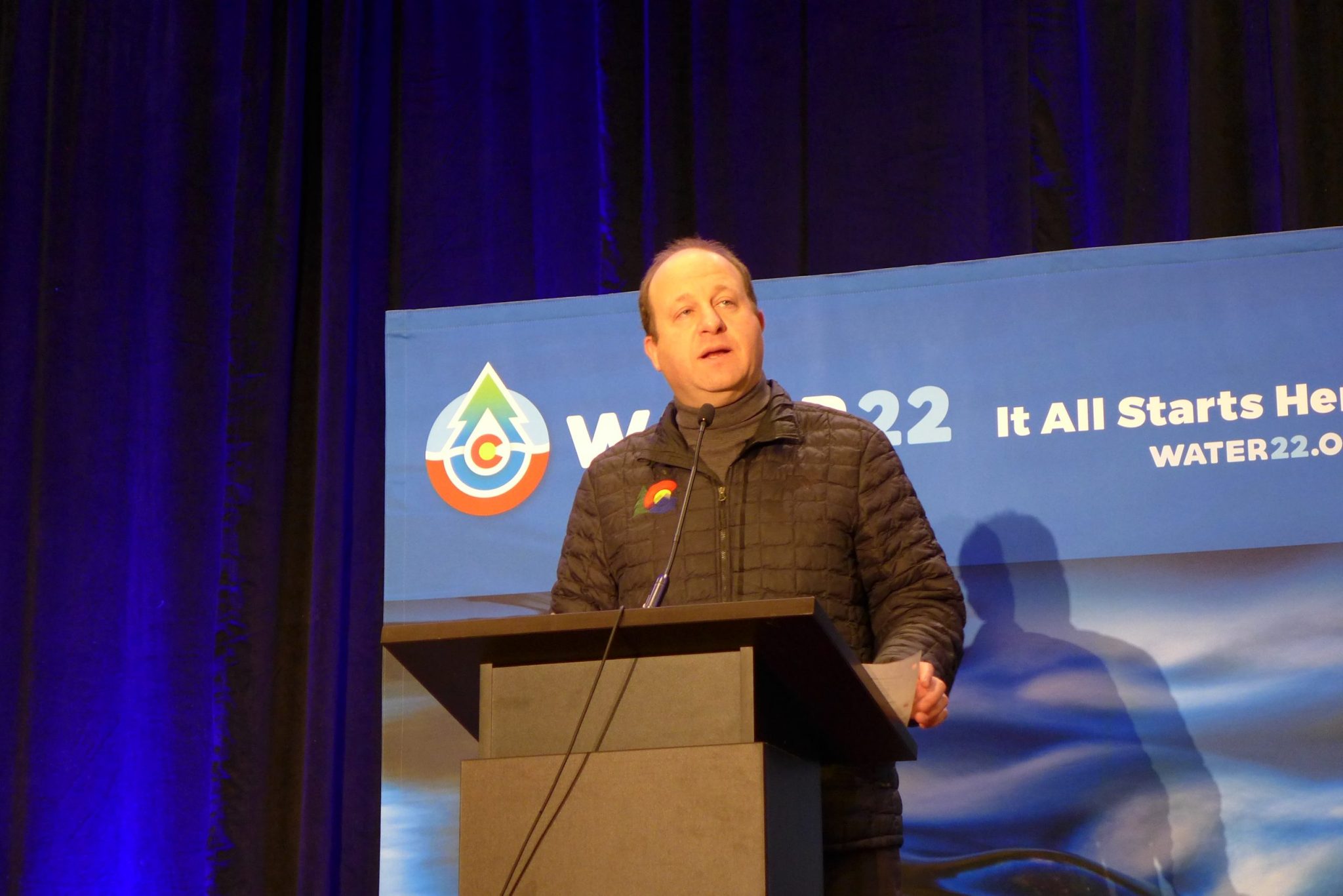
Gov. Jared Polis on Wednesday announced Water ’22, a campaign to encourage individual consumers to conserve water with 22 simple steps. Despite a climate tie-in the initiative is partly funded by a fossil fuel company. CREDIT: HEATHER SACKETT/ASPEN JOURNALISM
AURORA — State officials on Wednesday announced an education campaign aimed at water conservation that emphasizes the role of individual consumers in their everyday, in-home water use.
At the bi-annual meeting of the Colorado Water Congress, Gov. Jared Polis unveiled the Water ’22 campaign, a year-long, statewide initiative that aims to educate Coloradans about one of the state’s most important resources. The program encourages conservation in the face of climate change-fueled drought by asking people to take a pledge to conserve water and protect water quality in their daily lives by taking part in 22 small actions.
Polis proclaimed 2022 the “Year of Water” in Colorado, marking the 100th anniversary of the Colorado River Compact and an upcoming update to the state’s 2015 Water Plan.
“We have a shared responsibility to steward this incredible natural resource and make sure it’s there for our people, our places, our ecosystems, our industries that need it to thrive because it all starts here in Colorado with us,” he said.
Water ’22, which is being spearheaded by Water Education Colorado, lays out 22 simple things individuals can do to save 22 gallons of water a day. They include things like turning off the water while brushing your teeth, fixing leaky fixtures, watering outdoor lawns and landscaping at dawn or dusk and using phosphorus-free fertilizer. The initiative is an effort at education and engagement and is not designed to result in measurable water savings or improvements to water quality.
The campaign focuses on the voluntary actions of individual municipal water customers instead of policy changes to conserve water. And although the agriculture industry represents 86% of the state’s water use, according to numbers provided by Water Education Colorado, Water ’22 does not include ways for agriculture to conserve water.
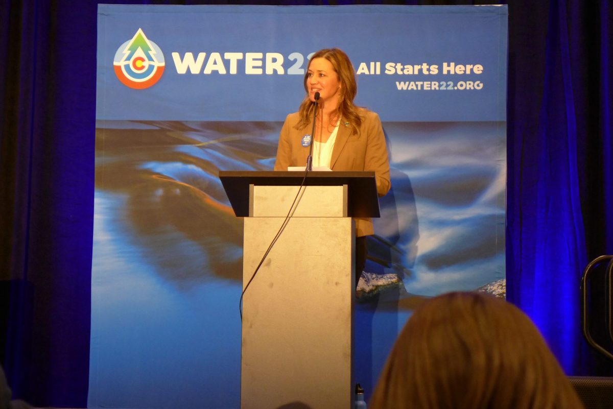
“The main thrust of the campaign is targeting consumers at the domestic-use level,” said Jayla Poppleton, executive director of Water Education Colorado. “Our message to Coloradans is that they have a role to play. It’s up to all of us to do our part.”
According to its website, Water Education Colorado is a nonprofit organization charged with ensuring a sustainable water future by educating and engaging citizens around water. It also publishes the Fresh Water News website.
But focusing on individual actions instead of larger policy changes to conserve and protect water is problematic, said Gary Wockner of conservation group Save the Colorado, whose mission is to protect and restore the Colorado River and its tributaries.
“We have a very serious concern that the Polis administration, in collusion with corporate interests, is trying to place the blame for the water supply chaos onto residents rather than make substantial changes to Colorado water law,” Wockner said.
Jayla Poppleton, executive director of Water Education Colorado speaks at Colorado Water Congress at the announcement of the state’s new campaign Water ’22. The initiative is focused on individual actions and is not designed to result in measurable water savings.CREDIT: HEATHER SACKETT/ASPEN JOURNALISM
Sponsors and supporters
Water ’22 promotional materials highlight the connection between climate change, drought, wildfires and water shortages.
“The Water ’22 campaign was created to educate Coloradans about how the state’s water is one of its most important resources and to encourage conservation and protection in order to mitigate the impacts of climate change, which has led to persistent drought conditions,” reads a press release.
There is no doubt climate change is robbing the Colorado River of water and driving shortages.
Scientists Brad Udall and Jonathan Overpeck showed in a 2017 paper that rising temperatures are responsible for roughly one-third of declining flows. Hot temperatures and dry soils have contributed to record-low spring runoff in recent years and the basin’s two largest reservoirs — lakes Powell and Mead — stand at less than one-third full, their lowest levels ever. In 2021, federal officials declared the first-ever shortage in the lower basin and began emergency releases from upper basin reservoirs to prop up Lake Powell and maintain the ability to make hydroelectric power.
But despite a focus on climate change-fueled drought, Water ’22 is funded in part by a fossil fuel giant. American oil company Chevron is a sponsor of Water ’22 and has contributed $10,000 toward the campaign, according to Poppleton. Burning fossil fuels like coal, oil and gas is the main driver of climate change.
Other presenting sponsors who have contributed $10,000 to the campaign include Molson Coors Beverage Company and Boulder-based cannabis edibles company Wana Brands. It is also being funded with $35,000 of state grant money from the Colorado Water Conservation Board.
Wockner said there’s no evidence that conservation by domestic water users will result in more water in rivers.
“The conservation does not appear to be protecting rivers, so how does this serve the public’s interest?” he said.
Several environmental organizations prominent in the water sector are also participating in Water ’22. Water for Colorado, which represents a coalition of groups, including The Nature Conservancy, Western Resource Advocates, Audubon Rockies and American Rivers, is supporting it as well.
Water for Colorado Communications Coordinator Ayla Besemer said things in the Colorado River basin are dire and it’s important for Coloradans to know where their water comes from and do all they can to conserve on a personal level.
“Between the destructive wildfires, the first-ever basin shortage declaration, emergency reservoir releases, and ongoing megadrought, the need to support Colorado’s fragile water resources is so urgent as to rise above one, specific donor,” she said, referring to funding from Chevron. “We trust this campaign will have a positive effect on water and Coloradans’ understanding of the current situation, aiding in collaborative efforts to confront climate change.”
Poppleton said Water ’22 is proud to have Chevron, along with its other sponsors, as supporters for the campaign.
The Water Desk’s mission is to increase the volume, depth and power of journalism connected to Western water issues. We’re an initiative of the Center for Environmental Journalism at the University of Colorado Boulder. The Water Desk launched in April 2019 with support from the Walton Family Foundation. We maintain a strict editorial firewall between our funders and our journalism.
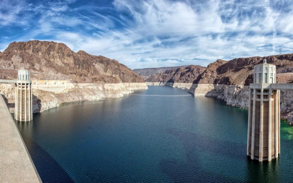
Glen Canyon Dam and Lake Powell, a key Colorado River reservoir that has seen its water level plummet after two decades of drought. (Source: LightHawk Conservation Flying/The Water Desk)
By Douglas E. Beeman
Climate scientist Brad Udall calls himself the skunk in the room when it comes to the Colorado River. Armed with a deck of PowerPoint slides and charts that highlight the Colorado River’s worsening math, the Colorado State University scientist offers a grim assessment of the river’s future: Runoff from the river’s headwaters is declining, less water is flowing into Lake Powell – the key reservoir near the Arizona-Utah border – and at the same time, more water is being released from the reservoir than it can sustainably provide.
Udall’s slides and charts suggest that unless something changes soon, water levels behind Lake Powell’s Glen Canyon Dam on the Arizona-Utah border may fall so low by 2025 or 2026 that no water can get past the dam. That could ultimately leave downstream states like California, Nevada and Arizona short of water promised under the century-old Colorado River Compact that divided the river’s waters between the upper and lower watersheds.
And that has the potential to set up something that many water interests on the river say they want to avoid – a so-called “Compact call.” Such a scenario could force the Upper Basin states – Colorado, New Mexico, Utah and Wyoming – to curtail their own water use to fulfill their Compact obligation to send a certain amount of water to the Lower Basin states of California, Arizona and Nevada.
“There is a need for speed in reaching some sort of agreement to share the reduced flows of the river.” ~Anne Castle, former assistant secretary of the Interior for Water and Science
There has never been a Compact call on the river. But as evidence grows that the river isn’t yielding the water assumed by the framers of the 1922 Colorado River Compact, questions arise about whether a Compact call may be coming, or whether the states and water interests, drawing on decades of sometimes difficult collaboration, can avert a river war that ends up in court. It’s no small matter for a river that serves water to 40 million people from Denver to Los Angeles and irrigates more than 4 million acres of crops. The growing risk and the difficult actions that might be necessary to avoid a Compact call have been hot topics of discussion at several recent Colorado River conferences.
“The temperature, metaphorically, seems to be rising,” Anne Castle, a former assistant secretary of the Interior for Water and Science and a Colorado River veteran, said in an interview. “There is a need for speed in reaching some sort of agreement to share the reduced flows of the river.”
A River in Trouble
Without question, the Colorado is a river in trouble. After more than two decades of drought, both of the river’s anchor reservoirs – Lake Powell, upstream of Lee Ferry (the dividing point between the Upper and Lower Basins), and Lake Mead, the nation’s largest reservoir located downstream of Lee Ferry near Las Vegas – are only about 30 percent full. The river’s Rocky Mountain watershed has begun to see snow this winter, but many more rich winters of storms would likely be needed to undo 22 years of drought.
Chart: Water Education Foundation Source: US Bureau of Reclamation
In August, the Bureau of Reclamation declared a first-ever shortage for next year, requiring Arizona and Nevada to cut back their annual take of the river by a total of 533,000 acre-feet (a cut of about 17 percent, mostly from Arizona) beginning this month. Based on a 2017 agreement, Mexico also will reduce its draw from the river. The move is intended to prevent already dire water levels from falling further in Lake Mead. Meanwhile, Reclamation’s most recent 24-month operating plan projects that, if hydrology remains extremely dry, the water level in Lake Powell by next September could approach the minimum needed to keep the hydropower turbines running.
Lake Mead, which serves as a key Colorado River reservoir for the Lower Basin, holds just a third of its capacity due in part to a two-decade drought. (Source: Southern Nevada Water Authority)
Under a set of river operating guidelines adopted in 2007, the two reservoirs are managed in tandem, with Powell releasing water to help prop up water levels at Lake Mead. That arrangement has sometimes frustrated water interests in the Upper Basin, who have at times complained that the Lower Basin is using too much water and that their own ambitions for developing the river are being stymied.
“The level of Mead dictates in part how much water is released from Powell,” Becky Mitchell, the state of Colorado’s top water official, said at a recent water conference. “It’s important to focus on what’s going out of Lake Mead, because that has the greatest impact on the [Colorado River] system.”
Brad Udall, Colorado State University climate scientist who warns of trouble ahead for the Colorado River Basin because of a hotter, drier climate. (Source: Colorado State University)
When commissioners from the seven Basin states gathered in 1922 to hammer out the Compact – the foundational document in a growing set of agreements, laws and court cases called the Law of the River – they believed the river routinely carried about 17.5 million acre-feet a year. On that belief, they apportioned 7.5 million acre-feet a year each to the Upper and Lower Basins. They also agreed that any water committed to Mexico by a later U.S. treaty would be supplied equally by the two Basins. Native American tribes, who are now acknowledged to hold substantial rights to the river’s water, were barely mentioned.
But more recent Bureau of Reclamation data show river flows averaged just 12.3 million acre-feet annually from 2000 to 2021 as severe drought gripped the river basin. Udall, the veteran Colorado State University climate researcher, said at an October conference that a warming climate that is drying out the Basin is making things worse. From 2000 to 2014, he estimates, hotter temperatures reduced Colorado River flows by about 6 percent. That’s on top of reductions just from less rain and snow. By 2050, Udall said, with a continuation of the current precipitation decline the hotter temperatures could reduce runoff by 30 percent and those losses could reach 45 percent — or more — by 2100.
Udall, speaking at the annual conference of the Getches-Wilkinson Center at the University of Colorado Boulder, said releases from Lake Powell to meet the Upper Basin’s obligation to downriver users coupled with evaporative losses exceed what is flowing into Powell. That, he added, is not sustainable.
“The Upper Basin is headed to a Compact issue with the Lower Basin here at some point in time if those flows continue,” Udall said.
The Green and Colorado rivers cut through Utah’s Canyonlands National Park. A warming climate is adding to the drought-driven declines in snowmelt and spring runoff across the Colorado River Basin. (Source: LightHawk Conservation Flying/The Water Desk)
Risks of a Compact Call
No one knows exactly how a Compact call would work or who would set it in motion since it has never happened before. A 1948 agreement — the Upper Colorado River Basin Compact — places the responsibility for deciding how to divide any water use reductions among the states on the Upper Colorado River Commission, made up of representatives from the four Upper Basin states and one federal government representative. The commission’s responsibilities include making sure the Upper Basin meets its obligations under the 1922 Colorado River Compact.
Colorado, considered one of the headwaters states and holding the largest river apportionment in the Upper Basin, would likely feel the greatest pain from any Compact call, said Castle, the former Interior Department official, now a senior fellow at the Getches-Wilkinson Center at the University of Colorado School of Law.
Anne Castle, the former assistant Interior secretary and a veteran of Colorado River issues. (Source: Water Education Foundation)
Castle and writer John Fleck, at the University of New Mexico, wrote a 2019 paper looking at the risk of a Compact call, or a “Compact curtailment” as they called it. Their basic conclusions: The risk is substantial, there are options for compromises that could reduce that risk, and a so-called “demand management” program, where willing participants could be compensated for using less water, could lessen the potentially devastating risks that a forced curtailment of Colorado River water would have on users.
In an interview, Castle said at its worst, a Compact curtailment could pare back Colorado’s water use to levels that existed before the Compact was signed in 1922. Denver, which reaches across the Continental Divide to tap the Colorado River for its residents, could lose half of the city’s supply. That’s unrealistic, Castle said, adding that in that case Denver would likely seek out farmers with higher-priority water rights and cut deals to use their water to meet the city’s needs.
Doug Kenney, a longtime Colorado River researcher at the University of Colorado Boulder, said the Upper Basin is getting caught in a squeeze: As river flows shrink and the Lower Basin continues to draw on its 7.5 million-acre-foot annual apportionment, less water is available for the Upper Basin. A primary objective of the 1922 Colorado River Compact was to equitably divide the river’s waters, Kenney said.
“You cannot talk about Compact calls,” he said, “and be true to the spirit of what the agreement is all about.”
The Green River, one of the drought-stressed tributaries that flows into the Colorado River. (Source: LightHawk Conservation Flying/The Water Desk)
Addressing A Shrinking River
Getting to an agreement to resolve the river’s declining hydrology is unlikely to be easy. As drought and climate change dry the river basin and rob it of runoff, water interests in the Upper Basin states argue that they shouldn’t have to absorb the full impact of those declining river flows. They say Upper Basin states have been absorbing water shortages for years as the upper watershed dries out, while the Lower Basin continues to use water at a rate that’s drying out both major reservoirs. They say those declines should be shared equitably between the Upper and Lower Basins and that the Lower Basin should reduce its use of the river’s water that has contributed to the drawdown of water levels in lakes Powell and Mead.
Becky Mitchell, the state of Colorado’s top water official. (Source: Colorado Water Conservation Board)
Mitchell, Colorado’s top water official, argues that the two reservoirs – which are among the nation’s largest – provide the Lower Basin certainty and security for water deliveries. The Upper Basin states don’t have a big reservoir higher up in the watershed to provide the same kind of certainty about their water supplies, she told a Congressional hearing in October. Instead, the Upper Basin states rely primarily on runoff from annual snowpack, she said, and when the snow is thin, the water runs short.
At the same time, some Upper Basin water officials argue that they should be free to develop more projects that could allow them to use more of the water that was apportioned to them by the 1922 Colorado River Compact. Utah, for example, has been pursuing a $2 billion pipeline project to bring water from Lake Powell to fast-growing communities like St. George in southwestern Utah.
State Engineer John D’Antonio, New Mexico’s top water official until his retirement last month, is one who believes Upper Basin states shouldn’t be precluded from developing future water projects based on low river projections. In some years, he told participants at the Getches-Wilkinson Center’s conference in October, water managers might find they have the water they expected for a project, “but with the understanding that we still have to manage within our respective base.”
The Colorado River winds 1,450 miles from mountaintop to sea in a basin that includes seven American states and two Mexican states. (Source: U.S. Geological Survey)
In the Lower Basin, state officials and water interests acknowledge that river flows are shrinking and reductions in use are necessary. In recent years, Lower Basin water interests have pared back their take of river water as they’ve watched levels in Lake Mead plummet. In December, they took more action: At the Colorado River Water Users Association meeting in Las Vegas, officials from California, Arizona and Nevada and the Bureau of Reclamation signed a two-year, $200 million agreement that promised to conserve an additional 500,000 acre-feet a year that would remain in Lake Mead. Half of the money would come from the federal government, with the rest split by water agencies in the three states.
But they chafe at the notion of the Upper Basin expanding its draw on the river when shrinking flows suggest more should be done to conserve what remains.
“If the goal is to get the Basin to equilibrium, where our uses are taking out of the river what we can reasonably expect the river to deal us over the next several decades, then reducing overuse while increasing new uses isn’t going to get you to that equilibrium,” John Entsminger, general manager of the Southern Nevada Water Authority, told the audience at the Getches-Wilkinson Center’s conference in October.
A Sense of Urgency
The shrinking hydrology and the simmering tensions between the Upper and Lower Basins come at a precarious time for states and water interests along the Colorado River. The key set of interim guidelines for river management, in place since 2007, are due to expire in 2026. Water-related interests – including water agencies, states, Native American tribes and nongovernmental organizations – are preparing to work out a new set of operating guidelines to guide river management and address shortages. But impacts of drought and climate change may force them to act sooner.
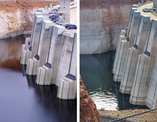
Lake Powell’s decline is seen in these photos of Glen Canyon Dam taken a decade apart. On the left, the water level in 2010; on the right, the water level in 2021. (Source: Bureau of Reclamation)
At December’s Colorado River Water Users Association, an annual Las Vegas gathering of key Colorado River water interests, there was a grim sense of urgency to address the river’s needs.
“Climate change is real. We need to take innovative, proactive measures to address the effects here in the Colorado River Basin and throughout the West,” Tanya Trujillo, the Interior Department’s assistant secretary for water and science, told the group.
Although water interests in the Basin have sometimes turned to the courts to resolve disputes, Jeff Kightlinger, the former general manager for Metropolitan Water District of Southern California and a veteran of many of the Colorado River’s complex agreements over two decades, said in an interview that water interests from the Upper and Lower Basins have proven repeatedly that they can find common ground. He cited the 2007 Interim Guidelines that guide river operations, the 2017 Minute 323 agreement with Mexico that included conservation measures, and the 2019 Drought Contingency Plans as examples.
“The best result is when we stop suing each other,” Kightlinger said. “Hopefully we can stick to that model. It’s going to be hard.”
But he acknowledged that finding common ground now is likely to be more difficult given the shrinking river and declining reservoirs. When the drought started in 2000, Lake Powell and Lake Mead were nearly full, so water interests had space and time to work out agreements. “The hard part is there is no cushion anymore,” he said, “so now we’re working without a net.”
The possibility that the courts may be asked to settle how the shrinking river should be shared hangs in the background. Kenney, the veteran Colorado River researcher who recently retired from the University of Colorado Boulder, said there’s been an unwritten understanding that differences in the Basin would be settled in the conference room, not the courtroom. The Upper Basin’s fear, he said, has been that they may end up worse off in court than at the negotiating table. But as their own water resources get squeezed to bolster water levels in Lake Mead, Kenney said, the Upper Basin may decide they’re no worse off making their case in court.
Yet key water managers in the Upper Basin say litigation is an outcome they hope to avoid. Mitchell, the Colorado water manager, said avoiding litigation is among the principles that guide her state’s approach to renegotiating the 2007 river operating guidelines.
Among the other principles, she told the Hutchins Water Center’s virtual November conference in Grand Junction, Colo.: Provide additional water supply security and certainty for Colorado and throughout the river basin, improve operations of lakes Powell and Mead and avoid curtailment of water uses in the Upper Basin.
Meanwhile, Mitchell said, the Upper Basin states are continuing to investigate the feasibility of a conservation effort called demand management that would compensate water users that are willing to temporarily use less water.
Eric Kuhn, a retired Colorado water manager and co-author with John Fleck of a book on the 1922 Colorado River Compact, said that while science is pointing to an accelerated decline in river flows, there are things the Upper Basin can do to have a robust economy and still conserve water. Coal-fired power plants are closing, which should free up water, he told an audience at the Getches-Wilkinson Center conference in October, and reductions in turf – both in cities and on farmland – can add to conservation.
“We can do some really, really good things in this Basin for the economy and our quality of life and still use less water,” he said.
Adapting Intelligently
In the Lower Basin, some water managers and Colorado River veterans believe the water users in Arizona, Nevada and California may have to cut their draw of the river by 1.5 million acre-feet. Entsminger, Southern Nevada’s general manager, said his agency is updating its 50-year water resource plan that anticipates the Colorado River’s annual supply will average just 11 million acre-feet instead of the 15 million acre-feet that was divided between the Upper and Lower Basins by the 1922 Compact.
“We’ve just got to be better at being able to adapt intelligently.” ~Chris Harris, executive director of the Colorado River Board of California
Chris Harris, executive director of the Colorado River Board of California, the state agency established in 1937 to protect California’s rights and interests on the Colorado River, said water interests throughout the river basin are likely pondering a range of possible river flows. Harris said California and other Basin states will need to be flexible and adapt to whatever the river gives.
“We’ve just got to be better at being able to adapt intelligently,” Harris said.
The Imperial and Palo Verde irrigation districts in Southeastern California hold some of the earliest significant rights to the river’s water along with Native American tribes. While California is protective of its “very senior” water rights, Harris said California water users have demonstrated in the past that through collaborative agreements and partnerships, they can conserve significant water supplies on farms and in cities. And while Upper Basin water officials talk about their own water shortages as they send supplies downriver, Harris said California has been coping with drought and managing water shortages for decades. In response, he said, the state has improved water supply infrastructure and implemented conservation measures to stretch its supply.
“Hydrologic shortages are not an anomaly or an aberration in one basin or the other. They’re occurring in every state,” Harris said. “We are all dealing with a new water supply reality.”
A two-year agreement signed in December by Reclamation and water agencies in California, Nevada and Arizona committed up to $200 million for water conservation measures, including for crop fallowing on farms. Some farm areas are reluctant to embrace fallowing because of its community impacts. (Source: Water Education Foundation)
The two-year agreement signed in December by Reclamation and water agencies in California, Nevada and Arizona that committed up to $200 million for water conservation measures included money for crop fallowing on farms and urban conservation measures. Some of the conservation measures have yet to be identified. The goal is to keep 500,000 acre-feet a year in Lake Mead. Separately, Reclamation signed agreements with Gila River Indian Community and Colorado River Indian Tribes to conserve 134,250 acre-feet of water in Lake Mead. An acre-foot is about 326,000 gallons, or enough water to serve two to three households for a year.
Kightlinger, the former Metropolitan Water District general manager, believes the Lower Basin may have to reduce its draw on the Colorado River by 1.5 million acre-feet a year. Still, he added, it doesn’t all have to be done at once and it might not all involve cuts. Additional ocean desalination or wastewater recycling, he said, could help grow the pot of water. Lower Basin interests may be able to develop a 25-year plan with targeted water savings and benchmarks to measure progress. Such a reduction plan would surely include participation from agricultural water users, he said. “There’s no way to come up with that kind of number absent a strong ag participation,” Kightlinger said.
Metropolitan Water District has done partnerships in the past with agricultural water districts like Imperial and Palo Verde irrigation districts for conservation improvements or compensated land fallowing. In December, the district signed yet another partnership, a seasonal land fallowing agreement with the Quechan Tribe of the Fort Yuma Indian Reservation to conserve up to 3,500 acre-feet of Colorado River water.
Kightlinger said such agreements for farm water conservation can be done in a way that works for farmers and agricultural communities. “There’s more cooperation out there than people realize,” he said.
Tina Shields, Imperial Irrigation District’s water department manager, said her agency generally doesn’t support farmland fallowing because of the economic impacts to the community in lost jobs and support service revenues. But the agency does implement large-scale agricultural and on-farm efficiency-based conservation programs and believes there’s room for expansion. “We’re conserving a half-million acre-feet a year already,” she said.
Tina Shields, Imperial Irrigation District water manager. She said her agency has implemented water efficiency improvements for farms, but does not support fallowing as a conservation measure. (Source: Water Education Foundation)
But there are complications. One is that the district has limited options to store saved water, Shields said. The 1931 agreement that apportioned California’s share of the river gave Metropolitan Water District an exclusive right to store the state’s water in Lake Mead. More recent agreements have given IID the ability to store a modest amount of water in Lake Mead and a somewhat larger amount within Metropolitan’s system off-river, she said, but those savings accounts are full. Imperial is now partnering with Metropolitan to store another 50,000 acre-feet of conserved water in Lake Mead under Metropolitan’s account – still a tiny amount compared to Imperial’s 3.1 million-acre-foot river entitlement – and is discussing partnerships with both Metropolitan and the Bureau of Reclamation to store even more conserved water in the lake.
Another complication, Shields said, is the impact that any additional conservation has on the Salton Sea, California’s largest inland lake. Earlier water-saving agreements resulted in less farm runoff flowing to the sea. The district compensated with mitigation flows to the sea, but since those ended in 2017 the sea has been receding, creating the potential for unhealthy dust clouds from its newly exposed shoreline and rising salinity to levels that can no longer support the sea’s fishery and bird communities. The state of California is working on a 10-year restoration plan for the sea. But any further water conservation effort by Imperial Irrigation District, she said, will need to account for impacts of reduced farm runoff going to the Salton Sea – and require help from state and federal agencies.
Avoiding the Supreme Court
Across the entire Basin, there is an undercurrent of concern that as water interests try to work out an equitable solution between the Upper and Lower Basins, their lawyers are preparing legal arguments in case their interstate differences land them before the U.S. Supreme Court.
Harris, with the Colorado River Board of California, said he believes there’s a willingness and commitment to do anything and everything to avoid going to the Supreme Court.
“If you end up in the United States Supreme Court, isn’t that just a bald-faced acknowledgement of failure?” asked Harris.
At the Getches-Wilkinson Center conference in October, members of a panel titled “Time to Get Real” were asked how the Upper and Lower Basins could get beyond the legal jousting over who should get how much of the river’s waters.
Entsminger, Southern Nevada’s general manager, offered a note of concern over whether water interests in the two basins are up to the challenge of reaching an equitable solution in the face of climate change.
If this winter or the next one is as dry as last year, and the two basins cannot work together to find solutions to the river’s woes, he said, “Mother Nature is going to pick the winners and losers. And she’s going to do it really quick.”
“So we can keep shadow boxing about who’s feeling more pain, or who should have done what over the last 20 years or over the last 100 years,” he added. “Or we can come to the table and come up with a plan to use the amount of water the river’s actually going to give us.”
Further Reading From Western Water
As Climate Change Turns Up The Heat in Las Vegas, Water Managers Try to Wring New Savings to Stretch Supply, June 25, 2021
Milestone Colorado River Management Plan Mostly Worked Amid Epic Drought, Review Finds, Nov. 20, 2020
The Colorado River is awash in data vital to its management, but making sense of it all is a challenge, Sept. 11, 2020
Questions Simmer About Lake Powell’s Future As Drought, Climate Change Point To A Drier Colorado River Basin, May 15, 2020
Can a Grand Vision Solve the Colorado River’s Challenges? Or Will Incremental Change Offer Best Hope for Success? Dec. 13, 2019
With Drought Plan in Place, Colorado River Stakeholders Face Even Tougher Talks Ahead On The River’s Future, May 9, 2019
As Shortages Loom in the Colorado River Basin, Indian Tribes Seek to Secure Their Water Rights, Nov. 2, 2018
The Water Desk’s mission is to increase the volume, depth and power of journalism connected to Western water issues. We’re an initiative of the Center for Environmental Journalism at the University of Colorado Boulder. The Water Desk launched in April 2019 with support from the Walton Family Foundation. We maintain a strict editorial firewall between our funders and our journalism.
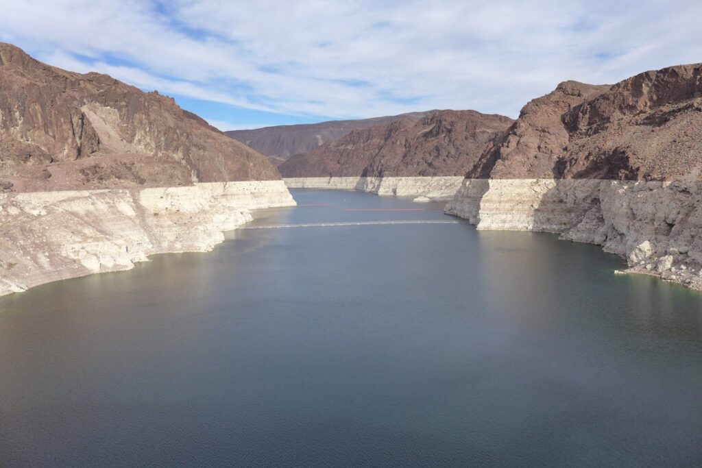
This photo from December 2021 shows the famous “bathtub ring” at Lake Mead due to declining water levels. The lower basin states are planning to save water in the reservoir through the 500 + Plan. Credit: Heather Sackett/Aspen Journalism
By Heather Sackett
Some Colorado River scholars say that a plan by the lower-basin states to leave more water in Lake Mead embodies a principle they explore in a recently published article: Dropping reservoir levels have opened a window of opportunity for water-management policies that move the river system toward sustainability.
In December, water managers from California, Nevada and Arizona signed a memorandum of understanding, or MOU, to spend up to $200 million to add 500,000 acre-feet of water in both 2022 and 2023 to Lake Mead, the nation’s largest reservoir, which has dropped precipitously low due to climate change and drought.
Water managers developed the program, known as the 500+ Plan, in just four months — lightning speed for something that requires the cooperation among — and millions of dollars from — each participant.
Water experts say part of the reason the plan came together so quickly is because it got a push from last year’s record-bad conditions. Water managers have watched reservoir levels in lakes Powell and Mead slowly dwindle for the past two decades, but 2021 was a wake-up call for many. A near-normal snowpack translated to just 31% of normal runoff, which was the second-worst inflow into Lake Powell ever.
“We had no idea how bad 2021 hydrology would be,” said Bill Hasencamp, manager of Colorado River resources for the Metropolitan Water District of Southern California. “We knew it was a dry year, but when it turned out to be 31%, it was an eye-opener.”
It wasn’t until June that water managers realized how bad the situation was, and talks about the 500+ Plan began in August, Hasencamp said. That quick turn-around tracks with the findings of a new article by John Fleck, a writer-in-residence at the Utton Center at the University of New Mexico, and Anne Castle, senior fellow at the Getches-Wilkinson Center at the University of Colorado. Their paper, “Green Light for Adaptive Policies on the Colorado River,” was published in December.
The paper says that frenzied media attention, dramatically dropping reservoirs to their lowest levels ever and the first-ever shortage declaration by federal water managers created an opening for the political will necessary for an innovative solution. Rapidly dropping reservoirs create a “green light” scenario for river management where conditions shift from a situation to be monitored to a problem that needs to be solved.
“That visceral experience we have with low reservoirs and seeing the snowpack not end up in them last year is part of what’s created this moment of opportunity,” Fleck said. “When we look at those reservoirs — which have been our safety for a long time, they have been our security blanket — and they’re gone, you see political leadership lurching to the issue.”
500+ Plan builds on previous work
But since political will can be fickle and fleeting, it’s important that policy solutions — usually the product of years of careful crafting — are ready to be implemented quickly when the timing is right and the “green light” window of opportunity opens. Although formal discussions about the 500+ Plan were only four months long, much of the groundwork had been laid over previous years.
“We know the technocrats behind the scenes, the people working at NGOs and government offices, they are thinking about this stuff and producing policy before we need it so they can attach it onto a problem when a problem arises,” said Elizabeth Koebele, a researcher at the University of Nevada and who studies how government policies get made collaboratively.
The lower basin is taking action after modeling showed that Lake Mead’s surface elevation could drop below 1,030 feet, which is a critical threshold identified in the 2019 Drought Contingency Plan. The reservoir is currently at 1,066 feet elevation.
The basic way the program will work is by municipal water providers paying irrigators to not use water so it can be stored in Lake Mead. It will be funded by $40 million from the Arizona Department of Water Resources; $20 million each from the Central Arizona Project, Metropolitan Water District of Southern California and Southern Nevada Water Authority; and $100 million in matching funds from the federal government.
The 500+ Plan is resonant of the System Conservation Pilot Program, which ran from 2015 to 2018 and paid upper-basin farmers and ranchers to voluntarily fallow fields in order to boost levels in Lake Powell.
“These were ideas they didn’t have to make up from scratch,” Fleck said. “I was amazed at the speed with which (the 500+ Plan) came together. It was very impressive because it built on work that had been going on behind the scenes for a long time.”
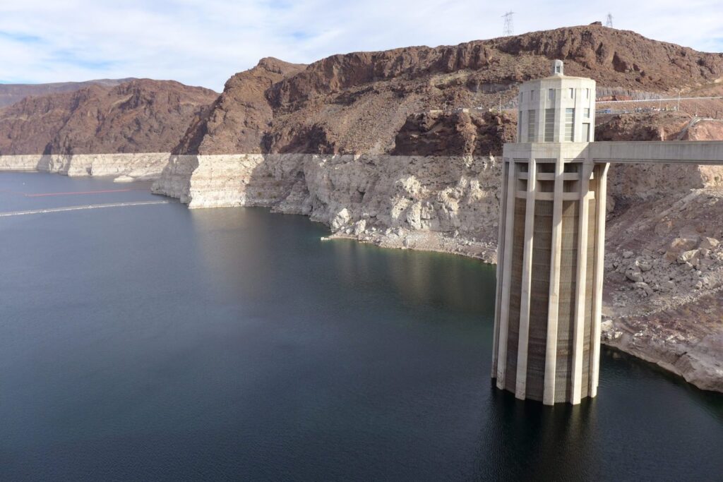
This photo from December 2021 shows one of the intake towers at Hoover Dam. California, Nevada and Arizona recently penned a deal to keep 500,000 acre-feet of water in Lake Mead to boost the declining reservoir levels. Credit: Heather Sackett/Aspen Journalism
Upper-basin lessons?
Although the MOU lays out where the money for the 500+ Plan will come from, the details of where the water will come from are still being worked out, Hasencamp said. Water providers will save water through their existing conservation programs, as well as creative new ones that will be announced soon, he said. The program is likely a stop-gap measure aimed at keeping reservoir levels high enough until new operating guidelines can be negotiated in 2026.
Still, the lower basin’s program could contain lessons for the upper basin — Colorado, Wyoming, Utah and New Mexico — as the four states continue to explore the possibility of their own program to save 500,000 acre-feet, known as demand management. The upper basin, led by Colorado, is investigating the feasibility of temporarily paying irrigators to use less water in order to send water to Lake Powell as an insurance pool against shortages.
With thousands of individual agricultural water users and lingering questions about how to verify water savings, the process is more complicated in the upper basin, and discussions have been slow-moving.
Rebecca Mitchell, director of the Colorado Water Conservation Board and Colorado’s representative to the Upper Colorado River Commission, said in an email that she generally supports the lower basin’s efforts to take less water out of Lake Mead.
She pointed out challenges with shortages and water saving in the upper basin: Water users don’t have large reservoirs on which to rely the way that the lower basin does. Emergency releases from upper basin reservoirs last summer and fall to prop up Lake Powell and preserve the ability to make hydropower have harmed local businesses and left the reservoirs low, she said.
“Given the drastic shortages already occurring in the upper basin, coupled with these emergency releases, it is unclear how much more Colorado can provide,” Mitchell said.
Mitchell said that the upper basin states only use about half of what they are entitled to under the Colorado River Compact and that the lower basin states use far more than their share.
But with climate change continuing to rob the river of flows, the amount of water promised to each basin in the century-old agreement may no longer exist. Fleck said the other reason why the lower basin was able to come up with the 500+ Plan seemingly quickly is because water managers there have been having difficult conversations for years that acknowledge the river’s hugely diminished flows — something upper basin water managers still seem averse to.
“(The upper basin states) have to have those difficult conversations with water users who don’t want to hear it, but they might not get what the compact promised,” he said. “Those are conversations we just need to be having in the upper basin right now, and we are not having them.”
Aspen Journalism covers water and rivers in collaboration with The Aspen Times. This story ran in the Jan. 17 edition of The Aspen Times, the Jan. 17 edition of the Steamboat Pilot & Today, the Jan. 18 edition of the Summit Daily, the Jan. 20 edition of the Craig Press and the Jan. 22 edition of the Vail Daily.
The Water Desk’s mission is to increase the volume, depth and power of journalism connected to Western water issues. We’re an initiative of the Center for Environmental Journalism at the University of Colorado Boulder. The Water Desk launched in April 2019 with support from the Walton Family Foundation. We maintain a strict editorial firewall between our funders and our journalism.
ProPublica is a Pulitzer Prize-winning investigative newsroom. Sign up for The Big Story newsletter to receive stories like this one in your inbox.
With rising temperatures and two decades of drought depleting the Colorado River, some Southwestern states are spending hundreds of millions of dollars to pay homeowners to tear out their lawns and farmers to fallow their fields.
Water Desk Grantee Publication
This story was supported by the Water Desk’s grants program.
But Utah, the fastest-growing and second-driest state in the nation, is pursuing a different strategy.
Steered by the state’s largest water districts, with the help of their legislative allies, Utah has prioritized the pursuit of new pipelines over large-scale conservation programs. These districts — the public entities that supply water wholesale to cities and towns — have used their influence to secure funding for the costly infrastructure projects, and they have done this while opposing or slowing efforts to mandate conservation, according to a ProPublica review of the districts’ internal communications and every water-related bill filed in the Utah Legislature over the past decade.
In 2017, for example, the water districts opposed legislation intended to more accurately convey to consumers the true cost of water on their utility bills by capping how much of the cost could be covered by property taxes. A similar measure in 2019 passed only after being stripped of limits on water districts’ ability to collect property taxes.
Then, beginning in 2018, the districts and their allies raised concerns about a series of bills to mandate meters for water used on lawns and gardens. Again, the proposals were significantly scaled back.
And in 2020, when a lawmaker wanted to require utilities to find leaks in their systems as a means of conservation, a lobbyist for the districts rewrote the bill, removing the mandates.
Meanwhile, the districts have secured the Legislature’s support for new water development projects that would cost billions of dollars, such as for a pipeline to carry Colorado River water to southwestern Utah and for dams along the Bear River in northern Utah. Without these projects, they say, the state could run short of water within a few decades.
This approach is having an impact beyond Utah’s borders. Other states that have taken sometimes painful steps to cut back on what they draw from the over-allocated Colorado River have criticized Utah for failing to do the same. Utah’s political leaders, though, remain hellbent on securing what they believe is their full share of the river that supports 40 million people, as Arizona, California and Nevada have already.
Agriculture consumes a majority of the water used in the West. But Utah farmers have been forced to take less than they have in the past, turning the spotlight to cities and towns where most water is used on landscaping. Yet in a state with suburbs full of lush lawns and tree-lined streets more reminiscent of the Midwest than the Southwest, conservation mandates are politically unpopular.
“Water politics waste more water than anything else in Utah,” said a broker who buys and sells water in the state and who asked not to be named for fear of retaliation from the districts.
Critics call the districts’ prediction that Utah will run out of water without new infrastructure a myth. The state would have the water it needs to continue growing, they say, if it aggressively pursued conservation.
ProPublica found some projections by the state and districts rely on faulty data and questionable cost estimates. A legislative audit uncovered a rash of errors in data on water demand and supply, the very numbers used to justify new infrastructure. And while a district representative told legislators that new projects such as pipelines would be a cheaper source of water for Utahns, their own numbers show conservation has provided water at a fraction of the cost of those projects.
“Everyone realizes that reducing water demand and increasing water conservation is the cheapest source of new water for Utah’s future,” said Rep. Suzanne Harrison, a Democrat who proposed a water conservation bill that was opposed by the districts, “but folks who are interested in developing water and building expensive pipelines don’t really want that conversation.”
Uniting as Prepare60
The influential group that controls Utah water policy is largely unknown to the public, but they’re well known to policymakers. At its core are Utah’s four largest water districts, which work alongside a loose coalition of politicians and interest groups representing cities and rural water users.
The water broker calls the group Utah’s “water OPEC.” A former state senator who clashed with the group over legislation considers them “smug kingdom builders.” But to most people familiar with their power and ploys, they’re the “water buffaloes.”
The four largest water districts see themselves on the front lines of a battle to defend Utah’s water rights from neighboring states and prevent shortages as the state grows. These districts — which serve about 90% of Utahns and bring in about a half-billion dollars of revenue annually — secure water at its source and transport it across the state to cities and towns, which in turn sell it to Utahns.
The state’s population is projected to more than double between 2010 and 2060, so the four districts, three of which sell to the cities along the Wasatch Front, teamed up to develop and lobby for a plan to keep pace with that growth. This has given them an organized bloc to push for their ideas. Nodding to the 2060 population projection, they dubbed themselves Prepare60.
The group, commonly referred to as Prep 60, has three stated goals: conservation, defending water rights and developing new water. But they don’t give equal attention or funding to each.
When it comes to conservation, the Prep 60 districts implement measures long common elsewhere in the West. These include, among others, a “Flip Your Strip” program that pays homeowners to rip out curbside grass; rebates for efficient irrigation and low-flow toilets; lining canals to reduce water lost to seepage; demonstration gardens to showcase water-saving landscaping; and financial support for such outreach efforts as television ads in which Utah Gov. Spencer Cox pleads with residents to voluntarily “slow the flow.”
The Washington County Water Conservancy District, a member of Prep 60, is also working with St. George and other southern Utah cities on their first-ever municipal ordinances limiting the size of lawns. California first instituted rules on water-efficient landscaping in 1993, and they’ve become stricter in the years since.
Other Colorado River Basin states say Utah’s investments in conservation are insignificant compared to steps they have taken in the face of climate change. In blistering comments about the Lake Powell Pipeline — which would draw water from a shrinking reservoir along the Arizona-Utah border and send it to Washington County in Utah’s southwest corner — Nevada water officials took aim at Utah water policy.
“What the Utah Board of Water Resources characterized as extreme conservation efforts and not practicable, such as converting or installing more efficient landscapes and creating incentive programs for water conservation, are actually commonly applied in an efficient and effective manner in many other communities,” they wrote in 2020.
Take the Southern Nevada Water Authority, wholesaler to the Las Vegas metro area. Since 1999, that agency has paid residents and businesses to convert grass to water-efficient landscaping. The Central Utah Water Conservancy District, a Prep 60 member and Utah’s largest water wholesaler, didn’t launch a similar program until this year. The Nevada district pays Las Vegas property owners $3 per square foot of grass they remove, compared to a maximum of $1.25 paid by the Utah district. In total, the Nevada district has spent $258 million to remove more than 200 million square feet of turf, while the Utah district has received 364 applications for the funding and paid $15,400.
There’s a similar gap in other conservation spending. Arizona, Nevada and California recently committed $100 million to reduce water use in the next two years alone. Of that, $20 million will come from the largest water district in Nevada, a state about the same size as Utah. The Central Utah district spends several hundred thousand dollars of its own money every year on “water conservation activity” and “water efficient landscaping.” When it does fund conservation, it typically relies on federal dollars, spending $141 million in federal funding between 1995 and 2019. Utah’s Washington County Water Conservancy District spent 445% more on the yet-to-be-started Lake Powell Pipeline than it spent on “conservation” and “public education” combined, according to its three most recent audited financial statements. The district said those years were outliers because the pipeline’s environmental impact was being analyzed.
Meanwhile, the Prep 60 water districts have spent generously on lobbying at the Utah Capitol.
The districts’ most influential surrogate is Fred Finlinson, a Republican who spent 20 years in the state Senate before leaving to lobby his former colleagues. After switching jobs, he married Christine Fox, a Republican who had spent 11 years in the Legislature before joining her new husband to work on water policy and lobbying. The Prep 60 districts have paid their firm, Finlinson & Finlinson, more than $5.3 million since 2014. (The districts said some of that money went to “specialized consulting services” that didn’t involve lobbying.)
In addition to helping found the firm that lobbies on behalf of the four Prep 60 districts, Christine Finlinson collects a paycheck as an assistant general manager of the Central Utah Water Conservancy District. Activists and a member of the district’s board have alleged that this is a conflict of interest because her district sends lobbying business to Finlinson & Finlinson.
Christine Finlinson did not respond to requests for comment, but district General Manager Gene Shawcroft said that “the allegations are totally unfounded,” adding that she plays no role in deciding the district’s contracts with her husband.
After the call for investigations, the state’s database of public lobbying disclosures was altered to remove Christine Finlinson’s affiliation with Finlinson & Finlinson.
Challenging Road for Conservation
When lawmakers file conservation bills, they quickly learn who controls the process.
As she campaigned for office in 2018, Harrison, the Democratic lawmaker, repeatedly heard water mentioned as a top issue for voters. So, after she won, she filed a bill to compel water districts to study how to reduce per-capita use.
Harrison’s bill would have set a conservation target based on Denver’s per-capita water use but without mandated cutbacks to reach her goal. She wanted the bill to start a discussion and believed her idea would fly through the Legislature. But there was immediate opposition.
In emails with the water districts’ general managers, Fred Finlinson noted Harrison’s bill had not been “vetted to my knowledge before any members of the water community.” He claimed it would require studies costing millions of dollars, even though Harrison’s bill would have merged its goals with already mandated conservation plans. The water districts’ general managers said they wanted to wait for the completion of a state goal-setting process, which eventually published weaker conservation targets than Harrison had proposed.
The emails also revealed a cozy relationship between Prep 60 and state regulators. The deputy director of the Utah Division of Water Resources at the time, Todd Adams, worked directly with Finlinson to write amendments that weakened Harrison’s conservation targets. He sent the lobbyist a marked-up copy of the bill with a note reading, “Give it a read and let me know what you think and where I screwed up.”
Adams wrote in an email to ProPublica that the agency is open to working with anyone on legislation, including “Legislators, water conservancy districts, cities, water entities, NGO’s and lobbyists.”
Finlinson forwarded the annotated legislation to the Prep 60 leadership. The districts could “let everybody know who is going to destroy their communities,” he wrote, referring to Harrison. “If she isn’t willing to go with this proposals, her bill will likely remain in the House Natural Resource committee for the rest of the session,” he added.
The bill was shelved.
Harrison said, “I learned really quickly as a freshman lawmaker that when you try to address water legislation, you’re quick to get burned.”
In a brief phone conversation, Finlinson told ProPublica, “I’ve tried my best to represent my clients.” He said he preferred to answer questions through email but did not respond to emails from ProPublica.
The outcome for Harrison’s bill was typical for Finlinson, the Prep 60 general managers and their “trusted friends,” as the lobbyist called their legislative allies. As the 2020 legislative session ended, Finlinson noted in an email to his clients that of the 53 bills he was interested in — a majority dealing with water — 52 had gone the way he wanted. The only bill that had Finlinson’s approval but failed to advance ended up signed by the governor a year later.
Among the legislation Finlinson helped shape were bills proposed by state Sen. Jacob Anderegg, a Republican. Tens of thousands of Utah property owners only pay a connection fee for unlimited use of untreated water outdoors, leading to excessive watering of landscaping. Known as secondary water, it typically comes from lakes and rivers and could otherwise be treated and used elsewhere. Anderegg saw potential savings by requiring meters for secondary water.
In 2018, Anderegg filed a bill in the Senate to require secondary water meters on most connections statewide and co-sponsored a House bill to include secondary metering in conservation plans. Both bills died.
The Prep 60 general managers acknowledge secondary meters encourage conservation. Data from the Weber Basin Water Conservancy District — a northern Utah Prep 60 member that spent more than $16 million installing meters — shows residents reduced outdoor water consumption by 23% simply because they could see how much water they used. No rate increase was necessary.
However, when Anderegg tried again, Finlinson, in emails to the Prep 60 general managers, worried that if lawmakers put money toward secondary metering, there would be less funding for water infrastructure such as dams.
Asked if the group decides what water legislation lives or dies, Anderegg answered bluntly: “Yes. Absolutely.”
Even when Finlinson and the large water districts don’t stand in the way of conservation measures, other lobbying groups, politicians and rural districts often oppose them. In the case of Anderegg’s bills, small districts and cities also balked at the cost of the meters.
“They all work together on water,” Anderegg said of Utah’s water districts, large and small. “They all shoot an email out to everybody in their group, and then all those people go talk to their elected officials, and then their elected officials don’t want to get sideways from their water buffaloes and come up here and say, ‘I’ve got serious issues with your bill, Sen. Anderegg.’”
Anderegg eventually passed two bills. His intent was to mandate secondary water meters on all buildings statewide, but he was forced to remove that requirement. As enacted, one bill requires meters on new construction, while the other exempts certain jurisdictions from the rule. Finlinson bragged about the outcome, telling his clients that secondary metering passed “in its substituted splendor.”
Washington County Water Conservancy District General Manager Zach Renstrom said lobbying only gets the Prep 60 districts so far. “If I had the ability to go to the Legislature and tell them what to do, that’s giving me a lot more credit than I deserve,” he said.
Even with Prep 60’s influence, it’s difficult to persuade lawmakers to mandate large-scale conservation, so they must rely on voluntary measures, said Shawcroft, who is the Central Utah district’s general manager and has a non-voting seat on the Legislature’s water committee. “Because our Legislature thinks ‘mandate’ is a word of the dark side, we try to focus on things that make sense and are doable. To the degree we can, we will attempt to influence conservation bills that make sense, that are frankly doable and passable.”
The aversion to conservation mandates has led lawmakers to discuss solutions to the drought that included prayer and a national pipeline network to transport water from Eastern states to the West. Any less ambitious solution would be “nonsense,” said Republican state Sen. David Hinkins, the co-chair of the Legislature’s water committee.
Support for Pipelines and Other Projects
As the sun rose over southwest Utah one morning this fall, the banging of hammers and clattering of wood echoed through a new subdivision going up in St. George, the nation’s third-fastest growing metro area. “For sale” signs stood in front of some recently constructed homes, while others were already occupied. Sprinklers showered verdant lawns and sidewalks, the runoff streaming down gutters along the streets of this subdivision that not long ago was open desert.
The scene came courtesy of the Washington County Water Conservancy District, which supplies the vast majority of municipal water to the roughly 180,000 people in the county. When the district changed leadership in early 2020, Finlinson sent the outgoing general manager a note of congratulations on a “job well done to the person who has done his best to cover the red sands of Washington County with water.”
The new general manager, Renstrom, is tasked with keeping the water flowing. According to the district and the state, that requires pursuing perhaps the most controversial water project in the nation, the Lake Powell Pipeline.
Renstrom has heard the criticism of southern Utah’s conservation efforts. According to the district, water use in Washington County has over the past two decades dropped from 439 gallons per person per day to 271 gallons. But conservation won’t be enough to keep the area growing, he said, especially as a changing climate threatens the area’s main source of water, the Virgin River: “If I have a biblical drought, the Virgin River’s toast.”
The Colorado River is also suffering. Flows in recent years are down 19% compared to the average during the 20th century, according to research from Brad Udall, a water and climate scientist at Colorado State University. If individual states move forward with new projects to draw from the river while their neighbors are cutting back, it could upend the agreement that allocates the river’s water. “The last 20 years should be an enormous wake-up call that we need to rethink water planning in the West,” he said.
Over immense opposition from inside and outside Utah, Renstrom and state leaders are pushing the 140-mile pipeline to take up to about 85,000 acre-feet of water annually from Lake Powell. In the Legislature, resolutions and legislation supporting the Lake Powell Pipeline and the Bear River Development Project, which would send water from the Utah-Wyoming-Idaho border to Utah’s population center on the Wasatch Front, have had an easier path than bills calling for conservation.
“You can say that conservation alone will save us. It absolutely will not,” Shawcroft, of the Central Utah district, said.
Since 2015, lawmakers have approved bills to pay for this infrastructure. One created a restricted account to fund the Bear River and Lake Powell Pipeline projects and replace some federal water infrastructure. The account was seeded with $5 million from the state’s general fund. Another bill allocated to it one-sixteenth of a percent of all state sales tax revenue. The account has since accumulated more than $95 million.
Safeguarding that money is a priority for Finlinson and Prep 60.
Critics say the districts are blindly pursuing new water infrastructure. Initial projections showed water from the Bear River project would be needed by 2015, but the Weber Basin district now says it won’t be needed until at least 2060. Environmentalists argue this shows the project wasn’t necessary in the first place and the money would be better spent on aggressive conservation efforts.
Tage Flint, the Weber Basin district’s general manager, said he’s proud of the project’s delayed timeline because it shows “we’ve done much better in water conservation from our current sources and stretched them further.”
Plans Based on Faulty Data
As Utah amasses a war chest to tap more water from the Colorado and Bear rivers, data used to justify the projects doesn’t pencil out.
Responding to concerns about the accuracy of projections on how much water the state will need, Utah’s Office of the Legislative Auditor General investigated, casting doubt on the claim that the state will run out of water without new sources. “It is widely recognized that there are fundamental problems with the way the state’s water use data is gathered and submitted by local water providers,” the auditor general’s 2015 report stated.
The audit found some Utah cities reported different water use numbers to the state than they reported internally. One city’s officially reported “water use for 2012 was the water use of another city with an identical name in the state of New York,” the audit said. The audit also found cities and water districts had rapidly added to their supply from local sources, such as converted agricultural water, but the state’s projections showed an inexplicable slowing in the growth of supply if projects like the Lake Powell Pipeline weren’t built.
The state agencies charged with protecting and developing Utah’s water — the Division of Water Rights, the Division of Water Resources and the Division of Drinking Water — acknowledged flaws in their data.
But the state’s political establishment and Prep 60 water districts continue to cite that data to prove that Utah is on the verge of a shortage. They say their internal numbers are sound and that state water accounting has improved, pointing to a 2017 legislative audit that found the state had begun cleaning up its numbers.
The state justified the need for the Lake Powell Pipeline to federal officials using projections that show residents in Washington County will reduce per-capita water use from 302 gallons a day to 240 gallons by 2045, a level of consumption that’s still higher than most of the country. Their projections continue for another 30 years, to 2075, but show no further decline in use. They also show leaks and other water losses consuming 15.4% of the district’s water, higher than the estimated loss of a typical Utah municipality, while projecting the losses won’t decline before 2075. The water district said they are making progress addressing water loss and that number would be updated.
Their cost estimates for water infrastructure also appear to be based on questionable figures, according to Zach Frankel, founder of the Utah Rivers Council and longtime critic of the Prep 60 districts, who hired a researcher to vet the numbers.
In 2013, the Division of Water Resources published a draft list of $19.8 billion worth of water projects needed to keep pace with growth. The following year, Prep 60 released a similar analysis with a $32.7 billion price tag. Last year, Prep 60 updated its estimates to $47.7 billion for projects, maintenance and conservation, some of it paid by businesses and homeowners.
“They’re fantastical propaganda,” Frankel said of the estimates.
He noted that the state’s estimate includes such odd items as $3 billion for a water district’s “master plan” that won’t be needed until 2100 and nearly $1 billion for projects that the group’s research suggests already have funding.
Shawcroft defended Prep 60’s higher estimates, saying the group’s methodology, which was reviewed by an engineering trade group, was more detailed than the state’s and accounted for inflation and the need to replace infrastructure every 50 years.
Despite uncertainty about the cost, Prep 60 contends spending billions of dollars for new water infrastructure is cheaper than conservation and the only way to have adequate water. Conservationists say Prep 60 is wrong on both points.
Studies have found it cheaper to invest in conservation and purchase water from local sources, when those options are available. Estimates for the Lake Powell and Bear River projects range from more than $1 billion to more than $2 billion each. The Central Utah Water Conservancy District analyzed the average cost for its past conservation projects, and tapping new Bear River water could be up to eight times more expensive than conserving an equal amount of water and new Colorado River water could be 14 times more expensive, ProPublica found.
The water broker, who consistently monitors water prices, said pursuing costly construction projects over conservation and other alternatives is “bending over a dollar to pick up a dime.”
The broker pointed to state data that shows Utah lost 200,000 acres of farmland during the most recent five-year reporting period, much of it converted to residential development, which uses less water than farming. “More farm water comes out of production than the cities can absorb annually,” the broker said. “There is a glut of water.”
Bart Forsyth, the general manager of the Jordan Valley Water Conservancy District, a Prep 60 member, said it’s not always cost effective to buy and treat water from farms that have ceased production.
Growth and cost aren’t the only considerations. The Bear River Development Project, because it would divert more water from the Great Salt Lake, must also account for its impact on the lake, which is already at a record low. If the project causes the lake’s water level to fall even further, more of the lake bed will dry out, creating airborne dust laden with toxic metals from industry and fertilizer runoff near a metro area already plagued by poor air quality.
Again, proponents of this pipeline support their argument with suspect data.
The state asserts the project will only lower the lake 8.5 inches. But environmentalists like Frankel believe it will drop several feet, pointing to historical studies of the relationship between the Bear River and the lake level.
The state supports its position with a white paper authored by a Utah State University professor who compiled research on the Great Salt Lake. To answer how much the Bear River project would lower the lake level, he turned to a Division of Water Resources employee who had done modeling on the lake. Instead of citing a peer-reviewed study to support the 8.5-inch figure, the white paper points to their “personal communication.” The professor acknowledged to ProPublica that the number should be treated with skepticism until the state’s model is published and reviewed. Still, the number has been accepted as gospel at the Utah Capitol, with lawmakers and state reports citing it.
Future Priorities
It has likewise become widely accepted at the Utah Capitol that conservation alone will never satisfy the state’s demand for water.
During a legislative meeting in September, Brian Steed, executive director of the Utah Department of Natural Resources, addressed the Legislature’s leadership, who were seated around an ornate, U-shaped wooden table in the Capitol. He was there to discuss $100 million in federal COVID-19 relief money the state had set aside for water issues. Steed told lawmakers he wanted half of it spent on secondary water metering. Utah has 260,000 secondary connections, 85% of which are unmetered, and installing meters would bring massive water savings, he told them.
“This sets aside the need for additional buildout of water infrastructure,” Steed said, “and as we grow and have additional pressure, that additional conservation is really what’s going to have to take place in order for us to grow like we’d like to.”
Legislative leaders on both sides of the aisle responded favorably. (They have since approved Steed’s proposal, and the governor suggested spending an additional $200 million of federal money on secondary meters.) It appeared the worsening drought and availability of federal funds had refocused the state on conservation.
But as Steed stepped into the corridor outside the hearing room, a lobbyist approached. Instead of spending all that money on secondary water meters, the man asked, couldn’t Steed carve out a few million dollars for a reservoir?
The Water Desk’s mission is to increase the volume, depth and power of journalism connected to Western water issues. We’re an initiative of the Center for Environmental Journalism at the University of Colorado Boulder. The Water Desk launched in April 2019 with support from the Walton Family Foundation. We maintain a strict editorial firewall between our funders and our journalism.
Barring epic snowstorms during the next four months, reservoirs on the drought-strapped Colorado River will enter new territory in 2022, likely unable to fill such basic missions as generating hydropower.
In response, the reservoirs’ owner, the U.S. Bureau of Reclamation, is moving quickly to create work-arounds.
The Colorado River Basin serves seven states and Mexico. It is divided between the Upper Basin states of Colorado, New Mexico, Utah and Wyoming, and the Lower Basin consists of Arizona, California and Nevada.
“We simply must focus on short- and near-term operational challenges in both the Lower Basin and Upper Basins,” said Camille C. Touton, the recently sworn in commissioner of Reclamation.
Credit: Chas Chamberlin
But it is the Upper Basin’s Lake Powell that is causing the most concern right now. “We face unprecedented operational challenges at Glen Canyon Dam in a matter of mere months, even weeks,” she said. “Depending on the hydrology, Powell could decline to fall below minimum power pool for long durations.”
The U.S. Department of Interior has made clear its intention to protect lake levels, to ensure protection of the “structural integrity of the infrastructure,” said Tanya Trujillo, the undersecretary for water and science at the agency.
“We at Interior have a federal responsibility to protect the populations we serve,” she said in the final session of the Colorado River Water Users Association Conference in Las Vegas on Dec. 16. “That includes protecting the infrastructure. I have asked (the Bureau of) Reclamation to develop options for consideration in case we see these dry trends continuing.”
What those options might be isn’t clear yet.
Bart Miller, water program manager at Western Resource Advocates, said the water crisis is an opportunity to accelerate water conservations. “We have a real need to act in the next couple of years,” he said.
Comments in Las Vegas alluded to the sobering realities. “All hands on deck,” said John Entsminger, general manager of the Southern Nevada Water Authority.
Colorado and other basin states have tightened water use since 2002. As documented at Powell, however, the belt-tightening lags what is needed. The pace must be hastened. Exactly how is the question facing Colorado and other states.
Projections show a high risk of continued drying. The two big reservoirs, Mead and Powell, in January 2000 were at 95% of capacity with a combined storage of 47 million acre-feet. By April 2022, they are projected to be less than 30% full with a combined storage of 15 million acre-feet.
Both reservoirs reached historically low levels last summer, holding the least amount of water since they began filling in the 1930s and 1960s respectively. The inflow into Powell last spring and summer was the second lowest on record.
Elevation 3,525 feet is the line in the sandstone established by water managers at Glen Canyon. That will provide a 35-foot buffer above the level below which hydropower cannot be produced. Modeling by the Bureau of Reclamation in December showed a 47% chance that Powell could drop below the target level for ensuring continued safe hydropower generation as soon as 2023.
“Everything associated with Lake Powell is critical to operation of the whole basin,” said Patrick Tyrrell, Wyoming’s representative on the Upper Colorado River Commission.
“We’re not quite sure how the lake will operate if that water elevation approaches the top of the penstocks,” he said. It’s also not clear how water can be released from the reservoir at that lower level, sometimes called dead pool, he added.
Water levels at Powell had declined to within inches of 3,525 this year before the Bureau of Reclamation released water from upstream reservoirs in Colorado and Utah beginning last July.
Looking ahead, officials said aggressive conservation will be key and Las Vegas’ efforts are among those being watched closely. Still rapidly growing, now with 2.3 million residents, the Southern Nevada Water Authority, which serves the city and its suburbs, relies upon the Colorado River to provide 90% of its supplies in a valley that gets less than 4 inches of rainfall a year. Yet even as the population has grown 52% in this century, river consumption has declined 23%.
Las Vegas has achieved this feat by using both carrots and sticks. It may not be noticeable on the Strip because the Bellagio fountains still put on a show and the toilets still flush. In the new suburbs, though, you see almost no grass in front yards, and it’s limited in backyards.
Tightening in Vegas continues. Colby Pellegrino, deputy general manager for resources at Southern Nevada, reported at the conference proposals to trim water use at existing golf courses and ban water for new courses. Swimming pools will shrink in size. And a new Nevada law prohibits Colorado River water use on non-functional turf by 2027.
Water deliveries to Arizona, California and Nevada have declined 22% from 2002 and 2020. More cuts are coming. During the conference in Las Vegas, representatives of the three states signed an agreement known as the 500+ Plan, that requires them to cut 500,000 acre-feet in 2022 and 2023. The plan also requires the three states to pool a collective $100 million, to be matched by a grant from the federal government, for implementation of water efficiency and conservation.
What about the upper-basin states? They have never used their full legal entitlement to river water, and Utah, in particular, wants to build a pipeline from Powell to the rapidly growing St. George-Hurricane area.
In Colorado, agreement about the need for tempering demand has been coalescing. Miller, of Western Resource Advocates, points out that operational adjustments, such as the Upper Basin reservoir releases this year, rely upon existing water, and cloud-seeding to generate more snow cannot solve the problem.
That leaves conservation as the area for more fruitful work to match the rapidly changing climate in the Colorado River Basin.
Past agreements in the Colorado River Basin show a long gestation time that can then emerge into policy given certain political climates. The current situation on the Colorado River provides that opportunity, say John Fleck, of the University of New Mexico’s Department of Economics and Water Resources Program, and Anne Castle, of the Getches-Wilkinson Center at the University of Colorado-Boulder.
“State and federal water officials should seize this opening, cognizant of its likely limited duration, and cement new agreements that steer river operations in a more sustainable direction,” Fleck and Castle say in a recent article. “Well-timed and explicit federal direction may be necessary to catalyze the already ongoing discussions.”
Long-time Colorado journalist Allen Best publishes Big Pivots, an e-magazine that covers energy and other transitions in Colorado. He can be reached at allen@bigpivots.com and allen.best@comcast.net.
Fresh Water News is an independent, nonpartisan news initiative of Water Education Colorado. WEco is funded by multiple donors. Our editorial policy and donor list can be viewed at wateredco.org.
The Water Desk’s mission is to increase the volume, depth and power of journalism connected to Western water issues. We’re an initiative of the Center for Environmental Journalism at the University of Colorado Boulder. The Water Desk launched in April 2019 with support from the Walton Family Foundation. We maintain a strict editorial firewall between our funders and our journalism.
The Greeley No. 2 Canal is cleaned and reshaped during work earlier this month. (Courtesy photo/Dale Trowbridge)
Editor’s Note: This week, in a special collaborative report with nine other Colorado news outlets, Fresh Water News and the Colorado News Collaborative examine Colorado’s hallmark “first-in-time, first-in-right” prior appropriation doctrine. The doctrine is coming under increasing scrutiny as the state’s rivers and reservoirs dry out. We go on the ground from Evans to San Luis to Cortez to see how the venerable doctrine, which has shaped water distribution across the West, is working.
This report is based on the work of the nine media outlets, Fresh Water News, and the Colorado News Collaborative, undertaken as part of a water news training program for journalists. The journalists are: Trevor Reid, The Greeley Tribune; Michael Elizabeth Sakas, Colorado Public Radio; Zack Newman, 9News; Kate Perdoni, Rocky Mountain PBS; Jim Mimiaga, The Cortez Journal; Philip Poston, the Aurora Sentinel; Olivia Emmer, The Sopris Sun; Priscilla Waggoner, the Valley Courier; and Tara Flanagan, the Ark Valley Voice. This program was made possible by a grant from the Colorado Media Project and the Denver-based Gates Family Foundation.
In Evans, Colo., four miles south of Greeley, houses are shooting up.
Once a quiet farm town, Evans is scrambling to come up with enough water to slake the thirst of hundreds of new homeowners, drawn here by comparatively affordable housing.
“We have enough water in our water portfolio to meet the needs of our existing population,” he said.
But future water needs will have to be met by developers, who are required to buy water and bring it to the city for use. It’s an expensive process that can often mean nearby irrigated farmland with old, high value water rights is bought and then dried up so the water can be transferred to cities.
While large northern Colorado cities like Loveland, Greeley and Fort Collins have older water rights, and have been able to buy extra water over the years, small cities like Evans haven’t had enough money to do so, Becklenberg said.
Water from acequias, a shared collection of gravity-fed irrigation ditches have been a historical part of irrigation in the San Luis Valley. (PBS Photo)
Gold, silver, land
Gold, silver, land
In Colorado, acquiring water is a complicated undertaking due in part to Colorado’s hallmark “first-in-time, first-in-right” water law, known as the prior appropriation doctrine.
The doctrine dates back 150 years to when Colorado was a territory rich in gold, silver and land, but not water. It evolved to ensure no one could hoard water and deprive others of its use. Any farmer, miner or homesteader could claim water on a stream, divert that water, and put it to use, establishing a place in the priority system of water rights. It was a common person’s dream and had a certain fairness to it, ensuring that whoever got in line at the drinking fountain first, as University of Denver law professor Tom Romero puts it, gets to drink first. Everyone else takes their turn later.
But the doctrine is coming under increasing scrutiny as the state’s rivers and reservoirs dry out and tens of thousands of people continue moving here every year. Is prior appropriation up to the task of divvying up the state’s water in an era of increasingly frequent and severe drought conditions? It depends on whom you ask.
David Robbins, a water attorney who represents water districts in some of the state’s most water-strapped regions, such as the Rio Grande and Lower Arkansas basins, says the prior appropriation system is a sturdy, legally tested allocation system.
“To people who want water and don’t have water, the system doesn’t feel fair because they can’t have what they want. But that would be true under any system,” Robbins said. “Somebody has to make decisions and water has to be allocated. It doesn’t and can’t satisfy everybody’s desires because water is inherently finite.”
In Colorado, a water right is a private property right that can be bought and sold, with certain conditions. Older, more senior water rights, because they are entitled to water first during dry times, are more valuable because they are more reliable.
Water rights are officially entered in the system only after they’ve gone through the state’s special water courts, where the law requires that diversion histories are certified, that diversion amounts are quantified, that times of use are established, and that other water systems on the same stream are not injured by a new water claim. The law also requires that water only be applied toward a list of legally defined “beneficial uses,” including farming, mining, drinking water, and environmental flows, among others.
Benchmarks fall
Pressure on the system is rising as water supplies hit record lows. The Colorado River, for instance, may see a crucial water benchmark fall as the river’s flows continue to decline. The river system supplies Colorado communities and growers all across the state. In as little five years, according to climate researcher Brad Udall, the Upper Colorado River Basin states of Colorado, Wyoming, Utah and New Mexico, may not be able to deliver the 7.5 million acre-feet of water they are required to annually to Arizona, California and Nevada under the terms of the 1922 Colorado River Compact.
If that happens, many Colorado communities with water rights junior to 1922 could see their water supplies slashed so that the state can meet its legal obligations.
And a movement known as the Rights of Nature for Rivers is suggesting that Colorado’s rapidly drying streams need better protection under the prior appropriation system, such as giving first dibs on streamflows to rivers to protect their ecological value instead of to whomever has the oldest right to pull that water out.
“The movement would claim that keeping the water in the river is beneficial itself and to the non-human species and the ecosystem,” said Gary Wockner, one of the movement’s founders. “It is an expansion of prior appropriation’s law that recognizes the original user of the river was the river itself, and the river has the right to be in the discussion and in court.”
Thousands of water rights
Colorado has more than 164,000 water rights on file, according to data analyzed by 9News.
Agriculture uses roughly 86% of Colorado’s water and the state’s oldest, most historical water rights are found in a small, communal farm community that includes San Francisco and San Luis in the Rio Grande Basin’s San Luis Valley.
Here, water use dates back to the 1600s, but those water rights weren’t brought into the state’s prior appropriation system until the mid-1800s when water officials still rode on horseback to check diversion structures and irrigation ditches.
To the families of the San Luis Valley, the acequias, as their ditches are known, are a liquid thread feeding a farming culture that existed long before Colorado became a state.
And many of the ranchers here, including Charlie Quintana, believe the prior appropriation doctrine, known informally as the priority system, has stood the test of time.
In his pocket is a list of the water rights and their dates for the area’s acequias. “The acequias are the priority system,” he says.
List of priority acequia water users dating back to 1905. (PBS Photo)
Rights on paper
Native American Tribes too hold some of the oldest water rights. And prior appropriation has profoundly affected the way those tribes’ have developed.
In Southwestern Colorado, just miles from the New Mexico state line, the Ute Mountain Utes, like dozens of Native American tribes, have valuable, very old water rights that were granted as part of the Winters Doctrine, a landmark 1908 U.S. Supreme Court decision that gave tribes enough water to fulfill the needs of their reservations. That decision backdated tribal water right priority dates to the date the reservation was established. Theirs dated back to 1868. But for more than a half-century, the tribe never had the money or the expertise to claim the water formally in Colorado’s water courts and to develop the measuring devices, dams and ditches required to put it to beneficial use, as the prior appropriation system requires.
As a result, in a 1988 water rights settlement, the tribe traded its 1868 paper water rights on the Mancos River in exchange for more junior wet water rights in the Dolores Project, a federal storage system on the Dolores River that stores water in McPhee Reservoir, said Mike Preston, a water consultant for the tribe.
Now one of the tribe’s largest employers, the Ute Mountain Ute Tribe Farm and Ranch Enterprise, has a water right that is much younger and therefore less valuable.
This year, it received just 10% of its water, as did other farmers in the Dolores Project. If it had been able to put its 1868 water rights to beneficial use 150 years ago, it would have still been affected by the drought, but it would have had more water.
Now, as the drought continues, the tribe is redoubling its efforts to study and claim all of its water rights, including on the San Juan River, said Ute Mountain Ute Chairman Manuel Heart.
David Pettigrew, with the Ute Mountain Ute Bow & Arrow Brand cornmeal mill, fills a bag with ground corn at the mill near Towaoc, Colo., on Oct. 20, 2021. (Jerry McBride/Durango Herald)
Cities double down too
Like other junior water rights holders, the fast-growing City of Aurora, Colo., has worked hard to secure a seat at the water table, spending millions of dollars buying older water rights when it can find them, and developing new junior water supplies when it can.
“Aurora got into the water game late,” said Greg Baker, Aurora Water’s manager of public relations.
Aurora was wholly served by the city and county of Denver until 1954 when Denver Water put into place a “blue line” no longer granting permits for new taps in the ever-growing metropolitan area, leaving parts of Aurora out of Denver’s service region.
The completion of phase one of the Homestake Reservoir, which the city shares with Colorado Springs, was in 1967 and, with that, Aurora was able to become completely self-reliant when it came to supplying water to its residents.
Though Aurora has been aggressive in buying water rights and building storage, 10% of its supplies come from reusable water developed through its $637 million Prairie Waters Project. Completed in 2010 the large-scale reuse system captures Aurora’s wastewater after it is released into the South Platte River, then filters it through a system of wells and sand and gravel pits, treating it and mixing it with fresh water before it is delivered to residents.
Without its large tax base, Aurora would have had a much harder time developing a reliable water system in modern times when most of the state’s oldest water rights are already taken.
Pretty smug
Even communities with older rights, though, are seeing supplies dry up as climate change and drought sap stream systems where water once was plentiful.
Bill Fales has been raising cattle on Cold Mountain Ranch in Carbondale, Colo., since he moved here in 1973. In his 48 years working the approximately 600-acre mosaic of pastures, of which around 250 are irrigated, Fales has experienced some tough years, when the Crystal River ran low, but largely felt confident about having the water he needed.
That confidence has been eroding.
“2018 was really bad, 2020 was really bad, 2021 was pretty terrible. I used to be pretty smug and think, ‘Well, hell, my right’s 1883. I’ll still be standing out here with my shovel, irrigating my alfalfa, and the guys in Denver will turn on the faucet to brush their teeth and nothing will come out,” Fales said.
But these days he’s worried that little will help farm and urban users with water shortages that are beginning to appear.
Other subdivisions in the Crystal River Valley have long relied on wells next to the river. But in the drought of 2018, the subdivisions’ taps ran dry. They scrambled to drill a new well under their 1971 water right. But that would not be enough. Soon they learned that their water use, for the first time ever, was harming a senior 1902 water right holder farther down the river system.
Now the homeowners are buying water to offset their own water use under a state-required plan to prevent any more harm to the senior water right holders on the stream.
Taxing itself to survive
Planting rye after potatoes on Nissen Farms in the San Luis Valley’s Mosca, Colo., with the Great Sand Dunes in background on Oct. 21, 2021. (Erin Nissen)
Far to the southeast, in the San Luis Valley, water too is in short supply. Here, in what is the second-largest potato growing economy in the nation, farmers are under orders to reduce groundwater pumping to protect the Rio Grande River and ensure Colorado can meet its legal obligation to deliver millions of gallons of water to New Mexico and Texas.
More than a decade ago, farmers voted to tax themselves to solve the looming legal water crisis, using the revenue to buy irrigated farmland and dry it up, so that unused water could remain in the aquifer that supplies the river. But the relentless series of droughts the state has endured since 2002 have wiped out much of the farmers’ work to restore the aquifer. If the situation doesn’t improve soon, the state could shut off thousands of irrigation wells.
To prevent that from happening, farmers will vote next year on whether to dramatically raise penalties for over-pumping from $150 per acre-foot to $500, an increase long-time farmer Don Shawcroft believes will provide the necessary jolt to convince valley farmers to change their irrigation strategies.
“This valley relies on agriculture, and agriculture relies on water. If that water is shut off or worse – used up – none of these towns will survive,” he said. (Editor’s note: Shawcroft sits on the board of trustees for Water Education Colorado, which sponsors Fresh Water News.)
The challenge will come
Whether prior appropriation will weather the coming dry years remains to be seen.
“What prior appropriation does really well is provide certainty. It’s a sophisticated system, but in principal and theory it’s simple,” says DU’s Romero. “We know that when there is not enough water those at the front of the line get their water. That creates predictability and certainty. Historically, it has also provided opportunity,” he said.
But the challenge will come, he said, “when you envision uses that aren’t prescribed, or if you need access to the water and need to reallocate it. Running it through our water court system is pricey. It requires expertise and investment…who is in the best position to cover those costs?
“It’s either big private water developers and the state, or water utilities like Denver Water and Aurora Water. They are in the best position to cover those costs, which raises a big question: Is this market scheme going to serve the public interest?”
Ask someone on the ground
Tara Flanagan is secretary of the Bowen Ditch Company in the Upper Arkansas River Basin. Keeping this 140-year old ditch functioning requires backbreaking labor, pre-dawn emails between neighbors, and faith that each spring the snow will fall, melt, and flow down to the handful of families still relying on it for water.
Flanagan, who is also a reporter for the Ark Valley Voice, describes the prior appropriation system as her “frenemy.”
“In a perfect world, nobody would need to care one iota about the words prior appropriation, which at first glance is an eye-glazing term that has spent entirely too much time living in the heads of politicians and water lawyers – as well as the tattered log book for the Bowen Ditch Company that sits under my desk.
“But people have died over prior appropriation, so there’s that.
“Prior appropriation means this,” she continues. “The date when your water rights were officially filed with the State of Colorado has everything to do with you getting water on your fields and how long you are able to have it. Unlike birth certificates and things stored in your refrigerator, the earlier your date, the better.”
Bowen Ditch Company secretary Tara Flanagan at the corner of her land, where the channel crosses to the south. (Tara Flanagan)
Fresh Water News is an independent, nonpartisan news initiative of Water Education Colorado. WEco is funded by multiple donors. Our editorial policy and donor list can be viewed at wateredco.org.
The journalists are: Trevor Reid, The Greeley Tribune, treid@greeleytribune.com; Michael Elizabeth Sakas, Colorado Public Radio, msakas@cpr.org; Zack Newman, 9News, zack.newman@9news.com; Kate Perdoni, Rocky Mountain PBS, kateperdoni@rmpbs.org; Jim Mimiaga, The Cortez Journal, jmimiaga@the-journal.com; Philip Poston, the Aurora Sentinel, pposton@sentinelcolorado.com; Olivia Emmer, the Mt. Sopris Sun, olivia@soprissun.com; Priscilla Waggoner, the Valley Courier, pwaggoner@alamosanews.com; and Tara Flanagan, the Ark Valley Voice, tara@arkvalleyvoice.com.
The Water Desk’s mission is to increase the volume, depth and power of journalism connected to Western water issues. We’re an initiative of the Center for Environmental Journalism at the University of Colorado Boulder. The Water Desk launched in April 2019 with support from the Walton Family Foundation. We maintain a strict editorial firewall between our funders and our journalism.
The Crystal River widens and becomes shallower just before it passes under the southern bridge into River Valley Ranch. A group of local organizations is working to restore both the stream and the banks. CREDIT: WILL GRANDBOIS / ASPEN JOURNALISM
The town of Carbondale and the Roaring Fork Conservancy are finalizing funding to restore a half-mile stretch of the Crystal River and 18 acres of riparian habitat — provided they can convince Colorado Parks and Wildlife that it can be done with a light touch.
The location, next to the River Valley Ranch subdivision on the south side of town, is the ideal spot for the effort due to Carbondale’s Riverfront Park on the west side and the headgate for the town-owned Weaver Ditch on the east side, with some associated in-stream impacts.
As spelled out in a Water Plan grant request to the Colorado Water Conservation Board — originally slated for consideration in September but since pushed back to January — improvements will include streambank stabilization and river channel restoration, plant diversification and better access to the park as well as an automated ditch headgate. Efficiency work is ongoing on the ditch itself, but it is not officially part of the project.
The cost of the whole effort was originally estimated at $1,466,478, with roughly half hinging on the Water Plan grant. The multifaceted nature of the project lends itself to a wide array of sources to pay for the rest.
At least eight other agencies have committed funding or are considering grant applications. This includes $100,000 awarded from the Colorado River Water Conservation District in October. Other agencies partnering in the project include the Pitkin County Healthy Rivers Program, Great Outdoors Colorado, Colorado Parks and Wildlife’s Fishing Is Fun Program and the Aspen Valley Land Trust. Carbondale has committed at least $220,000 toward the effort to improve the reach of river described in the Water Plan grant application as “severely to unsustainably degraded.”
The project’s many layers make it a perfect fit for the Roaring Fork Conservancy (RFC), according to Heather Lewin, director of Watershed Science & Policy.
“You’ve got so many different things that we’re interested in doing — a flow issue, a riparian corridor, this older ditch outtake and the potential for efficiencies within the ditch itself,” she said.
Although better access and an outdoor classroom are part of the plan, the majority of the property will remain relatively rustic to provide an authentic outdoor experience and good wildlife habitat. CREDIT: WILL GRANDBOIS / ASPEN JOURNALISM
It’s also in alignment with the 2016 Crystal River Management Plan, which seeks to preserve the river’s scenic, historic and recreational values in the face of development and water demands. But few private owners have the time or money to devote to irrigation improvements or wetland rehabilitation. And it shows.
“There are certain concerns about areas of low flow on the Crystal and what that does for aquatic habitat and overall stream health,” Lewin said.
Although the work won’t necessarily increase the amount of water in the river, it should help mitigate the Weaver Ditch’s impact. Until now, the town has maintained a somewhat antiquated “push-out” diversion into a manually operated gate. It requires substantial in-stream changes to keep water flowing into the ditch, which sometimes means heavy machinery.
“The only way the machinery can access it is to drive about a quarter mile in the river,” Lewin said. “You’ve got this artificially widened, shallow, low-flow channel. There’s a pretty big difference between super-low water and high water.”
The new headgate, slated for installation this winter, will feature automation, freeing the ditch rider from making frequent trips to adjust it. With time, an algorithm should predict the ebb and flow of water supply and demand and adjust to compensate. Meanwhile, reconstructing a narrow, deep stream channel could allow the river to flow clear and cold even at low water.
This view, looking north toward the town of Carbondale, shows the Crystal River and the ditch. Other than headgate improvements, most of the riparian work will take place on the west side of the river. CREDIT: PHOTO COURTESY OF ROARING FORK CONSERVANCYA map showing the site of the Crystal River restoration project led by Roaring Fork Conservancy and the town of Carbondale. CREDIT: COURTESY IMAGE
The ends and the means
But there’s a hangup. Although the conservancy is confident in its ability to raise the remaining funds and the project is otherwise shovel-ready, Colorado Parks and Wildlife (CPW) is concerned about the immediate impacts of construction, said Matt Yamashita, area wildlife manager.
“We’re in charge of articulating the needs and concerns of the resource,” he said. “The proposed instream construction window is estimated at about four months. There’s really not a single window that wouldn’t be grossly impactful to all the fish species during the year.”
According to Yamashita, in-stream projects in the area would typically be limited to between Aug. 15 and Sept. 30 in hopes of avoiding fish spawning and egg incubation. By those rules, work would probably take several years to complete, with a substantial increase in cost. But CPW is working with project partners to try to build a model for larger projects like this one.
“We support the scope of the project wholeheartedly,” Yamashita said. “The future of our waterways is only going to continue to become more and more impacted, so the more time and effort we can put toward improving those and preserving their natural qualities, the better.”
The park enhancements should be more straightforward. The most visible part of the project for the general public will be additional accessibility via an Americans with Disabilities Act-compliant ramp and an outdoor classroom to engage the public. Most of the park will remain fairly primitive.
A fisherman takes advantage of the water pooling at the Weaver Ditch headgate on a fall afternoon. Both the gate itself and the river around it are slated for changes to ease impacts on the river itself. CREDIT: WILL GRANDBOIS /ASPEN JOURNALISM
Keeping it simple
The restoration project is less intensive than what Aspen Valley Land Trust (AVLT) first proposed in a round of public presentations in 2015. It was one of the first projects identified for the River, Riparian and Restoration (R3) Fund, which memorializes brothers Kea and Ian Hause. For AVLT’s executive director, Suzanne Stephens, “it was a great opportunity to show what could be done on a river that needed some love.”
“It is still natural habitat, which there’s not a lot of when you’re looking at a river that’s running through town,” she said.
The original vision called for a fairly significant overhaul of a longer stretch of river, but that didn’t sit well with area residents.
“At that point, it was just a much bigger project than folks wanted to support,” she said. “We kind of went back to the drawing board, dialed back the plan and did some more community engagement to figure out how to maintain the scenic, parkland nature of that land without domesticating it.”
With the town and RFC stepping up, AVLT has been able to take more of a support role, with the R3 Fund contributing $10,000, according to the Water Plan application.
“It’s been a long, winding road, but I feel like going slow and having all the right partners on board are really key,” Stephens said. “Hopefully, we get some momentum, and more folks want to start doing things like this.”
This story appeared in the Nov. 13 edition of The Aspen Times.
The Water Desk’s mission is to increase the volume, depth and power of journalism connected to Western water issues. We’re an initiative of the Center for Environmental Journalism at the University of Colorado Boulder. The Water Desk launched in April 2019 with support from the Walton Family Foundation. We maintain a strict editorial firewall between our funders and our journalism.