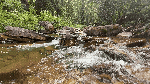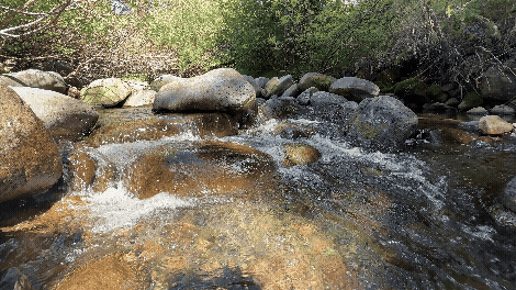
Every spring, high-country streams and rivers in the American West begin to swell with water as the region’s snowpack starts to dissipate.
It’s easy to assume that the liquid flowing in these water bodies is just fresh meltwater emanating from the preceding winter’s snowpack.
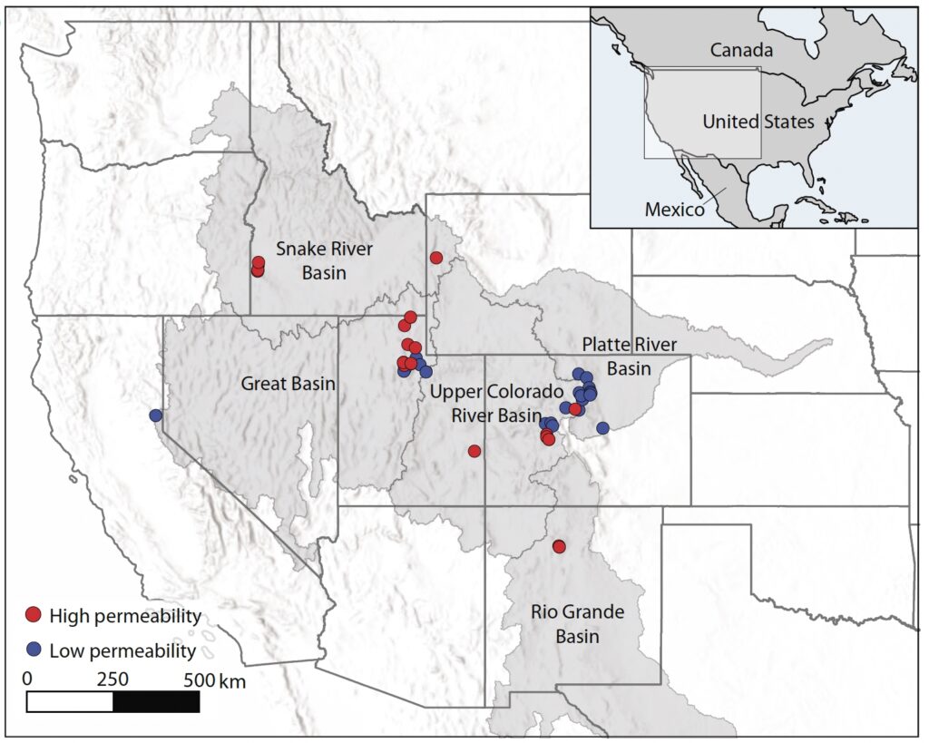
But a recent study of 42 sites across the West finds that both the conventional wisdom and some traditional hydrologic models are wrong.
Most of that vital runoff—which sustains both ecosystems and economies—is actually groundwater that is many years old.
In the headwaters they studied, the researchers found the average age of the water in streams during snowmelt runoff was 5.7 years. Overall, about 58% of the runoff was derived from older groundwater that had been essentially pushed into the stream by the newer snowmelt.
“Contrary to the common assumption that snowmelt quickly contributes to runoff, stream flow during snowmelt in western US catchments is dominated by older groundwater,” according to the study, published in Communications Earth & Environment.
The spring and summer flows in the headwaters are certainly shaped by how much snow fell during the prior months. But the researchers argue that water managers need to account for longer periods of precipitation, the underlying geology and the resulting groundwater storage if they are to make more accurate forecasts of the runoff that supplies both natural and human communities downstream.
“We think it represents a fundamental change in how we think of water resources in the West,” said lead author Paul Brooks, a professor of hydrology in the Geology and Geophysics Department at the University of Utah.
People may think the melting snowpack “runs off the surface like spilling water on your countertop,” Brooks said, but “we know it’s more complicated than that.”
Many existing models of mountain hydrology assume that shallow soils sit on top of bedrock that lies close to the surface and doesn’t let much water through. Models also assume there’s minimal change in groundwater from year to year.
But Brooks said the study shows “without a doubt, there’s large and variable amounts of groundwater storage in the mountains.”
Implications for water management
The role of groundwater recharge and storage has important implications for how the West’s limited water supply is managed. Multiyear groundwater deficits could help explain why runoff in some basins has been far below average in recent years despite decent snowpack readings. Incorporating groundwater into runoff models could make predictions more accurate and inform how water is allocated over several years, not just season by season.
For Lake Powell and Lake Mead, the two largest reservoirs on the Colorado River and in the nation, “if you had the ability to predict several years in advance, you would change your management,” Brooks said. “If we can predict when there’s going to be more or less (water) available based on how groundwater storage responds to climate, we can look at a multi-year planning cycle rather than just starting all over again every year.”
“I’m very excited about this,” Brooks said. “It came out far better than I ever could have hoped for a sabbatical project.”
Keith Musselman, an assistant professor at the University of Colorado Boulder’s Department of Geography who wasn’t involved in the study, said that hydrologists studying riparian areas in lowland valleys have long described a “piston effect” in which newer precipitation pushes older groundwater out into a river.
“What Paul Brooks and his co-authors have done is bring that to the mountains, and mountains are important because they are really where the majority of our water in the West comes from,” Musselman said. “This paper kind of ties together a number of really important studies and highlights that there is this storage system that is important to consider when we’re thinking about, particularly, water conservation, water supply planning and, ultimately, climate change impacts on our ability to provide water to society.”
Overall, snowmelt-driven streamflow and groundwater recharge in the West’s mountain watersheds are “the primary water sources for 70 million people” across 10 states in the American West, according to the study. “This water supports municipal, industrial, agricultural, hydropower, and natural ecosystems powering a $9.8 trillion economy, trailing only the entire US and China in global economic activity.”
Dating the age of runoff
During his sabbatical, Brooks pursued what he called a “high-risk, high-reward” project. He traveled across the region to collect water samples from five major river basins that were then analyzed using tritium, a radioactive form of hydrogen.
Tritium is a hydrogen isotope that occurs naturally in small amounts, but its prevalence in the atmosphere spiked in the 1950s and 1960s due to the testing of nuclear weapons during the Cold War.
When precipitation falls, it contains tritium from the atmosphere, but the isotope decays relatively quickly, with a half-life of about 12.3 years, meaning around half of it transforms into a form of helium every dozen years or so. By measuring how much tritium remains in a water sample and comparing that to the expected level when the liquid fell as precipitation, scientists can estimate the water’s age.
“It creates a very, very precise clock,” Brooks said.
Brooks and other researchers collected samples of water in the middle of winter, when the flows were low and stable, and the tritium analysis confirmed that this baseflow was derived from groundwater storage; its age averaged 10.4 years from the time it originally fell as rain or snow.
Then the scientists gathered water samples during spring and early summer, when the snowmelt was running off, and they found that the water averaged nearly six years old, meaning that groundwater was still making a major contribution to the overall streamflow.
Importance of underlying geology
Looking across the diverse sites, the researchers concluded that the underlying geology played a key role in determining the age of the runoff. The sites with younger baseflows were underlain by hard rock and shale, which are relatively impermeable, so groundwater contributed less to the flows. Sites with older baseflows were characterized by more porous rock, such as sedimentary layers, that allowed the water to infiltrate far more effectively.
“If you have a subsurface underlying geology that has very, very low permeability, there really isn’t any place for that water to be stored,” Brooks said. “If you have high permeability and higher porosity, it’s easier to get water in and there’s more places for water to store.”
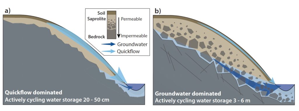
Soil moisture is another key factor that explains runoff patterns. But the authors note much more water is held in groundwater storage, and a focus on soil moisture in modeling is “also due to the fact that soils are relatively easy to measure and monitor compared to deeper groundwater.”
Brad Udall, a senior water and climate research scientist at Colorado State University’s Colorado Water Center, called the paper “eye-opening.”
“Paul and co-authors have done a really comprehensive look at a part of the water balance that heretofore has been mostly, completely understudied,” said Udall, who was not involved in the study. “It turns out this part of the water balance is looking to be more and more important in a changing climate world.”
With other studies highlighting the depletion of underground aquifers in the West, the paper’s focus on groundwater has “some pretty scary implications for future runoff in the Colorado and other Southwestern rivers,” Udall said.
“The Southwest’s water cycle has been flashing warning signs for 26 years . . . and this is just yet one more big warning to pay attention to,” he said, noting that much more research is needed on the West’s groundwater.
“What really . . . spooks me is there’s a delayed aspect of this,” Udall said. “If we’re looking at water that’s almost six years old, it means we may not see a problem until it’s six years too late, and that is particularly worrisome.”
Predicting streamflows
In Utah, Brooks said that accounting for groundwater storage has previously enabled his team to make more accurate predictions about runoff and flooding.
In 2021 and 2022, for example, Utah’s snowpack was around average, but Brooks said he and colleagues were able to correctly predict “horrendously low runoff” because they knew groundwater storage was meager. Similarly, in 2023, after a record snow year in Utah, the researchers accurately predicted only minor nuisance flooding because of the buffer of relatively low groundwater storage.
Water managers often look to April 1 snowpack readings as a barometer for the coming runoff season, but Brooks said gauging local groundwater storage in January or February can yield important insights about what’s to come in spring and summer.
“That simple number—how much groundwater is stored there relative to the long-term average—reduces your uncertainty in streamflow prediction by 50%,” Brooks said.
Measuring groundwater storage can be tricky, with nearby wells recording vastly different figures. “It’s really hard to get meaningful information on storage,” Brooks said.
However, the underlying geology across the West is widely understood from mapping and can be used to approximate whether an area has the potential to store more or less groundwater.
The researchers also argue that water managers can get a better handle on streamflows by employing tritium sampling themselves during the winter and the snowmelt season.
Brooks said he hopes the findings can be incorporated into hydrologic modeling and runoff predictions, but significant cutbacks in the federal workforce mean “it’s a very challenging time for water resource managers.”
“In an ideal world, we would have a National Science Foundation or NOAA or a private foundation say, ‘Hey, this could be really important. If we can predict streamflow more efficiently and earlier, we can make better decisions about how to manage it.’”