
By Heather Sackett
Front Range water providers are hoping to expand a program that uses a new technology they say will revolutionize water management in Colorado. But for now, the expensive program isn’t worth it for smaller Western Slope water providers.
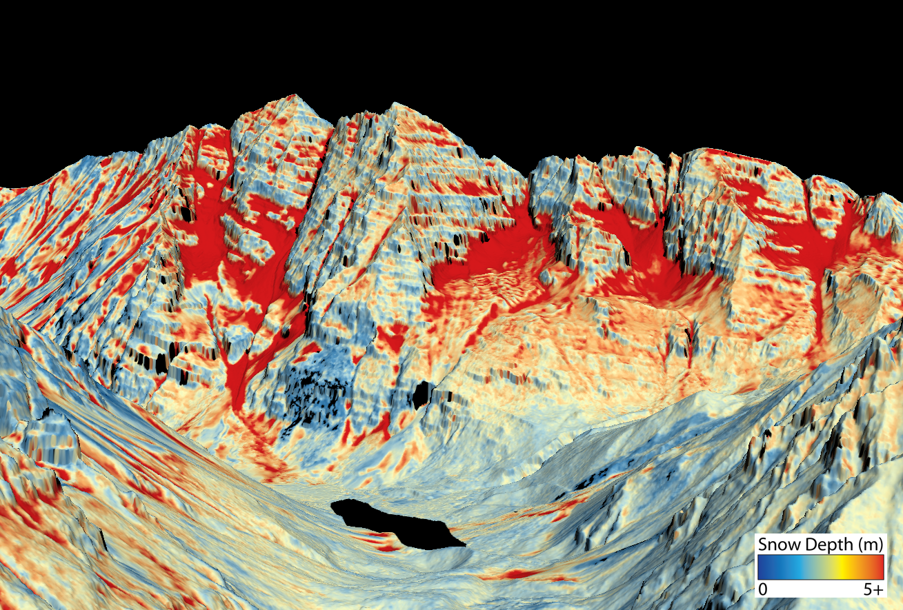
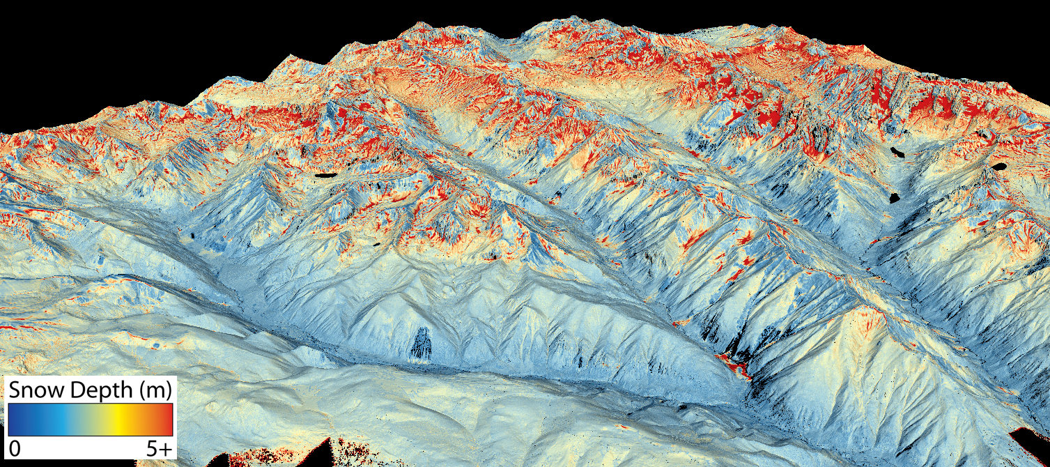
The Northern Colorado Water Conservation District is seeking state grant money to expand the Colorado Airborne Snow Observatory program. The ASO program uses remote-sensing lasers on airplanes known as LiDAR, which stands for light detection and ranging, to precisely measure snow depth and density.
The technology creates a much clearer picture of how much water is contained in the snowpack and has been used in pilot studies in the Gunnison River basin and for Denver Water.
But these flights have been scattered and lack consistent funding. A geographically expanded program with consistent funding would revolutionize water management in Colorado, according to the grant application.
“This technology is kind of a no-brainer when it comes to helping us understand what water we have to work with each year,” said Laurna Kaatz, the climate science, policy and adaptation program manager for Denver Water. “We know ASO adds value and is kind of the game-changer in water management.”
Denver Water, which provides water to 1.4 million people along the Front Range, is the ASO expansion project manager, while Northern Water is the fiscal agent. The Colorado, South Platte, Metro, Gunnison and Arkansas basin roundtables have each committed $5,000 toward the project.
SNOTEL limitations
Important data points that water managers and streamflow forecasters use for measuring snowpack — and the water contained in that snowpack, known as snow-water equivalent (SWE) — are snow-telemetry (SNOTEL) sites, a network of remote sensing stations throughout Colorado’s mountainous watersheds that collect weather and snowpack information. But they provide just a snapshot of conditions at one location.
“A large amount of SWE is in that high-elevation snow band, which doesn’t get captured by the SNOTEL program,” said Steve Hunter, utilities resource managers for the city of Aspen.
In the spring of 2019, Denver Water learned just how valuable ASO technology is in predicting runoff. Data from a June ASO flight showed there was about 114,000 acre-feet of water in the snow above Dillon Reservoir, Denver Water’s largest storage pool, even though SNOTEL sites, at about 11,000 feet, registered as melted out already. The water provider increased outflows from Dillon so they could make room for the coming snowmelt and avoid downstream flooding.
Expensive technology
ASO technology was developed by NASA and researchers at the National Snow and Ice Data Center at the University of Colorado Boulder. But the technology is expensive — between $100,000 and $200,000 per flight, according to Kaatz — and still not worth it for smaller Western Slope municipal water providers who don’t have to carefully coordinate the operation of large reservoirs.
The city of Aspen and the Eagle River Water & Sanitation District are part of the collaborative workgroup helping to create the ASO program expansion plan. Other entities include Colorado Springs Utilities, city of Fort Collins, city of Boulder, city of Greeley, Thornton Water, Pueblo Water, Aurora Water, city of Westminster, Ruedi Water Power and Authority, and the Colorado River Water Conservation District.
Hunter said more data is better when it comes to managing Aspen’s water supply, which comes from Castle and Maroon creeks. The city is trying to install a SNOTEL site and another stream gauge in its watershed. Hunter said the collaborative workgroup has also been exploring ways to sustainably fund an expanded ASO program.
“Airborne measurements of both snow depth and density to come up with your SWE is a great alternative, but it’s cost prohibitive,” Hunter said. “If they have this great technology but nobody can use because nobody can afford it, that doesn’t help anybody.”
Water managers for Eagle River Water & Sanitation District, which supplies water to the Vail Valley, said that although they are participating in the workgroup meetings and find the science interesting and useful, the expense is not something they can bite off right now. Their reservoirs are small and mostly used for augmentation, not to supply municipal water.
“I think there’s value in the whole system and understanding the water that’s available,” said Len Wright, the senior water resources engineer for Eagle River Water & Sanitation District. “But we don’t have anything that would justify the expense right now.”
Northern Water and Airborne Snow Observatories, Inc. will each contribute $5,000 worth of in-kind services to the project. Also, Denver Water will contribute $10,000 in-kind and the collaborative workgroup will give $24,000 of in-kind services. The Colorado Water Conservation Board is being asked for $20,000 from the statewide Water Supply Reserve Fund account and is scheduled to consider the grant application at its March meeting.
Aspen Journalism is a local, nonprofit, investigative news organization covering water and rivers in collaboration with The Aspen Times and other Swift Communications newspapers. This story ran in the Dec. 5 edition of The Aspen Times and the Dec. 7 edition of Aspen Journalism.
The Water Desk’s mission is to increase the volume, depth and power of journalism connected to Western water issues. We’re an initiative of the Center for Environmental Journalism at the University of Colorado Boulder. The Water Desk launched in April 2019 with support from the Walton Family Foundation. We maintain a strict editorial firewall between our funders and our journalism. The Water Desk is seeking additional funding to build and sustain the initiative. Click here to donate.


