
The snowpack that 40 million people rely on for water supplies was supposed to provide a bounty this year. Instead, much of it melted away fast and early — part of a long-term trend associated with climate change.
By Jenna Sampson
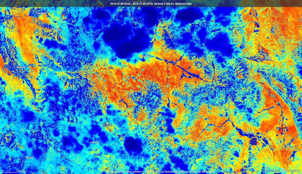
After a decent ski season was cut short by the coronavirus pandemic, Colorado’s snowpack melted away with breathtaking speed, and drought expanded dramatically.
Leading into winter, soils were already thirsty. After a snowy few months, unusual warmth set in, causing the snowmelt season to come on early and fast. Then Colorado experienced its ninth driest spring in 140 years of record-keeping.
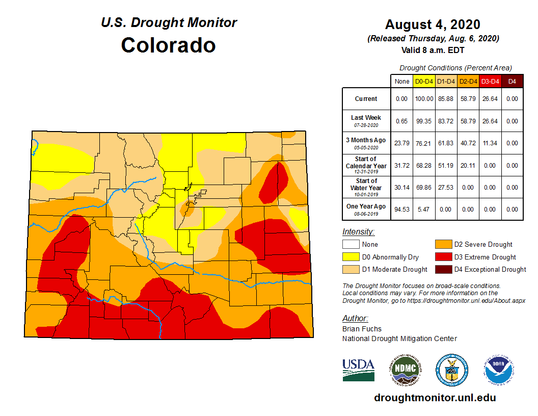
The upshot: As of early August, 100 percent of the state was abnormally dry or in some stage of drought, according to the U.S. Drought Monitor.
Beyond the water supply impacts that farmers and cities might experience in coming months, scientists say that what we saw this spring offers a taste of things to come — thanks to climate change.
And that’s not just a warmer, drier future. Climate change may already be making traditional ways of managing drought and allocating water less reliable. Among these management tools are ones used by water managers to predict what conditions will be like in just a matter of months.
The spring of 2020 offers a telling example. Thanks to the warm and dry conditions, much less water rushed into many of Colorado’s streams and rivers than water managers had forecast at the end of the winter using their traditional tools, which depend heavily on measuring the snowpack in the mountains.
Thankfully, conservation and water stored in reservoirs can see us through relatively short periods of scarcity. But over the longer run, we could find ourselves at risk of seeing our water safety net drop dangerously low.
“Global warming fundamentally changes the hydrological cycle,” says Brad Udall, senior water and climate scientist at Colorado State University’s Colorado Water Center. “Anything water managers relied on in the 20th century is not going to be applicable in the 21st.”
The reality on the ground
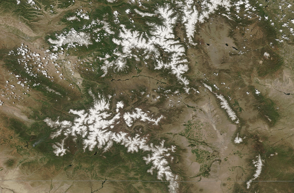
With the notable exception of the particularly dry Upper Rio Grande River Basin, most reservoir levels in Colorado were near average as of June 1, according to the most recent water supply outlook report from the Natural Resources Conservation Service. That was thanks mostly to an impressive bounty of snow during the winter and spring of 2019.
That banked water is already proving useful to Northern Water, a public agency that manages an elaborate system for collecting water on the wetter western side of the Colorado Rockies, and piping it under the mountains for use by farmers, cities and industries on the drier eastern side. Farmers in particular rely on that water to meet the needs of their late-season crops. But with the warm and dry spring, they needed extra water earlier in the season than usual.
“This project is about delivering late season water so crops can create full maturity and full yield by end of summer,” says Jeff Stahla, public information officer at Northern Water. But that’s not what has happened so far in 2020. “Farmers were starting to take their water earlier than they wanted to this year because of lack of storms.”
Northern Water’s mission “is different from others in the American West,” he notes. It is “to smooth out the peaks and valleys of the hydrology of northeastern Colorado.”
That mission is particularly important in years like this one, when runoff projections were off across much of Colorado. For example, in early March, forecasters predicted that the Upper Colorado River would swell with enough snowmelt to run at 104 percent of normal during the spring runoff season. Fast forward to early June, and the forecast had to be slashed to just 72 percent of normal.
Further downstream, the runoff flowing through the Colorado River into Lake Powell has fallen way short of expectations, which were pessimistic to begin with. In May, forecasters predicted that river flows into the giant reservoir would total just 65 percent of average through late July. As of the second week of the month, however, the actual inflow into Lake Powell, which serves as a critical hydrological savings bank for 40 million people, was much worse: just 54 percent of average.

That’s been a familiar story over the past 20 years. Stubborn drought in the Colorado River Basin, plus the need to send water to Lake Mead, its sibling reservoir downstream, have left Powell significantly depleted. On July 10, the reservoir was at just 53 percent of capacity, with outflows surpassing inflows.
With so little water, if you were taking a dip there in July, you’d be swimming 90 feet below the surface level of the lake when it is at full capacity. And you’d be looking up at the now infamous “bathtub ring,” a conspicuous white band lining the surrounding cliffs that marks where the water once stood.
Luckily, the epic snowpack of the 2018/2019 winter left the state of Colorado with that nice safety net. Even so, going into last winter, unusual warmth and lack of precipitation caused soils to get extremely dry, part of a trend highlighted by water experts like Udall. This is one of the main factors that is making it increasingly difficult for forecasters to accurately predict how much water would make its way into the system instead of being sucked up by thirsty trees and soil, or evaporating into the warm air.
With above average temperatures continuing to be seen in Colorado and many other parts of the West this summer, the same pre-winter dry-out that occurred last year could well be repeated this year — with impacts possibly extending into next.
Over the longer run, many studies have shown that climate change is already altering the water cycle in the West. For example, annual maximum snowpack in a significant portion of the Western United States — equivalent in size to South Carolina — declined by an average of around 40 percent over the 34 years between 1982 and 2016. In many parts of the West, warming temperatures have also raised the snowline, where precipitation turns from rain to snow, leaving more soil exposed. The snow that does accumulate is also tending to melt out more quickly as spring temperatures arrive earlier due to climate change. The upshot: more drying of soils.
One factor affecting parts of the southern Rockies in particular is a phenomenon called the Hadley cell, a circulation pattern arising in the tropics that affects weather far afield. As part of the phenomenon, air heats up and rises near the equator and flows northwards and southwards high above Earth’s surface. It then descends in the subtropics, in the process warming and drying areas at the surface and thereby helping to sustain deserts like the Sahara and Mohave. From these regions, the air finally returns toward the equator near the surface to complete a giant loop.
Under the influence of climate change, the planet’s Hadley cells are now expanding poleward, according to Udall. This is in turn helping to shift storm tracks northward, and drying out increasingly higher latitude regions — southern Colorado among them.
“You should be nervous if you’re in Durango,” Udall says.
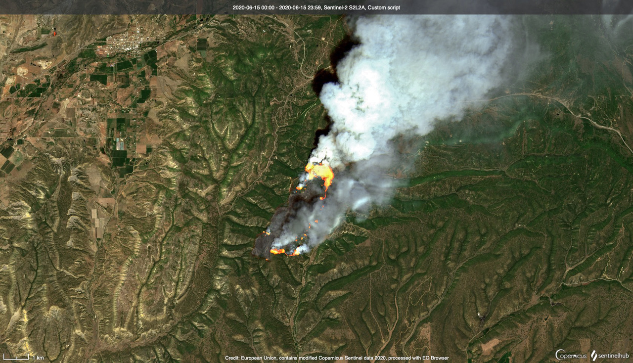
In that part of the state, unusually warm and dry conditions this spring have raised risks of wildfire. In fact, lightning striking a dry pinyon-pine forest near Durango on June 15 sparked the East Canyon Fire. Six days later, it had spread across nearly 3,000 acres, and forced the evacuation of over 35 homes. Luckily, calmer winds allowed firefighters to bring it under control, though nearly 10 new fires were kicked up in the Durango area after more lightning hit the dry region at the end of the month.
For a time this past winter, snowpack in the southern river basins of Colorado was running more or less at average. But it peaked about 10 days earlier than the historical average and melted out rapidly under record-high temperatures in late April. Not surprisingly, these areas of Colorado are the very regions now in the red zone of extreme drought.
To the north, the Upper Colorado River Basin’s snowpack actually peaked later than normal this year. But once again, warm and dry conditions then took a toll: The snowpack went into freefall during April.
Thick snowpack no longer promises brimming reservoirs
Understandably, many people look at the health of the winter snowpack and think the ensuing flows in rivers will be directly proportional, with big powder days a harbinger of an exciting whitewater rafting season to come. However, if the snowpack peaks and melts early, there is more time for exposed land to become dry, which means thirstier plants and soil, which means less water making its way into streams and rivers.
Of course, there are still plenty of big storms and anomalies, like 2018/2019’s bountiful snowpack. But as we saw this past winter, it didn’t save us from the broader, longer-term trend of warming and drying. And that trend can be self-reinforcing.
“Dry soil from one year is a memory in the system for the next year,” Udall says.
In his view, what we’re seeing now in Colorado and much of the American Southwest is likely not just a temporary drought that will be eased with more precipitation. The dramatic impact that excessive warmth has had on the crucial springtime flows of runoff in the region’s rivers is part of a phenomenon he and other experts are calling “aridification.”
This is layered on top of the natural ups and downs of climate, in which periods with a dearth of precipitation come and go from year to year. But thanks to the huge amount of heat-trapping carbon dioxide we’ve already emitted into the atmosphere, temperatures will continue to rise in coming years. With that in mind, expectations should shift toward a new baseline of increasing dryness in the already arid West, Udall says.
In fact, a study published in the journal Science this April found that human-caused global warming seems to have pushed the southwestern portion of North America — a region encompassing most of Colorado — into a multi-decadal megadrought, the severity of which hasn’t been seen since the 1500s. Without global warming, the drought, which began in 2000, would likely have been only moderately severe, according to the study.
Aridification, and the possibility of surprises in store as climate change progresses, should prompt us to change how we manage water, Udall argues. In the Colorado River Basin, for example, water management plans typically stay in place for about two decades, and then they get revisited. “I think we’re going to have to revisit these plans more often, and expect them to change in ways we can’t foresee,” he says.
Drought predictability is melting away
If this past winter and spring has shown us anything it is that relying mostly on snowpack to predict drought and water shortages arising from it can lead forecasters astray. And new findings by Ben Livneh, a University of Colorado hydrology researcher, and a colleague show this problem is likely to get worse as warming continues, causing snowpack to shrivel and drought predictability to melt away with it.
The study, published in Nature Climate Change in April, found that if emissions of heat-trapping carbon dioxide continue at high levels, by mid-century forecasters will have a much tougher time predicting seasonal drought across nearly 70 percent of the Mountain West, where snowmelt dominates the water supply. That’s for a simple reason: With more warming, there will be less and less snowpack, and thus less of the stuff essential to the current way of making predictions.
Because of its particularly tall mountains, Colorado likely will fare better than the Pacific Northwest, where the lower elevation and proximity to the ocean puts it at risk of much faster declines in snowpack, according to Livneh. But if emissions continue at high levels, by the end of the century even lofty areas like Colorado could see significant declines in snowpack that would degrade forecasters’ ability to predict drought. Water managers can try to do better in coming years by updating their toolbox with such things as measurements of soil moisture, rainfall and temperature. Satellite observations of snowpack at mountaintops — where ground measurements often are just too difficult to make, and where snow will persist longer — could also prove useful..
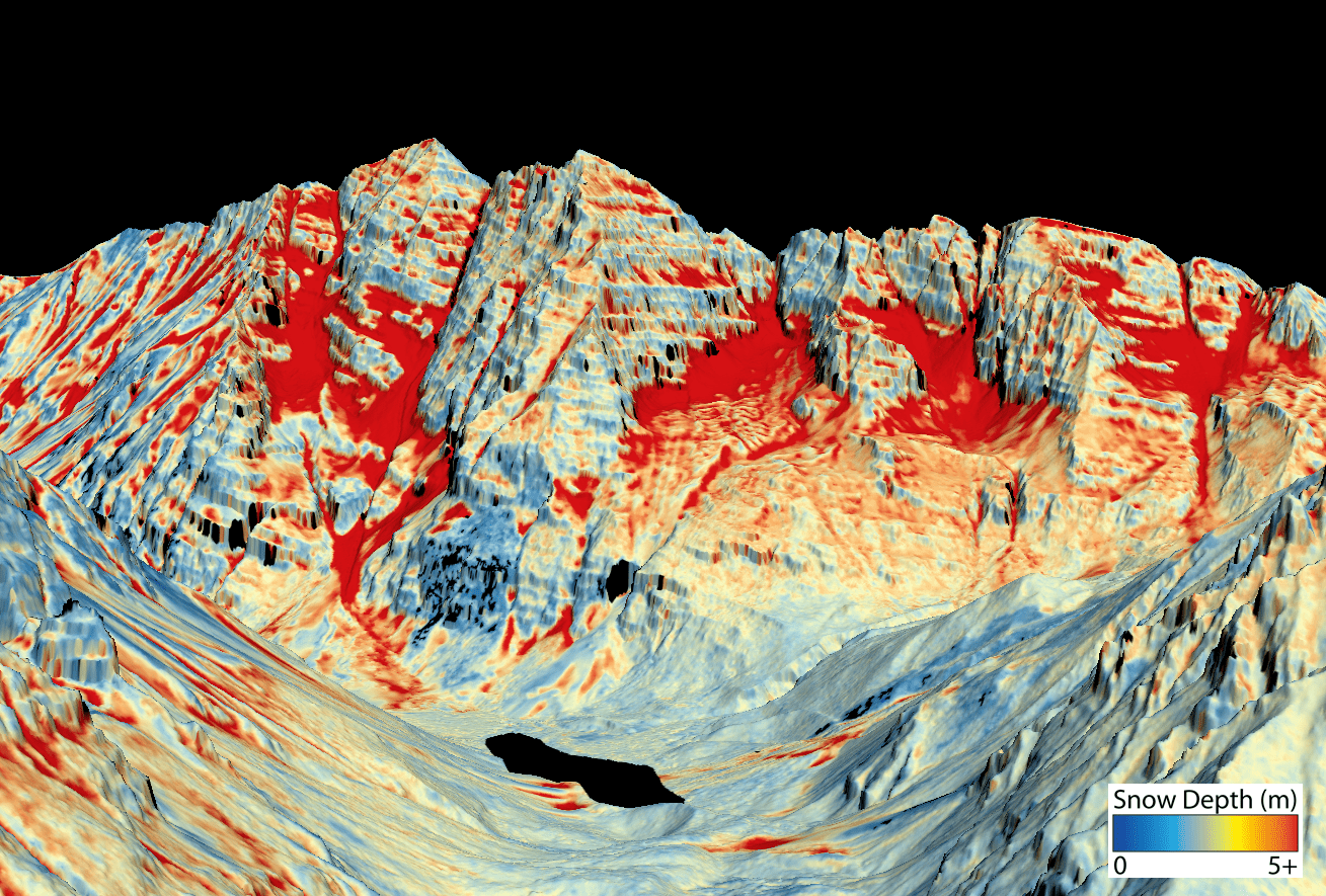
Another new approach has already been rolled out in Colorado and California: airborne measurements of the depth and water content of snow in the mountains. In the current approach, relatively sparse measurements of snowpack taken on the ground are compared with the historical record to predict runoff. The basic idea is that since certain snowpack conditions produced a given amount of runoff in the past, they’ll do so again now. But this isn’t working as well as it once did because climate change has, in effect, changed the rules of the game. According to Jeffery Deems, a research scientist with the National Snow and Ice Data Center, and co-founder of Airborne Snow Observatories, measuring snowpack from the air provides a much more complete picture of snowpack in, say, a particular watershed. Forecasters can then use that information along with with other data to model how much runoff is likely to occur, providing a more reliable prediction.
With warming, drying and earlier melt-out of snowpack, water managers are already having to grapple with significant change. Stahla of Northern Water is confident in the ability of his program to adapt — and also to heed the warning these trends are offering about the future.
As he puts it, “If you’re not concerned then you’re probably not looking at the data closely enough.”
Jenna Sampson is a freelance environmental journalist and contributor to The Water Desk. You can find her on Twitter @jennadawn. Tom Yulsman contributed to this story.


